

RU848789
-
Posts
3,616 -
Joined
-
Last visited
Content Type
Profiles
Blogs
Forums
American Weather
Media Demo
Store
Gallery
Everything posted by RU848789
-
Two Mdt to high impact events NYC subforum; wknd Jan 6-7 Incl OBS, and mid week Jan 9-10 (incl OBS). Total water equiv by 00z/11 general 2", possibly 6" includes snow-ice mainly interior. RVR flood potential increases Jan 10 and beyond. Damaging wind.
RU848789 replied to wdrag's topic in New York City Metro
No, look at the NWS office maps side by side. One can't have a discontinuity of <1" on the NWS-Philly side of the Morris/Somerset borders next to 3-4" on the NWS-NYC side of that same border. Same thing with Middlesex adjacent to Union/SI (0" next to 1-2" in SI and <1" next to 2-3" in Union). There was no collaboration, clearly.- 3,610 replies
-
- 1
-

-
- snow
- heavy rain
- (and 5 more)
-
Two Mdt to high impact events NYC subforum; wknd Jan 6-7 Incl OBS, and mid week Jan 9-10 (incl OBS). Total water equiv by 00z/11 general 2", possibly 6" includes snow-ice mainly interior. RVR flood potential increases Jan 10 and beyond. Damaging wind.
RU848789 replied to wdrag's topic in New York City Metro
No, or at least it's nuts to have MMU getting ~1", while5 miles east of there the NWS-NYC has areas of Essex County in a 3-4" swath.- 3,610 replies
-
- 1
-
-
- snow
- heavy rain
- (and 5 more)
-
Two Mdt to high impact events NYC subforum; wknd Jan 6-7 Incl OBS, and mid week Jan 9-10 (incl OBS). Total water equiv by 00z/11 general 2", possibly 6" includes snow-ice mainly interior. RVR flood potential increases Jan 10 and beyond. Damaging wind.
RU848789 replied to wdrag's topic in New York City Metro
SIAP, but this cracked me up from Tomer Burg on being NAM'd...- 3,610 replies
-
- 2
-

-
- snow
- heavy rain
- (and 5 more)
-
Two Mdt to high impact events NYC subforum; wknd Jan 6-7 Incl OBS, and mid week Jan 9-10 (incl OBS). Total water equiv by 00z/11 general 2", possibly 6" includes snow-ice mainly interior. RVR flood potential increases Jan 10 and beyond. Damaging wind.
RU848789 replied to wdrag's topic in New York City Metro
Lots of NWS office inconsistency issues. The NWS has issued winter storm watches for a general 4-8" of snow for the Poconos, Lehigh Valley, Sussex, Warren, Morris, Passaic and NW Bergen, plus the Hudson Valley N of the Tappan Zee, but the discussions from the Philly and NYC offices are somewhat at odds, with the Philly office focusing on the warmth of the ocean and easterly winds keeping accumulations <1" for 95 from Philly to Woodbridge and SE of there, while the NYC office is saying things are trending cooler and now have 2-3" for places along 95 in NENJ (Union/Hudson) and NYC. I think they're all scrambling, so it's not worth focusing on their discussions, but their maps with inconsistencies are worth discussing - just look at the boundaries along Morris/Somerset where the Philly office has <1", while magically across the border into Essex/Union, the NWS-NYC has 3-6" of snow. Also, the NWS-NYC map has 8-12" amounts for their northern counties, but the watches only mention 5-8" so I think they have some work to do to get their forecast straight.- 3,610 replies
-
- 1
-

-
- snow
- heavy rain
- (and 5 more)
-
Two Mdt to high impact events NYC subforum; wknd Jan 6-7 Incl OBS, and mid week Jan 9-10 (incl OBS). Total water equiv by 00z/11 general 2", possibly 6" includes snow-ice mainly interior. RVR flood potential increases Jan 10 and beyond. Damaging wind.
RU848789 replied to wdrag's topic in New York City Metro
NAMed! Most of this falls in part 2 on Sunday afternoon...- 3,610 replies
-
- 8
-
-
-

-

-
- snow
- heavy rain
- (and 5 more)
-
Two Mdt to high impact events NYC subforum; wknd Jan 6-7 Incl OBS, and mid week Jan 9-10 (incl OBS). Total water equiv by 00z/11 general 2", possibly 6" includes snow-ice mainly interior. RVR flood potential increases Jan 10 and beyond. Damaging wind.
RU848789 replied to wdrag's topic in New York City Metro
Fascinating that every model has 6+ inches for Boston and the NWS has a forecast for 1". I understand models are not everything, but that seems a bit out of whack to me... -
Two Mdt to high impact events NYC subforum; wknd Jan 6-7 Incl OBS, and mid week Jan 9-10 (incl OBS). Total water equiv by 00z/11 general 2", possibly 6" includes snow-ice mainly interior. RVR flood potential increases Jan 10 and beyond. Damaging wind.
RU848789 replied to wdrag's topic in New York City Metro
zoomed in - such steep gradients make for easy forecasts, lol... -
Two Mdt to high impact events NYC subforum; wknd Jan 6-7 Incl OBS, and mid week Jan 9-10 (incl OBS). Total water equiv by 00z/11 general 2", possibly 6" includes snow-ice mainly interior. RVR flood potential increases Jan 10 and beyond. Damaging wind.
RU848789 replied to wdrag's topic in New York City Metro
Looking very similar to the 18Z euro...maybe a touch warmer/wetter; below is 18Z and 0Z Euro runs through 12Z Sunday for comparison.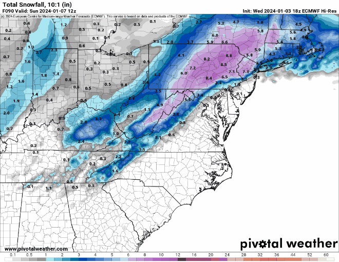
-
Two Mdt to high impact events NYC subforum; wknd Jan 6-7 Incl OBS, and mid week Jan 9-10 (incl OBS). Total water equiv by 00z/11 general 2", possibly 6" includes snow-ice mainly interior. RVR flood potential increases Jan 10 and beyond. Damaging wind.
RU848789 replied to wdrag's topic in New York City Metro
No it does not. It only takes into account the max air temp in the column and does a crude subtraction from a 10:1 ratio based on that. I've posted deeply and extensively on Kuchera. It does not address snow crystal formation/habit, aggregation while falling due to partial melting, intensity or the degree of melting at the surface due to ground temps or solar insolation, all of which can be important.- 3,610 replies
-
- 3
-
-
- snow
- heavy rain
- (and 5 more)
-
Two Mdt to high impact events NYC subforum; wknd Jan 6-7 Incl OBS, and mid week Jan 9-10 (incl OBS). Total water equiv by 00z/11 general 2", possibly 6" includes snow-ice mainly interior. RVR flood potential increases Jan 10 and beyond. Damaging wind.
RU848789 replied to wdrag's topic in New York City Metro
Yes, but I dislike Kuchera, as it's a lousy algorithm and while it's probably more realistic for this scenario, I prefer knowing how much snow is actually falling (assuming 10:1 ratio) and will do my own analysis of how much of that will likely accumulate, given how many variables there are that Kuchera doesn't take into account, plus some that aren't known well, like intensity.- 3,610 replies
-
- 1
-
-
- snow
- heavy rain
- (and 5 more)
-
Two Mdt to high impact events NYC subforum; wknd Jan 6-7 Incl OBS, and mid week Jan 9-10 (incl OBS). Total water equiv by 00z/11 general 2", possibly 6" includes snow-ice mainly interior. RVR flood potential increases Jan 10 and beyond. Damaging wind.
RU848789 replied to wdrag's topic in New York City Metro
Who do I have to pay to have this verify imby, lol? Incredible gradient from an inch or two (at the end of the storm) ~20 miles SE of me to about 8-10" at my house to over a foot 5 miles north of me. Insane.- 3,610 replies
-
- 2
-
-
-
- snow
- heavy rain
- (and 5 more)
-
Two Mdt to high impact events NYC subforum; wknd Jan 6-7 Incl OBS, and mid week Jan 9-10 (incl OBS). Total water equiv by 00z/11 general 2", possibly 6" includes snow-ice mainly interior. RVR flood potential increases Jan 10 and beyond. Damaging wind.
RU848789 replied to wdrag's topic in New York City Metro
Ignore it, like the NAM, at this range - it's a regional/mesoscale model...- 3,610 replies
-
- 1
-
-
- snow
- heavy rain
- (and 5 more)
-
Two Mdt to high impact events NYC subforum; wknd Jan 6-7 Incl OBS, and mid week Jan 9-10 (incl OBS). Total water equiv by 00z/11 general 2", possibly 6" includes snow-ice mainly interior. RVR flood potential increases Jan 10 and beyond. Damaging wind.
RU848789 replied to wdrag's topic in New York City Metro
Yep, he's fairly pessimistic on the 95 corridor and SE of there... -
Two Mdt to high impact events NYC subforum; wknd Jan 6-7 Incl OBS, and mid week Jan 9-10 (incl OBS). Total water equiv by 00z/11 general 2", possibly 6" includes snow-ice mainly interior. RVR flood potential increases Jan 10 and beyond. Damaging wind.
RU848789 replied to wdrag's topic in New York City Metro
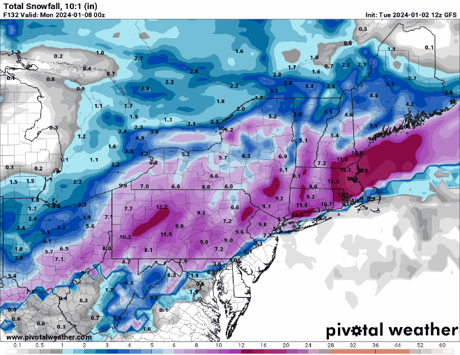
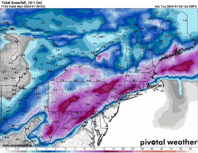
Y'all are falling down on the job, lol. I've been away (playing disc golf) for several hours and I come back to a great GFS run that came out an hour ago and nobody posted this map? It's not the JMA or the Chilean model, c'mon. More seriously as many of us have been saying, let's see what we get at 18Z/0Z tonight after all the players are being well sampled by the RAOB network. Maybe the GFS will be an outlier, maybe not, but I'd rather have it in the snowier than before camp.- 3,610 replies
-
- 3
-
-
- snow
- heavy rain
- (and 5 more)
-
Two Mdt to high impact events NYC subforum; wknd Jan 6-7 Incl OBS, and mid week Jan 9-10 (incl OBS). Total water equiv by 00z/11 general 2", possibly 6" includes snow-ice mainly interior. RVR flood potential increases Jan 10 and beyond. Damaging wind.
RU848789 replied to wdrag's topic in New York City Metro
Thanks, that's very nice of you to say. -
Two Mdt to high impact events NYC subforum; wknd Jan 6-7 Incl OBS, and mid week Jan 9-10 (incl OBS). Total water equiv by 00z/11 general 2", possibly 6" includes snow-ice mainly interior. RVR flood potential increases Jan 10 and beyond. Damaging wind.
RU848789 replied to wdrag's topic in New York City Metro
The Pivotal page is definitely well done, but they acknowledge that in marginal temp situations it's simply very difficult to translate the "snow that falls" to the "snow that accumulates." Also, as I've discussed many times over the years, Kuchera is very simplistic (it simply takes the warmest temp in the air column and has a simple algorithm reducing ratios based on that temp only) and doesn't account for snow crystal shape impact on accumulated depth nor snowfall intensity, which can easily overcome melting in some situations. IMO, as someone with significant expertise in crystallization, heat transfer and phase change dynamics, the biggest "miss" in that page is not accounting for intensity, nor the fact that once there is some accumulation on a warmer-than-32F surface, the "new" surface is now snow/slush, which, by definition is then 32F, meaning subsequent accumulation of snowfall will no longer be significantly impacted by melting on that surface, plus air temps a few degrees above 32F will have a very small melting effect, since heat transfer via air to the snow is far less than from a solid (the ground) or liquid (e.g., wet ground/puddles), due to the huge density difference, primarily (air is far less dense, which is why the heat transfer coefficient is about 20X less from air than water, for example - that's why one can kep one's hand in a -10F freezer for minutes, but can't keep one's hand in a 32F cooler filled with ice/water for more than a few seconds). This is why we can see snow accumulate quite well at high intensity in April during the day with ground and air temps well above 32F - and we're not going to have ground or air temps that far above 32F in this case, plus we're not going to have any solar insolation issues for most of the storm, at night and even during the day, as the sun angle is still quite low, so we're not going to need high intensity to accumulate well (just moderate intensity most likely, although high would be better, of course). I'm not saying we're going to see 10-15:1 snow to liquid ratios (which is what we'd likely get with good dendritic growth we're likely to see where the snow crystals are being formed, if that snow didn't encounter above 32F air in the column nor above 32F ground), but I am saying getting to 8-10: ratios shouldn't be that much of a stretch, as long as we have decent intensity.- 3,610 replies
-
- 8
-
-
-
- snow
- heavy rain
- (and 5 more)
-
Two Mdt to high impact events NYC subforum; wknd Jan 6-7 Incl OBS, and mid week Jan 9-10 (incl OBS). Total water equiv by 00z/11 general 2", possibly 6" includes snow-ice mainly interior. RVR flood potential increases Jan 10 and beyond. Damaging wind.
RU848789 replied to wdrag's topic in New York City Metro
I'd say we have a slight improvement, lol, across the board from 12Z to 0Z for the vast majority of the subforum and even from DC to Boston (except for areas well NW/inland, but they haven't had close to 0" of snow since 2022). Better confluence, colder air, better track. Now let's see if we can maintain this kind of consensus for a significant to major snowfall over the next 4 days - crossing fingers and I'm not superstitious, lol.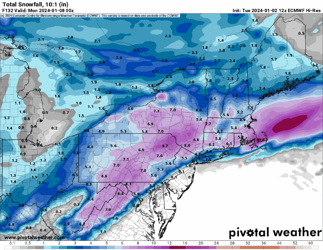
- 3,610 replies
-
- 3
-
-
- snow
- heavy rain
- (and 5 more)
-
Two Mdt to high impact events NYC subforum; wknd Jan 6-7 Incl OBS, and mid week Jan 9-10 (incl OBS). Total water equiv by 00z/11 general 2", possibly 6" includes snow-ice mainly interior. RVR flood potential increases Jan 10 and beyond. Damaging wind.
RU848789 replied to wdrag's topic in New York City Metro
Colder/snowier. 4 for 4 tonight...- 3,610 replies
-
- 2
-
-
-
- snow
- heavy rain
- (and 5 more)
-
Two Mdt to high impact events NYC subforum; wknd Jan 6-7 Incl OBS, and mid week Jan 9-10 (incl OBS). Total water equiv by 00z/11 general 2", possibly 6" includes snow-ice mainly interior. RVR flood potential increases Jan 10 and beyond. Damaging wind.
RU848789 replied to wdrag's topic in New York City Metro
Every model, so far tonight, has made significant increases in snowfall amounts for almost everyone in the 95-corridor and towards the coast, as well as nearby NW suburbs. Now we wait to see what the Euro says and if we can maintain such a snowy forecast through the next few days and actually see the snow. Really would love to see the forecast/track hold after all the players are within the RAOB network sometime tomorrow (hoping we're not missing some key initialization data). -
Two Mdt to high impact events NYC subforum; wknd Jan 6-7 Incl OBS, and mid week Jan 9-10 (incl OBS). Total water equiv by 00z/11 general 2", possibly 6" includes snow-ice mainly interior. RVR flood potential increases Jan 10 and beyond. Damaging wind.
RU848789 replied to wdrag's topic in New York City Metro
Correct. Here it is if interested. Also, the link below has a very nice summary of what the model consists of, especially with regard to the various model inputs which get "blended" in the BOM (they're not all equal). https://luckgrib.com/models/nbm_conus/- 3,610 replies
-
- 3
-
-
-
- snow
- heavy rain
- (and 5 more)
-
Two Mdt to high impact events NYC subforum; wknd Jan 6-7 Incl OBS, and mid week Jan 9-10 (incl OBS). Total water equiv by 00z/11 general 2", possibly 6" includes snow-ice mainly interior. RVR flood potential increases Jan 10 and beyond. Damaging wind.
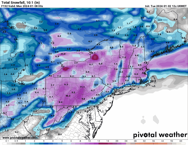
RU848789 replied to wdrag's topic in New York City Metro
So, what do we have to do to make this happen? Damn this looks nice, even if it's 5+ days out. -
Two Mdt to high impact events NYC subforum; wknd Jan 6-7 Incl OBS, and mid week Jan 9-10 (incl OBS). Total water equiv by 00z/11 general 2", possibly 6" includes snow-ice mainly interior. RVR flood potential increases Jan 10 and beyond. Damaging wind.
RU848789 replied to wdrag's topic in New York City Metro
Good points. To amplify further, one thing most don't appreciate is that with moderate to heavy snowfall rates, ground melting will be overcome quickly and once there is a layer of snow on the ground, that snow, by definition is at 32F (or colder), meaning subsequent snowfall has a negligible melting rate, even if the air temp is a degree or two above 32F. Also, sun angle is quite low and antecedent temps will likely be not far above 32F, so initial ground melting will likely be quite low anyway. I also remember the old E/E rule (Euro/ETA - old name for NAM). Let's just hope we get snow (the vast majority around here want that, lol).- 3,610 replies
-
- 1
-
-
- snow
- heavy rain
- (and 5 more)
-
Two Mdt to high impact events NYC subforum; wknd Jan 6-7 Incl OBS, and mid week Jan 9-10 (incl OBS). Total water equiv by 00z/11 general 2", possibly 6" includes snow-ice mainly interior. RVR flood potential increases Jan 10 and beyond. Damaging wind.
RU848789 replied to wdrag's topic in New York City Metro
Yeah, couldn't care less whether we have a significant snowfall which is washed away 3 days later - I just want to see some decent friggin' snow for the first time in a long time.- 3,610 replies
-
- 3
-
-
- snow
- heavy rain
- (and 5 more)
-
Two Mdt to high impact events NYC subforum; wknd Jan 6-7 Incl OBS, and mid week Jan 9-10 (incl OBS). Total water equiv by 00z/11 general 2", possibly 6" includes snow-ice mainly interior. RVR flood potential increases Jan 10 and beyond. Damaging wind.
RU848789 replied to wdrag's topic in New York City Metro
Really liked Upton's discussion today... Attention then turns to the second half of the weekend. While there is a general agreement on a potential storm system to pass near the region Saturday night and Sunday, confidence is very low on any specific impacts including precipitation types, precip amounts, and winds. The exact timing is uncertain, but appears to occur sometime Saturday night into Sunday/Sunday night. The 12z deterministic and ensemble suite includes scenarios that give the area an all snow event, a mixed precipitation event, or one that has at least the southern half of the area in plain rain with potential of wintry precip inland. There are also solutions that indicate the system passing far enough south that little to no precip occurs in the CWA. It is important to stress that any of these solutions are possible, but we cannot say with any confidence which one will occur. The model guidance is likely to waiver many times in the next several days as the main southern stream energy is still over the north central Pacific. The energy looks to reach the western US Tuesday night into Wednesday. The evolution of the northern stream over southern Canada is also important to the outcome from this potential system. The NBM does indicate a respectable 70 percent chance of measurable precip (greater than 0.01") during time frame, and about a 50 percent chance of greater than 0.25". Deciding to Cap PoPs off at 50 percent for now given that it is still just under a week out. Precipitation types will be fine tuned as models converge and forecast confidence increases.- 3,610 replies
-
- 1
-
-
- snow
- heavy rain
- (and 5 more)
-
Two Mdt to high impact events NYC subforum; wknd Jan 6-7 Incl OBS, and mid week Jan 9-10 (incl OBS). Total water equiv by 00z/11 general 2", possibly 6" includes snow-ice mainly interior. RVR flood potential increases Jan 10 and beyond. Damaging wind.
RU848789 replied to wdrag's topic in New York City Metro
Faster system, precip arrives after dark, plenty of snow, verbatim. Significant snow on the table is all I'm looking for at this point.