

RU848789
-
Posts
4,002 -
Joined
-
Last visited
Content Type
Profiles
Blogs
Forums
American Weather
Media Demo
Store
Gallery
Everything posted by RU848789
-
Snowfall NYC subforum Jan 6 and OBS if needed
RU848789 replied to wdrag's topic in New York City Metro
3" line moved ~30 miles N and the ~1" line moved 10-15 miles N. Progress.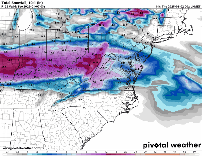
-
Snowfall NYC subforum Jan 6 and OBS if needed
RU848789 replied to wdrag's topic in New York City Metro
A small uptick on the CMC and later precip too...warning snows south of 276/195 and advisory snows from there up to 78, i.e., all of CNJ. -
Snowfall NYC subforum Jan 6 and OBS if needed
RU848789 replied to wdrag's topic in New York City Metro
Yessiree! That along with the ICON getting much snowier for areas N of 276/195 are good signs...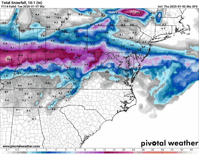
-
Snowfall NYC subforum Jan 6 and OBS if needed
RU848789 replied to wdrag's topic in New York City Metro
Enough said, thanks. My one comment for the author of that AFD would be to perhaps address the NBM/precip inconsistency, especially given how often the NBM is invoked by the NWS as a major aid in forecasts. -
Snowfall NYC subforum Jan 6 and OBS if needed
RU848789 replied to wdrag's topic in New York City Metro
A bit off topic, but below was my recap for the 1/19 event (for my email lists/FB/other non-weather forums - I post a lot more in those places than here, since most posters here are pretty knowledgeable), discussing that sharp cutoff and the graphic that showed it pretty clearly. We got very lucky in Metuchen for this one. Brief Recap of 1/19 Event: The NWS forecast was excellent for everyone about 5-10 miles south of 78 and south of there, with 2-4” from there down to about 276/195 and a general 4-6” from along 276/195 down through the rest of SEPA, SNJ, DE, MD, etc., as that’s where the Norlun Trough set up. As I feared from just south of 78 northward, the NWS forecast busted, as snowfall was 1-2” near 78 and generally <1.5” N of 78, including <1” for almost all of NENJ, NYC, SENY and LI; the exception was Sussex/Poconos where 2-3” fell. We got very lucky in Metuchen, where we got 2.9” vs. my forecast of 3.3” at my house, as the radar showed the moderate to heavy echoes including us, but slammed shut just a few miles north of me (too much dry air to the north), which is why Clark, just 6 miles north of me only got about 1”. So, NYC continues its snow futility, but Trenton, Philly, Wilmington, Baltimore and DC all got 4” or more, breaking their snow futility streaks, as per the 2nd graphic below. -
Snowfall NYC subforum Jan 6 and OBS if needed
RU848789 replied to wdrag's topic in New York City Metro
Thanks for the insights. Unfortunately, if certain folks in the incoming administration have their way, we might not have a NWS any more or at least not one that makes forecasts - perhaps they'll only be the collector/provider of data for private firms to use for their paid forecasts. I hope it doesn't come to that as I've always liked having professional mets at the NWS offices with great general meteorological knowledge paired with strong local knowledge of the area's weather. -
Snowfall NYC subforum Jan 6 and OBS if needed
RU848789 replied to wdrag's topic in New York City Metro
Yes, I noticed that - they actually upgraded their probabilities of snow from yesterday at 4 pm to today at 4 am in the AFD, but they're still "conservative" from a prediction perspective wanting to maintain continuity with previous forecasts, but the problem is that they're not being "conservative" at all with regard to alerting the public - a conservative approach there would be to play up the threat at least a bit so people aren't surprised on Monday if there's 1-2" in NNJ/NYC and 2-3" in CNJ. -
Snowfall NYC subforum Jan 6 and OBS if needed
RU848789 replied to wdrag's topic in New York City Metro
Well, CPK got 2.3" last Jan, while we got 7.3" (2.0" on 1/2, 2.4" on 1/15 and 2.9" on 1/19) and they only got 7.5" all winter while we got 24.6" in Metuchen, which was an insane difference. -
Snowfall NYC subforum Jan 6 and OBS if needed
RU848789 replied to wdrag's topic in New York City Metro
Look at the two maps I just posted above - significant disconnect, clearly, especially since it's the National Weather Service Blend of Models. I'm glad I'm not the one having to make this forecast, lol. -
Snowfall NYC subforum Jan 6 and OBS if needed
RU848789 replied to wdrag's topic in New York City Metro
Interesting that the NBM snowfall forecast bumped up for 07Z vs 01Z last night and yet the NWS-Philly is clearly downplaying the event potential north of Philly, as per the part I bolded below, when they often follow the NBM for snow events. Maybe they're going by the WPC precip forecast and not the NBM snowfall forecast... @MGorse- any comments on this apparent disconnect? Just trying to figure out what you guys are thinking, thanks... National Weather Service Mount Holly NJ 401 AM EST Thu Jan 2 2025 LONG TERM /SUNDAY THROUGH WEDNESDAY/... Guidance from a synoptic standpoint is depicting a Miller B nor`easter to develop with an upper level trough swinging a surface low from west to east across the KY/TN area before redeveloping as a low pressure system offshore Monday. Ensemble guidance is split into 2 different clusters with the variance generally explained by how strong the upper level ridge will be over Quebec. This boils down into two scenarios, one with a more northern track bringing snow towards the RDG/TTN/PHL, and one with a more southern track keeping the snow more over the DC area. The more northern stream track relies on a weaker high and thus develops a bit more cyclogensis over our region thus lifting the band of 2-4 inches of snow further north, whereas in the southern track, the high is stronger and displaces the surface low to the south more leading to most of the area seeing little in the way of snow. 01Z/02 NBM generally is taking a blend of the two scenarios thus leads to probabilities similar to the 13z/01 NBM with snowfall greater than 1 inch is 60 to 80 percent across southern New Jersey, the Delaware Valley including Philadelphia, and the eastern shores of Maryland and Delaware while the probability of snowfall greater than 3 inches is 40 to 50 percent. North of Philadelphia, probabilities lower to 30 to 50 percent for greater than 1 inch of snow and 20 to 30 percent for greater than 3 inches of snow. For the time behind will continue to show a blend of the two tracks but anticipate that the gradient of snowfall will sharpen quickly somewhere north of Philadelphia over the coming runs depending on how guidance handles the upper level ridge. While it is still too soon to tell how much snow will fall, the trend looks to be for advisory level snowfall for Delmarva, sub- advisory amounts for southeast New Jersey and the Delaware Valley, and minimal amounts north of Philadelphia.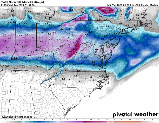
-
Snowfall NYC subforum Jan 6 and OBS if needed
RU848789 replied to wdrag's topic in New York City Metro
So the 0Z Euro is a step back from 18Z for NYC Metro, but is still better than 12Z was and is somewhat more in line with the rest of the 0Z suite. If the storm was tomorrow, I'd go with the NBM, i.e. ~2" along 80 (including NYC) increasing as one goes south to 3-4" along 276/195 and more south of there (meaning 2-3" for most of CNJ). I'd take that, considering things were looking like <1" for most folks N of 276/195 until this evening, although I also won't turn down further increases, lol.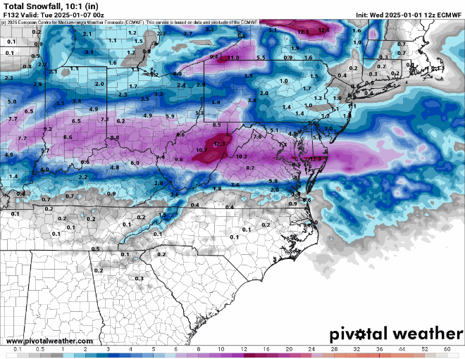
-
Snowfall NYC subforum Jan 6 and OBS if needed
RU848789 replied to wdrag's topic in New York City Metro
UK also showed improvement relative to 12Z, if you live north of Wilmington to AC. Euro up next - hoping it at least doesn't backtrack from 18Z...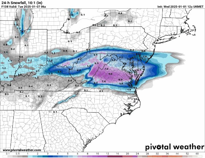
-
Snowfall NYC subforum Jan 6 and OBS if needed
RU848789 replied to wdrag's topic in New York City Metro
CMC joins the party - loving the trends since the 18Z Euro...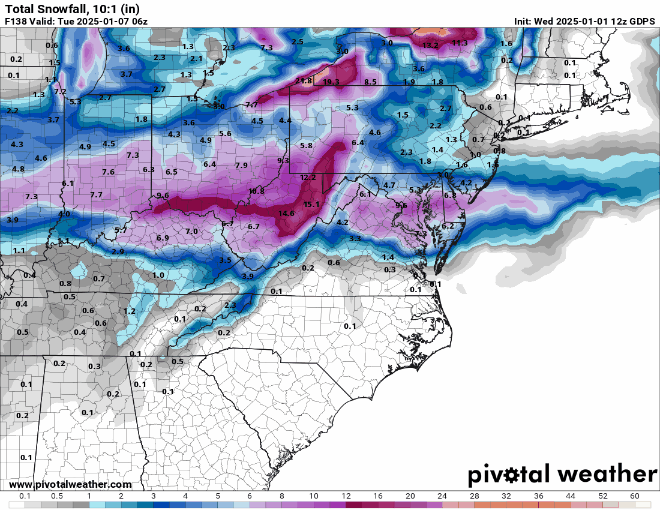
-
Snowfall NYC subforum Jan 6 and OBS if needed
RU848789 replied to wdrag's topic in New York City Metro
Euro at 18Z and ICON/GFS at 0Z. Good trends.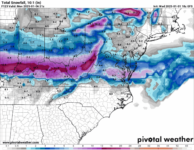
-
Snowfall NYC subforum Jan 6 and OBS if needed
RU848789 replied to wdrag's topic in New York City Metro
Yep, big jump in snowfall on the EPS for areas north of DC-Cape May, so this wouldn't appear to be an Op outlier (not like that nutty 12Z GFS run showing 12"+ in the deep south today, while the GEFS showed barely nada).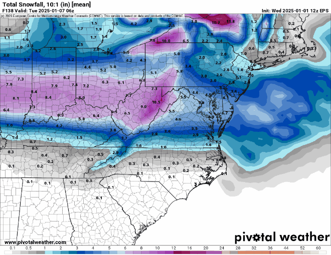
-
Snowfall NYC subforum Jan 6 and OBS if needed
RU848789 replied to wdrag's topic in New York City Metro
Nice! Let's hope this is the start of a trend towards at least some snow for our area (and maybe more than a few inches) - and with temps in the 20s, melting/accumulation wouldn't be an issue, plus we might do better than 10:1, if we can get good dendritic growth (which is not a factor in the Kuchera algorithm, which is why I don't post those maps). -
Snowfall NYC subforum Jan 6 and OBS if needed
RU848789 replied to wdrag's topic in New York City Metro
Exhibit #877 on why putting any stock in Op models beyond 6-7 days is fruitless, as the 18Z GFS comes back to reality for SE US snow vs. 12Z and why ensembles are the way to go. Obviously, the 12Z GFS was an outlier solution for SE snow given that probably every other member had little to no snow. While the ~10 day Op runs of the Euro/GFS for the 1/10-11 window haven't looked great for our area the past few Op runs, we're still ridiculously far out, so let's see how it plays out. And hope for an inch or two on 1/6.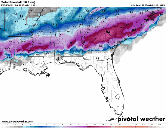
-
Snowfall NYC subforum Jan 6 and OBS if needed
RU848789 replied to wdrag's topic in New York City Metro
Good call, although it's interesting to see how different the GEPS is vs. the Op CMC at 12Z. The Op having so little precip must be a dry outlier for the ensemble mean to be so much wetter/snowier. -
Snowfall NYC subforum Jan 6 and OBS if needed
RU848789 replied to wdrag's topic in New York City Metro
Yes, we've both posted the NBM model inputs before, but as far as I know, many of those models don't run out 120+ hours and there are some I don't have access to and the ones I do aren't showing that much snow through 1/6. So still puzzled. -
Snowfall NYC subforum Jan 6 and OBS if needed
RU848789 replied to wdrag's topic in New York City Metro
Interesting that the NBM has bumped up snowfall a bit at 13Z vs. previous runs, especially along/S of 78, when none of the major globals are showing anywhere near that amount of snow (just small upticks on the Euro, especially N of 276/195. I know many more models go into the NBM, but I'll admit I'm puzzled.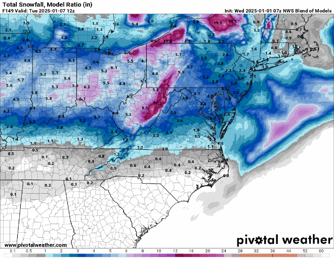
-
Snowfall NYC subforum Jan 6 and OBS if needed
RU848789 replied to wdrag's topic in New York City Metro
NAM! Just kidding. Getting ready for our annual NYE party, so no model watching for the next ~12 hours or so, and figured it's fairly dead between model suites. Happy New Year All! -
Snowfall NYC subforum Jan 6 and OBS if needed
RU848789 replied to wdrag's topic in New York City Metro
Minor point, but the BOM graphic has no title on it, so one can't see what run it is nor how far out the run goes - wondering if it's "snipped" instead of copied/pasted. Looks like it's today's 07Z run thru 1/9 at 0Z. Completely agree patience is key here with so many models/solutions and still being 7+ days out. -
Did you see the 6Z GFS? Has a general 1-3" snowfall for most of EPA/NJ/SENY (including Philly/NYC) on 1/6 and then has a monster snowstorm with a foot or more for the region on 1/10. Kind of fits your two thread idea.
-
Zoomed in, since this is the NYC forum - I'll take two of these, please, lol. Still almost 8 days out, so no surprise the Ops aren't aligned, but at least the major ensembles are fairly aligned for decent snowfall through day 10+. I check about twice a day for a few minutes, since the uncertainty is still way too high for Op run consistency or reliability. As many have noted, the biggest story could end up being brutal cold in the SE US, which could lead to major crop damage in Florida and temps near 32F as far south as Miami (last freeze there was in 1989).
-
Buckle up folks, social media is about to go wild, but as amazing as this pattern looks, we all know that 11-day forecasts are highly uncertain and there are things that could go wrong to wreck the virtual snow we're looking at now. As others have said, I'll be very interested, but I'm not going to start getting really excited about anything until I see some general consensus within 6-7 days, i.e., the timeframe when numerical weather prediction, which is inherently chaotic, starts to become more certain - that's why the NWS, who knows a thing or two about forecasting, doesn't issue forecasts beyond 7 days.


