RU848789
Members-
Posts
3,616 -
Joined
-
Last visited
Content Type
Profiles
Blogs
Forums
American Weather
Media Demo
Store
Gallery
Everything posted by RU848789
-
Refresher snow & obs between ~midnight and Noon Sat Feb 17 2024
RU848789 replied to wdrag's topic in New York City Metro
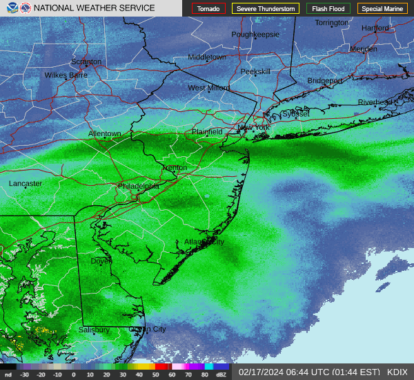
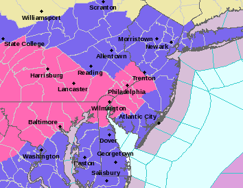
As of 2.15, 5.5" otg so 3"/hr rate last 30 minutes. This is a once in 10 year deformation snow band. It's insanely gorgeous out there... this is almost like lake effect snow. NWS just put out a warning for Middlesex for 4-6" more snow after 2 am and for Somerset, Mercer and Hunterdon for 3-5" more snow after 2 am. That means we could hit 10" here. This reminds me of that incredible inverted trough band of 10" they got at an Eagles game several years ago. -
Refresher snow & obs between ~midnight and Noon Sat Feb 17 2024
RU848789 replied to wdrag's topic in New York City Metro
-
Refresher snow & obs between ~midnight and Noon Sat Feb 17 2024
RU848789 replied to wdrag's topic in New York City Metro
4" otg as of 1.45 pm so we're at 4"/hr rates the last 30 min which is close to the most I've ever seen. If this somehow keeps up even at "just" 1-2"/hr for a few hours we'll get 8" or more! -
Refresher snow & obs between ~midnight and Noon Sat Feb 17 2024
RU848789 replied to wdrag's topic in New York City Metro
Holy crap! Dozed off at midnight with light snow having just started and woke up at 1 am to deathband snow! We havre 2" otg as of 1.15 am which is incredible! Spectacular huge debrief dendrites... ratios must be at least 15.1. 30F. https://cdn.discordapp.com/attachments/1207471347551309864/1208299075137577001/20240217_011043.mp4?ex=65e2c734&is=65d05234&hm=20993d2259528f5e31cb9b7bddfd3729eee38db3ae2999993a43508d090c836d& -
Refresher snow & obs between ~midnight and Noon Sat Feb 17 2024
RU848789 replied to wdrag's topic in New York City Metro
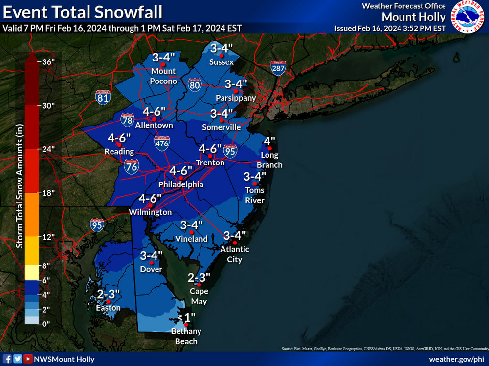
Well there's this map so clearly mt holly has a mask... they just are late in posting it... union County ftw! (6 miles N of me lol) -
Refresher snow & obs between ~midnight and Noon Sat Feb 17 2024
RU848789 replied to wdrag's topic in New York City Metro
-
Refresher snow & obs between ~midnight and Noon Sat Feb 17 2024
RU848789 replied to wdrag's topic in New York City Metro
Has anyone seen an updated mt holly map yet? -
Refresher snow & obs between ~midnight and Noon Sat Feb 17 2024
RU848789 replied to wdrag's topic in New York City Metro
-
Refresher snow & obs between ~midnight and Noon Sat Feb 17 2024
RU848789 replied to wdrag's topic in New York City Metro
-
Refresher snow & obs between ~midnight and Noon Sat Feb 17 2024
RU848789 replied to wdrag's topic in New York City Metro
Lee Goldberg occasionally cites the RAP... -
Refresher snow & obs between ~midnight and Noon Sat Feb 17 2024
RU848789 replied to wdrag's topic in New York City Metro
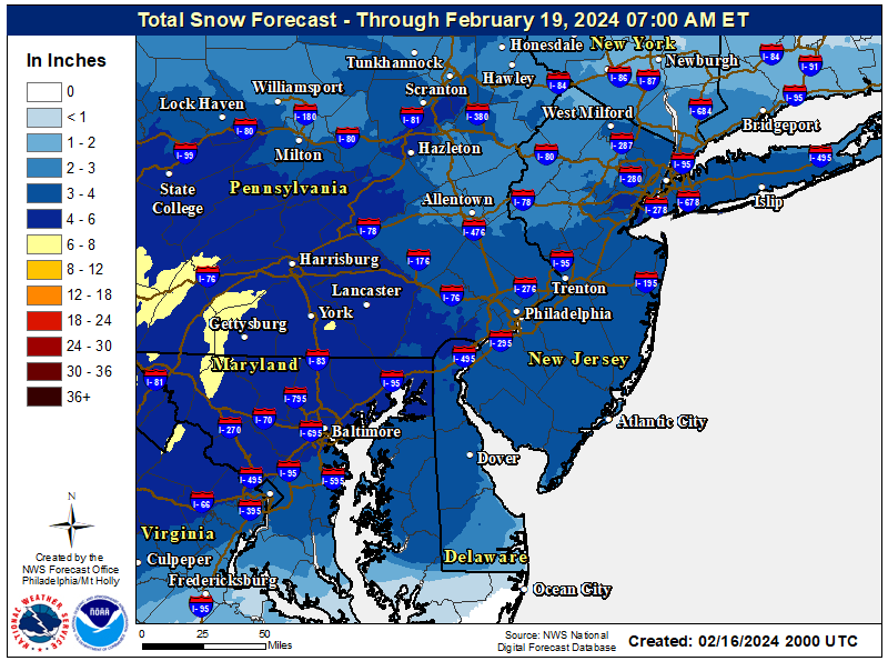
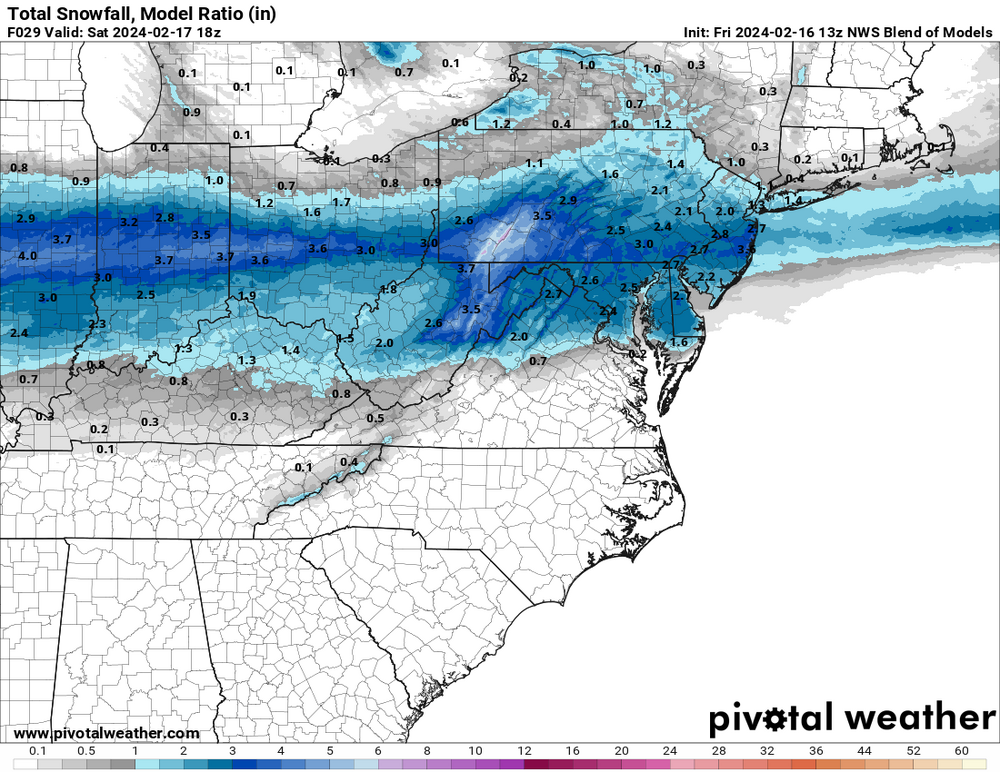
NWS regional snowfall forecast. NWS also noted that 2-3" amounts might easily extend north to include the rest of NNJ, NENJ, NYC, and LI. -
Refresher snow & obs between ~midnight and Noon Sat Feb 17 2024
RU848789 replied to wdrag's topic in New York City Metro
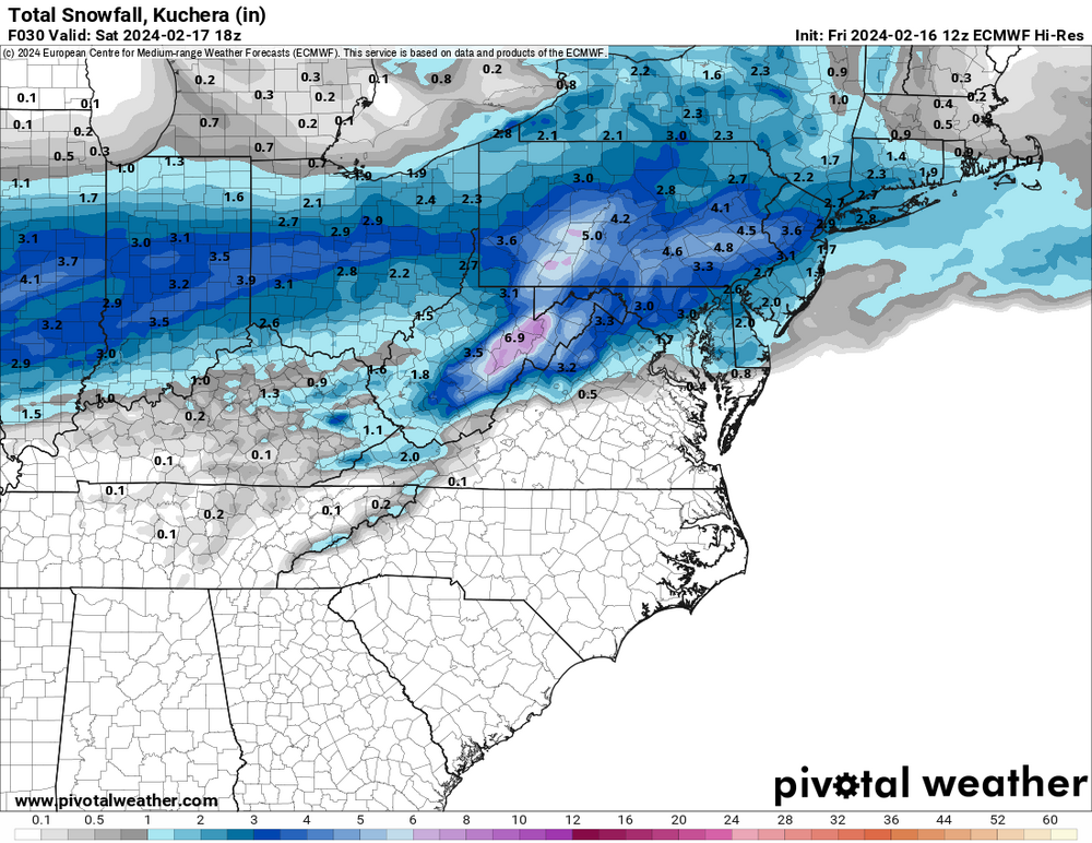
Based on one NAM run that's a little dry? I'll take the RGEM and CMC over the NAM/GFS (showing it's SE bias again) any day. Also, let's see how the rest of the model suite plays out. If the Euro/UK trend drier, then the concern is likely warranted, but if they hold serve, it's time to be a bit more confident in a 1-3" snowfall. Ratios might also be >10:1, but not convinced about that without better omega (cold isn't everything). -
Refresher snow & obs between ~midnight and Noon Sat Feb 17 2024
RU848789 replied to wdrag's topic in New York City Metro
NWS-Philly updated their snowfall map While it's a fairly minor event, assuming we get 1-2" (3" would be nice), it will be impactful on Saturday morning travel, as every flake will accumulate with below 32F temperatures during the event, which will be from around 1 am through 10 am. Roads should be fine by late morning as precip stops and we get more indirect sunlight and temps go above 32F for most, except for far NW locations. -
Good point on elevation as it's always important, but I think the main reason areas 10-20 miles and more NW of 95 got a lot more snow with this system was that precip amounts were much greater not that they were at elevation; much of the 95 corridor from Trenton to NYC got stuck in a subsidence zone for 2-3 hours with much less snow falling, as per the radar in real time and the graphic below shows the stark difference of 0.4-0.6" QPF falling from 1 am to 1 pm (precip was over for everyone by then) for the whole 95 corridor from CNJ through NYC vs. 0.8-1.2" QPF for most of NEPA, NWNJ and the Hudson Valley. And this difference was even worse from 8:30-11:30 am, which was the prime time for heavy snow and we got only 1.5" during that time, which was less than we got during the one hour from 7:30-8:30 am (1.75" of snow) - I easily would've had 9-10" instead of 6" if I had gotten the precip amounts those NW of me got and I think the same is true for much of the 95 corridor locations from CNJ through NYC/NENJ - we would've kept snowing heavily and accumulating, if only we got the precip, but we didn't. Where elevation and temp certainly played a difference was the timing of the changeover to snow, as it was colder, earlier, further NW (not unusual in these setups). We lost a few tenths of precip to rain before changing at 4:30 am, whereas areas well NW, changed 2-3 hours earlier, getting probably 1-2" more during that time (precip wasn't as heavy). Also if it was just elevation playing a role, then why did so many locations SE of the fall line (I'm about 8-9 miles SE of it) even get 5-7", as in Middlesex/Somerset counties? As an aside, lack of precip intensity is almost certainly why areas from Philly SE through SNJ got very little snow (an inch or so near Philly and little to no snow SE of there. The precip wasn't heavy enough early on to dynamically cool the column (plus they changed oer to snow even a few hours later than we did) and then by mid-morning, when temps were finally cooler, the precip still wasn't heavy enough.
-
NWS first map, but only through 7 am Sat and while it looks like the precip is 80-90% over by then, it's not done yet on some of the models - don't know why they can't just do these through the end of the storm.
-
Also colder aloft is meaningless if one doesn't have good moisture lift in the DGZ, providing the necessary supersaturation to drive the kind of rapid nucleation of ice crystals and vapor phase deposition/growth on those crystals resulting in low bulk density dendrites. Without the proper dynamics in the DGZ one can still get plates and rods which would likely give 10:1 ratio snow. What cold does avoid, however, is melting/mangling/aggregation of those crystals from falling through >32F layers. Don't know enough about the dynamics on this one to guarantee higher ratio snows.
-
NAMed? Kind of...
-
Newark was 8.4:1 and even at my house in Metuchen it was 8.3:1. I'm guessing everywhere NW of the TPK from Trenton to Newark also had ratios of at least 8:1. East of the TPK in NENJ/NYC it was often lower, possibly due to lower intensity, possibly the UHI. And I assume it was at least 10:1 N of 78/W of 287 in NJ and N of 287 in NY.
-
So, CMC, RGEM, Icon and NBM are good for 1-2" (and 3" in spots) for most of the area while the GFS/NAM have 1" or less generally. Let's see what the UK/Euro bring. Would love to get even a little more snow - not sure ours will last until Saturday.
-
Was just about to post this. That's respectable as opposed to the NAM. Might need a thread soon, as this is <3 days away and even a 1-3" event is noteworthy, IMO, in a winter like this.
-
It's all about intensity in marginal setups (and getting snow instead of rain, lol - the changeover was delayed from about 276/195 southward where people really got a lot less than modeled and forecast by some) - see my latest post on that. We got 6" in Metuchen with an 8.3:1 ratio and temps generally 33F for the storm. Anyway, here's a good map on snowfall amounts. Also, Bordentown is barely CNJ and much of CNJ got 5-8".
-
Snow ratio time. I like the cuboid method over the core method: I simply carve a 10" x 10" slice of snow and shove it into a big bowl, melt it and measure the volume vs. the snow height I measured (it's a much bigger volume than most cores, so it should have less error associated with the measurement. I had 9832 cc volume in my 10"x10"x6" cuboid vs. 1180 cc of melted snow, so my ratio was 8.33:1, which was very close to Newark's 8.4:1. I suspect it was much lower over the first hour or two, when we had 1/4" or so of sleet followed by fairly wet snow, but that was maybe the first inch of depth. Once we started getting higher intensity snowfall it clearly was at least 10:1 ratio snow as the flakes were very nice dendrites (although a little wet until later in the storm). Also, I had estimated we'd have ratios around 8:1 for most of 95, before the storm and at least EWR and I got very close to that, while Kuchera estimates were in the 6-7:1 range, depending on the model. I get why Kuchera is used - I'd just rather do my own estimate. So much for the concerns over the ratio of the snow that fell from the sky. And while we're at it, this storm also reconfirmed that snow will easily accumulate on all surfaces, including roads (and even treated, heavily traveled roads) at above 32F temps after a warm previous day and after a bunch of rain had fallen, as long as there is enough intensity. The equation governing this is so simple: accumulation rate = snowfall rate - melting rate. And accumulation is only a challenge initially, when there's bare/wet ground at 33-34F, which is why the snowfall rate needs to be greater to overcome that initial melting rate; once there's a layer of snow/slush on the ground, the new "ground" is 32F snow/slush meaning the melting rate is far less than for bare ground and subsequent snow will accumulate easily (as 33-34F air does minimal melting of snow given air has 1/20th the heat transfer coefficient of wet ground). There are certainly times where the intensity isn't enough to overcome that initial melting rate and we get a white rainstorm. This wasn't one of them. I think the problems people further SE had with accumulating were due to not getting snow until after sunrise (ours started at 4:30 am) and then not getting good enough consistent intensity to get more than 2-3", as there was major subsidence and less intensity along/SE of 95 after about 8:30 am (the NW areas "stole" all the good intensity lol).
-
2/13 Significant/Major Winter Storm Discussion & Observations
RU848789 replied to Northof78's topic in New York City Metro
Actually, I never really did snow ratios before the past few years and I didn't have one of those core devices, plus I simply knew that taking a much larger sample would reduce the chance of error. -
2/13 Significant/Major Winter Storm Discussion & Observations
RU848789 replied to Northof78's topic in New York City Metro
Snow ratio time. I like the cuboid method over the core method: I simply carve a 10" x 10" slice of snow and shove it into a big bowl, melt it and measure the volume vs. the snow height I measured (it's a much bigger volume than most cores, so it should have less error associated with the measurement. I had 9832 cc volume in my 10"x10"x6" cuboid vs. 1180 cc of melted snow, so my ratio was 8.33:1, which was very close to Newark's 8.4:1. I suspect it was much lower over the first hour or two, when we had 1/4" or so of sleet followed by fairly wet snow, but that was maybe the first inch of depth. Once we started getting higher intensity snowfall it clearly was at least 10:1 ratio snow as the flakes were very nice dendrites (although a little wet until later in the storm). Also, I had estimated we'd have ratios around 8:1 for most of 95, before the storm and at least EWR and I got very close to that, while Kuchera estimates were in the 6-7:1 range, depending on the model. I get why Kuchera is used - I'd just rather do my own estimate. So much for the concerns over the ratio of the snow that fell from the sky. And while we're at it, this storm also reconfirmed that snow will easily accumulate on all surfaces, including roads (and even treated, heavily traveled roads) at above 32F temps after a warm previous day and after a bunch of rain had fallen, as long as there is enough intensity. The equation governing this is so simple: accumulation rate = snowfall rate - melting rate. And accumulation is only a challenge initially, when there's bare/wet ground at 33-34F, which is why the snowfall rate needs to be greater to overcome that initial melting rate; once there's a layer of snow/slush on the ground, the new "ground" is 32F snow/slush meaning the melting rate is far less than for bare ground and subsequent snow will accumulate easily (as 33-34F air does minimal melting of snow given air has 1/20th the heat transfer coefficient of wet ground). There are certainly times where the intensity isn't enough to overcome that initial melting rate and we get a white rainstorm. This wasn't one of them. -
2/13 Significant/Major Winter Storm Discussion & Observations
RU848789 replied to Northof78's topic in New York City Metro
My snow ratio today was 8.3" snow per inch of liquid, which is pretty close to Newark's 8.4 from above. Sad that CPK's was 4.2, half of Newark's. I know the UHI is more significant in Manhattan but I would think being in the Park would reduce that difference somewhat. Still makes me wonder if they have measuring issues in CPK, although hard to imagine it being off by more than 10-20% vs. the 100%+ difference between EWR and CPK. But at least maybe it would've been more like LGA's 5.2, which would've given CPK 4.0".


