RU848789
-
Posts
3,616 -
Joined
-
Last visited
Content Type
Profiles
Blogs
Forums
American Weather
Media Demo
Store
Gallery
Everything posted by RU848789
-
And another 3/8" this past hour giving up 3/4" so far. Should definitely make my 1.25" prediction and will hopefully get to 2" if the models are correct. Light to moderate snow continues at 33F, just warm enough to have minimal accumulations on paved surfaces, but it's forecast to drop to 32F by midnight for most of CNJ, with some more snow to come, so secondary/untreated roads and sidewalks/driveways could get slippery (but no major driving impacts expected outside of areas that get 3" or more well NW of 95).
-
And another 3/8" this past hour giving up 3/4" so far. Should definitely make my 1.25" prediction and will hopefully get to 2" if the models are correct. Light to moderate snow continues at 33F, just warm enough to have minimal accumulations on paved surfaces, but it's forecast to drop to 32F by midnight for most of CNJ, with some more snow to come, so secondary/untreated roads and sidewalks/driveways could get slippery.
-
Probably could've included Middlesex; here's the text from the WWA... URGENT - WINTER WEATHER MESSAGENational Weather Service Mount Holly NJ1007 PM EST Fri Dec 20 2024Sussex-Warren-Morris-Hunterdon-Somerset-Mercer-Lehigh-Northampton-Upper Bucks-Lower Bucks-Including the cities of Allentown, Trenton, Easton, Perkasie,Doylestown, Morrisville, Flemington, Newton, Morristown,Washington, Somerville, Bethlehem, and Chalfont1007 PM EST Fri Dec 20 2024...WINTER WEATHER ADVISORY IN EFFECT UNTIL 7 AM EST SATURDAY...* WHAT...Snow. Total snow accumulations of 2 to 4 inches.* WHERE...Portions of central, northern, and northwest New Jerseyand east central and southeast Pennsylvania.* WHEN...Until 7 AM EST Saturday.* IMPACTS...Plan on slippery road conditions.
-
NWS-Philly just issued advisories for most of CNJ/NNJ/NEPA for 2-4" of total snowfall (but not Middlesex, lol). Oops, dupe post; see above...
-
NWS-Philly just issued advisories for most of CNJ/NNJ/NEPA for 2-4" of total snowfall (but not Middlesex, lol).URGENT - WINTER WEATHER MESSAGENational Weather Service Mount Holly NJ1007 PM EST Fri Dec 20 2024Sussex-Warren-Morris-Hunterdon-Somerset-Mercer-Lehigh-Northampton-Upper Bucks-Lower Bucks-Including the cities of Allentown, Trenton, Easton, Perkasie,Doylestown, Morrisville, Flemington, Newton, Morristown,Washington, Somerville, Bethlehem, and Chalfont1007 PM EST Fri Dec 20 2024...WINTER WEATHER ADVISORY IN EFFECT UNTIL 7 AM EST SATURDAY...* WHAT...Snow. Total snow accumulations of 2 to 4 inches.* WHERE...Portions of central, northern, and northwest New Jerseyand east central and southeast Pennsylvania.* WHEN...Until 7 AM EST Saturday.* IMPACTS...Plan on slippery road conditions.
-
thanks!
-
It's not quite that simple. In a perfect world, if one could truly run the engine "dry" of all fuel, that would be best, as no fuel means no oxidation of residual fuel by the O2 in air, which is what leads to polymerization of fuel, i.e., "gunk." The problem with that is it's really hard to ensure the engine and carburetor are truly devoid of fuel by running until the engine stops and if there is any residual fuel in the carburetor, gunk can still form in a more concentrated state. That's why many engine manufacturers recommend keeping the engine as close to full as possible with fresh fuel (so very little air/O2 are present) and adding a fuel stabilizer to it to reduce oxidation/polymerization forming gunk. I know the link below is from an additive company which could be self serving, but with 40+ years in the chemical industry and being in charge of hundreds of gas powered engines of all types in managing factories, I do have some specific knowledge here. https://www.sta-bil.com.au/news/a-perspective-on-running-equipment-dry-before-storage-2#:~:text=The reason manufacturers recommend running,in the engine during storage.
-
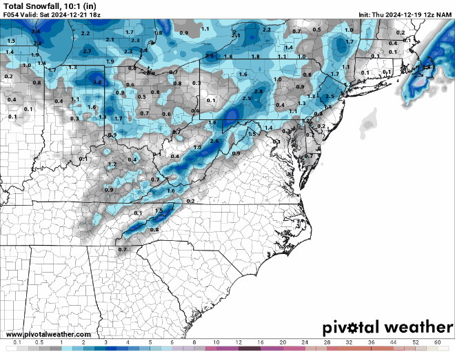
If the 01Z HRRR (below) and RAP and the 0Z NAM (below) are right, we're going to get another 1-2" in most of CNJ/NNJ/NYC and even down to Philly and parts of SNJ.
-
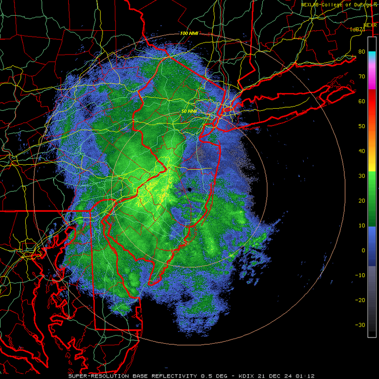
Ok, kids, game on! We got 3/8" in the last hour for an hourly rate of - wait for it - 3/8" per hour, lol. Snowing moderately at 33F and accumulating everywhere except on paved surfaces - nice dendrites, so the snow growth aloft must be nice in the dendritic growth zone. Radar looks good for awhile, so 1-2" is certainly in reach. Let's see how it goes. My wife and I just went for a very nice walk outside - it's just gorgeous out there!
-
This might count as rubbing it in, lol.
-
Any reports from Philly, proper, yet? Haven't noticed any in this thread. Thanks.
-
Any snowfall reports from Philly? Heard it's snowing hard, as per the radar, but no idea if it's accumulating (a friend in center city said not on the streets yet, but that's not a surprise).
-
Looks like you will be right - just hoping, selfishly, that the Edison area at least gets in on some of it - starting to get a nice batch here with light to moderate snow again for the first time in a couple of hours and starting to accumulate at 33F.
-
Incoming! For 95 corridor in CNJ...
-
NWS updated discussion sounds like the inverted trough feature will be from SENJ to Philly and up to the Lehigh Valley, although they're not changing snowfall forecasts yet. National Weather Service Mount Holly NJ 639 PM EST Fri Dec 20 2024 .NEAR TERM /THROUGH SATURDAY/... As of 635 PM, an upper air analysis showed a trough axis nearly over our area with strong vorticity advection moving through. This is helping to provide ample forcing for ascent and widespread precipitation across most of the area. It has been drier down in Delmarva but some radar returns continue to develop there. Much of the precipitation is in the form of snow as cooling continues to arrived from the west, although some lingering rain closest to the coast which should mix with and change to some snow at times. Snowfall amounts have been as high as 1 to nearly 2 inches in parts of the Lehigh Valley area so far. There is a weak surface trough from southeast New Jersey northwestward to near Philadelphia then into the Lehigh Valley. It is roughly in this zone where additional snow may become more focused through the overnight. Overall, no significant changes made to the forecast with this update.
-
Well, let's hope this thing backfills as forecast for the 95 corridor. All we need is 3-5 hours of 1/4-1/2" per hour decent snow at around 32F to get 1-2". Is that so much to ask for lol?
-
There's a reason he's 5-posted, I guess, lol. When the forecast is for about 1" and the uncertainty on that forecast is probably about +/-1", then one should expect 0-2", so 1/2" would be well within expectations. Funny how nobody says boo when there's a rain forecast for 0.1" and one only gets 0.05" - nobody freakin' notices.
-
just starting to accumulate a little bit on the colder surfaces here (on the car and the deck chairs, but not the deck yet). With the temp down to 33F and at least steady light snow, I think we'll start accumulating on all but paved surfaces soon.
-
Never measure on paved surfaces as they often retain too much heat and have some melting. That's why NOAA recommends a white snowboard (to minimize board heatup and melting from insolation) placed on the ground, away from obstructions, but if you don't have that, any colder surface will do (cartop, deck, or even grass, although grass can inflate amounts especially if the snow is fluffy). And one isn't supposed to measure more than 4X per 24 hours, but one should, if possible, measure after a precip change from snow to rain, before compaction/melting (also sleet counts, but again, clearing the board after a change from snow to sleet is ok and the two amounts are added; freezing rain should not be counted). https://theconversation.com/how-is-snowfall-measured-a-meteorologist-explains-how-volunteers-tally-up-winter-storms-175628
-
NWS updated their snowfall map for the region, extending the 1-2" swath through all of CNJ and NENJ and into NYC, with 2-3" still forecast along/N of 78 (and NW of 287), as the interaction between the clipper from the west and the bombing low well off the DelMarVa is expected to give most of us (except probably NYC eastward) a little bit more precip from this evening through about sunrise, with most of that being snow as temps drop to around 32F for folks along/near 95 by late evening, allowing accumulations, probably even on untreated roads in most locations. And Lee Goldberg also expanded his 1-3" swath to include all of CNJ (mostly 1-2" really), except areas east of the Parkway in Monmouth/Ocean and east of the NJTPK from about Carteret to the GWB, where he has about 1" or so and less for NYC/LI (due to less precip). Not a major snowstorm, but people should certainly be careful on the roads tonight and tomorrow morning, should we get forecasted snowfall amounts. Stiil snowing mostly lightly here with no more accumulation (maybe 0.1" so far), as temps are still 34F, but the sun is setting, so temps should drop towards 32F for the 95 corridor by 9-11 pm, allowing any snow to fall to accumulate after that, whereas accumulation will be more intensity dependent from now until then (and with light intensity, probably not much accumulation along/near 95 and SE of there until mid/late-evening). Would love to get at least 1" just because and an overperforming 2" would be amazing and possibly enough to last through Christmas Eve given how cold it will be until then.
-
Had occasional very light snow/rain mix from about 10 am to 2 pm with no accumulation at 36-37F, but we've had more light-to-moderate snow since then and temps are down to 34F and we're getting some stickage on cars/grass and I was even able to make a snowball, lol. Maybe 1/8" so far. I'm assuming this will continue without much accumulation until at least early evening when temps drop a bit more, plus there won't be any indirect sunlight impact (much less on the shortest day of the year, but not zero, especially with temps above 32F and lighter intensity). Sticking with my 1.25" snowfall guesstimate for the event.
-
Doubt very much that NYC gets shut out... less, maybe than other locations but not shut out.
-
We have almost the exact opposite of what we had ~24 hours ago with regard to the NBM, as it's showing <1" for just about all of CNJ/NENJ/NYC/LI, while every major global/CAM model so far (CMC, GFS, HRRR, NAM, RDPS, ICON and HRDPS) is showing 1-2" with 3" spots for just about everyone N of 276/195 in PA/NJ/NY. Last night we had much more snow on the NBM than shown on most of the major models. Going to be interesting to see what the NWS and others do with this info, especially if the Euro/UK are similar - my guess is the NWS will expand their 1-2" forecasts down to the 95 corridor in NJ/NY - we'll know soon.
-
Why are you only comparing through 4 am, when the snow isn't over until maybe 10 am or so? 18Z NAM is still less, but not as significantly so.