

RU848789
-
Posts
4,002 -
Joined
-
Last visited
Content Type
Profiles
Blogs
Forums
American Weather
Media Demo
Store
Gallery
Everything posted by RU848789
-
Sun angle matters any time of year - it just matters less the closer one is to the solstice, as there is a continuum of melting rates as the sun angle increases continually away from the solstice. I've always guesstimated melting rates (on grass at midday, for example at 32F) as follows: from very low (<0.05"/hr?) within 1 month of the winter solstice to moderately low for 1-2 months away from the solstice (0.05-0.1"/hr?) to moderate for 2-3 months from the solstice (0.1-0.2"/hr?) to fairly high for 3-4 months from the solstice (0.2-0.3"/hr)?, i.e., from late March thru late April. These rates are likely doubled for pavement. It's not like I've measured these formally, but these are my guesstimates from close observations over decades and they could be off significantly, although directionally they make sense. High snowfall rates can always overcome any melting rate through when snow is likely to fall (late April), even on pavement and remember, once snow starts accumulating, melting rates drop substantially, since the melting before accumulation is coming from the sun's UV rays warming the ground, while after accumulation starts, subsequent snowfall is falling on 32F snow, by definition, greatly decreasing melting rates (there is a minor melting component from the air temp if above 32F, but heat transfer from the air is about 23X less than from a liquid or solid).
-
Think that's always been the case for this one, at least south of 78 or even south of 80. Just want to see a few more inches and get the seasonal count up...
-
Haven't seen updated maps yet, but the NWS-Philly AFD is predicting more than this morning. Area Forecast Discussion National Weather Service Mount Holly NJ 336 PM EST Thu Feb 13 2025 SHORT TERM /FRIDAY NIGHT THROUGH SUNDAY/... To start the day Saturday, a large area of low pressure will be centered near Oklahoma with the systems warm front extending well north and east into Indiana and Kentucky. As the warm front approaches, expect clouds to quickly lower and thicken with precipitation developing over the area west to east most likely through the early to mid afternoon timeframe. This is a slightly later onset than previous thinking as it will take some time for dry air in the low levels to become saturated enough for precip. While the inland track of the low will ultimately put the area on the systems warm side, indications are there will be enough cold air at the onset for a front end "thump" of snow that could affect areas even as far south as the I-95 corridor. As such, expect that the urban corridor will see precipitation start as snow Saturday afternoon with the potential for an inch or two of accumulation before a change to rain occurs here from south to north through the late afternoon into the evening. Farther north, there will be greater concerns for wintry precip lasting further into Saturday night. Getting up towards the I-78 corridor, expect snow to mix with and change to sleet and freezing rain into Saturday evening with the potential for several hours of a wintry mix before an eventual change to rain. It is this zone and areas northward where 2 to 4 inches of snow and sleet is expected with the potential for a tenth to a quarter in of ice accretion to follow.
-
Most of the 12Z models a bit snowier and further south (including the Euro) with at least minor snow and with more snow to the north too, before the changeover to rain (and probably ice then rain well to the north). As long as we don't see a much faster changeover to sleet, like the two recent mixed events. Potential for a few inches even in CNJ/NYC before the rain, although with borderline temps during the day, accumulation might only be on colder surfaces, especially if rates aren't that high (there is always a sun angle issue - it's just at a minimum at the solstice and continually increases away from the solstice).
-
First snowfall map up from the NWS-Philly for Saturday pm. Looks more like the Euro (the least snowy model) than the GFS (most snowy model), obviously, as per below. Lots of rain to follow for everywhere south of 80 and maybe even up to 84, but as Walt has said, the cold air could hang on pretty long towards 84 and icing could become an issue.
-
Thought the NWS forecast and most of the models yesterday, apart from the HRRR, did pretty well - not perfect, but pretty well. The estimated snowfall map and the NWS forecast from the 4 am package yesterday for much of the region from DC/Balt through Philly/NYC and up into the Hudson Valley/CT are attached; I like to use the NWS forecast from about 12 hours before the event starts to evaluate their forecast, as that's really when most people are committing to actions if needed. The NWS forecast was excellent along/SE of 95 and for areas that got <1" and was decent, but a bit overdone for folks between 95 and their 1" line, at least from Philly to NYC. For giggles, I included yesterday's 18Z HRRR, NAM, and Euro, as 18Z was the last model suite that came out before the storm started. The Euro/NAM were quite good (and earlier in the day, also, as were most other models), while the HRRR way underdid snowfall amounts (and consistently did so); the NWS was right to ignore it as an outlier (with good rationale, as well explained by Upton), as did most on the board.
-
Selected reports, which looked likely to be taken near/after the snow stoppedNew JerseyCape May 7.8"AC Intl 6.5"OC 7.0"Galloway Twp 8.0" (most I've seen)Mt. Holly 3.0"Glassboro 3.1"Blackwood 3.7"Brick 5.8"Forked River 5.0"Hamilton Sq 1.9"Jamesburg 2.0"Basking Ridge 2.0"EWR 1.2"Aberdeen 4.0"Wall Two 4.3"PennsylvaniaPhilly Intl Airport 2.6"Norristown 2.7"Langhoren 1.8"New YorkCentral Park 1.4"LGA 1.2"JFK 1.5"
-
The last 45 minutes of light snow did give us another 0.1" to bring the final storm total up to 2.0", as it's down to flurries now and there don't look to be any more bands coming. Was a bit less than my 2.8" prediction and the NWS prediction of 2.4" for Metuchen, but that's fine as I got to enjoy a really pretty snowfall; this brings our seasonal total up to 14.8", which is only a couple of inches behind where we should be, on average. Time to go shovel, which I love to do in the middle of the night when there's not a soul around. Edit - 30 minutes to shovel - way easier than the 2 hr shovel for Saturday's storm, which was 1.6" in depth vs. the 2" of depth tonight - that's why it's all about the mass, as tonight's mass was about 1/3 that of Saturday's.
-
Been light snow for the last 15-20 minutes, but the radar would make one think it's just some flurries. I'm thinking we've likely gotten that additional 0.1" to get to 2.0", but will wait until the snow stops before taking a final measurement - should be in the next 15-20 minutes.
-
Wow, it held on for a good half hour of moderate to heavy snow through about 3:05 am and as of 3:00 am, we're up to 1.9", as we got 1/4" the last hour.. It's been snowing more lightly to moderately since about 3:05 am and it's possible we'll eke out another 0.1" to get to 2.0" for the storm. Temp is at 30F still.
-
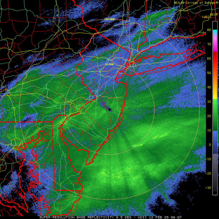
Well, that lull ended up hurting and that big blob aimed at us kind of disintegrated so we only got 0.15" the past hour, bringing our total up to 1.65" as of 2:00 am; temp is still 30F. Radar, in general, shows the back edge of the decent precip in Bucks/Montco, but it does look aimed at us so maybe we can eke out enough to get to 2", but I'm not counting on it. There's also always the possibility we can pick up another 0.1 or 0.2" after that from some lighter snow showers.
-
Forgot to post here, but As of 1 am, we have 1.5" of snow for another 0.3" the last hour and despite being in what looks like a radar lull, it's still snowing close to moderately (the small flakes might not be showing up great on the radar) and it looks like a healthy blob of snow is aimed at us and entering Somerset County right now. Hoping that batch can put us over 2". Still 30F. Just walked around a bit and threw some snowballs - the snow packs decently as it has some moisture, but it's nowhere near wet or slushy. Beautiful snowstorm even if we don't get crushed. Any reports from Philly?
-
As of 1 am, we have 1.5" of snow for another 0.3" the last hour and despite being in what looks like a radar lull, it's still snowing close to moderately (the small flakes might not be showing up great on the radar) and it looks like a healthy blob of snow is aimed at us and entering Somerset County right now. Hoping that batch can put us over 2". Still 30F. Just walked around a bit and threw some snowballs - the snow packs decently as it has some moisture, but it's nowhere near wet or slushy.
-
As of 12 am, we have 1.2" of snow for 0.3" the last hour and it's still snowing moderately, but we're missing the heavier bands just to our SE by 5-10 miles, so at this point, thinking about 2", assuming 3 more hours of this, unless we finally get a few heavy bands. 2" reported in Hazlet and 2.8" in Howell and oddly 2" in Basking Ridge, which was supposed to get less than here, but you never know where the best banding will set up. 1" in Piscataway and 4" in Toms River.
-
Haven't given a single thought to future rain. Get outside man and enjoy the snow while you can - it's freakin' gorgeous out there right now.
-
As of 11 pm we have 0.9" of snow for 0.3" last hour. Snowing close to moderately now; still mostly small flakes though, but guessing maybe 11-12:1 ratios (will probably measure this one - the snow/sleet/ZR mess was impossible lol). Radar still looking very good for most of NJ, except Sussex/Warren, which is no surprise, and in NYC/LI. 30F outside and just went for a drive for fun and to get some groceries and all of the untreated side roads are snow covered, while the county roads are slushy to wet, as they've been treated and Route 1 and 287, which get heavily treated and have a lot of traffic, are just wet. This shows the contrast to Saturday, where 287 and 1 were a snowy/sleety mess, completely covered, as that precip was heavier and sleet simply doesn't melt as fast from air temps or salt (low surface area). As I've said many times, an inch of mostly sleet is much more impactful than an inch of snow.
-
As of 10 pm, we have 0.6" of snow for exactly 1/4" this past hour also, with snow continuing to fall between lightly and moderately at 30F. Radar has filed in nicely to the SW and NW, so folks in the rest of CNJ/NNJ NW of about 202/287 ought to at least get an inch or so from this storm. Not sure I'll make it to my 2.8" prediction, but I think 2+" is very attainable, with another 4-5 hours of decent snowfall likely and maybe a bit heavier than so far, as has been forecast from 10 pm to 2 am roughly.
-
Radar looks to be filling in in Montco/Bucks a bit, which "should" make it into Somerset and probably eastern Hunterdon and then hopefully Morris.. NWS standing by their forecast, as per below, but they've been wrong before... Area Forecast Discussion National Weather Service Mount Holly NJ 910 PM EST Tue Feb 11 2025 .NEAR TERM /THROUGH WEDNESDAY/... 910 PM...Snow continues to fall over roughly the southern 60 percent of the forecast area with the heaviest continuing to fall over portions of Delmarva into southern NJ. Portions of Sussex County Delaware have already seen over 6 inches. All in all, no major changes to the forecast with the mid evening update. The storm total snowfall forecast remains similar with 4-8 inches of total snow expected in areas where the Winter Storm Warnings remain in effect, and as referenced above with the frontogenetic band, likely an area of localized maxima above 8 inches over southern interior portions of Delaware possibly extending into portions of the MD eastern shore Counties. However extreme southern portions of DE along with the Delware Beaches zone will likely see some rain and sleet mixing in at times. Areas within the Winter Weather Advisory across northern DE, southeast PA, and Central NJ are still expected to receive 2-4 inches of total snowfall. Across northeast PA and into northern NJ, snowfall totals up to 2 inches are expected. The majority of the snowfall will be this evening and early on tonight.
-
As of 9 pm we have 0.35" of snow on the ground for exactly 1/4" the last hour, with snow falling between lightly and moderately at 31F. Everything is covered and slippery. We're still not far from the NW edge of the accumulating snow - not sure if folks in Somerset or especially Hunterdon or Morris are getting much. Heavy band just went through Mercer and southern Middlesex, but missed to my SE.
-
As of 8 pm, we have 0.1" otg (just about 1/4"/hr rate) at 31F and snowing lightly to moderately - nice dendrites. The radar shows the decent snowfall rates falling off quickly about 10 miles NW of here, so this could be a close call all night unless the radar follows the NAMs and some other models and fills in towards Sussex/Warren counties for awhile.


