

RU848789
-
Posts
3,615 -
Joined
-
Last visited
Content Type
Profiles
Blogs
Forums
American Weather
Media Demo
Store
Gallery
Everything posted by RU848789
-
Snowfall NYC subforum Jan 6 and OBS if needed
RU848789 replied to wdrag's topic in New York City Metro
2009-2010 was way better than 2010-2011 for me, with about 60" vs. about 40", respectively (similar in NB), whereas for CPK 2010-2011 had 61.9" vs. 51.4" for 2009-2010. For 2/25/10 we got about 19" here. -
Snowfall NYC subforum Jan 6 and OBS if needed
RU848789 replied to wdrag's topic in New York City Metro
Ok, every global has bumped up snowfall amounts at least a bit, so CNJ is not shut out on any of them, although we're only talking 1/2-1" for most with up to 1.5-2" as one nears 276/195 - and Philly gets at least 2" on all of them (except the UK which is still an outlier but not nearly as much as it was). Point is this appears to be some convergence with the mesos/CAMs which still mostly show more, especially the HRRR/RAP. At this point, it's time to make a guesstimate, so I'm going with 1.5" at my house in Metuchen, as I like the trend on the globals and think the mesos/CAMs might do better on this storm. Unfortunately <1" is still on the table, but so is 2-4", at my house and for most of CNJ, especially towards 276/195. -
Snowfall NYC subforum Jan 6 and OBS if needed
RU848789 replied to wdrag's topic in New York City Metro
Most of the globals have moved north with their precip shields at least a bit (especially the UK), so maybe we're seeing some convergence between the two camps finally. Let's see what the Euro says...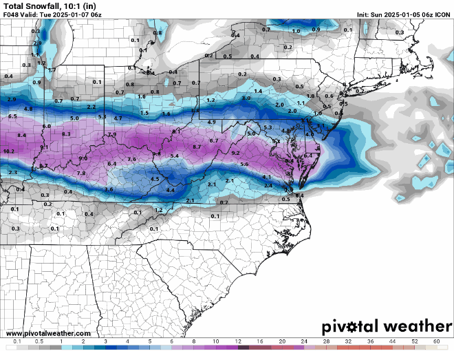
-
Snowfall NYC subforum Jan 6 and OBS if needed
RU848789 replied to wdrag's topic in New York City Metro
6" in Metuchen on 2/6/10. Here's part of my recap from that one...(I post a lot more elsewhere, lol, but you kind of asked). Ok, here's the recap. Well, I obviously spoke too soon yesterday morning (may need to get myself a "Jump To Conclusions" welcome mat - name that movie), as the next 5-7 hours brought the heaviest snow of the storm to many places including finally punching through the dry/cold air in most of Central Jersey, so that I at least got 6" of snow in Metuchen and everywhere south of Central Jersey kept getting hammered, meeting and even exceeding the amazing accumulation forecasts. The only area that most of the pros "busted" was NE NJ, NYC (except SI) and LI and anywhere north of there. However, overall, the forecasts were pretty damn good for a perhaps the most complex snowstorm to hit this area in a long time. · NW NJ (Warren/Sussex/Morris), Bergen, Passaic, Essex and Hudson Counties, NYC, LI, CT and everywhere north of there essentially got shut out, except for an inch or two of snow in the southern parts of a few of those counties. There was nearly mass weenie suicide on the NYC metro thread on Eastern. · Central Jersey from about 78 down to a line from Trenton to Asbury Park generally got 6-12" of snow, except close to NYC, where most of Union County and most of Staten Island got 2-4" of snow; the larger amounts were to the south, of course. · Interestingly, areas in PA that are at the same latitude as most of Central Jersey (i.e., Bucks, Berks and northern Montgomery Counties), got much more snow (12-18"), as they were further away from the "confluence" of incoming dry/cold air that squashed accumulations in NYC. · Between the line from Trenton to Asbury Park and a line from Philly to Toms River, most locations got from 12" to 20" of snow and from Philly to Toms River and points southward, most locations got 20-30", which is an enormous amount of snow · The jackpot for snow accumulation was from about Philly (28") and adjacent South Jersey and the SW suburbs of Philly down through most of DE, the DC-Baltimore area, NE MD and northern VA (and even WV) where 24-36" accumulations were observed. · So how's this for a gradient? Simply moving down I-95, here's the progression of snowfall: 0.0" in Central Park, 1/2" in Newark, 1" in Elizabeth, 4" in Rahway, 6" in Metuchen, 8" in New Brunswick, 13" in Trenton, 19" in Mount Holly, 28" in Philly and 30" in Baltimore. Unprecedented, especially the 0-28" over the ~90 miles from NYC to Philly. -
Snowfall NYC subforum Jan 6 and OBS if needed
RU848789 replied to wdrag's topic in New York City Metro
GFS is as close at 12Z to 6Z as it could be, so no movement there...posting Kuchera map given Walt's comments on any banding likely having good ratios aloft (which probably is close to Kuchera's greater than 10:1 ratio based on max column temps). -
Snowfall NYC subforum Jan 6 and OBS if needed
RU848789 replied to wdrag's topic in New York City Metro
I post on the 33andrain Discord, but also find it harder to navigate/follow, plus it has a ton of useless banter mixed in, but it does have more meteorologists posting model play by play and other commentary, which I do like. And I also post a lot more on FB and a couple of other boards. And great points on the NWS - feel similarly, although I also dislike the harsh bashing they get when a forecast is wrong or even just a bit off, as many simply don't understand how complex the weather is and that it's still impossible to accurately predict precip/snowfall (especially in mixed precip events) several days in advance and even, sometimes 12 hours in advance, lol. It's not that they're bad scientists - this is just really hard stuff to get right. -
Snowfall NYC subforum Jan 6 and OBS if needed
RU848789 replied to wdrag's topic in New York City Metro
And, of course, the ICON jumps north, so maybe the two camps are going to just move towards each other. That would at least be better than a complete shutout for areas N of 276/195.
-
Snowfall NYC subforum Jan 6 and OBS if needed
RU848789 replied to wdrag's topic in New York City Metro
The NAMs and HRRR moved significantly south at 12Z - see my post a few posts ago. Fat lady is warming up. -
Snowfall NYC subforum Jan 6 and OBS if needed
RU848789 replied to wdrag's topic in New York City Metro
12Z NAM and NAM3K and HRRR backed off a fair amount on snow, especially towards Philly, although they're still a lot snowier than most of the globals. Wonder if the mesos/CAMs are starting to cave to the globals today at 12Z.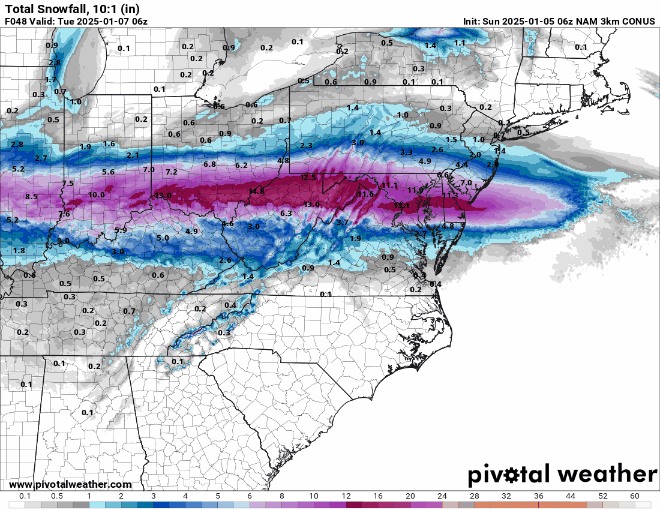
-
Snowfall NYC subforum Jan 6 and OBS if needed
RU848789 replied to wdrag's topic in New York City Metro
Very interesting that the NWS bumped snowfall back up for areas N of 276/195, including CNJ/NNJ/NEPA/NYC, with their 4 am forecast, as per the map below; it's fairly similar to the Channel 7 forecast. Their 1" line moved from just south of 78 to about 80, except for NENJ (Union/Essex/Hudson) and NYC/LI, where <1" is forecast, and their 2" line is now from about Frenchtown to Sea Bright and the 3" line is along 276/195 (was 10-15 miles south of there); south of that 3" line very little change. The NWS discussion doesn't have the usual "model discussion" section at 4 am. In contrast, TWC has the 1" line along 276/195 with <1" north of there and the 3" line from about Wilmington to AC, as do others, while News12NJ is between the two camps with their 1" line from about Frenchtown to Sea Bright and their 3" line from Philly to LBI with 3-6" south of there. Bust potential is pretty high, IMO, as the global models at 0Z last night and 6Z this morning continue to show much less snow than this across the board, as all of you know, with generally <1" N of 276/195 and even only an inch or two for the Phillly/SNJ area; they must be leaning more towards the meso/CAM models, like the NAM3K, HRRR, RAP, SRERs, etc., which show amounts similar to the NWS map (or even more). From a meteorological perspective, this is a fascinating conundrum to have these two camps so far apart, but from a "client" perspective it's very frustrating to have such low confidence in the NWS forecast. -
Snowfall NYC subforum Jan 6 and OBS if needed
RU848789 replied to wdrag's topic in New York City Metro
Long range RAP anyone? Hey, if we're going to grasp at straws, at least let them be good ones, like this and the long range HRRR, lol. -
Snowfall NYC subforum Jan 6 and OBS if needed
RU848789 replied to wdrag's topic in New York City Metro
Yes it does. Nice to at least have the NAM/GFS and even the long range HRRR on the snowier side; maybe some of the others will want to join the party at 18Z.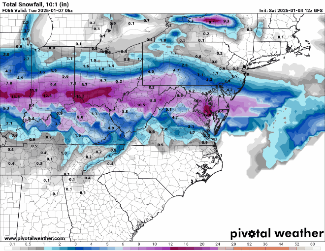
-
While this is obviously fantasy land as it contains a 2nd storm 14 days out, the first storm is now just 7 days away, which is transitioning from fantasy land to something that could have potential, as per the 24 hr snowfall map below - not that we'll get that much snow, but that perhaps there's a decent chance of a significant snowstorm next weekend.
-
Snowfall NYC subforum Jan 6 and OBS if needed
RU848789 replied to wdrag's topic in New York City Metro
Can you elaborate? Is this related to the conversation Walt, Mike Gorse and I were having over precip/snowfall discrepancies and the time-lagged NBM issue? I can't tell what you've highlighted. Thanks. -
Snowfall NYC subforum Jan 6 and OBS if needed
RU848789 replied to wdrag's topic in New York City Metro
SIAP (been playing at a disc golf tourney all day), but the NWS updated their regional snowmap (I love these as they show Mt. Holly and nearby adjacent areas). Clearly backed off for snow north of 276/195 in EPA/CNJ, especially N of 78 which is <1" but beefed snowfall up a bit for Philly/SNJ and south of there. Still lots of uncertainty and bust potential in both directions. -
Snowfall NYC subforum Jan 6 and OBS if needed
RU848789 replied to wdrag's topic in New York City Metro
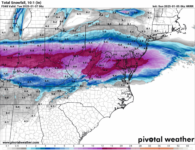
NAM moved a bit north not a lot (same for the NAM3K), but the bigger thing is it's the snowiest model and it did improve. ICON looks the same at 18Z and 12Z, but the HRRR, which did well with the two Dec storms, but did terribly with the SNJ storm yesterday, is pretty snowy. The RGEM is slightly less snowy with very little snow for Philly-AC even and northward. SREFs look great as always, lol.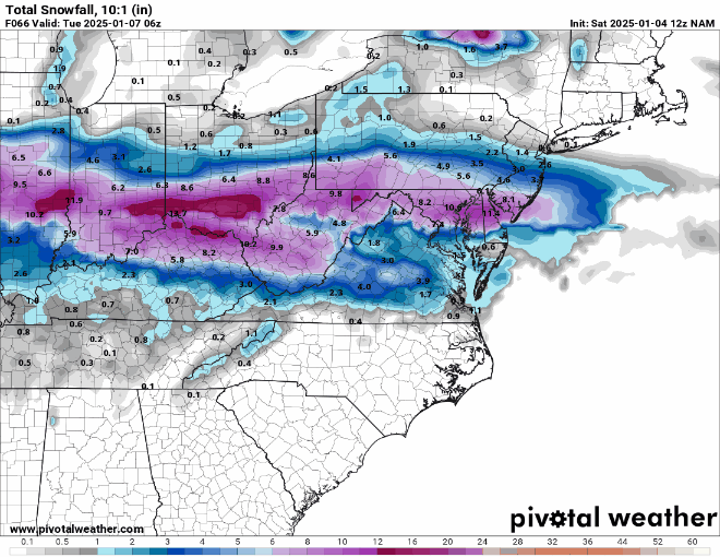
-
Snowfall NYC subforum Jan 6 and OBS if needed
RU848789 replied to wdrag's topic in New York City Metro
wow, even Philly gets screwed with essentially nada -
Snowfall NYC subforum Jan 6 and OBS if needed
RU848789 replied to wdrag's topic in New York City Metro
it's probably over for more than 2" for CNJ, but I'd still be happy with 1-2". There's still time for minor shifts back north to make that happen, as we're not that far off. CMC still has 1-2", GFS/RGEM have an inch, and NAM/ICON have an inch or so for the southern half of CNJ, plus there's the 2-4" on the SREFs. If we hadn't seen snowier solutions over the past few days and were magically transported to where we are now with no knowledge of the past, we might look at where we are now and say, hey, some minor to moderate changes get CNJ and maybe even NYC into at least a couple of inches of snow. The models don't "remember" previous runs and are independent events with new data every time (as far as I know). -
Snowfall NYC subforum Jan 6 and OBS if needed
RU848789 replied to wdrag's topic in New York City Metro
Did you see the key part of the Mt. Holly AFD where they talk about their reasoning for going bullish with the snow for CNJ/NNJ? Wish they'd come on one of these boards and clearly show what they mean by "looking at the overall atmosphere aloft including jet dynamics and mesoscale features." The biggest challenge that still persists at this time is with regard to the track of the surface low and where it will be as it crosses through the area. While the majority of ensemble guidance has shown a southern shift over the past 12-24 hours with QPF, looking at the overall atmosphere aloft including jet dynamics and mesoscale features, it seems that the overall consensus of the track seems to be too far south. Depending on the strength of the system as it approaches and confluence that lingers over the Northeast US, will simply determine how far north the snow shield reaches. Have started to see some waffling back and forth with the 12Z guidance, so don`t completely buy the entire southern shift. Unfortunately, there is still a lot of uncertainty amongst global guidance, where the greatest potential for higher-level impacts remains over the southern-half of the forecast area. -
Snowfall NYC subforum Jan 6 and OBS if needed
RU848789 replied to wdrag's topic in New York City Metro
Surprised at this, but more hopeful now, but also a bit skeptical...we'll see soon...see the part in bold, in particular for amounts, but to summarize here: 1-2" N of 80, 2-4" from 80 down to 276/195, 4-6" south of 276/195 with lollipops to 6-8 where the best banding sets up in SEPA/SNJ. I could certainly live with this. Edit: here's the NWS map for NWS-Philly and parts of adjacent offices. Nice. Area Forecast Discussion National Weather Service Mount Holly NJ 335 PM EST Fri Jan 3 2025 .SHORT TERM /SATURDAY NIGHT THROUGH MONDAY NIGHT/... Our attention then turns to the winter storm potential that will impact the Mid-Atlantic region late Sunday night through Monday, possibly lingering into Monday night. A potent shortwave ejecting out of the Rocky Mountain region will develop into a closed low as it slides across the Central Plains. This closed low will undergo cyclogenesis and lead to a surface low developing while tracking through the Central US on Sunday night. The surface low will continue to track due east crossing somewhere between the southern Delmarva and eastern North Carolina by Monday afternoon. The biggest challenge that still persists at this time is with regard to the track of the surface low and where it will be as it crosses through the area. While the majority of ensemble guidance has shown a southern shift over the past 12-24 hours with QPF, looking at the overall atmosphere aloft including jet dynamics and mesoscale features, it seems that the overall consensus of the track seems to be too far south. Depending on the strength of the system as it approaches and confluence that lingers over the Northeast US, will simply determine how far north the snow shield reaches. Have started to see some waffling back and forth with the 12Z guidance, so don`t completely buy the entire southern shift. Unfortunately, there is still a lot of uncertainty amongst global guidance, where the greatest potential for higher-level impacts remains over the southern-half of the forecast area. With all this in mind, the forecast this afternoon features a solution that incorporates warning level snowfall for areas around Philadelphia and points south. The highest snowfall amounts will end up being located within a frontogenetic band where SLRs will be locally higher under an area of enhanced snowfall. The confidence is rather low on where this FGEN band will set-up over the region though. Based on latest 700-850 mb frontogenesis progs, the greatest likelihood will be somewhere between the Philly metro and central Delaware. In fact, some of the hi-res guidance that has come in this afternoon shows a warm nose between 850-925 mb that creeps northward during the day on Monday into portions of the Eastern Shore of Maryland and southern Delaware. This would result in some potential mixing issues in the form of sleet and/or freezing rain which will drastically undercut snow totals, with the heaviest snow totals located just north of the mixing line. Upon discussion with neighboring offices and given the overall uncertainty, have opted to not issue any Winter Weather headlines with this forecast package. In terms of snowfall amounts, our initial forecast is for a 4-6 inch snowfall event for areas on a line from I-76 to I-195 and points south, including the Philadelphia metro. Within this area, will be a localized maxima of 6-8+ inches depending on where the frontogenetic banding sets up. Between the I-80 and I-76/I-195 corridor, expecting totals in the 2-4 inch range with totals less than 2 inches to the north of I-80. There will be a sharp northern gradient to the snowfall due to confluence and dry air off to the north, so some of these totals may be slightly too high. -
Snowfall NYC subforum Jan 6 and OBS if needed
RU848789 replied to wdrag's topic in New York City Metro
Thanks!! I tried looking through that website before and just now and maybe I'm just dense, but I couldn't find anything on the time lag nature of the inputs into the NBM, but I'll certainly take your word for it. A time lag definitely explains how the NBM output at a particular time can look more like the output from the models from 6 hours earlier rather than the models that run somewhat concurrently with that time, assuming that the NBM is not including those concurrent runs. And yes I do realize the shorter term/high res guidance does start getting incorporated as one nears an event. -
Snowfall NYC subforum Jan 6 and OBS if needed
RU848789 replied to wdrag's topic in New York City Metro
Just a minor shift south over the last 18 hours for the ICON.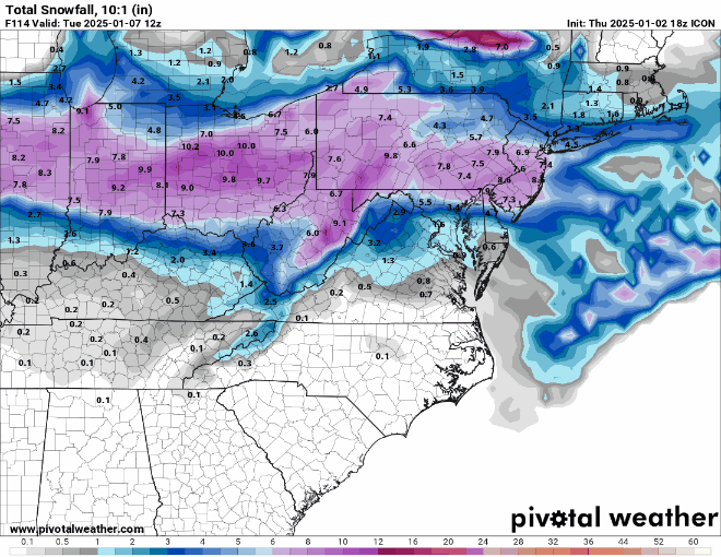
-
Snowfall NYC subforum Jan 6 and OBS if needed
RU848789 replied to wdrag's topic in New York City Metro
A couple of folks on 33andrain, including one met, have said that the NBM is time lagged, i.e., the 07Z NBM would only include model inputs through 0z and not the 06Z models. That would at least explain why the NBM snowfall for 07Z is greater than the 01Z NBM for areas N of Philly and much greater than the 06Z models would suggest, since they're generally much lower than the 0Z models were. To me, that makes the NBM a much less useful tool, if that's correct, as it would always be 6 hours behind. @MGorse- sorry to tag you again, but can you clarify if this is the case, i.e., what time model inputs go into a particular NBM run? I'd also be curious (see the quoted post) if the 12Z WPC QPF output is simply the 07Z NBM QPF field (they're identical), which is based on 0Z model data - that seems to be very old data, then.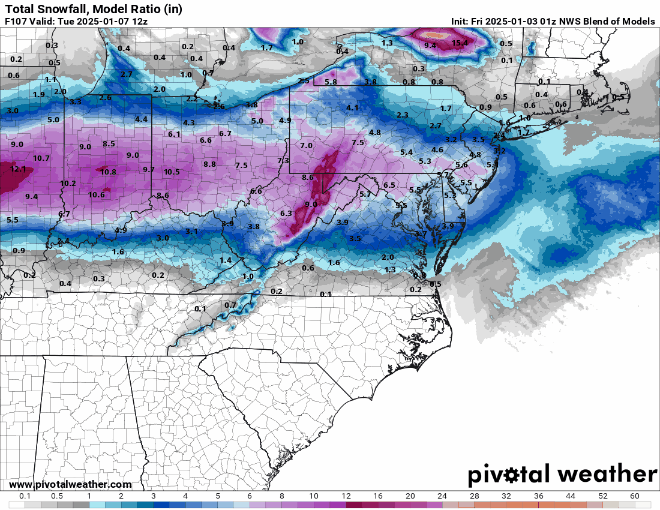
-
Snowfall NYC subforum Jan 6 and OBS if needed
RU848789 replied to wdrag's topic in New York City Metro
Would love to know how the NBM increased snowfall north of 276/195 up through 80 and even 84 at 07Z vs 01Z when every single model I have access to (GFS, Euro, ICON, and the ensembles for these) showed a significant decrease in snowfall for this area at 06Z vs 12Z. Only one model at 6Z, the ICON, has NYC at >1" (and the 0Z UK and CMC also had NYC at <1"), yet the NBM has NYC going from 2.4" to 3.5" from 01Z to 07Z. @wdrag? I know we had a conversation yesterday morning about inconsistencies with the NBM (between its high snowfall vs. the WPC low precip at the time), but this seems even worse. Edit: well, the 07Z NBM clearly thinks there will be 0.2-0.3" QPF for NNJ/NYC, as its QPF estimate is identical to the latest WPC QPF from 12Z today, below...
-
Snowfall NYC subforum Jan 6 and OBS if needed
RU848789 replied to wdrag's topic in New York City Metro
Ya never know. My guess is 75% of the area under advisories gets <1", but that a few locations that get sustained banding get up to 2", but those are very hard to predict.


