RU848789
-
Posts
3,615 -
Joined
-
Last visited
Content Type
Profiles
Blogs
Forums
American Weather
Media Demo
Store
Gallery
Everything posted by RU848789
-
Snowfall NYC subforum Jan 6 and OBS if needed
RU848789 replied to wdrag's topic in New York City Metro
Measured around 1:05 pm, thinking we were done, but 2 minutes later the snow picked up again and is still going decently, so might pick up another 0.1". It truly looks dry behind what we have now. My house is about 1/2 mile NW of where 287 and the NJTPK meet, so whenever someone says "north and west of 95" or "north of 287" I'm both, lol.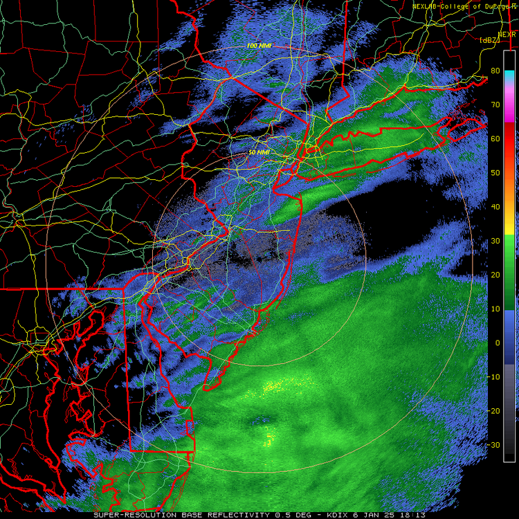
-
1/6 snowstorm - nuisance event or something bigger?
RU848789 replied to LVblizzard's topic in Philadelphia Region
As of about 1:05 pm, we're up to 1.1" and down to very light snow, with not much more on the radar to our west, so this might be it, unless we get a rogue band over the next hour or two. Not too far off my 1.5" prediction yesterday and more than I thought we were going to get around 9 am this morning when we got off to a slow start. Just enough snow for a few kids to sled on, although they left just before I got the latest pic below. -
Snowfall NYC subforum Jan 6 and OBS if needed
RU848789 replied to wdrag's topic in New York City Metro
1.6" reported in Basking Ridge - surprised they have more than us in Metuchen, but it did look like they had better bands, which is always a bit of a crapshoot. Back to moderate snow again and for the next 10-15 min I think - could be about it, but might get us to 1". -
1/6 snowstorm - nuisance event or something bigger?
RU848789 replied to LVblizzard's topic in Philadelphia Region
As of noon, we're up to 0.8" as that last ~40 minutes was pretty good snowfall, but we're back to very light snow. Could maybe squeeze out another 0.2" to get to 1", but not sure. Still gorgeous, though, as per the pic, which also shows the two roads I mentioned above, one brined and one not. -
Snowfall NYC subforum Jan 6 and OBS if needed
RU848789 replied to wdrag's topic in New York City Metro
As of noon, we're up to 0.8" as that last ~40 minutes was pretty good snowfall, but we're back to very light snow. Could maybe squeeze out another 0.2" to get to 1", but not sure. Still gorgeous, though, as per the pic, which also shows the two roads I mentioned above, one brined and one not. -
And at least the CMC isn't a whiff anymore...
- 993 replies
-
- 2
-

-
- metsfan vs snowman
- bomb
- (and 2 more)
-
Please sir, may I have some more?
- 993 replies
-
- 7
-
-

-

-

-

-
- metsfan vs snowman
- bomb
- (and 2 more)
-
Snowfall NYC subforum Jan 6 and OBS if needed
RU848789 replied to wdrag's topic in New York City Metro
Best snow of the storm the past 15 minutes - coming down moderately - not too much longer though on the radar... -
1/6 snowstorm - nuisance event or something bigger?
RU848789 replied to LVblizzard's topic in Philadelphia Region
In a bit of a lull now with very light, fine, pixie dust flakes falling, but radar looks nice approaching us from the SW, so should pick up soon. We're up to 0.4" as of 10:50 am (2 hrs) and it's still 26F. And brining works by the way for light snows like this: the street we live on, which was brined, is just wet, but the street that feeds into it is 100% snow covered. -
Snowfall NYC subforum Jan 6 and OBS if needed
RU848789 replied to wdrag's topic in New York City Metro
In a bit of a lull now with very light, fine, pixie dust flakes falling, but radar looks nice approaching us from the SW, so should pick up soon. We're up to 0.4" as of 10:50 am (2 hrs) and it's still 26F. And brining works by the way for light snows like this: the street we live on, which was brined, is just wet, but the street that feeds into it is 100% snow covered. -
1/6 snowstorm - nuisance event or something bigger?
RU848789 replied to LVblizzard's topic in Philadelphia Region
Grew up in Whitman Square - WTHS Class of 80. Hope you get to at least 3" down there. When I was a kid it always seemed like south and east of Philly - us - did much worse than north and west of Philly (usually due to mixing/changeover), but this could be your chance, lol. -
Snowfall NYC subforum Jan 6 and OBS if needed
RU848789 replied to wdrag's topic in New York City Metro
Yeah, I have friends in Mays Landing and Northfield who are getting heavy snow with a few inches OTG already. -
Snowfall NYC subforum Jan 6 and OBS if needed
RU848789 replied to wdrag's topic in New York City Metro
Yes, I edited my post, as I hadn't seen the 12Z NAM/RGEM/ICON all upping totals to 1-1.5" (and 2" in spots) for areas N of 276/195 up to 78, i.e., CNJ, so maybe I spoke too soon. -
Snowfall NYC subforum Jan 6 and OBS if needed
RU848789 replied to wdrag's topic in New York City Metro
13Z and 14Z HRRR, still have 1"+ for CNJ from 9 am through 2 pm. Not buying it. My guess is the Euro is going to end up being the model winner for the overall storm in the NE US at least, looking at its consistency for days showing a lighter event than other models and less than most forecasts, including the NWS. Edit - hadn't seen the 12Z NAM/RGEM/ICON all upping totals to 1-1.5" (and 2" in spots) for areas N of 276/195 up to 78, i.e., CNJ, so maybe I spoke too soon. -
1/6 snowstorm - nuisance event or something bigger?
RU848789 replied to LVblizzard's topic in Philadelphia Region
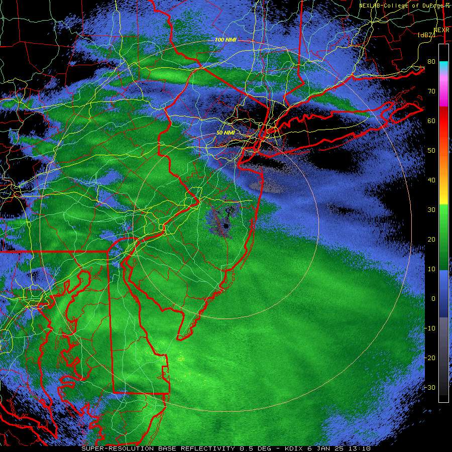
Been snowing lightly for about an hour and we have a whole 1/4" OTG as of 9:50 am, lol. NWS discussion said they're sticking with their forecast amounts, but I have my doubts for most of CNJ, especially the northern half towards 78, getting to 1" and for Philly getting to 3", looking at the radar, although it can always fill in more. It is covering all surfaces, which is no surprise at 26F, so paved surfaces are slick already. It is a very pretty snow - light and fluffy consisting of small dendrites. Edit: Well, all of a sudden, the 12Z NAM/RGEM/ICON came out, all upping totals to 1-1.5" (and 2" in spots) for areas N of 276/195 up to 78, i.e., CNJ, plus the 13Z and 14Z HRRR are showing 1"+ for CNJ from 9 am to 2 pm, so maybe I spoke too soon, especially as the radar in eastern PA from Philly to Allentown has blossomed and is heading our way - depends if it holds together or dries up/falls apart. -
Snowfall NYC subforum Jan 6 and OBS if needed
RU848789 replied to wdrag's topic in New York City Metro
Been snowing lightly for about an hour and we have a whole 1/4" OTG as of 9:50 am, lol. NWS discussion said they're sticking with their forecast amounts, but I have my doubts for most of CNJ, especially the northern half towards 78, getting to 1" and for Philly getting to 3", looking at the radar, although it can always fill in more. It is covering all surfaces, which is no surprise at 26F, so paved surfaces are slick already. It is a very pretty snow - light and fluffy consisting of small dendrites. -
Snowfall NYC subforum Jan 6 and OBS if needed
RU848789 replied to wdrag's topic in New York City Metro
Snow started here around 8:45 am and it's been light to almost moderate now with a nice coating on the ground. Very pretty and nice to not have to worry about melting. -
Snowfall NYC subforum Jan 6 and OBS if needed
RU848789 replied to wdrag's topic in New York City Metro
Looks like light to maybe moderate accumulating snow in green, which is advancing towards NENJ, so hopefully we can get a bit of snow this morning here.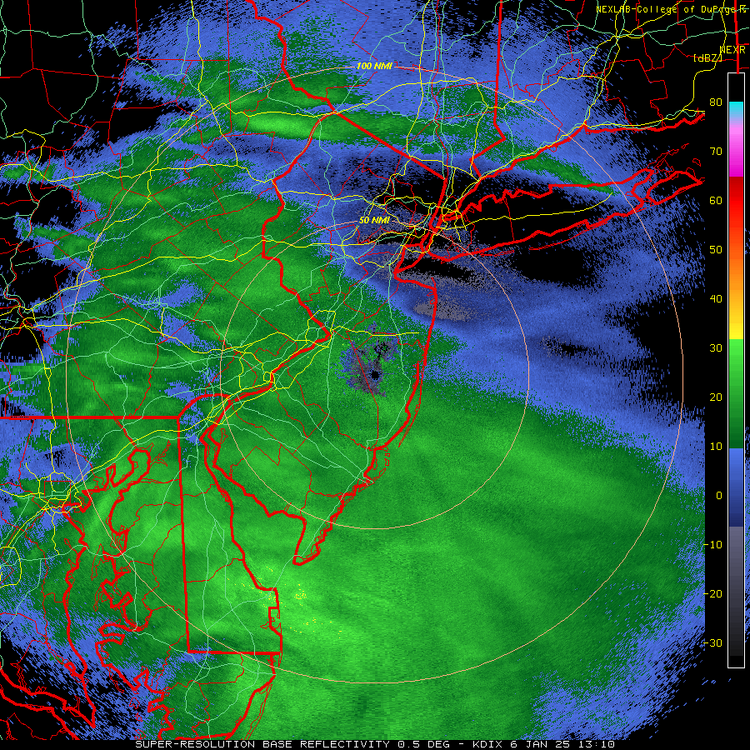
-
It's amped, all right, across the deep south, until it fizzles, just nowhere near us...
-
But if the GFS verified, could you imagine the wailing and gnashing of teeth from NYC to Boston if coastal DE gets 3 feet in one week and NYC to Boston get an inch or two?
- 993 replies
-
- 1
-
-
- metsfan vs snowman
- bomb
- (and 2 more)
-
Rain is never off the table 6 days out for us.
- 993 replies
-
- 1
-
-
- metsfan vs snowman
- bomb
- (and 2 more)
-
6" along 95 and a lot more towards the Jersey Shore at Day 6? Where do I sign?
-
Snowfall NYC subforum Jan 6 and OBS if needed
RU848789 replied to wdrag's topic in New York City Metro
You are mostly correct as my numbers were wrong. I actually had about 54" of snow in 2010-11, not 40" and I had 55" in 2009-2010, which is just barely more. I didn't start keeping a spreadsheet until about 10 years ago, so I was just looking at my weather email archives and missed a couple of decent storms in 10/11 and double counted one in 09/10. FYI, we had 23" for Boxing Day and 17.5" for 1/26, but also had 8" on 1/11, 3" on 1/20 and a couple of 1-2" events. I really need to go back and put these old winters in the spreadsheet, lol. Started doing the winter weather emails for every storm in 2000; was sporadic prior to that, usually just for the bigger ones. Below is the link to the NB snowfall history, which is always useful to check against for folks not far from there, like you and me, although note that their "total" column is the annual, not the winter total - nobody cares about the annual, lol, so one has to add up all the monthly rows to get the winter total. I just emailed them to see if they could address that. https://climate.rutgers.edu/stateclim_v1/monthlydata/index.php?stn=286055&elem=snow -
Snowfall NYC subforum Jan 6 and OBS if needed
RU848789 replied to wdrag's topic in New York City Metro
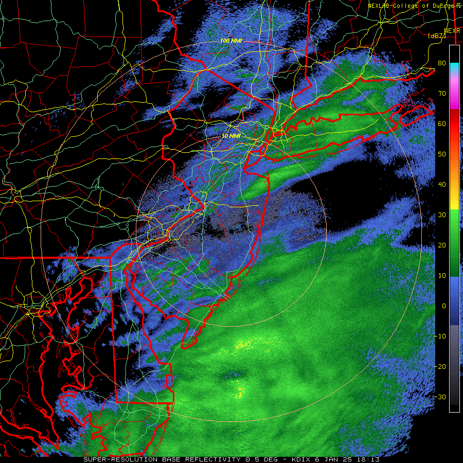
NWS updated 4 pm snowfall map is out and it cuts snowfall back just a bit vs. the 4 am package which did look a bit overdone, with the 1" line moving from about 80 to just N of 78 with only 1/2"-1" N of 78, including NENJ and NYC/LI. This also means CNJ is in the 1-2" range for the most part with the 2" line a little N of 276/195 and with the 3" line from just north of Philly to about Toms River, while the 4" line goes from just south of Philly to LBI. The forecast is for 4-6" south of there and then 6-8" south of a Wilmington to AC line. Looks like my 1.5" prediction for Metuchen is solid. No warning/advisory changes for counties along/S of 276/195. And bust potential has decreased, given the decrease in snowfall forecast by the NWS and increases in snowfall from the global models at 12Z and 18Z, so far, such that the globals are much closer to the still a bit snowier mesoscale/CAM models like the RAP/HRRR. However, <1" is still possible for CNJ, as is 2-4" if the storm under/overperforms and there are +/- 1-2" risks for SEPA/SNJ depending on how the storm performs. Almost radar time.