

RU848789
-
Posts
3,615 -
Joined
-
Last visited
Content Type
Profiles
Blogs
Forums
American Weather
Media Demo
Store
Gallery
Everything posted by RU848789
-
Yep, NJ has nowhere near the fire risk that Cali does - it's in the desert with incredibly dry fuels from months without rain (much more of a 6- month drought than we ever get), plus we don't ever get 5-10% humidity with dry wind gusts over 70 mph - the only time we get gusts over 40 or maybe 50 mph is from a storm bringing moisture. Throw in more density in their forested areas, plus the very rugged terrain and less water available to fight fires and there's the recipe for disaster. As we see almost every year, despite CA probably having the most advanced firefighting systems and personnel anywhere.
-
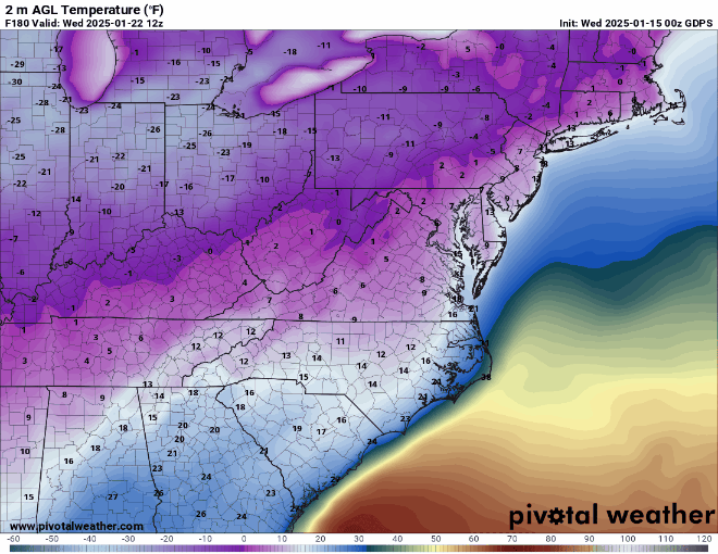
OMG, when was the last time we had snowed like that when it was in the teens for the entire event? And people know I don't like Kuchera, but hard to imagine not having 15:1 or higher ratios with snow crystal generation rates like that and low temps - but not the 40:1 ratios that Kuchera shows well NW of 95. Still 8 days out but pretty to look at...
-
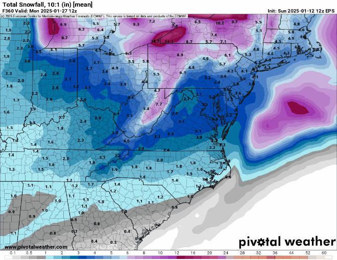
Not true - EPS mean shows a general 1-2" event around the 23rd and one would expect a decent amount less on an ensemble mean, which surely has quite a few misses, than an Op at 9 days out.
-
Schwing!
-
A very good article on what a cold and potentially snowy pattern is - and is not. Lots of chances coming up starting around 1/19 and going for a week or longer beyond that, but no guarantees of significant snow (just greater probabilities than usual). https://www.weathernj.com/another-snowy-pattern-detected/
-
Nice storm, especially with temps in the 20s and possibly 12-15:1 ratios (Kuchera shows ~15:1, but I don't trust ratios without knowing the situation in the DGZ where snow crystals/dendrites form)...just don't want to get rain on 1/19 and then have to wait until day 9 for snow, recognizing that counting on something at day 9 is a low probability usually...but I don't think the weather cares, lol.
-
Not sure why you're talking about the GEFS in reply to my post on the EPS.
-
On Pivotal Premium, I can see that the 06 Euro AI has temps in the 20s with 0.3-0.4" of precip falling on 1/20, which is pretty obviously snow, but they don't have any snowfall maps (same for the GFS AI) so I have to guess at snow - do you have snowfall maps and if so on which service? Just wondering if it's time to switch services. Thanks.
-
Nice despite the 0Z Op showing little snow...
-
Tell me the 18Z GFS Op is an outlier without telling me the GFS Op is an outlier, lol.
-
Really cool post by Tomer Burg on frequencies of DC-Boston megalopolis snowstorms of various sizes associated with Greenland Ridge decays (and afterwards) and other regime changes (including baseline no regime change). https://x.com/burgwx/status/1878092022277636324
-
Looks like a general 0.5-1.5" snowfall looking at the NWS accumulation map below, with a few places <0.5" and a few places more than 1.5", including Cape May once again being the NJ winner with 2.2"...so certainly not a whiff and even made it to minor territory (1-2") for many, which is a bit of a surprise. No NWS-NYC reports yet, other than 0.5" at Central Park.
-
Looks like a general 0.5-1.5" snowfall looking at the NWS accumulation map, below, with a few places <0.5" and a few places more than 1.5", including Cape May once again being the NJ winner with 2.2"...so certainly not a whiff and even made it to minor territory (1-2" - IMO) for many, which is a bit of a surprise. All gone from sunny spots, but still some in the shade, where we also still had some snow left over from Monday's event. No NWS-NYC reports yet, other than the 0.5" at Central Park.
- 993 replies
-
- 3
-

-
- metsfan vs snowman
- bomb
- (and 2 more)
-
Yes, but 5 years of data is not necessarily indicative of some sort of climate shift. The previous 3 March's (including one April snow) I got 11.8", 26.2" and 10.5".
-
As of 5:30 am we had 0.3" on the ground at 27F (fell back to sleep after that so didn't get to post it, lol) and as of 6:30 am we have 0.6" of very fine, fluffy pixie dust on pretty much all surfaces, so pavement is slick, but looking at the radar, it looks like that's about it for this "storm." We're up to 6.5" on the season. Very pretty little snowfall though.
- 993 replies
-
- 3
-
-
- metsfan vs snowman
- bomb
- (and 2 more)
-
Snowing lightly at 29F with an entire dusting otg.
- 993 replies
-
- 1
-
-
- metsfan vs snowman
- bomb
- (and 2 more)
-
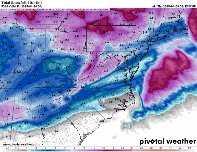
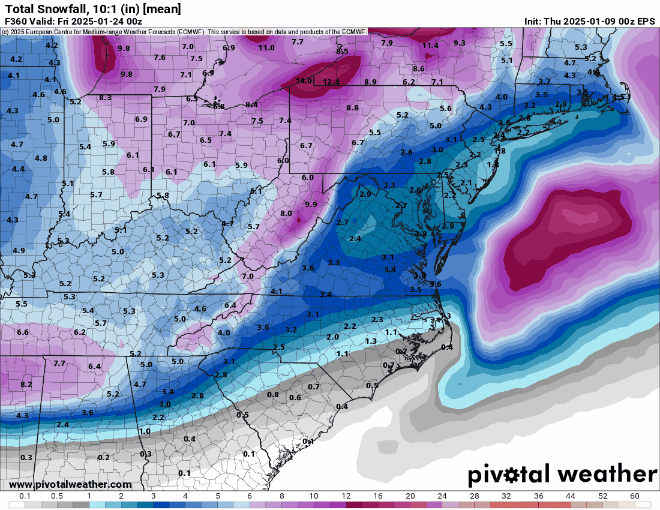
It's interesting to me to compare the Euro/EPS for the last two long range runs. At 0Z, the Euro Op showed significantly more total snowfall at the end of its run than the EPS mean did, while at 12Z the Euro Ops showed significantly less total snowfall at the end of its run than the EPS mean did. This implies that the Euro Op was likely a bit of an outlier in both cases, but this far out I'd rather have the EPS mean showing more snow than the Euro Op vs. vice-versa.
-
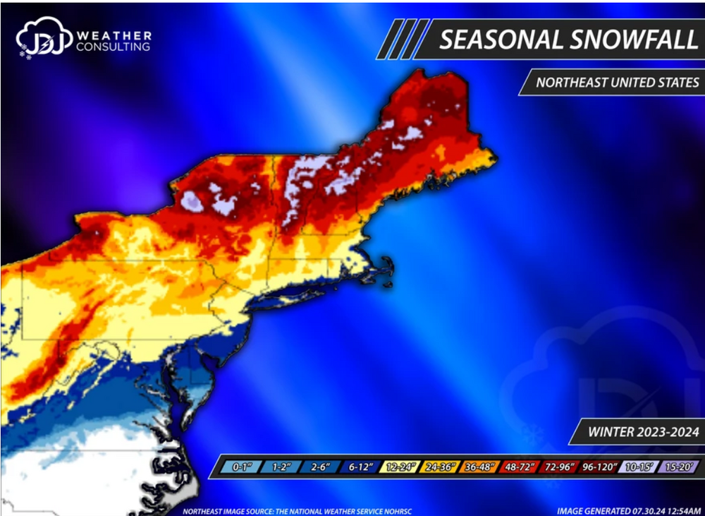
Great stuff, especially the page with graphics for NE US winter snowfall for the last 25 years, as per the one for last year, below. Would love it if there were a site like this for NJ/NY/PA. https://www.jdjweatherconsulting.com/northeast
-
My guess is nobody would be bummed with 1-2" (I'd be ecstatic as the NWS is predicting <1/2" for me), but <1/2" to just a dusting would be disappointing.
- 993 replies
-
- 1
-

-
- metsfan vs snowman
- bomb
- (and 2 more)
-
Our last hope, the NAM...
- 993 replies
-
- 2
-

-

-
- metsfan vs snowman
- bomb
- (and 2 more)
-
Was just looking at that. Another kick in the nuts for most of us not well N/W, with DC/Balt getting near 6" and nada for Philly-NYC-Boston. Verbatim, of course - good to have something that might turn into something good.
-
Not a fan at all - not a met, which isn't necessarily disqualifying, but he also clearly doesn't know his stuff...
- 993 replies
-
- 1
-
-
- metsfan vs snowman
- bomb
- (and 2 more)
-
I know it's 11 days out, so this is not meant as analysis, but to get a raging rainstorm near the end of this pattern would be a kick in the head with a metal boot...good to see a storm though, in the same timeframe as the Euro having a good storm (all snow).
-
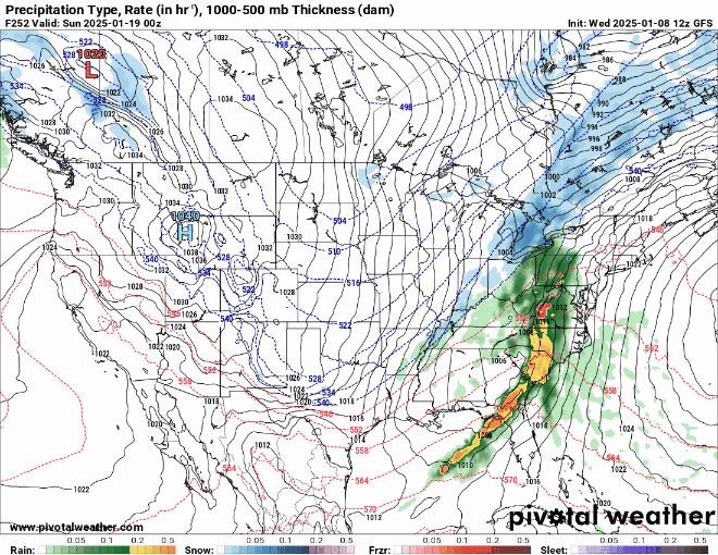
The 12Z models seemed similar to the 6Z models with some having <1" (and near zero for many locations) and some having 1" or so with a few spots to 1.5-2.0", especially SE of 95 towards the coast, so maybe an overall average of 1" just based on models and that's kind of what the 13Z NBM (model blend) is showing, below. However, the NWS-Philly put out a snowfall map around 10 am which, surprisingly, has roughly 1-2" from 276/195 up to 80 (less N of 80) and 2-3" south of 276/196, much like the 07Z NBM. I am kind of puzzled to say the least. It is consistent with their 4 am AFD, but one would've thought they might change their mind after seeing 0Z last night and 6Z this morning, but apparently not.
- 993 replies
-
- 1
-
-
- metsfan vs snowman
- bomb
- (and 2 more)
