SnoSki14
-
Posts
14,682 -
Joined
-
Last visited
Content Type
Profiles
Blogs
Forums
American Weather
Media Demo
Store
Gallery
Everything posted by SnoSki14
-
I see blocking for early April but not sure what happens after.
-
It's not that bad. Tomorrow looks nice, we'll probably see more 70s after the Arctic shot. Looks like an oscillating pattern into April. Temps underperforming today though. Only mid 40s. Temps will almost always underperform in easterly flow events in March-May.
-
Insane Antarctic warmth and nobody will notice because 0-10F is still perceived to be cold. Only when we get ridiculous heat in the states does anyone care. And for people to really notice we'd need a Pac NW style heat dome over the northeast.
-
March 2022 Obs/Disc: In Like a Lamb, Out Like a Butterfly
SnoSki14 replied to 40/70 Benchmark's topic in New England
I'd be willing to bet the blocking doesn't go away that easily and it ends up in the 40s with a cold & dreary easterly wind. -
That's way too early to say. If it showed snow at that range you would rightfully be skeptical. Models are also notoriously too quick to break down blocking. I take any model forecast beyond Day 5 with a grain of salt.
-
I'm not sure the pattern is favorable for snows but I continue to be impressed on the late March cold. Some guidance even shows us dropping into the teens with highs near freezing.
-
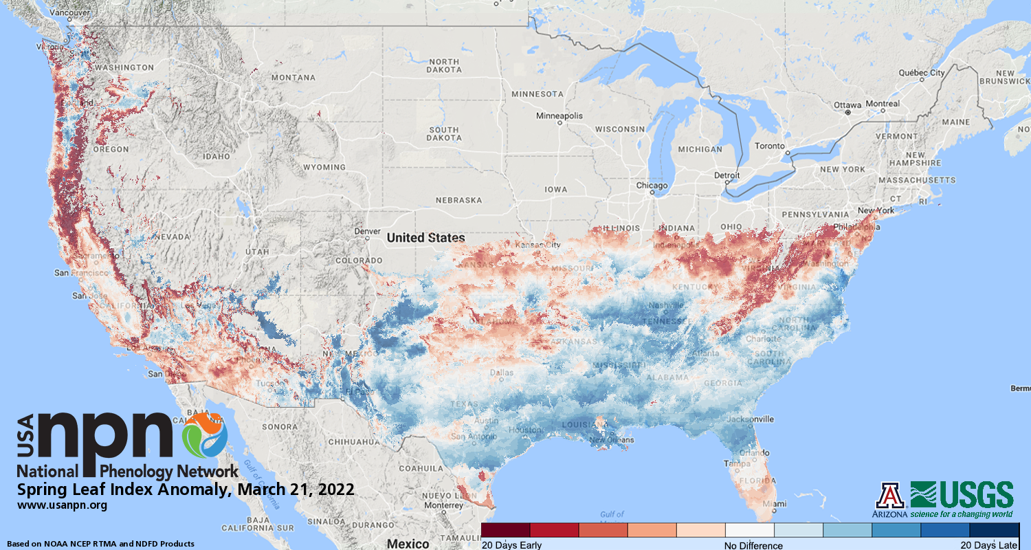
It's a rare legit cold wave in a sea of warmth. Early blooms likely to be affected.
-
I'd imagine this would have some effects on the early blooms we're experiencing. Looks like we're a couple weeks ahead of schedule.
-
12z EPS continues the strong blocking signal so I think it's legit. Spring blocking has been a common theme. I don't know how cold it'll get but it will def get unsettled for a time
-
Ensembles gradually trending stronger with the blocking so things should get a lot more unsettled. Still looks to be on the milder side with some cooler easterly flow days mixed in.
-
March 2022 Obs/Disc: In Like a Lamb, Out Like a Butterfly
SnoSki14 replied to 40/70 Benchmark's topic in New England
Not the most convincing blocking signal. EPS goes warm quickly by 1st week of April. -
EPS supports a cool shot but could easily moderate. Additionally cool shots by late March are not very cool. Still we likely haven't seen our last freeze.
-
80s incoming
-
You'd think so but we've seen even warmer Marches. If the cool down is mitigated a top 10 warm March is likely.
-
That will fuel more severe weather and flooding as well as additional tropical threats. I think the "dry summer" regime is dead for good.
-
So a combo of that plus those 100+ readings
-
This summer could be a brutal one rivaling the early 2010s imo. Nina sticking around + record SSTs offshore
-
Just more multi day 70+ in mid March with severe thunderstorm potential...nothing alarming here.
-
Keeping an eye on NAO/AO as they've been positive for months now. I think if they flip it won't be temporary. As long as it doesn't flip before May then spring should stay very warm
-
I see upper 70s on Friday. Very easy to beat guidance this time of year with bare trees.
-
It's almost 70F again and probably mid-up 70s by Friday. Sure it's nice now but this is very alarming. We're beating the newer records like it's nothing and it's only mid March.
-
In 15 days a cool day is basically today's high.
-
We're really tempting fate with these active hurricane seasons and strengthening SE ridging.
-
Temperatures will be a full month ahead of schedule and there isn't even anomalous ridging. It's scary how fast we've warmed. The consequences won't be good.
-
The only worry if we get an early bloom is a late season April cold shot. That's why it's good to wait until we're in the clear.