SnoSki14
-
Posts
14,682 -
Joined
-
Last visited
Content Type
Profiles
Blogs
Forums
American Weather
Media Demo
Store
Gallery
Everything posted by SnoSki14
-
I'm pretty confident we'll see a near benchmark track. The only concern is how far north the primary starts off. That's also the reason why I think we can rule out suppression. Also the trend is your friend

-
Euro still tucks, GFS shreds so take the middle solution I'm thinking it's gonna be a miller B with secondary off Delmarva. Coastal huggers are very unlikely in a strong blocking pattern.
-
If every model showed a bullseye today that would concern people. Frankly I'm glad there's a suppressed solution mixed in with the inland tracks
-
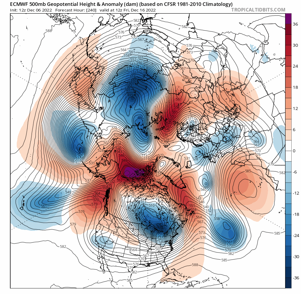
So what are your thoughts for the 16th.
-
Models are quickly moving in that direction. GFS has even stronger confluence on the 12z run. Pretty soon people will be worried about suppression however neutral to negative PNA argues against that
-
You're better off being more SW with Sunday. Now that strong blocking is in place it could continue ticking south as we get closer. Usually the opposite happens but not in this regime.
-
GFS ticking south and colder for Sunday. If trends continue we should def get snow to mix in and northern areas may even pick up a light accumulation. With strong blocking more south ticks are possible vs the usual last minute NW ticks
-
Which Decembers were able to hit -4 or lower at least one day
-
MJO is a non factor right now, probably for the better.
-
Plenty of time left for things to change but yes I agree.
-
The 16th storm could be it. West based blocking and excellent EPO conditions. A 50/50 type low ahead of it. It'll also follow a noteworthy -4 AO which has historically been a great snow signal for December
-
He's just playing devil's advocate
-
I think that could be our snowstorm
-
Primary gets pretty far north so you'll need the 50/50 like low to trend stronger and stick around longer otherwise any transfer will be too far north or inland.
-
Selfishly hoping confluence trends stronger and this goes slightly further south.
-
Nam looks nice for northern zones for this Monday
-
If people can't recognize the trend then it's on them.

-
Euro trending south with the primary for the 16th system. Still too far north for us but heading in a good direction
-
I'm not sure either the 12th or 16th will work out here. They are both embedded in the pattern transition phase. 12th doesn't have much room to amplify and the 16th has a primary that's way too far north to start. It's likely after the 16th where we get our favorable pattern. Getting the 16th storm to work out would be a major bonus Anything outside the 5 day period needs to be taken with a grain of salt. The model variations have been extreme this season
-
GFS showing the transfer now. Still not good for us but I don't see why it wouldn't continue trending
-
The 15th system will hit. Models trending towards redeveloper.
-
Nice to see threats showing up even if they aren't ideal just yet GEFS continue to make small improvements for our first system
-
A small piece of the PV has been shifting SW with each run so there is cold air to be found
-
Yes very odd but wouldn't surprise me if we get more of an RNA pattern for a time. My prediction is we get some kind of snow event or two (maybe significant) in the 12/12-12/22 period followed by a possible cutter or SWFE in the 12/24-12/28 range and then more favorable after the new year.
-
Tasty look and in a reasonable window Very stormy as well with an endless supply of disturbances likely coming in. It feels like models did a 360 turn to what they showed a several days ago but just slightly delayed