SnoSki14
-
Posts
14,682 -
Joined
-
Last visited
Content Type
Profiles
Blogs
Forums
American Weather
Media Demo
Store
Gallery
Everything posted by SnoSki14
-
I would get tired of the feet of snowfall too. It's cool to see every now and then but eventually it would just get obnoxious
-
I don't understand why this is so hard to grasp. The climate change deniers come up with 100s of useless excuses when the most obvious answer stares them in the face.
-
Time to move to Buffalo
-
Many of our recent winter months have already resembled DC/VA. I think the changes may happen a lot faster than people expect. I predict NYC's average annual snowfall for the 2020-2030 period will be below 20"
-
It's very unlikely. Weeklies also show more troughiness 2nd half of Jan. Even with a record warm 1st half of November we only managed a +3-3.5 for the month so very warm weather has to hold all month like in Dec 2015.
-
I think that's gonna plummet this decade. The warming initially led to more precip where even warm winters could yield AN snow but as warming continues it'll just lead to more rain vs snow events. It's also causing a feedback loop with warmer oceans leading to warmer/inland storms.
-
If the whole month is warm then it's doable. Take a +12-14 first half and still average +5 or better 2nd half and there ya go. However I'm not convinced we'll even go that high and/or stay mild all month. I think a +4 monthly is much more reasonable
-
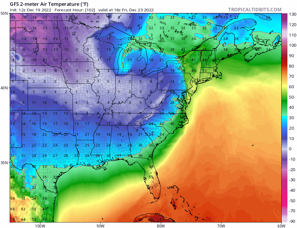
That's a wild temperature drop. I wouldn't be surprised if the starting point was a little higher (upper 50s). Warm sectors can really overperform in temps. A 40F drop looks likely for many with some seeing 45+ drops over a 12-18hr period.
-
Nam also has some pretty hefty totals (3+) just further west They also suggest single digits are very possible just outside the city.
-
960s in the lakes is not run of the mill
-
Pretty impressive cold for Xmas weekend. If we had snow cover it'd likely be in the single digits
-
Time to close the shades for a couple weeks after Christmas Hopefully it's not like 1989 otherwise game over for winter
-
GFS almost looks like it wants to pop a secondary near the coast.
-
Expectations are very low but if the PNA doesn't break down then chances for something go up.
-
And you jinxed it
-
Don't get your hopes up. I'm quietly looking at it and that's it. I fully expect failure
-
To be fair the Euro/CMC only had a couple runs with a good solution. The rest were pretty crappy.
-
There is one thing I'll be quietly monitoring. A piece of energy will be coming south after Christmas enhanced by the PNA ridge. Models aren't doing much with it now but we'll see if anything happens. Reason it's interesting is because usually there's a storm before there's a big change in the pattern. And I wonder if models are breaking down the ridge out west too quickly
-
The silver lining is at least it'll feel like Christmas. Temps for the 24-25th will be coldest we've seen in years.
-
I don't think it's gonna be that bad. Maybe it will be. I'll enjoy the mild weather if it's not gonna snow
-
The storm is slamming into a strong high to our NE so an inland secondary low is probably likely. That will really enhance the pressure gradient leading to a period of strong to severe wind gusts. Just not sure exactly where it'll form
-
Interestingly enough the CMC has some of the flash freeze elements the GFS has. It goes from upper 50s to upper 20s over a 6hr period. Flash freezes are very rare but so is this system. If you just like interesting weather then Friday could be fun.
-
Now that's an Arctic front. Less secondary this time so winds are lower.
-
That ridge near New England is no good.
-
Euro shows it too but I think they'll both back off as we get closer.