SnoSki14
-
Posts
14,682 -
Joined
-
Last visited
Content Type
Profiles
Blogs
Forums
American Weather
Media Demo
Store
Gallery
Everything posted by SnoSki14
-
If you like OP runs then Euro was a lot more promising than the GFS. It shows a PNA spike. CMC is somewhere in the middle Nice thing about the GEFS is that it restocks the cold supply over north america. That can really help if the SE ridge becomes a problem.
-
Don't you think it's a bit naive to assume any of that will play out given it's 10-14+ days out at the minimum. What we've seen thus far this winter is that the -PNA always corrected stronger and the WAR ridging trended stronger as a result. I don't suspect that will change. Ssts are off the charts too off the New England & Atlantic coast further enhancing that probability Also what are the odds we rat the rest of the way and NYC sees 0 snow for the first time in recorded history.
-
This is arguably the best model run of the season for eastern SNE within the 3-day time frame.
-
Doesn't the PNA lose relevance by February. We were able to get the Feb 2013 snowstorm despite a deep western trough
-
The weeklies looked promising Jan 25 - Feb 15 As long as the cold doesn't keep dumping west then it shouldn't be too bad
-
What is your average snowfall and how much did you receive so far?
-
Only one year was drier, the rest were wetter than normal. There's no dry trend as of now. Water temperatures are well above normal, which should continue with the mild winter and that'll favor more convection this spring/summer.
-
Well we know which ones will verify What's with the weenies... obviously I meant the snowstorms will verify. Geez tough crowd
-
I'm not taking it seriously I just think it's funny. It can't even generate a phantom snowstorm 10+ days out.
-
GFS is a toaster bath. Cutter after cutter for the rest of January
-
Desperate times
-
I have a bad feeling it'll be another crappy spring. Worst case is if we see a SSW event in late Feb or early March.
-
West ticks seem probable given strong SE Canada ridging If the trough axis wasn't so far east this probably would've been a good storm for most
-
You pretty much need that here for any condition, not just Ninas. Btw this year has behaved more like a strong Nino than a Nina. You don't typically see days of flooding rains in southern California during a Nina.
-
Anytime models hint at SE ridging it's a major concern. It just has to verify stronger than forecast, very easy to do, and welcome to cutter land. Occasionally you can get multiple cutters that force the boundary east and then eventually the last shortwave in the series can be a coastal that brings snow.
-
Another 23 days should be easy to do. Nothing on the horizon for the next 2 weeks
-
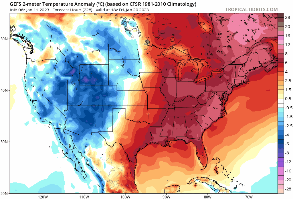
GEFS with a big step backwards. Strong WAR in place aka cutters galore. GEPS is more promising. Either way there's not much to look forward to for a long time, prob late Jan at the earliest.
-
Watch it be a repeat of December with a big wound up cutter in the Midwest and another Arctic blast. Don't underestimate the ridging east of New England. Very warm sea anomalies in that region
-
It depends if there's a light at the end. There's a flicker right now. So far there's been zero measurable snow in my area, north-central NJ or NYC. Even the worst winters had something by now. Looking at ensembles there's not much hope until the last week of Jan.
-
There's nothing on the horizon though. Pretty much nil til late Jan
-
I'll believe it when I see it. I'd be happy if we just torched the rest of the way instead of following false threats and promises.
-
GEFS has a WAR throughout the entire run. EPS looks pretty cooked as well though better than GEFS
-
Remember when things were supposed to turn around after the 10th Can kicked yet again Boy who cried wolf syndrome in full effect
-
Just go mild and 9 out of 10 times you won't lose
-
Don't they average like 150-200" though.