SnoSki14
-
Posts
14,682 -
Joined
-
Last visited
Content Type
Profiles
Blogs
Forums
American Weather
Media Demo
Store
Gallery
Everything posted by SnoSki14
-
You need arctic air though otherwise you'll get rainy coastals
-
Warm air is so close today but still hanging in the mid 40s
-
I'd rather us just torch and be completely done with this god awful winter. The blocking will just make March/April miserable.
-
Models showing the same garbage we've seen all season. No surprise there
-
All it takes is for the 50/50 to be weaker than shown and it's a bust so I'm treading carefully. The thing is in this climate we can have record warm months and still somehow get a storm or two that gives us all our seasonal snows. Not saying that's likely but it also wouldn't shock me.
-
Feb 28th-March 1st long duration Miller B threat
SnoSki14 replied to George001's topic in New England
Sometimes that's true. There was a 2010s March where everything was suppressed due to confluence. However for this one I think it's more likely to trend north over time. Gonna try hard not to jump off a cliff when it's 40F and rain down here while SNE gets a major snowstorm. -
Bias? The GFS was well north 2-3 cycles ago against the CMC & Euro. I still think this is mostly SNE storm but you're not being objective Additionally the strengthening confluence is real. Will it be enough down here? I lean no but the trend is legit.
.thumb.gif.aea0d52dfe310134f0a47c5cbf2c1714.gif)
-
It's nice to see continued improvements but it's still very borderline this far south. Given the trends this season I'm not sure it'll be enough. Looks like an excellent late winter pattern for SNE north though.
-
Feb 28th-March 1st long duration Miller B threat
SnoSki14 replied to George001's topic in New England
Time to move north -
I need to see some follow through with tonight's runs. Either they stay consistent or get better. If they get worse then I wouldn't expect much.
-
What a weenie GFS run for SNE
-
We seem to be stuck in no man's land. Probably a lot of days like today over the next month or so.
-
Any reason why the GFS solution is being discounted. Seems equally likely to verify
-
Very surprised the SNE folks are so gungho about next week. If the 50/50 is even slightly weaker or displaced then the threat falls apart. Anyone south of VT/NH/ME should be skeptical
-
How does that logic work? Suppression now equals more suppressed storm down the line?
-
For someone that's been negative all winter I'm shocked you think that's gonna verify.
-
Talk about clown maps
-
You're praying models hold the strong 50/50 a week out. That's not a hill I'd want to go all-in on
-
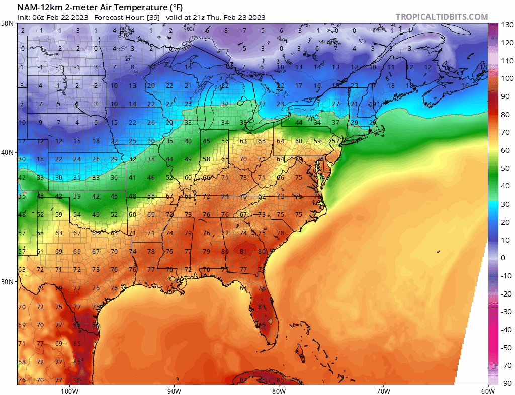
12z Nam just cut temps by 30 degrees down in NYC/NJ. From low 70s to 40s. That blows
-
12z Nam just completely shut down any possibility of warm air coming in tomorrow.
-
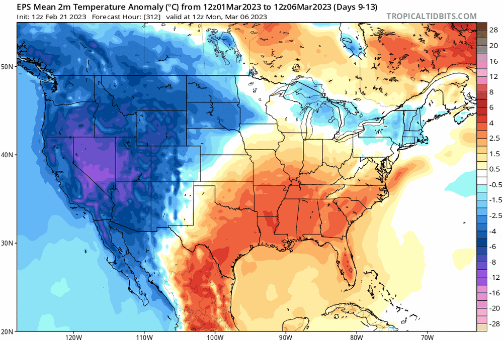
I don't think we'll be able to outdo 11/12 for the D-M period. March 2012 was extremely warm and this March doesn't look to follow that path.
-
Insanely low level snows possible in California. You know it'll be bad for us when LA can't get out of the 40s for highs in late Feb.
-
Really need that to continue otherwise we'll be near normal at best as the coldest air is west. At the very least you can probably eliminate the warm Marches like 2012 & 2020. That block will stick around for a while
-
And we're still barely BN if at all At this rate we're going to see our 2nd tornado before we see an inch of snow down in Jersey Slightly below works further north though especially C/NNE
-
Can't get an inch of snow but an effin tornado just rolled through NJ in February. WTF

.gif.014f0d4d74fedfcb50b5d78004234f96.gif)