SnoSki14
-
Posts
14,682 -
Joined
-
Last visited
Content Type
Profiles
Blogs
Forums
American Weather
Media Demo
Store
Gallery
Everything posted by SnoSki14
-
Sure but it has almost zero staying power. I personally hate late winter snows. Anything outside of a 1956 or 1888 or 2018 to some extent after March 10 is meh to me. But because I've had nothing this winter I'll settle for anything just once. Hopefully Monday night delivers
-
This one's pretty cut and dry. Stronger 50/50 equals storm (miller B transfer) while a weaker one equals cutter. The current trend is towards a weaker 50/50 Additionally given the amount of phasing likely you would need a very strong 50/50.
-
You can't ignore climo even with a favorable pattern. Our averages are climbing near 50 by then. Not many snowstorms after March 12 looking at history
-
Yes that's no good. If that continues then everyone will rain even into NNE The 3/4 is the last system I'm invested in. If that one cuts then I'm done with this winter. I don't care how favorable March 10-12+ looks with spring firmly in control.
-
You definitely want heavier rates with this given marginal temperatures. Rgem with a really nice thump. Very Euro like
-
That's during the day. Storm comes at night
-
How convenient that you suddenly praise the GFS after constantly trashing it
-
I think we'll thump for a few hours and go to sleet/light rain. But a degree will make all the difference. Wet bulb temperatures will be key
-
That's still possible because of very marginal temps.
-
Was 0.5" the record for least snowfall for the D-F timeframe?
-
It's as good as it can get imo. I'll sign up for that in a heartbeat
-
I think it's more probable the confluence will result in a miller B like solution. You can already see the 6z GFS try to attempt that. But it's too early to tell just yet
-
Still think my area in Somerset will be lucky to get an inch. Consensus has the best snows north of I-78 with general 3-6" totals and locally higher amounts. On the plus side low level cold has been overperforming as of late and this could be a rare positive bust for those slightly further south. Keep an eye on wet bulb temps and finally the fact that the storm comes at night helps too.
-
And Euro affirms that the GFS is an outlier atm. And like I said if the weaker confluence scenario is true then yes the GFS will be right but that's not a foregone conclusion. How's your Boston blizzard working out?
-
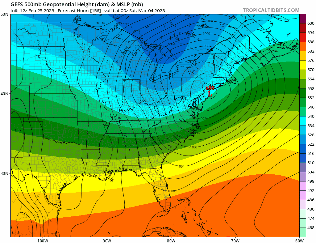
A system will rapidly deamplify and transfer to the coast under strong confluence. The setup with Greenland blocking and a 50/50 underneath suggests there will be some confluence in place. The question becomes how strong will it be. As of now the GFS solution is an outlier however if models trend towards a weaker 50/50 then a cutter will play out. In that case you'd wanna be west as even VT/NH would flip to rain. It's too early to tell exactly what will happen
-
It all comes down to the strength of the 50/50 underneath the blocking high. GFS is the weakest with it so the storm cuts N/W however the last few runs have been trending better with that feature. If trends continue then you'll see big shifts S/E and a transfer to the coast. We'll know a lot more after the 28th storm passes.
-
GFS is trending towards more confluence for the 3/4. If that continues then the storm will have to transfer to the coast like CMC shows. Unless the storm phases in that case you're looking at a powerful inland runner. Either way it should be interesting We'll know more after the 28th storm passes.
-
That's always the risk but once the Euro catches onto a trend (stronger blocking/confluence) this close-in it usually doesn't go back. And models are moving towards the Euro not against it
-
There's a good 50/50 and block in place. I think we'll see models deamplify and trend S/E like we're seeing for the 28th as we get closer. Blocking regimes are prob the only time where systems trend S/E as we get closer though that doesn't always apply.
-
Nam & Rgem can be pretty amped at this range so seeing them trend colder is a good sign.
-
Feb 28th-March 1st long duration Miller B threat
SnoSki14 replied to George001's topic in New England
Speak for yourself. Most south of 41N haven't even had an inch of snow this winter. -
Let's not count our chickens yet. We're still very much borderline
-
3/4 on GFS still cuts but clearly trending in a better direction. I'm willing to get GEFS will be east of OP
-
Feb 28th-March 1st long duration Miller B threat
SnoSki14 replied to George001's topic in New England
This could continue trending south. Euro is going in that direction with stronger confluence each run. I think W/C CT is probably in the best spot here with a lean south.