SnoSki14
Members-
Posts
16,108 -
Joined
-
Last visited
Content Type
Profiles
Blogs
Forums
American Weather
Media Demo
Store
Gallery
Everything posted by SnoSki14
-
The backend is my biggest question mark. If it's as intense as the gfs shows then it could drop several inches in 2-3 hours.
- 3,762 replies
-
- 2
-

-
- heavy snow
- heavy rain
-
(and 3 more)
Tagged with:
-
People should temper their expectations because there's significant bust potential. If the immediate NYC metro scores 6" consider that a huge win.
- 3,762 replies
-
- 3
-

-

-
- heavy snow
- heavy rain
-
(and 3 more)
Tagged with:
-
I agree the bust potential is huge. Of course what happens there doesn't necessarily mean it'll happen here. Side note I'm starting to think the backside stuff is real. Models leaning more on an intense band of snow developing as the storm slowly pulls east.
- 3,762 replies
-
- heavy snow
- heavy rain
-
(and 3 more)
Tagged with:
-
Heavier precip will be snow, lighter will be more sleety. It's going to be really close for fringe areas. Those spots are just as likely to see 6" as they are to see 12"+. Backside snows are a wildcard.
- 3,762 replies
-
- 1
-

-
- heavy snow
- heavy rain
-
(and 3 more)
Tagged with:
-
The wet bulb temps are the only thing that matters. In this case the surface temps could be 35-37 and they'd drop to 28-30F when the snow starts.
- 3,762 replies
-
- 3
-

-
- heavy snow
- heavy rain
-
(and 3 more)
Tagged with:
-
What will determine if we get those higher amounts will be any backside snows. The initial thump will be followed by a dry slot and then maybe a partial CCB.
- 3,762 replies
-
- 1
-

-
- heavy snow
- heavy rain
-
(and 3 more)
Tagged with:
-
Active mid December with multiple event potential
SnoSki14 replied to Typhoon Tip's topic in New England
I can't believe raindance said that silly statement unless he was referring to the previous system. Still the soil temp idea is pretty ridiculous when it can go from pouring to snow drifts in hours. -
Active mid December with multiple event potential
SnoSki14 replied to Typhoon Tip's topic in New England
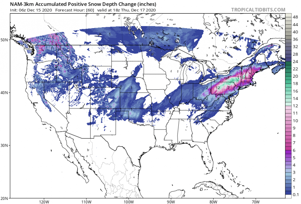
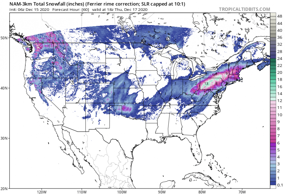
Is there a side by side of the first image comparing 06Z with 09Z. -
I'm at 8F dew so that's a good sign. Will see if the cold, dry high helps force the low more offshore as it moves north.
- 3,762 replies
-
- 2
-

-
- heavy snow
- heavy rain
-
(and 3 more)
Tagged with:
-
Yeah that's probably the best case scenario here.
- 3,762 replies
-
- heavy snow
- heavy rain
-
(and 3 more)
Tagged with:
-
It appears a quicker transfer could be the reason for the colder/snowier runs.
- 3,762 replies
-
- 1
-

-
- heavy snow
- heavy rain
-
(and 3 more)
Tagged with:
-
Still floored I'm under a WSW for 12-20" just west of Piscataway. That's a bust waiting to happen.
- 3,762 replies
-
- heavy snow
- heavy rain
-
(and 3 more)
Tagged with:
-
Nam has more confluence and is significantly better for those 20+ miles north and west of the city. Is it just the off run or will it continue, we'll see.
- 3,762 replies
-
- heavy snow
- heavy rain
-
(and 3 more)
Tagged with:
-
Are there any similarities to this with the November storm a couple years back? I remember that one taking everyone by surprise. Euro threw a life raft in a fleeting situation but could just be a fluke. If the next set of runs doesn't tick SE then you'll probably see the Euro correct NW tonight.
- 3,762 replies
-
- heavy snow
- heavy rain
-
(and 3 more)
Tagged with:
-
It was fun while it lasted but tracking for days and then it all turning to crap is crushing. At this point I'll be happy with an inch or two before the changeover. Who knows if that'll even happen given the trends. Good for PA. They've been getting skunked while we raked in the coastal for years, they deserve it.
- 3,762 replies
-
- heavy snow
- heavy rain
-
(and 3 more)
Tagged with:
-
Everything's still trending NW though that's the problem. A quick shot of snow to rain is looking more likely. Even places well north and into CT could dry slot. I wasn't trolling when I said 1-3/2-4" this morning.
- 3,762 replies
-
- 4
-

-

-
- heavy snow
- heavy rain
-
(and 3 more)
Tagged with:
-
The tucked in models would increase the coastal flooding/wind issues. Someone could gust up to 60mph, which would cause outages combined with a few inches of paste/sleet.
- 3,762 replies
-
- 1
-

-
- heavy snow
- heavy rain
-
(and 3 more)
Tagged with:
-
Yup looks like my 1-3/2-4" call looks good if that verifies.
- 3,762 replies
-
- 2
-

-
- heavy snow
- heavy rain
-
(and 3 more)
Tagged with:
-
That seems likely. The initial burst will also cool things down significantly that could prolong the snows before warming takes over. Or maybe the Gfs still scores a huge hail mary victory. Wouldn't we all love that.
- 3,762 replies
-
- heavy snow
- heavy rain
-
(and 3 more)
Tagged with:
-
Watch the dew points tomorrow morning. If they're really low (single digits) then it could mean the low will end up further offshore due to the strong press of the high north. We've seen last minute corrections east in these CAD setups.
- 3,762 replies
-
- 1
-

-
- heavy snow
- heavy rain
-
(and 3 more)
Tagged with:
-
I expect a few inches, that's not dead and I agreed with the 6" thump as long as models don't trend further inland.
- 3,762 replies
-
- heavy snow
- heavy rain
-
(and 3 more)
Tagged with:
-
Gfs is your hail mary with this storm. 12z runs will probably be the final nail in the coffin regarding track and amounts. If you want that 6" front-end dump then you better hope that don't keep trending inland.
- 3,762 replies
-
- heavy snow
- heavy rain
-
(and 3 more)
Tagged with:
-
- 3,762 replies
-
- 2
-

-
- heavy snow
- heavy rain
-
(and 3 more)
Tagged with:


