SnoSki14
-
Posts
16,212 -
Joined
-
Last visited
Content Type
Profiles
Blogs
Forums
American Weather
Media Demo
Store
Gallery
Everything posted by SnoSki14
-
Still 12F in Somerset. Rare to see most of Long Island so much colder in a CAA regime
-
??? Not in our area. Below zero weather was fairly rare even back then
-
I've heard at some point it gets so cold that it feels like you're on fire. Guessing below -100 WCs
-
Cold is much more tolerable than heat. At least you can always layer up
-
That's how we get these insane short term temperature swings Cold is nothing out of the ordinary. 15/1 right now with forecast of 8. Meh. 50+ nearly every day starting Sunday
-
Climate change denialists are having a field day on Twitter over one really cold day It could be 70F every day in January but 1 cold day is enough to bring them out
-
What does that feel like
-
More BS from the GFS We spring starting Sunday. If there's any more snow it'll happen in the Feb 25-March 15 period.
-
No it's possible it's just that it'll be a drop in the bucket compared to the record warm weather. If the orientation was different than subzero temps would've came further south.
-
GEFS is still pretty mild. A muted version of the EPS
-
Idk the EPS is looking extremely mild. I would still go +7
-
?

-
JB thought that would happen in the 2010s, instead we had the fastest warming decade on record There's nothing to suggest a cooling cycle. Net emissions are still rising, waters warming rapidly. Our baseline will increase with the next big Nino event possibly near 1.5C
-
LA & Vegas are gonna be colder than us Not even joking. We'll be pushing 60+ while they stay in the 50s or colder
-
It's coming
.gif.2ddd9fa5251b832f75dc68d3aec39e81.gif)
-
I don't think MJO is that relevant tbh. We were in the cold phases in January and it didn't matter. It's usually only relevant when there's constructive interference
-
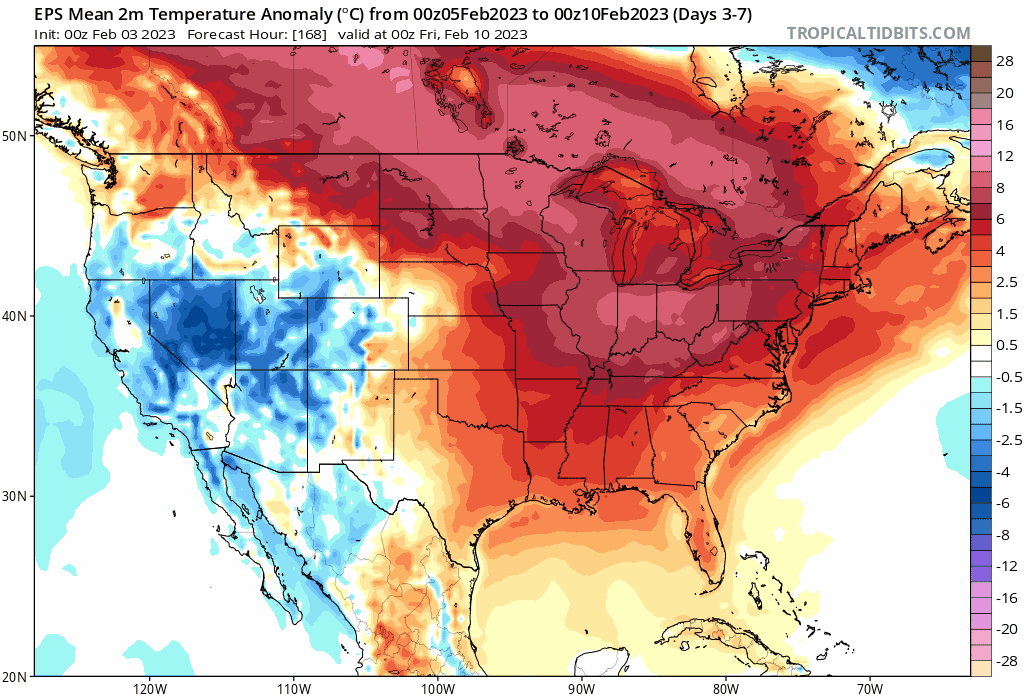
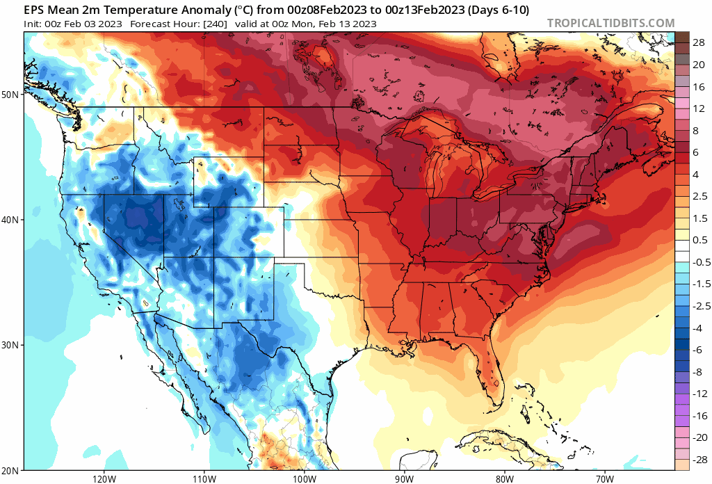
A good cutter in 2nd half of Feb could really push things near 80F again However active Pacific jet makes things very progressive so I don't think we'll see that. January managed to torch with a high baseline rather than days of 60s & 70s.
-
We haven't had a cold summer in over a decade so that ain't happening. And just because winter has been a torch doesn't mean spring will be cold. We could easily roll this torch into the spring/summer like 2012 Btw does anyone have March-May temperature departures after a warm Jan/Feb particularly years when Jan/Feb were +2 or greater over the last 10-15 years
-
There's a chance at something around the 10-11th before it goes super torch
-
Perfect alignment of unfavorable MJO and Nina forcing Despite that models point to sneaky cold/snow around the 10-11th. Afterwards we pretty much roast until late Feb.
-
March could easily average colder than this Jan/Feb if it's just slightly BN
-
Almost 60 and mostly 50s in 1st half of February. Basically late March to early April weather. Not even touching freezing at night. Never seen anything like it.
-
It would be incredible if Jan/Feb 2023 were the warmest months on record
-
Same here. That and their inauthentic, overly cheery delivery
-
It's pretty close