

SnoSki14
-
Posts
16,212 -
Joined
-
Last visited
Content Type
Profiles
Blogs
Forums
American Weather
Media Demo
Store
Gallery
Everything posted by SnoSki14
-
What does a Nina phase 5-6 look like in March?
-
I've been watching this for a while. Some significant ecological damage with the growing season this far along in mid Feb. With the warmth ramping up this will only worsen
-
And you know what you're talking about? Pulling up random Twitter threads that justify your narrative doesn't make you an expert.
-
That's a favorable look for late winter if true. Lots of cold available. The RNA/-PNA isn't a detriment like it can be in early-mid winter. At the very least you could get some SWFEs. Models are definitely trending towards a -NAO
-
Saying every winter will be a snowless torch is equivalent to JB saying it'll be cold & snowy every season. Dead clock
-
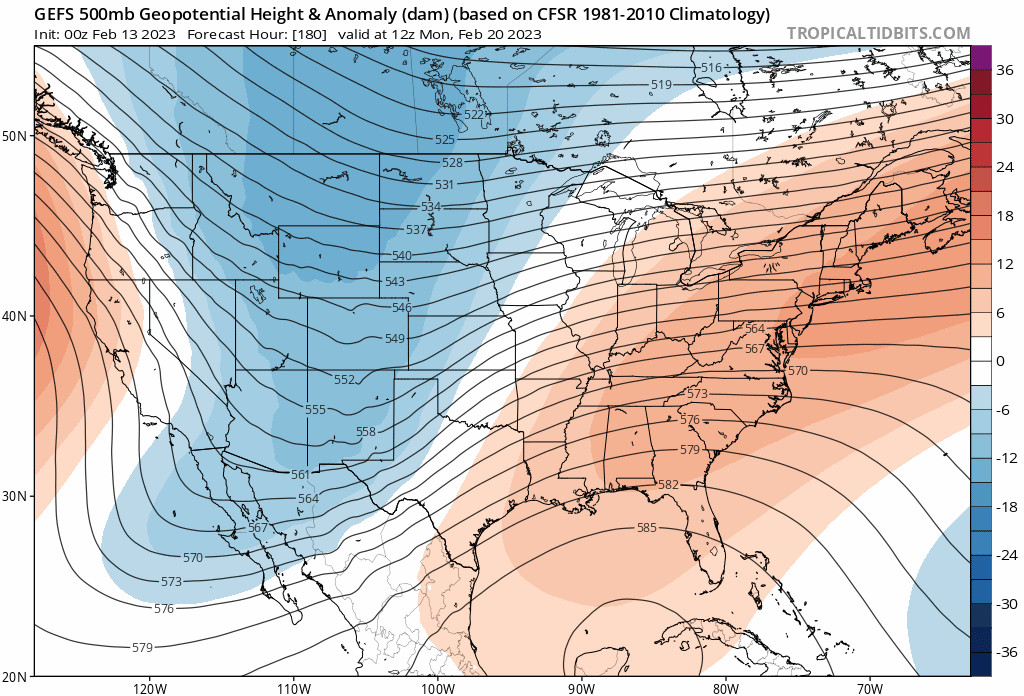
First time -NAO showing up on GEFS Clown range for now but models have also shown hints of the TPV pressing south in the mid range. PNA becomes less of a factor after mid Feb.
-
Nice to see the TPV pressing south on the GEFS

-
Boston is getting 100" minimum Calling it now
-
Next winter is gonna be the complete opposite of this year. It's gonna be wild. Climate change favors extreme swings
-
Some arctic blocking would really pin this sucker down. Pacific ain't changing but it doesn't have to in this setup.
-
The effects of a -PNA in March is different than a -PNA in mid winter. Just need some arctic blocking
-
We definitely should for DJF or met winter. March is still a question mark. Next 2 weeks are a blowtorch though with multiple 60+ days
-
Warm weather is nice for a few days in the winter but not for weeks at a time With the coming warmth this week we're going to be seeing leafouts a month ahead of schedule. Allergy season will be heightened and the bugs will be worse than ever.
-
I agree it's not healthy. It's going to throw everything out of whack A day or two of 60+ is fine but we've already had a record warm Jan. GFS gives us multiple rounds of 60+ and even 70+ temperatures in mid Feb.
-
I think it'll be #1 in most places given the warmth rest of Feb. Futility will beat out 01/02 as well When all is said and done D-F will rank as the least snowy & warmest winter on record.
-
Subtle hints from the GEFS for blocking. I think that signal will strengthen in the coming days and weeks
-
It depends if March continues the mild theme. If it does then its gonna be an early & brutal allergy season
-
Turning colder is easy when you have 60s in mid Feb. Hell 45-50 would be a big step down but it doesn't mean anything. You'd need a full scale pattern change aka blocking to deliver real cold & snow in March and I don't know if that will happen.
-
You know its bad when you have to go into interior ME on Feb 10 to find good snows.
-
Looking at the 10 day forecast and I can't believe it's mid Feb. It reads more like early April. Record early green ups coming. Next week will be warmer than this one
-
Not exactly sure what the criteria is. Isn't 50F the minimum level for germination. They also differentiate between leaf index and bloom which happens much later.
-
Things are moving north fast. 3 weeks ahead of schedule already Today and tomorrow will really accelerate that process
.thumb.png.13ccf9fcddac26c15a8b9fa252134fd6.png)
-
Maybe. If there's any month that could have blocking, it's March and early season blocking (December) does tend to repeat eventually. But you're also fighting climo by then. You need a cold March to get snow.
-
Very reasonable forecast. Down here we might get our first inch in March this year. Only the second time in my lifetime if that happens But it's only Feb 9 so take the weeklies with a grain of salt. Very low bar to clear for March to outperform Jan/Feb though.
-
Can you imagine that right now. It's been so warm and snowless that I can't even consider that happening.


.png.e7987971853678b1fa69b4846e808b6a.png)

