SnoSki14
Members-
Posts
16,108 -
Joined
-
Last visited
Content Type
Profiles
Blogs
Forums
American Weather
Media Demo
Store
Gallery
Everything posted by SnoSki14
-
Things can only get better from here but not until next season
-
Beating #1 is looking good right now
-
Not that high. Pacific jet is too fast. Not seeing wound up cutters slowly moving east
-
Or does it even matter. We've spent plenty of time in favorable phases with very little to show for it. MJO & SSWE are overrated imo as is the NAO & Siberian snow index. It's almost a fraud five of sorts.
-
Yeah this is one for the record books. We will challenge the futility record for lack of snow + warmth (already #3). I don't need a pity March snow either that melts the next day or a miserable March (30 & 40s with rain) either.
-
Important to note that a SSW event doesn't guarantee cold/snow even if it were to occur
-
Are you a sadist? Let it go.
-
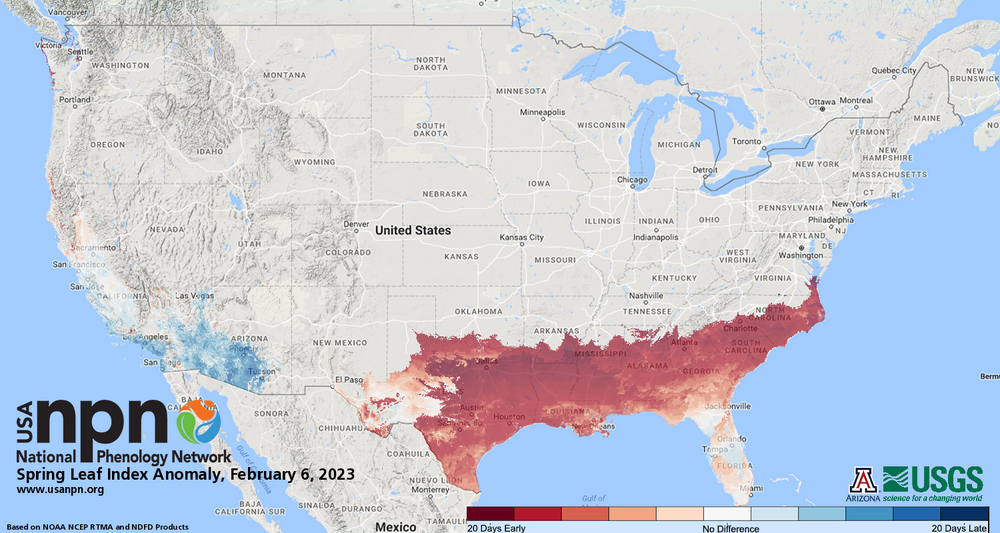
We are going to see record early blooms this season and the ecological impacts could be very damaging due to the record warm Jan/Feb combo. We're already seeing leafouts 3+ weeks ahead of schedule in the SE. My forecast is mainly 50s & 60s with even warmer days mid Feb possible.
-
-
With near 60 in the forecast and days getting longer I anticipate a lot more budding
-
The oceans could evaporate and it could be 130+ everyday and they'll still deny it. There's no such thing as reality for these people
-
For that to verify the last 10 days of this period would have to be extremely cold
-
What a torch on the models. 60+ now showing up easily. Warm & wet
-
Now that's what I call global warming
-
I hope we set the futility record. All this garbage should have something to show for it. I don't need a pity March advisory event that's gone the next day.
-
We should move up the chart by mid Feb. Very mild with no snow next 2 weeks.
-
Looks pretty crappy this week honestly. Lots of clouds followed by wet weather late week into the weekend. It's been a warm, snow-free winter but not a dry, sunny one courtesy of an active Pacific
-
I have higher confidence in a late season event. There's support for a favorable late winter period.
-
Yeah that's usually a good sign but I wouldn't bet on a favorable outcome south of NNE. It does appear that there could be one more favorable period between Feb 20 and March 15. CFS weeklies show it. MJO trying to move into more favorable phases by then as well. The seasonal transition periods are always interesting too, can really shake up a stale pattern
-
Yup. Boston is pushing 50 by tomorrow which is crazy given this mornings reading
-
To be fair they've been mostly right with the warmth this year. One or two really cold days can't take away from how warm its been.
-
Still 12F in Somerset. Rare to see most of Long Island so much colder in a CAA regime
-
??? Not in our area. Below zero weather was fairly rare even back then
-
I've heard at some point it gets so cold that it feels like you're on fire. Guessing below -100 WCs
-
Cold is much more tolerable than heat. At least you can always layer up


