

SnoSki14
-
Posts
16,212 -
Joined
-
Last visited
Content Type
Profiles
Blogs
Forums
American Weather
Media Demo
Store
Gallery
Everything posted by SnoSki14
-
This winter is still a massive turd and remains the worst by a good margin but I agree that it's unlikely we set a new record for low snow totals.
-
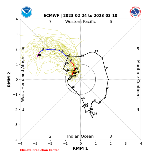
Also note the highly amplified MJO into phase 8 near March 8-10. Phase 8 in March isnt as cold as in other months but it still carries weight
-
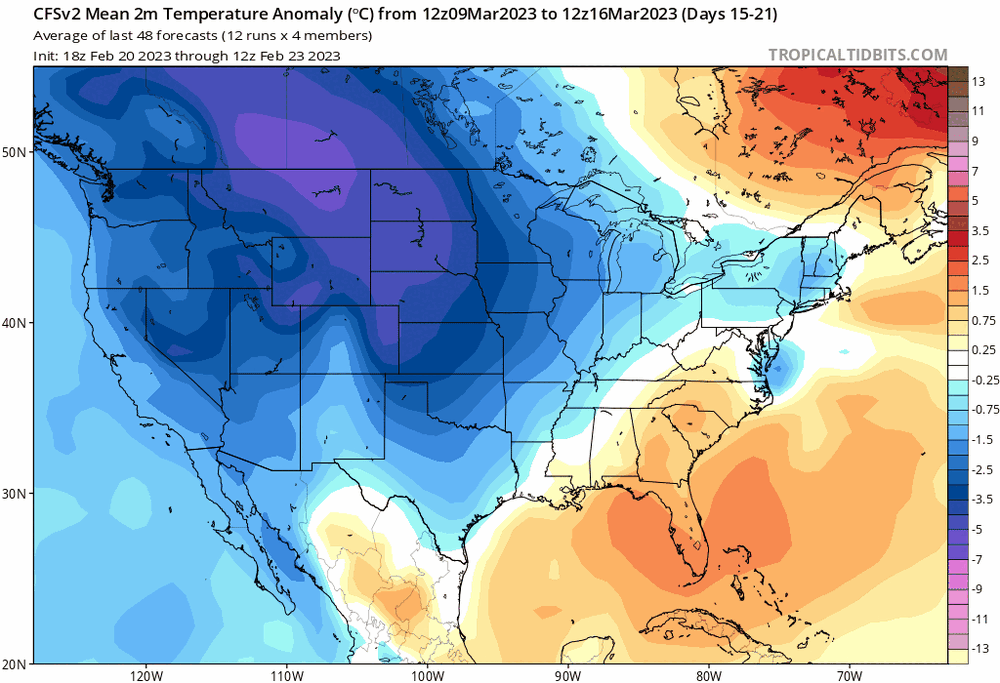
This is how I see the next month playing out Some snow showers and maybe light accumulations on the 25th aka tomorrow. Storm potential March 3/4 followed by brief warmup (could be very warm for 1-2 days) and then an extended cool period starting near the 10th as heights build in the arctic and strong RNA pattern breaks down. That could last til the end of March and into April. Beyond March 3/4 there's probably another snow window or two in the March 10-25 time frame. After that climo is very much against us even if anomalies stay cold.
-
Feb 28th-March 1st long duration Miller B threat
SnoSki14 replied to George001's topic in New England
Euro shows a suppressed storm atm which is fine this far out. No need to worry about the March storm yet until this one plays out though. -
Same here. We've had less than 0.5 for the year
-
Feb 28th-March 1st long duration Miller B threat
SnoSki14 replied to George001's topic in New England
That looks more impressive/significant to me than the 28th threat. Mod/high risk of the 28th continuing to deamplify leading to lesser amounts. I've yet to see 6+ cycles of the GFS showing a storm over a week out this season like the early March event -
If it wasn't this winter I would be excited for that potential. That being said that's a strong signal this far out with a lot of favorable elements in place. GFS has been showing the threat for 6+ cycles. That's unheard of for over a week out.
-
A dusting would be my biggest event this season
-
Not looking too promising there. Euro weeklies get chilly 2nd week onward too.
-
Don't worry you'll get 8 months of it.
-
Temps underperforming today meanwhile it's 80 in DC.
-
CMC cuts it too so I believe it. If there's a last hurrah it'll be in the March 5-20 period unless models trend favorably for the 28th. Ensembles show heights rising across the entire arctic & Alaska after March 5. West trough is still there but by then it has a lot less relevance.
-
No worries a big cutter washes it all away a few days later.
-
You need arctic air though otherwise you'll get rainy coastals
-
Warm air is so close today but still hanging in the mid 40s
-
I'd rather us just torch and be completely done with this god awful winter. The blocking will just make March/April miserable.
-
Models showing the same garbage we've seen all season. No surprise there
-
All it takes is for the 50/50 to be weaker than shown and it's a bust so I'm treading carefully. The thing is in this climate we can have record warm months and still somehow get a storm or two that gives us all our seasonal snows. Not saying that's likely but it also wouldn't shock me.
-
Feb 28th-March 1st long duration Miller B threat
SnoSki14 replied to George001's topic in New England
Sometimes that's true. There was a 2010s March where everything was suppressed due to confluence. However for this one I think it's more likely to trend north over time. Gonna try hard not to jump off a cliff when it's 40F and rain down here while SNE gets a major snowstorm. -
Bias? The GFS was well north 2-3 cycles ago against the CMC & Euro. I still think this is mostly SNE storm but you're not being objective Additionally the strengthening confluence is real. Will it be enough down here? I lean no but the trend is legit.
.thumb.gif.aea0d52dfe310134f0a47c5cbf2c1714.gif)
-
It's nice to see continued improvements but it's still very borderline this far south. Given the trends this season I'm not sure it'll be enough. Looks like an excellent late winter pattern for SNE north though.
-
Feb 28th-March 1st long duration Miller B threat
SnoSki14 replied to George001's topic in New England
Time to move north -
I need to see some follow through with tonight's runs. Either they stay consistent or get better. If they get worse then I wouldn't expect much.
-
What a weenie GFS run for SNE
-
We seem to be stuck in no man's land. Probably a lot of days like today over the next month or so.

.gif.014f0d4d74fedfcb50b5d78004234f96.gif)
