SnoSki14
-
Posts
14,682 -
Joined
-
Last visited
Content Type
Profiles
Blogs
Forums
American Weather
Media Demo
Store
Gallery
Everything posted by SnoSki14
-
It's certainly a lot colder than I expected. Ensembles really want to keep the PNA which automatically increases our snow chances. MJO forecasts also backing out of going into phase 4
-
Gfs all alone on the Arctic press which means it's most likely wrong. We generally want the Arctic high to be in place ahead of the system not as it's approaching. CMC likely to be correct imo. NNE will do well
-
I'm not buying the GFS until other models do and personally think it'll cave by tonight and definitely by tomorrow. We'll most likely see a cold rain (35-40F) and could finish with some snow showers before the storm ends With Ukie trending warmer, CMC warm this will end up as a non-event. The Arctic high generally needs to be in place ahead of the system for us to get frozen precip.
-
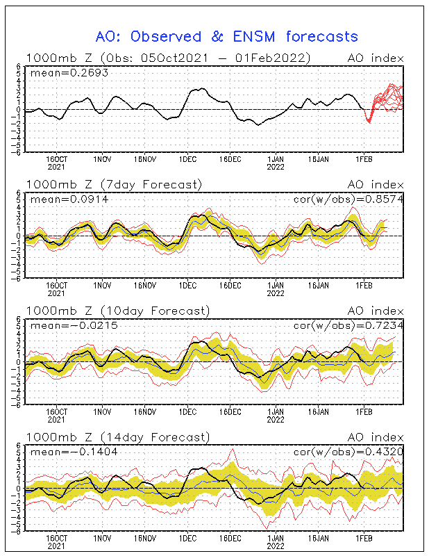
That AO dip is interesting. It does support some sort of coastal storm.
-
GFS ticking warmer though anyone above the Trenton line would still face a significant icing situation.
-
If the Arctic press is real then it'll keep trending colder.
-
It puts areas N/W on notice. I guess we'll see where the trends are today.
-
The GFS is likely too much of an outlier so it should trend warmer today. If it doesn't then it would be another major fail from the other models.
-
Models trending towards GFS is concerning regarding icing potential. Hopefully that reverses tomorrow
-
Very odd that GFS didn't back down at all.
-
After March 15 I'm done with winter so hopefully the sswe is a false flag.
-
That's fair until the other models trend towards GFS.
-
It was warmer initially but then it got colder particularly 850s with the 2nd low so we get a few inches. The other models need to come south though otherwise the GFS is an outlier and lost.
-
That's a very meh pattern that should break AN. No torch though. It'll probably serve New England and the Midwest well.
-
It builds in too late. That's where the differences lie. If the high builds in ahead of it then it'll play out more like the GFS. Otherwise it'll be more like a cold front or anafront
-
I wouldn't jump to any conclusions yet. The worst case scenarios for the past storm never played out. If models trend stronger on the shortwave then GGEM will be correct
-
Perhaps a compromise between the two models then.
-
Yeah and it also had a massive storm west of the BM. GFS performed a lot better. We'll see if the Euro follows though.
-
Oh great central & SNE get a big storm and we get the ice. I'll take the all rain option down here but CMC didn't do so hot with the last system.
-
The GFS run gives you everything. Rain to ZR to sleet to snow. It didn't back down from 06z, it actually trended even colder.
-
I know Icon is usually terrible but yikes at the ice threat it shows. Nam also trending south.
-
That depends if the Arctic high builds to our north fast enough. On the warmer models it builds in as the wave approaches.
-
06z GFS could be a fluke run. It's considerably more suppressed than 0z. We'll have to see if 12z confirms the trend. There's some dangerous amount of ice being shown just N/W of city with surface temps falling through 20s.
-
Worth watching given strong Arctic high to the north. Cold air always wins in those scenarios.
-
Reminds me of ice setups the southern plains get with the Arctic high supplying cold air that rapidly turns a cold rain into ice. Hopefully it's wrong