SnoSki14
-
Posts
16,212 -
Joined
-
Last visited
Content Type
Profiles
Blogs
Forums
American Weather
Media Demo
Store
Gallery
Everything posted by SnoSki14
-
Has a norlun look to it by Saturday morning. That could lead to locally much higher amounts Nam shows this now
-
I didn't even know that much of a pack could exist. Always figured it would compact down to much less.
-
There might be a shot of arctic air with a storm nearby at the tail end of the March 13-20 period. That's probably our last chance at anything if the next 2 waves don't work out
-
The 06z Euro has over an inch of QPF and the system mostly falls overnight. A slightly colder air mass and we would've had a solid 6-10 or better storm.
-
Wave 1 would've been a really nice storm if the air mass was slightly colder Same air mass a month earlier probably would've worked too
-
The last hurrah? Putting all the eggs in the Tuesday 3/14 basket
SnoSki14 replied to Ginx snewx's topic in New England
So much for blocking can't screw you over twice this season -
The last hurrah? Putting all the eggs in the Tuesday 3/14 basket
SnoSki14 replied to Ginx snewx's topic in New England
Are there any Euro snow maps? -
The last hurrah? Putting all the eggs in the Tuesday 3/14 basket
SnoSki14 replied to Ginx snewx's topic in New England
GFS was going for an Icon solution it just did it later. I bet the Euro will show something similar. -
March 10-11 light snow threat for SW New England.
SnoSki14 replied to Sey-Mour Snow's topic in New England
Yeah it's white rain for the coastal plain. -
The last hurrah? Putting all the eggs in the Tuesday 3/14 basket
SnoSki14 replied to Ginx snewx's topic in New England
A flop is much more likely than a historic storm especially this late in the season. A rats gonna rat. I'm really gonna appreciate even an average winter if it ever comes -
Nice trend in the GEFS for early next week
-
The last hurrah? Putting all the eggs in the Tuesday 3/14 basket
SnoSki14 replied to Ginx snewx's topic in New England
GFS being suppressed right now is probably a good thing. In the past that was a big coastal signal. Big move towards the Euro too -
The last hurrah? Putting all the eggs in the Tuesday 3/14 basket
SnoSki14 replied to Ginx snewx's topic in New England
A few days ago ensembles had coastals as low as 940-950mb. Maybe we'll see a warmer 1888 redux -
The last hurrah? Putting all the eggs in the Tuesday 3/14 basket
SnoSki14 replied to Ginx snewx's topic in New England
Have to admit this is a nice look.
-
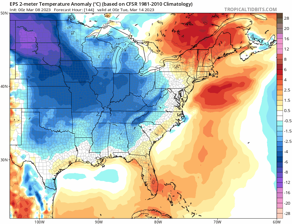
The trends are good though. Would be nice if they continued. You're getting northern stream involvement and more cold air is being drawn in.

-
You gotta dump that primary over upstate NY first.
-
Still think this one has a better chance at delivering snow than wave 2 with more cold air available.
-
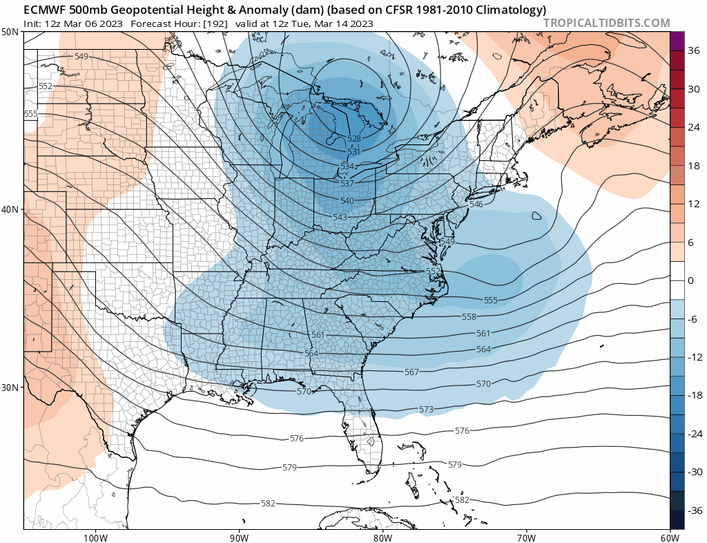
There's a lack of an arctic high. You can see the semblance of a primary over upstate NY You're going to get white rain or just rain on the coastal plain even with a great track.
-
The last hurrah? Putting all the eggs in the Tuesday 3/14 basket
SnoSki14 replied to Ginx snewx's topic in New England
Sucks the air mass isn't a little colder for us down here. That track ain't bad -
The last hurrah? Putting all the eggs in the Tuesday 3/14 basket
SnoSki14 replied to Ginx snewx's topic in New England
Probably the opposite however it could be an inland runner. Likely another congrats NNE storm -
The GFS not being so wrapped up isn't a bad thing right now
-
Deep interior is favored for both waves. At this time I don't see the coastal plain getting much if anything You either need arctic air in March or a deep coastal low to get significant snows. We're banking on the 2nd option
-
The last hurrah? Putting all the eggs in the Tuesday 3/14 basket
SnoSki14 replied to Ginx snewx's topic in New England
The one for early next week -
The last hurrah? Putting all the eggs in the Tuesday 3/14 basket
SnoSki14 replied to Ginx snewx's topic in New England
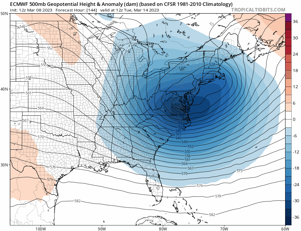
I mean this doesn't look reassuring.
-
I'm not getting my hopes up. There's at chance at something significant but everything has to go right for that to happen. Cold looks marginal. You need a powerful coastal system to get snow to the coast.