LakeEffectOH
-
Posts
331 -
Joined
-
Last visited
Content Type
Profiles
Blogs
Forums
American Weather
Media Demo
Store
Gallery
Everything posted by LakeEffectOH
-
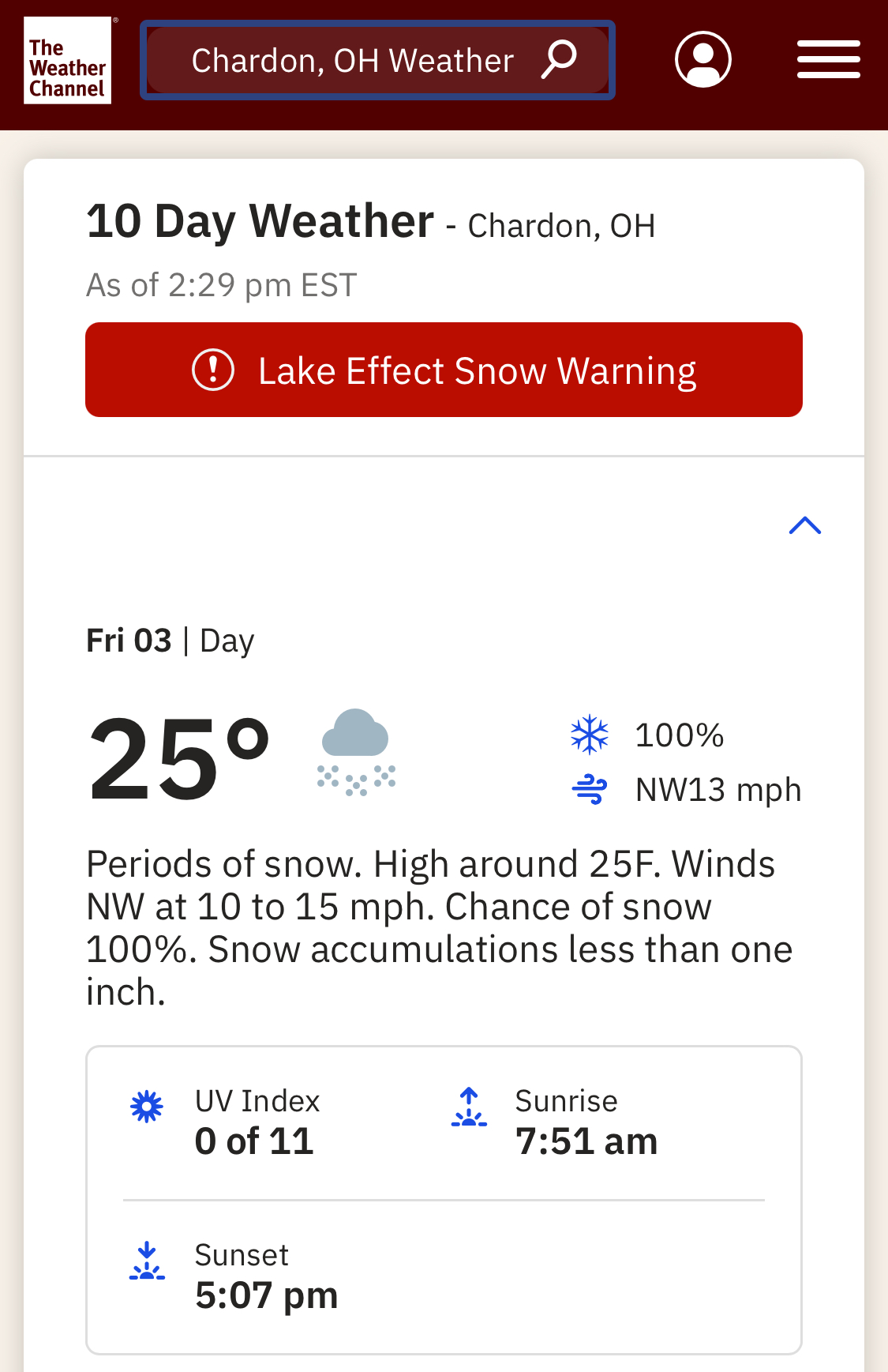
I got around an inch here.
-
Looks as the mean gets stuck in the COD. IMHO, that means a muted effect.
-
Awww, don't say that...remember April 2007?
-
Had about 8" of fluff yesterday. We must have been caught under that same persistent N-S band coming off L. Huron.
-
Tell me about it...back in early December, Saybrook, OH had over 5 feet of snow via lake effect. I live about 15 miles from there and there was not even a dusting. Several days later, I finally had about 6 inches.
-
Yeah, from the looks of the water, I'd imagine that area will be frozen over in a matter of days.
-
When I left for work this morning, there was freezing drizzle and snow pellets falling. Snowing nicely here at work in Solon.
-
Nice! NWS is forecasting off & on LES this week (2 events to be more accurate), though amounts will be light. NWS keeps going back and forth with 1-2"/event to less than one inch between point forecasts. I just hate the term less than one inch or one half inch. Ugh!
-
Hopefully we can see more LES this coming week. As more ice forms on the lake, the chances of particularly heavy snows will decrease. While it’s certainly been cold, it hasn’t been that cold, plus we had a mini torch between Christmas and New Year’s. Hopefully these two factors will buy us a little more time. I have had about 11” since it started snowing on New Year’s night.
-

-
And tonight-tomorrow as well
-
4-5” is about what we’ve picked up here in Chesterland so far today. Wind is picking up too!
-
Yes! Thanks! Snowing like crazy out now. Just had a bout of pessimism, especially after being missed by the severe LES of early December
-
Heavy snow here! I guess my inner reminded me of how I missed epic LES snowfall by 10 so miles, not to mention several big ticket LES vents over the last few years.
-
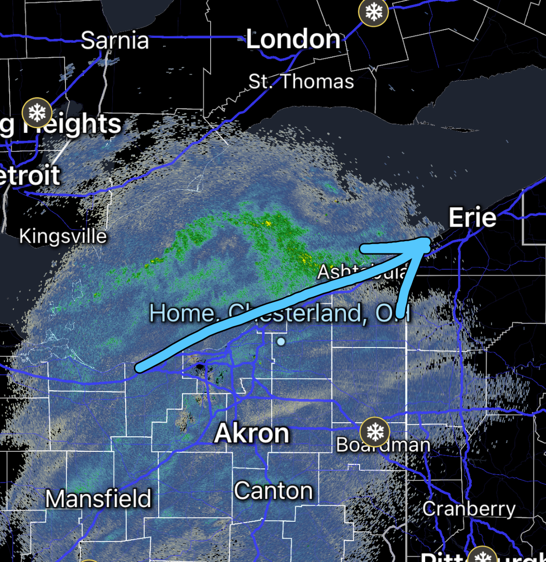
Well, is our LES storm going to deliver or will it be another Ashtabula/Erie special? Bands appear to be parallel to the lakeshore.

-
With the extended cold coming up, a good, hopefully deep, snowpack will develop over the next couple of weeks.
-
Hopefully we’ll get more LES this next time around than we did earlier this month due to the lakeshore hugging nature of the snow bands.
-

Winter 2024-25 Medium/Long Range Discussion
LakeEffectOH replied to michsnowfreak's topic in Lakes/Ohio Valley
Reminds me of JB. -
Winter 2024-25 Medium/Long Range Discussion
LakeEffectOH replied to michsnowfreak's topic in Lakes/Ohio Valley
Don't look now, but I saw the BAM Wx long range video today. Walt really backed off on the early - mid January cold. He said the polar vortex, in the models appears to be moving to the other side of the globe. -
Had about 2" in Chesterland, but when I arrived at work, in Solon, I saw at least 6" on the picnic tables!
-
Don’t have a good feeling about places south of Rt 6…growing bust potential. I think the heaviest snow will stay to the north in Lake County with 1-3 inch totals south of Rt 6. Hopefully I’m wrong.
-
What do you think the snow potential is for Northern Geauga county is for Sunday night and Monday?
-
Is anyone here on the Bluesky App? I am. http://@dohubb.bsky.social
-
Does anyone have some idea as to what's causing this marine heatwave?
-
This outlook doesn't surprise me with the PDO setup we currently have. This PDO setup will probably persist into the winter months.