

Lightning
-
Posts
1,165 -
Joined
Content Type
Profiles
Blogs
Forums
American Weather
Media Demo
Store
Gallery
Everything posted by Lightning
-

2023 Short/Medium Range Severe Weather Discussion
Lightning replied to Chicago Storm's topic in Lakes/Ohio Valley
Love this weather!! Feels great to me. Yep as expected the sun is pushing into southern MI mostly SW MI and extreme SE MI. As SPC points out: Visible satellite imagery has shown significant erosion of the stratus across southwest Lower MI as the differential heating zone becomes an effective warm front amid strong southwesterly surface winds. Dewpoints are now in the upper 70s with temperatures in the upper 80s/low 90s across southwest Lower MI. Temperatures are still in the upper 70s/low 80s farther north and east, with lower dewpoints there as well. Even with the more moist and warmer conditions, some convective inhibition currently still remains across southwest Lower MI, evidenced by the billow clouds on visible imagery. Additional heating, coupled with low-level moisture convergence over the region, may be able to overcome this convective inhibition, promoting warm-sector thunderstorm development. There is some uncertainty regarding this scenario, but any warm-sector storms that do form would likely be supercellular and capable of all severe hazards, including tornadoes. -
2023 Short/Medium Range Severe Weather Discussion
Lightning replied to Chicago Storm's topic in Lakes/Ohio Valley
Firing east of Ludington now -
2023 Short/Medium Range Severe Weather Discussion
Lightning replied to Chicago Storm's topic in Lakes/Ohio Valley
Looking back this particular run by the HRRR was pretty darn close (of course not perfect) to what happened -
2023 Short/Medium Range Severe Weather Discussion
Lightning replied to Chicago Storm's topic in Lakes/Ohio Valley
One concern I have is the cloud cover is not burning off very fast at all. Most of southern MI is still cloudy and it is 3PM. I was hoping the sun would be out a bit more by now across southern MI. -
2023 Short/Medium Range Severe Weather Discussion
Lightning replied to Chicago Storm's topic in Lakes/Ohio Valley
SPC upgrade the tornado to 5% for this area: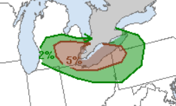
-
2023 Short/Medium Range Severe Weather Discussion
Lightning replied to Chicago Storm's topic in Lakes/Ohio Valley
If you get a chance watch the satellite loop. Interesting/fun to see the holes opening up so rapidly.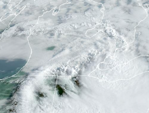
-
Got an 1". Area just (couple miles) to my south got 2-6" with some flooding but I didn't see any significant on my way to work (just some large yard puddles and ditch flooding).
-
2023 Short/Medium Range Severe Weather Discussion
Lightning replied to Chicago Storm's topic in Lakes/Ohio Valley
Last night was definitely modeled better than the previous night. I think it has to do with the storms were already ongoing last night while the night before the most of the models were too quick to develop convection making an MCS in MI that just didn't occur. -
2023 Short/Medium Range Severe Weather Discussion
Lightning replied to Chicago Storm's topic in Lakes/Ohio Valley
I really like the set up going into this week. This is the perfect set up for prolific rain totals. Little bummed MBY somehow only got 1" while most surrounding areas got 2-6" as DTX warning mentions. A 10" rain event would be incredible. As it is 6" is a ton of rain!! It is going to be interesting to see how the rest of today goes as right now the radar is still firing some stuff up. -
Looks like you in Columbus got more than I did out it. Ended up with 1.04" according to my rain gauge. Heaviest rains were just to my south by just a few miles. Hartland (I am just north of Hartland), Brighton to Milford area likely got 3-5". Lightning was nonstop strobe light for good 3 hours. Had about 4 good strikes around MBY with the initial couple cells that went though. The CG shifted south with the heavier rains unfortunately. It was nice to at least get something.
-
Have fun. Not sure if anything is going to happen here . I going to get some sleep since nothing is firing to my NW.
-
Near continuous flash coming from that cell now to my east. Charlie Brown doesn't hold a candle stick to me with bad luck
-
The cell developed just to my east. Saw one flash from it. Hopefully it will continue to develop north and west.
-
Keeps showing it triggering in Wisconsin. This is where I am struggling to buy into it. We'll see in the next few hours what actually triggers.
-
Been watching the clouds starting to form right overhead as they are feeding into that complex. To my west was mostly clear and to my east mostly cloudy the past few hours.
-
2023 Short/Medium Range Severe Weather Discussion
Lightning replied to Chicago Storm's topic in Lakes/Ohio Valley
Interesting. Can't say I trust it. But might be driving to the best instability??? -
2023 Short/Medium Range Severe Weather Discussion
Lightning replied to Chicago Storm's topic in Lakes/Ohio Valley
Drinking the NAM 3km cool-aid -
2023 Short/Medium Range Severe Weather Discussion
Lightning replied to Chicago Storm's topic in Lakes/Ohio Valley
They were originally expecting more storms over SE MI than what occurred. Most of SC/SE MI would have remained much cooler if the storms/clouds over Lake Erie/Huron were further west like was forecasted/modeled (by most models). The models that were furthest east were correct and these areas have remained mostly sunny and the push of warmth made if further east. -
2023 Short/Medium Range Severe Weather Discussion
Lightning replied to Chicago Storm's topic in Lakes/Ohio Valley
Wow 2.75 at Selfridge: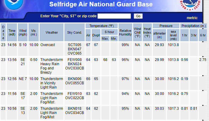
-
2023 Short/Medium Range Severe Weather Discussion
Lightning replied to Chicago Storm's topic in Lakes/Ohio Valley
Couple times I was up there with graupel around Sept 28th. I don't think that will be the pattern this year but you never know in the UP -
2023 Short/Medium Range Severe Weather Discussion
Lightning replied to Chicago Storm's topic in Lakes/Ohio Valley
Hey I nailed it => "find a way to get to Detroit (Wayne county)" Storms missed MBY by about 20 miles (or less actually). Oh well. Hopefully something fun happens the next couple days. Lots of potential at least. -
I got missed today by 20 miles to my east Good luck and enjoy!!
-
2023 Short/Medium Range Severe Weather Discussion
Lightning replied to Chicago Storm's topic in Lakes/Ohio Valley
Looking too far east for MBY but I am sure it will find a way to get to Detroit (Wayne county). It just get tiring that something always seems to go wrong when the models are blasting this area. Been in the UP a total of 12 days this summer and have had far better T-storms up there!!! Time to be Bo's neighbor!! -
2023 Short/Medium Range Severe Weather Discussion
Lightning replied to Chicago Storm's topic in Lakes/Ohio Valley
Except no MCS developed as modeled. Pure Michigan!! Only took until 6AM for some storms to even develop in northern lower -
Light rain (currently <0.1") here and temp at 66 @ 2PM. Sounds like you got some good rains today!! Hoping for something fun here in the next couple days.

