Lightning
-
Posts
1,165 -
Joined
Content Type
Profiles
Blogs
Forums
American Weather
Media Demo
Store
Gallery
Everything posted by Lightning
-
Awesome pics. I love to get events like this!!
-
Yep with these big systems (that track well to the NW) the t-storms split at LM going north and south into ILL,IN and OH. It is nothing new. I have learned to ignore the models that think MI is a target in April and May with these big systems. I know some models still want to re-ignite in MI tonight I would not bet on it but we will see. FYI ... This is meant to be an observation and not a complaint. I have had some decent storms so far just commenting about the 2 large storm systems that have gone NW into ND / northern MN.
-
Exactly CGs (hence my profile pic). I see yours has updated appropriately too I also love the heavy rainfalls as I don't have flooding concerns really (it would need to be a Noah level event).
-
While I love t-storms, I really don't really mind missing the very destructive & tornadic ones. Not surprised by the results at all. This system was too far west for southern MI.
-
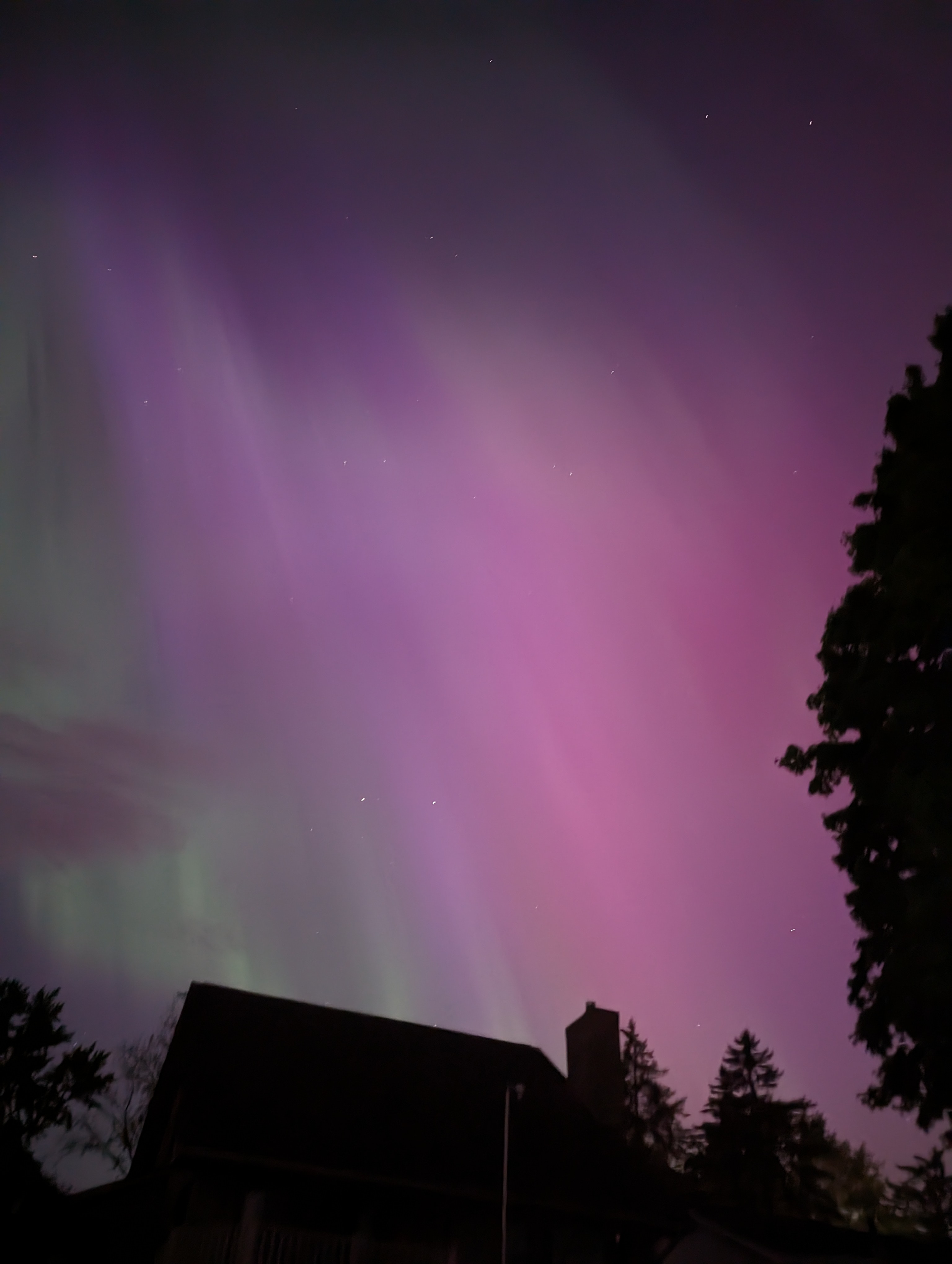
The Aurora have made up for my weather boredom. I am ready for Tstorm season to begin. I didn't chase them as it was looking good for them to come my way but sadly I was mistaken. Oh well plenty of storms to come in life.
-
Yeah this system was very disappointing. Hopefully storms will shift our way in the coming weeks.
-
There were times it looked liked the Aurora were pouring out of the big dipper. It was so cool.
-
I had that happen a couple times when I went to MTU. My pictures didn't do it justice. I have seen several and I would say this was the second best show I have ever seen.
-

-
-
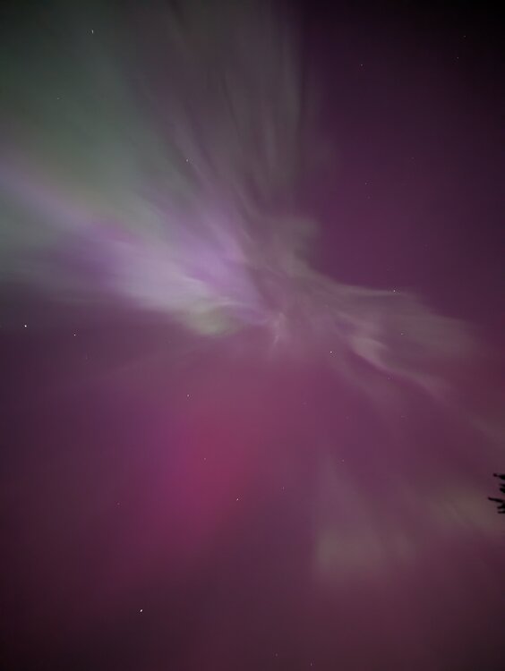
Just awesome. Sorry not the best photos.

-
It is incredible right now. The Aurora Borealis are amazing. Post pics later.
-
Ended up with garden variety storms with 0.6" of rain. Watching radar you could definitely see the stronger convection struggling to get north of 96 by Howell.
-
Nothing really overnight and typical remnants IMBY this morning. Got 1/3" total. At least it is wet. Might get something this afternoon; we'll see. Overall pattern seems active but not seeing much exciting for my area yet but tis the season of leftovers
-
Oh sorry, I was referring the band that lifted north overnight as some models had strong storm well into my area in the morning hours of today (which only turned out to be some okay rain without any thunder). The stuff in Ludington yesterday was never projected to come close to my area so I honestly wasn't really paying any attention to it. Ludington to Manistee is one area that does well very consistently with t-storms as does Benton Harbor to Coldwater area. Yeah I am also hoping May is much better t-storm wise. We shall see.
-
I am not surprised by the results. Heavier stuff remained to our south with these setups. Pretty typical this time of year as the colder Great Lakes seem to keep things in IN and OH; storms just get into the southern 2 rows of MI (Coldwater, Kzoo and Jackson). Tomorrow might be our best chance but even then I am not going to hold my breath as it is just April (not a great storm month for my area normally).
-
Yesterday was my first 80F of the year. Picked up 2/3" rain over the past couple days. April total now at 4.5" overall good but not close to any records. Definitely enjoying the warmth and humidity!!
-
You are having quite the April. Drought be gone in your backyard!!
-
What a truly wonderful day out today. Light winds, full sun and 50s
-
I hear you and you have good chance. Not gonna happen here. Plenty of 30s to go including tonight's 32F forecast. Shoot my area gets 30s at least once in the summer months (June and August last year)!!
-
Down to 24.6F. Now I will need to wait a bit to see what got damaged on the peach, apple and cherry trees I have. Always a problem when they bloom early like this.
-
Got 0.4" last night with April sitting @ 3.4"
-
Good garden type storm here. Winds at most 35MPH. 1/2" of rain. 1 awesome lightning strike.
-
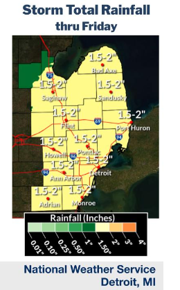
Models tend to overdue the QPF for our area for sure with these large systems. I have learned to cut it in half instantly and even then know that might be the high side. Last weeks big system was forecast to be 1.5"+ QPF but I got under 0.5" from it. This area in SE MI (especially north of I96) does not do as well with these large systems. I believe it has to do with the convection to the south messing with the moisture transport or other dynamics. By the time it gets here it is a precipitation shield is a mess. My hope for 1.5-2" was shattered the moment DTX put this out
-
Pretty darn awesome