Hurricane Agnes
-
Posts
8,877 -
Joined
Content Type
Profiles
Blogs
Forums
American Weather
Media Demo
Store
Gallery
Everything posted by Hurricane Agnes
-
E PA/NJ/DE Winter 2024/25 Obs/Discussion
Hurricane Agnes replied to JTA66's topic in Philadelphia Region
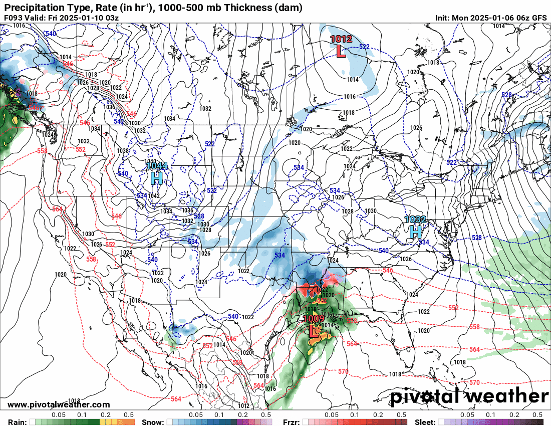
The 6z EC doesn't go out as far as the GFS and has the same GOM Miller A-type thing, but then suppresses the storm, and takes right OTS.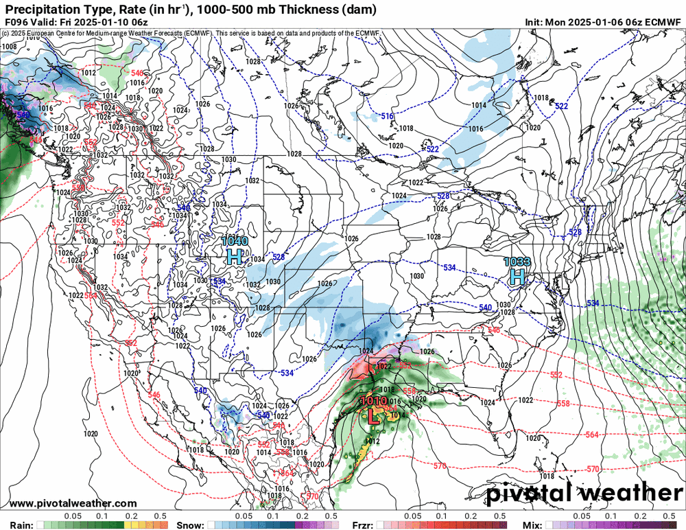
-
1/6 snowstorm - nuisance event or something bigger?
Hurricane Agnes replied to LVblizzard's topic in Philadelphia Region
Have 1/4" here in NW Philly with SN- of very fine flakes, a temp of 24, and dp now up to 21. I expect if the dp continues to rise, the flakes will be enlarged, and it will look "more dramatic". ETA - the untreated parts of the streets have started caving. -
1/6 snowstorm - nuisance event or something bigger?
Hurricane Agnes replied to LVblizzard's topic in Philadelphia Region
This is supposed to go all day... I think you guys are under the WSW. -
1/6 snowstorm - nuisance event or something bigger?
Hurricane Agnes replied to LVblizzard's topic in Philadelphia Region
And the pixie dust snow has commenced - just after 7 am, with a light dusting on cars and untreated surfaces. Dews had been slowly moistening the past half hour and it's now 25, with dp 19. Let the games begin! -
1/6 snowstorm - nuisance event or something bigger?
Hurricane Agnes replied to LVblizzard's topic in Philadelphia Region
LOL As a note, the Philly public schools and Archdiocesan elementary/middle schools are closed today (Archdiocesan high schools are on virtual instruction). The city also closed its offices today as well, interestingly enough. The early '70s was the "snow drought" period with little or nothing really happening until 1978! Didn't stop us from turning on KYW for the numbers though. -
Welcome and look forward to any obs that you have with this current storm!
-
1/6 snowstorm - nuisance event or something bigger?
Hurricane Agnes replied to LVblizzard's topic in Philadelphia Region
Overcast here in NW Philly with virga. Temp is 27 with dry dp of 16. -
E PA/NJ/DE Winter 2024/25 Obs/Discussion
Hurricane Agnes replied to JTA66's topic in Philadelphia Region
Made it up to 31 yesterday with a low of 22. Currently 27, overcast with virga (as the precip shield begins to overspread the city) and with a dp of 16. 6Z GFS has a Miller A-like setup that apparently "misses" throwing any measurable back over the area.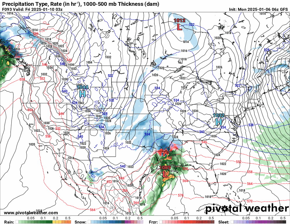
-
1/6 snowstorm - nuisance event or something bigger?
Hurricane Agnes replied to LVblizzard's topic in Philadelphia Region
ICON falling in that same range. I would think the S. Jersey and DE folks will cash in if something warm doesn't advect back in from the ocean.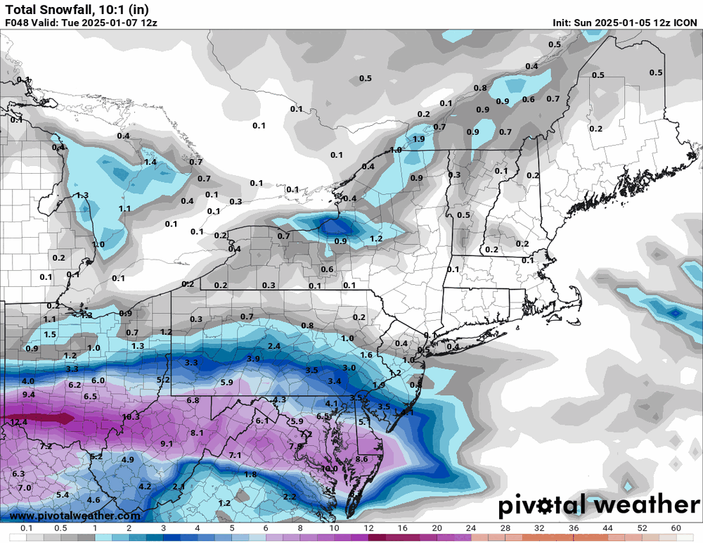
-
1/6 snowstorm - nuisance event or something bigger?
Hurricane Agnes replied to LVblizzard's topic in Philadelphia Region
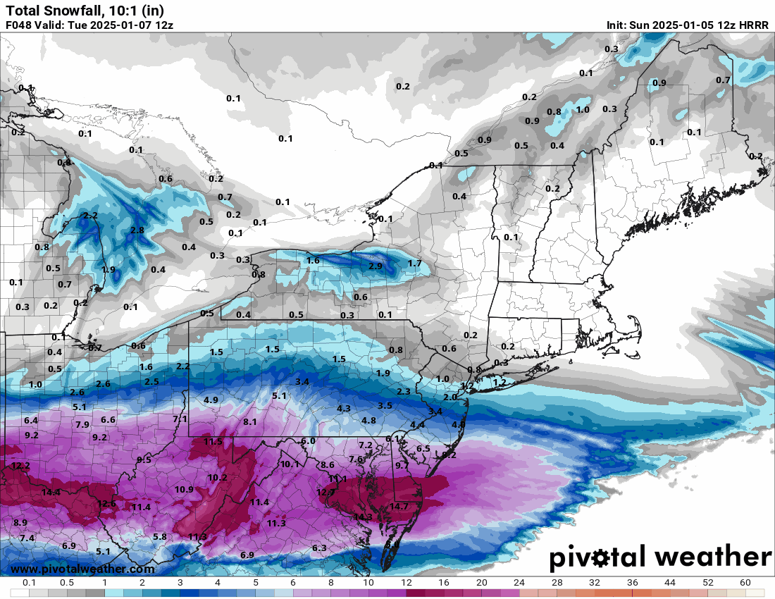
If that jump happens, then there may be some kind of dry slot that helps to reduce totals. The HRRR is probably providing the upper end of the range.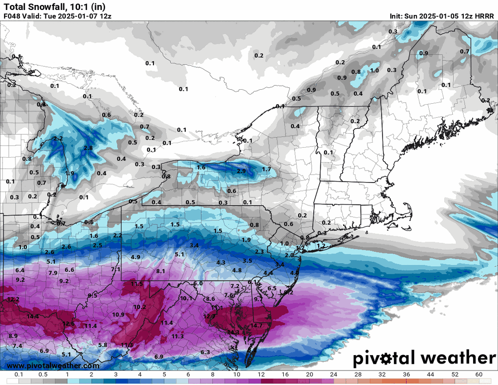
-
1/6 snowstorm - nuisance event or something bigger?
Hurricane Agnes replied to LVblizzard's topic in Philadelphia Region
3k NAM has the Miller B "jump" but then sends the low OTS.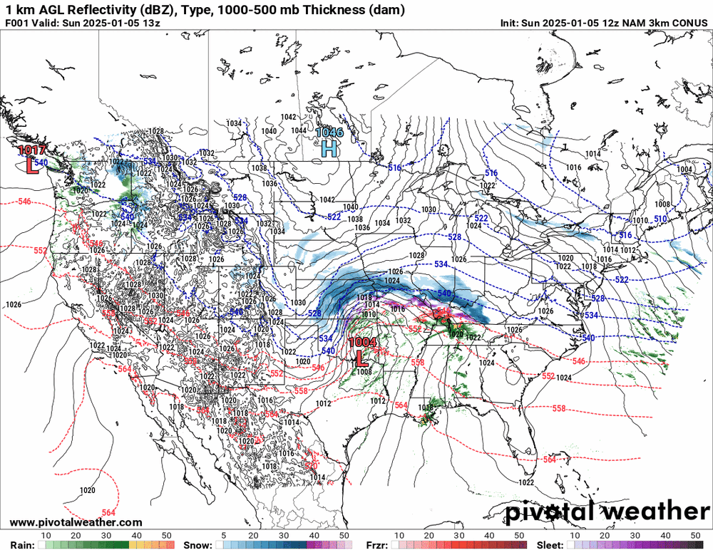
-
1/6 snowstorm - nuisance event or something bigger?
Hurricane Agnes replied to LVblizzard's topic in Philadelphia Region
This is the frame I wanted (48). Definitely un-NAM'd itself.
-
1/6 snowstorm - nuisance event or something bigger?
Hurricane Agnes replied to LVblizzard's topic in Philadelphia Region
Quick 3k NAM frame (although it looks like it might be still snowing at that point - still waiting for some more frames).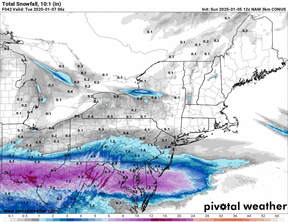
-
1/6 snowstorm - nuisance event or something bigger?
Hurricane Agnes replied to LVblizzard's topic in Philadelphia Region
12z NAM is running so will see how that goes. So far it looks like it is south unless it explodes over the next set of frames. -
E PA/NJ/DE Winter 2024/25 Obs/Discussion
Hurricane Agnes replied to JTA66's topic in Philadelphia Region
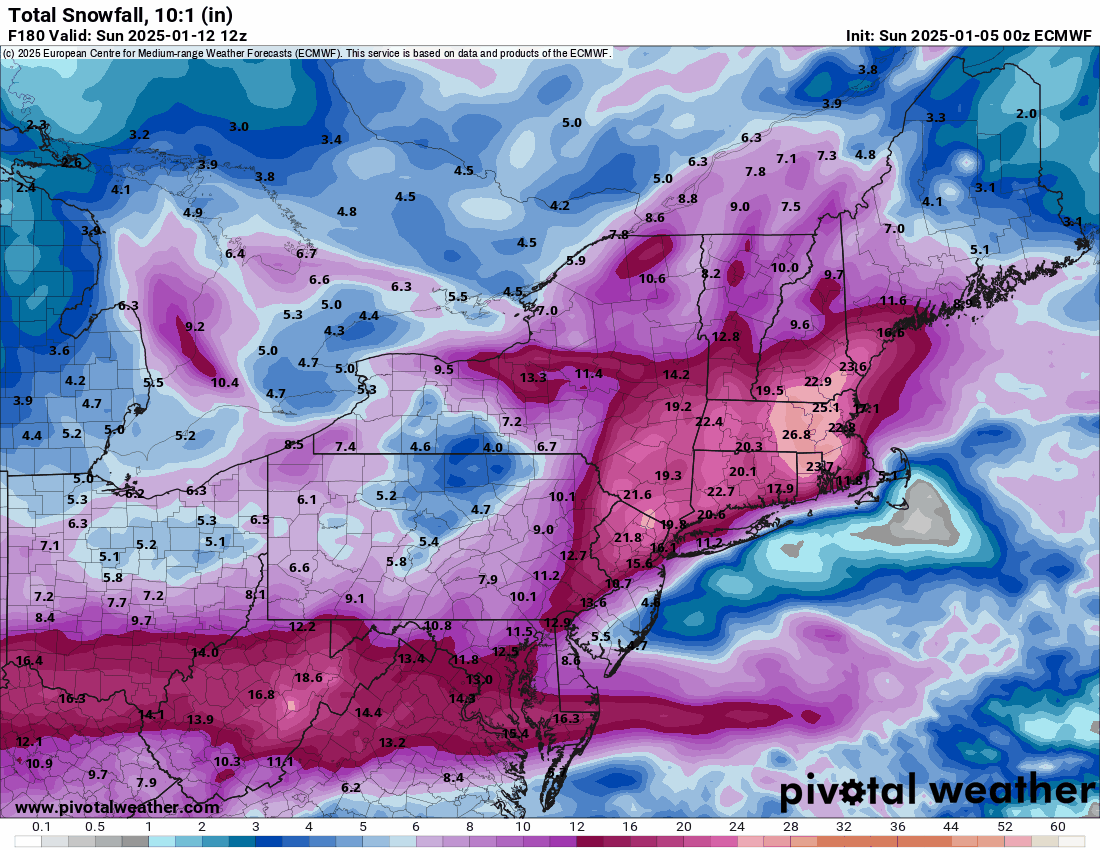
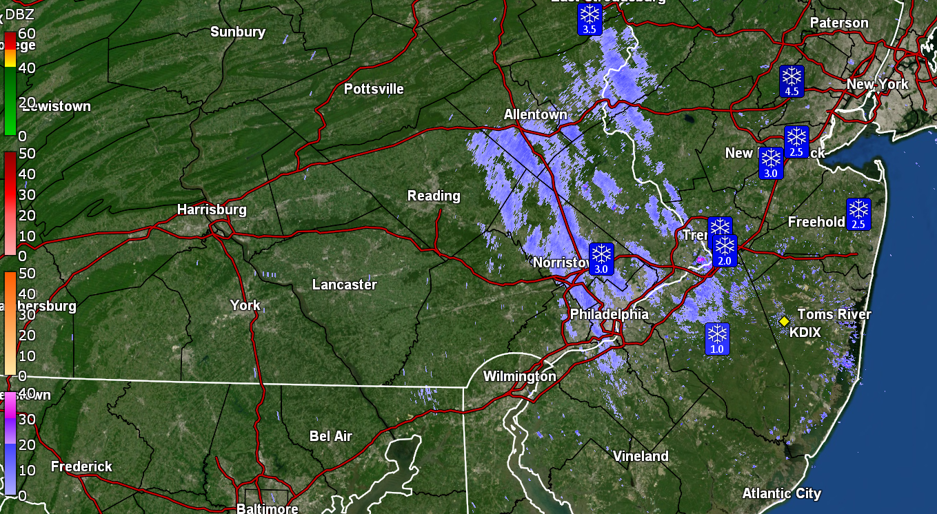
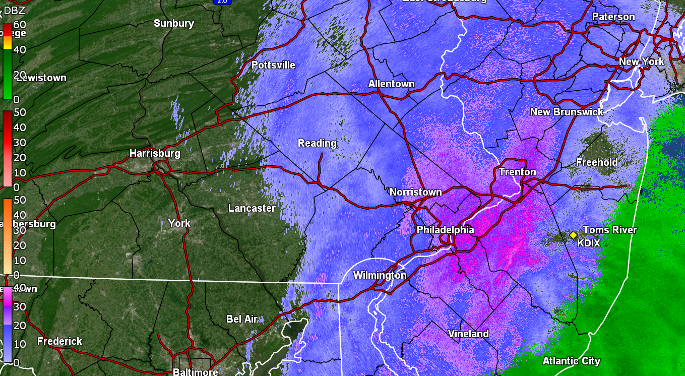
Never made it above freezing yesterday with a high of 30 and low of 25. But the wind and perhaps some insolation were enough to make my 1/2" disappear almost everywhere including grassy surfaces (at least on the S/SW-facing part of the house. The N/NE side still has leftovers). Currently 23 (my low so far this morning) and partly sunny with dp 12. Since the last GFS run was mentioned regarding next weekend, the below caught my attention! (ETA - added the 0z EC for comparison)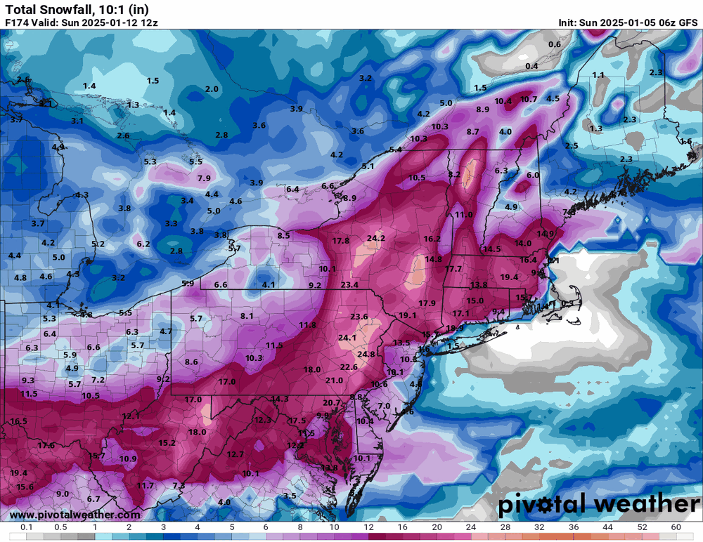

-
January 3, 2025 Light Snow Event Observations
Hurricane Agnes replied to ChescoWx's topic in Philadelphia Region
Looks like it is about done here and I measured 0.5". Temp is currently 31 with dp 30. The paved surfaces didn't really cave much, including non-treated cement like my back patio. -
January 3, 2025 Light Snow Event Observations
Hurricane Agnes replied to ChescoWx's topic in Philadelphia Region
Here I am (I'm still here ). Started getting flakes about an hour ago and it has been sticking on the colder surfaces. So far have a coating of about 1/4" from a fine-flaked SN and temp of 32, with dp 30. Had made it up to 38 for a high after bottoming out at 29. -
E PA/NJ/DE Winter 2024/25 Obs/Discussion
Hurricane Agnes replied to JTA66's topic in Philadelphia Region
Although the radar was "bright" over my area in NW Philly, the snow never got above about a SN- so I just measured 1/4". I didn't see any mixing either nor was there any IP. It is pretty powdery and if there is any wind that picks up it would probably blow away. Currently overcast and 29 with dp 26. -
E PA/NJ/DE Winter 2024/25 Obs/Discussion
Hurricane Agnes replied to JTA66's topic in Philadelphia Region
Have fine flakes going this morning. So far had a low of 23 earlier this morning ~3:40 am, and the temp has slowly been rising since. Currently 27 with dp 22 and a light dusting. That year was awful. As PhiEaglesFan noted, the last time PHL went below 0. It was also the multiple ice storm year when almost all of the commercial and retail salt was gone out of the tristate area and there were "caravans" of trucks of road salt being brought down from NY and other points north. I remember having to go on a work trip during the worst of the ice storms (I think ~Jan. 7 or so) and was headed to 30th St. station to take the train down to Baltimore. I almost went up on the Expressway but thought better of it and continued onto the Kelly Drive and thank goodness I didn't go up there because it ended up completely closed down for hours as cars/trucks got stuck on all the on/off ramps. In Baltimore, I was able to find some bags of Halite, bought a couple to bring home packed in my suitcase, and gave to my mom. She was the only one on her block with a sidewalk clear and dry to the pavement.
-
E PA/NJ/DE Winter 2024/25 Obs/Discussion
Hurricane Agnes replied to JTA66's topic in Philadelphia Region
Bottomed out at 8.4F this morning just after sunrise at 7:25 am. The last time it hit a single digit temp IMBY was December 2022 (with a 5.4F) - literally the same period with a 7.0F 12/23/22 & a 5.4F 12/24/22. Also had the same type of pattern back in 2022 that is progged this year, with a "warm up" around New Years. Am now up to 10 and rising, with dp 3. -
E PA/NJ/DE Winter 2024/25 Obs/Discussion
Hurricane Agnes replied to JTA66's topic in Philadelphia Region
Bottomed out at 14 yesterday and only made it to 22 as a high. This morning, the bottom is falling out (although there is still a light breeze so that might kill any efficient radiational cooling). Am currently 10 with a dp of 4. Humidifiers are struggling. -
E PA/NJ/DE Winter 2024/25 Obs/Discussion
Hurricane Agnes replied to JTA66's topic in Philadelphia Region
Measured 2.70" this morning and bottomed out at 28. There's a streamer of something overhead although it's been mostly virga so far. Currently overcast and 30 with dp 23. Happy first day of winter!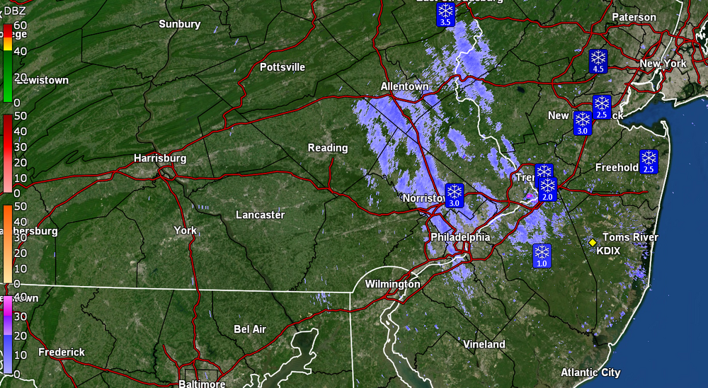
-
E PA/NJ/DE Winter 2024/25 Obs/Discussion
Hurricane Agnes replied to JTA66's topic in Philadelphia Region
I reported just over an hour ago in this thread for where I am in NW Philly up in the hills and had 1" at the time. See below - Just went out again and am now up to 1.75" of paste. This stuff is really wet and is plastered all over the trees and shrubs. Lots of dripping going on as well. The walks are still wet but parts of the streets near the pavement started to cave a bit. Currently 32 with dp 31 and SN-.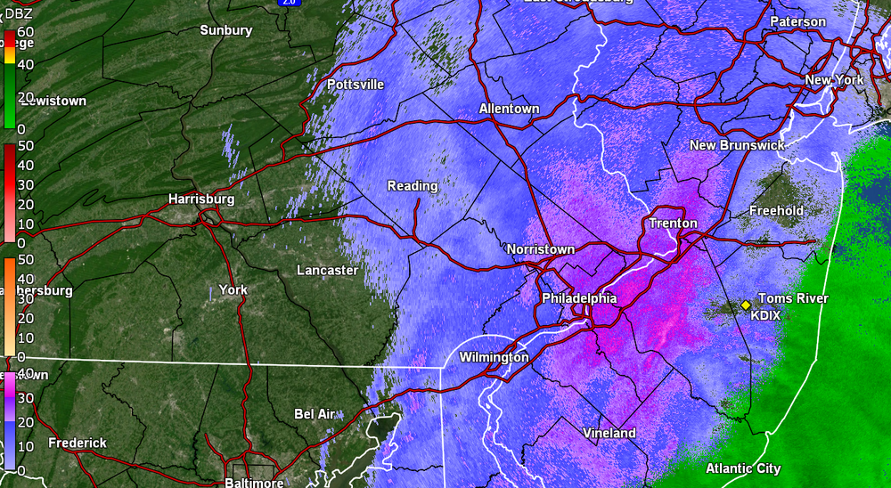
-
E PA/NJ/DE Winter 2024/25 Obs/Discussion
Hurricane Agnes replied to JTA66's topic in Philadelphia Region
Still have SN- to SN and got a measurement of 1" IMBY in NW Philly so far (~8:10 pm). It's wet stuff and there's lots of dripping going on as the temp has been right around freezing. Walks and streets are still wet but cars, grassy areas, and colder surfaces are covered. Currently 32 & dp 32, with light snow and fog.
-
E PA/NJ/DE Winter 2024/25 Obs/Discussion
Hurricane Agnes replied to JTA66's topic in Philadelphia Region
Have a coating on grassy areas and some cars but the walks and streets haven't caved yet. Currently SN and 33 with dp 32.