Hurricane Agnes
-
Posts
8,877 -
Joined
Content Type
Profiles
Blogs
Forums
American Weather
Media Demo
Store
Gallery
Everything posted by Hurricane Agnes
-
E PA/NJ/DE Winter 2023-2024 OBS/Discussion
Hurricane Agnes replied to The Iceman's topic in Philadelphia Region
Hope everyone had a Merry Christmas and with the warm theme, I made it up to 50 on Christmas Eve and 51 on Christmas Day after respective lows of 38 & 39. I have so far had 7.75" of rain for the month of December, definitely making up for the October deficit after a November that made the attempt to do that. Expecting more this week to boot. Am currently at my low this morning of 43 with dp 43 and overcast skies. Haven't really had any fog here as a breeze had kicked up overnight, but there is some low stratus around. -
E PA/NJ/DE Winter 2023-2024 OBS/Discussion
Hurricane Agnes replied to The Iceman's topic in Philadelphia Region
Well my Wed - Fri lows managed to be at or below freezing (28, 32, 28), but this morning's low of 30 was hit at 2:30 am and the temp has crept up since as the air mass modifies. My highs for that period were 44 & 43 but a lowly 35 as a high yesterday as some clouds managed to roll in, and hang around much of the day. MJO has generally been in a state that has impacted northern Europe and Asia but there are progs to head into Phase I some time in the next couple weeks. Will have to see what verifies. It's currently 34 with dp 23 (which ia a little higher than late yesterday when it was headed into the upper teens as the dry air settled in).
-
E PA/NJ/DE Winter 2023-2024 OBS/Discussion
Hurricane Agnes replied to The Iceman's topic in Philadelphia Region
Well the line ended up being virga with a slight uptick in humidity but no visible flakes. Temp still 35 with dp 31.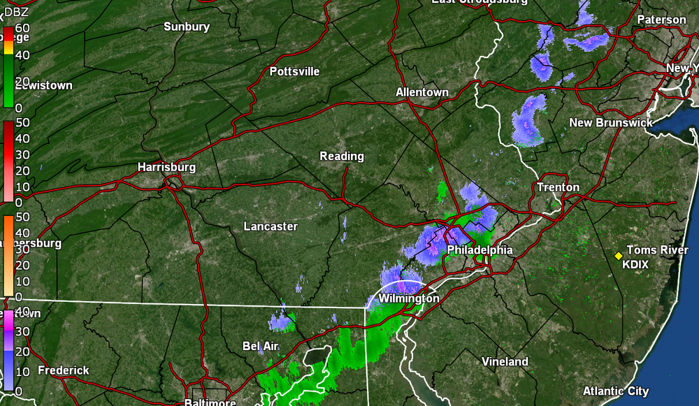
-
E PA/NJ/DE Winter 2023-2024 OBS/Discussion
Hurricane Agnes replied to The Iceman's topic in Philadelphia Region
Some kind of incoming line here. My Delco sis said she peeped out earlier and saw some flakes down in Upper Darby. Keeping an eye on any Trace from it here. Currently breezy and 35 with dp 31.
-
E PA/NJ/DE Winter 2023-2024 OBS/Discussion
Hurricane Agnes replied to The Iceman's topic in Philadelphia Region
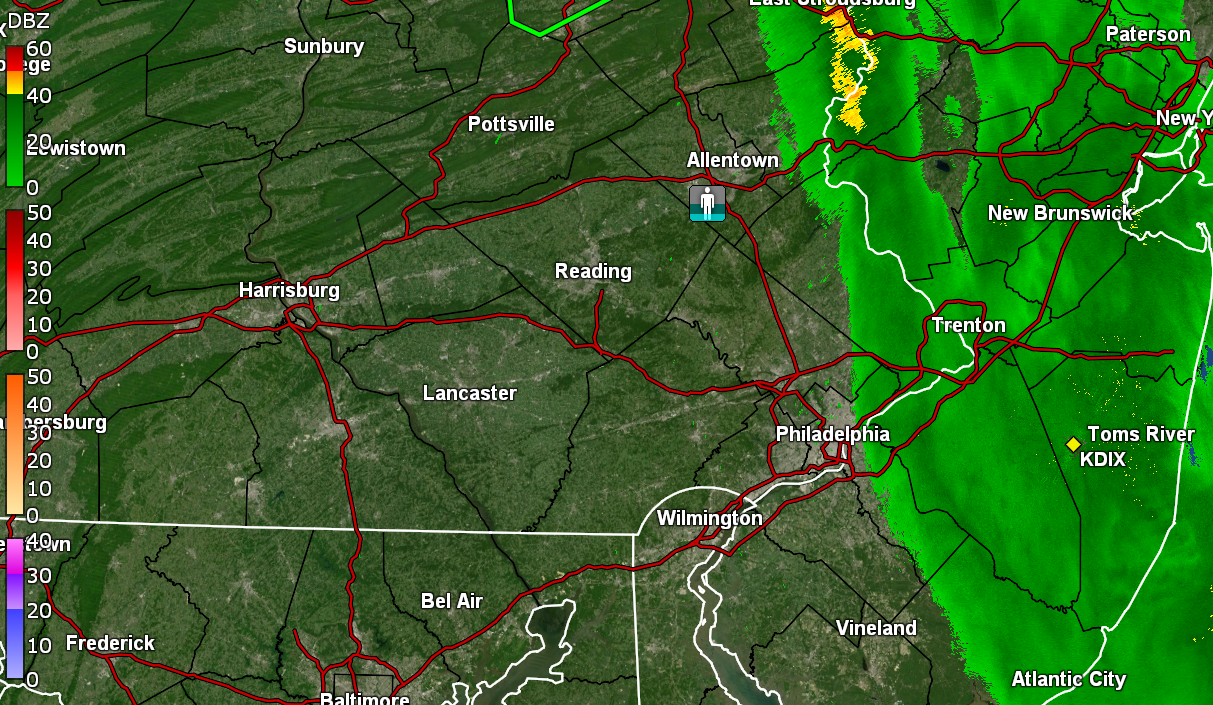
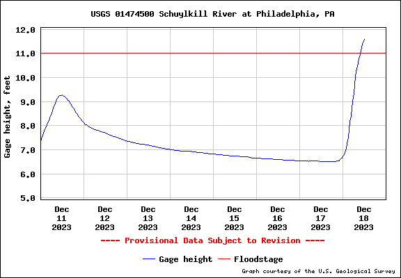
Finished up at 2.54" for the day and 3.93" total for the 2 days. Had an appt. to go to and when I went out to the car, the winds were gusting something fierce. The non-diurnal temp swings continue where it's currently 49 and overcast (dp 45) with a high of 60 earlier this morning. Sharp cutoff obvious on radar. Schuylkill way out of its banks along the drives as of the noon reading.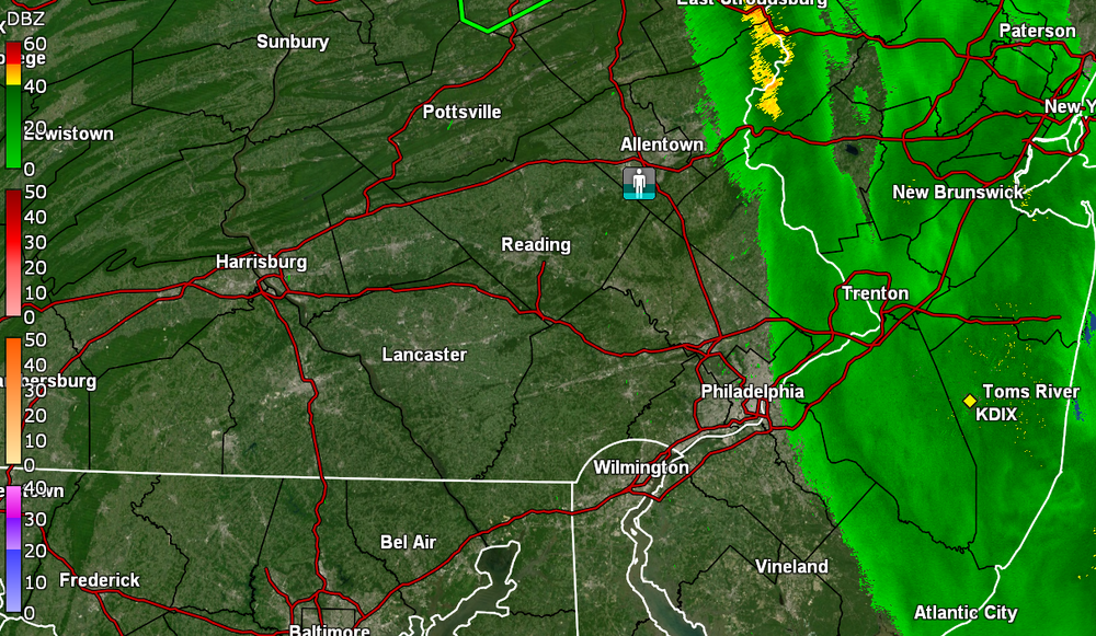
-
E PA/NJ/DE Winter 2023-2024 OBS/Discussion
Hurricane Agnes replied to The Iceman's topic in Philadelphia Region
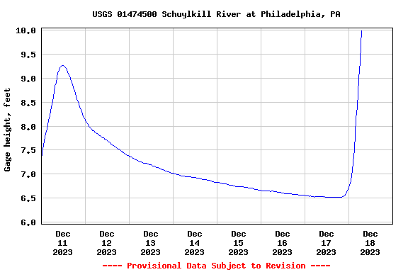
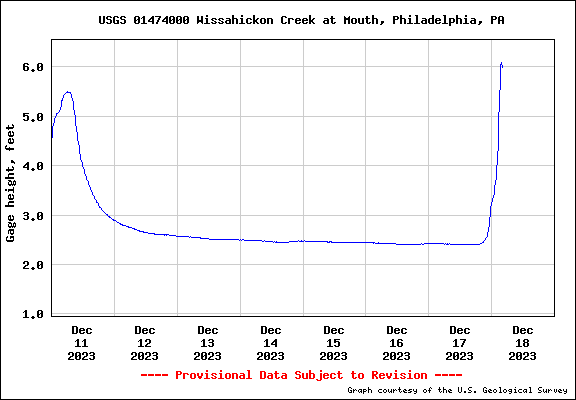
Now up to 2.42" for today (3.81" total for the 2-day event). Temp has dropped off to 52 with dp 52. Flooding reported on Columbus Blvd from South Philly to north of Ben Franklin Br. at Spring Garden (part of that street is below sea level so does get tidal flooding at times). Wissahickon way the hell out of its bank - already over a foot more than last weekend's storm so far and the Schuylkill is about at flood stage.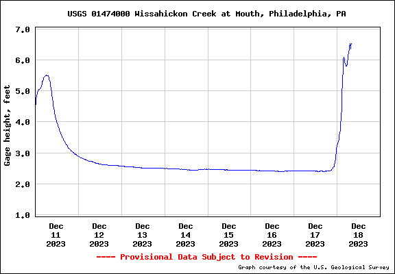
-
E PA/NJ/DE Winter 2023-2024 OBS/Discussion
Hurricane Agnes replied to The Iceman's topic in Philadelphia Region
So far have 1.39" of rain on Sunday and up to 1.84" (at post time) of rain this morning for a 2-day total of 3.23". Non-diurnal temp rise overnight has resulted in a "low" of 58 at midnight. Currently have light rain and 60 with dp 59. ETA - Wissahickon most likely out of its banks (I think flood stage for that is like 5.5ft).
-
E PA/NJ/DE Winter 2023-2024 OBS/Discussion
Hurricane Agnes replied to The Iceman's topic in Philadelphia Region
Astroturf... errr... "FieldTurf" surface there. Slip-sliding away in the rain. Can confirm that 38 was my low this morning and have warmed up to a mostly sunny 50 with dp 36. -
E PA/NJ/DE Winter 2023-2024 OBS/Discussion
Hurricane Agnes replied to The Iceman's topic in Philadelphia Region
Away game in Seattle although they have a similar forecast there for game time - rain and temps in the low-mid 40s (that stadium mostly has a cover over the seating but has the field open to the elements ). Currently sitting at my low (so far) of 39 with dp 31. -
E PA/NJ/DE Winter 2023-2024 OBS/Discussion
Hurricane Agnes replied to The Iceman's topic in Philadelphia Region
Flood Watch coming over the wire - Bottomed out at 32 this morning and hit 54 for a high (so far). Currently 53 and mostly sunny with dp 33.
-
E PA/NJ/DE Winter 2023-2024 OBS/Discussion
Hurricane Agnes replied to The Iceman's topic in Philadelphia Region
One of my neighbors has a ground-cover type hardy geranium still blooming (SW-facing exposure). My highs since Monday were 45, 43, 45, & today 41 (so far). The Tues - today lows were 26, 29, & 27 this morning. The dps have been in the low 20s in any case. Currently 37 with dp 24. Was watching the GFS spin up storms for the rest of the month. -
E PA/NJ/DE Winter 2023-2024 OBS/Discussion
Hurricane Agnes replied to The Iceman's topic in Philadelphia Region
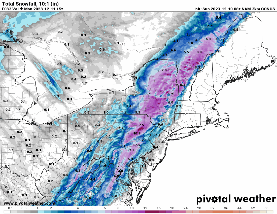
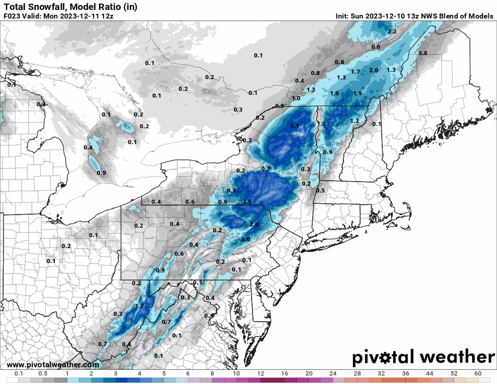
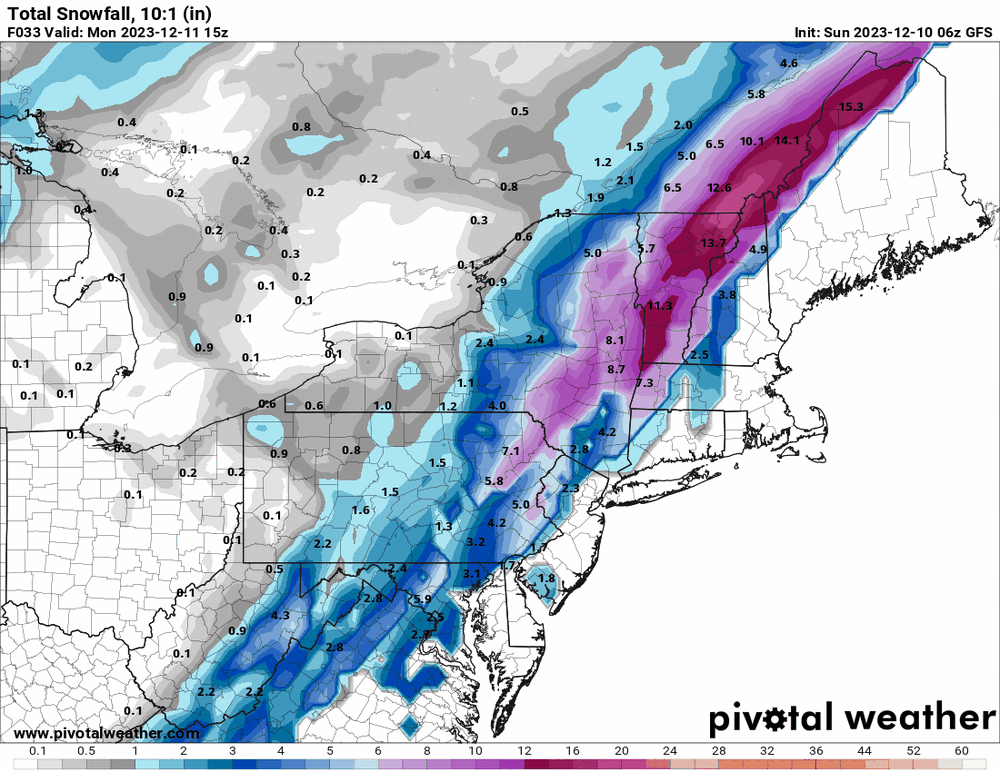
I was posting some of the model maps in this thread and at least for those of us in SE PA and into Jersey/Delaware, the 10:1s weren't showing much, if anything east of Chester County except for the early NAM runs that as predicted, NAM'd people. Currently still breezy and 37 with dp 27. -
E PA/NJ/DE Winter 2023-2024 OBS/Discussion
Hurricane Agnes replied to The Iceman's topic in Philadelphia Region
The 10:1 maps aren't the problem. It's the Kuchera (clown) ones! Of course this early in the season, the chances of getting a 10:1 ratio snow isn't very likely with little or no antecedent cold. With the non-diurnal temp outcome from an overnight CFP, my "high" of 45 was at midnight and I bottomed out at 34 this morning. Currently an overcast breezy 41 with dp 28. -
E PA/NJ/DE Winter 2023-2024 OBS/Discussion
Hurricane Agnes replied to The Iceman's topic in Philadelphia Region
And that's a wrap. Sun out, final rain/snowmelt total for today = 0.63" (2.58" for the 2-day event). Currently a breezy 36, clearing with part sun, and dp 35.
-
E PA/NJ/DE Winter 2023-2024 OBS/Discussion
Hurricane Agnes replied to The Iceman's topic in Philadelphia Region
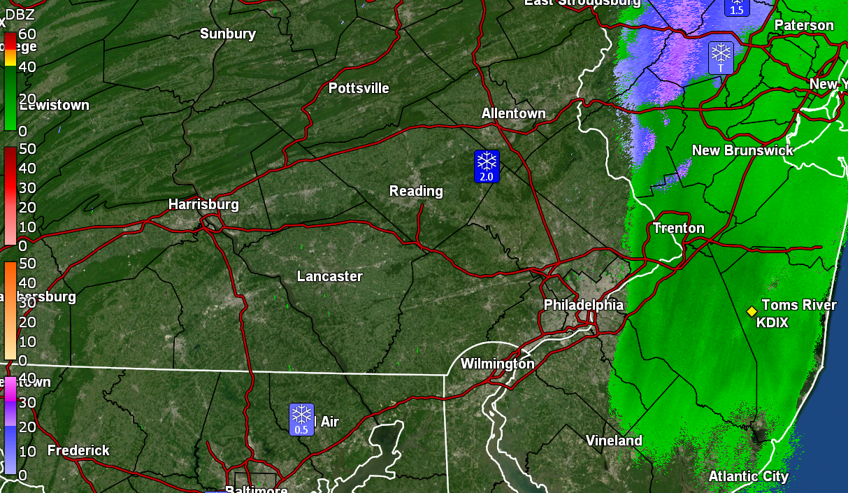
Still have a rain/snow mix here blowing out of the NW, although the flakes aren't the pancakes from earlier. Am up to 0.53" for the day so far (2.48" 2-day rain total). Flooding has Lincoln Dr. closed and the Wissahickon Creek is definitely out of its banks! Currently 35 with dp 34 with light rain/snow mix.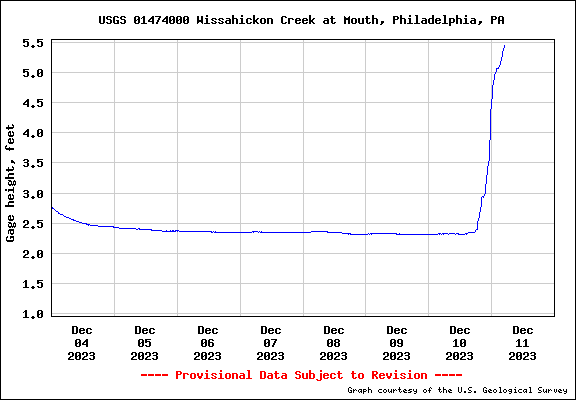
-
E PA/NJ/DE Winter 2023-2024 OBS/Discussion
Hurricane Agnes replied to The Iceman's topic in Philadelphia Region
Can confirm fatties in the air here and KYW traffic reporter mentioned lower visibility on the turnpike to the west and also up north in the LV. Currently 35 with a light rain/snow mix (now at 0.47" for the day) and dp 35.
-
E PA/NJ/DE Winter 2023-2024 OBS/Discussion
Hurricane Agnes replied to The Iceman's topic in Philadelphia Region
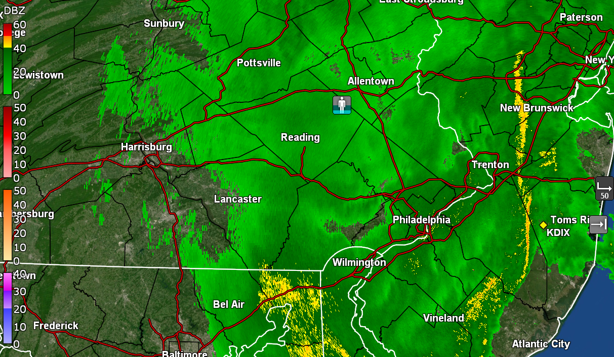
With the non-diurnal temp swings yesterday, my "low" for yesterday ended up being just before midnight with the cold front having moved through, and after a high of 61. Ended up with 1.95" of rain yesterday plus an additional 0.43" (so far) today, for a 2-day total of 2.38" of rain. Currently light rain and 37 with dp 37. -
E PA/NJ/DE Winter 2023-2024 OBS/Discussion
Hurricane Agnes replied to The Iceman's topic in Philadelphia Region
Just hit the 1.00" mark with about 1/3rd" rates. Temp holding at 60 with dp 60. -
E PA/NJ/DE Winter 2023-2024 OBS/Discussion
Hurricane Agnes replied to The Iceman's topic in Philadelphia Region
Heavier rain band has been backing in from the SE with a SW flow.. Now up to 0.58" with >1.3"/hr rates. Temp has crept up to 61 with dp 61. -
E PA/NJ/DE Winter 2023-2024 OBS/Discussion
Hurricane Agnes replied to The Iceman's topic in Philadelphia Region
The early rain shield has big gaps and I'm currently at 0.17" (just ticked over since it started raining again after a lull). Currently have light rain and it's 60 with dp 59. -
E PA/NJ/DE Winter 2023-2024 OBS/Discussion
Hurricane Agnes replied to The Iceman's topic in Philadelphia Region
Finally got a bucket tip to 0.01" as the rain shield moves closer. Still 59 with dp now 59 and overcast. -
E PA/NJ/DE Winter 2023-2024 OBS/Discussion
Hurricane Agnes replied to The Iceman's topic in Philadelphia Region
12z GFS drier than the NAM in the southeast. ETA - the latest NBM is going with the drier (more rainy/less snowy) solution for the southeast. Currently wet (non-measurable so far) and 59 with dp 58.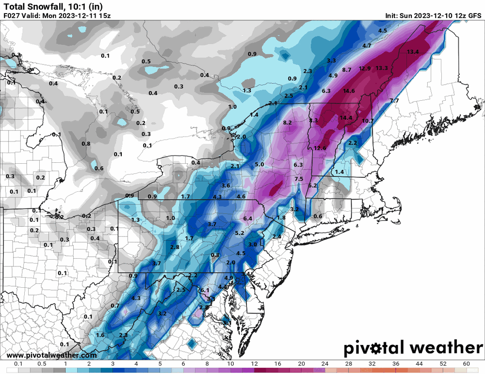
-
E PA/NJ/DE Winter 2023-2024 OBS/Discussion
Hurricane Agnes replied to The Iceman's topic in Philadelphia Region
12z 3k NAM just rolled out and throws a bit more to the east. ETA, I'm now at 60 with dp 57.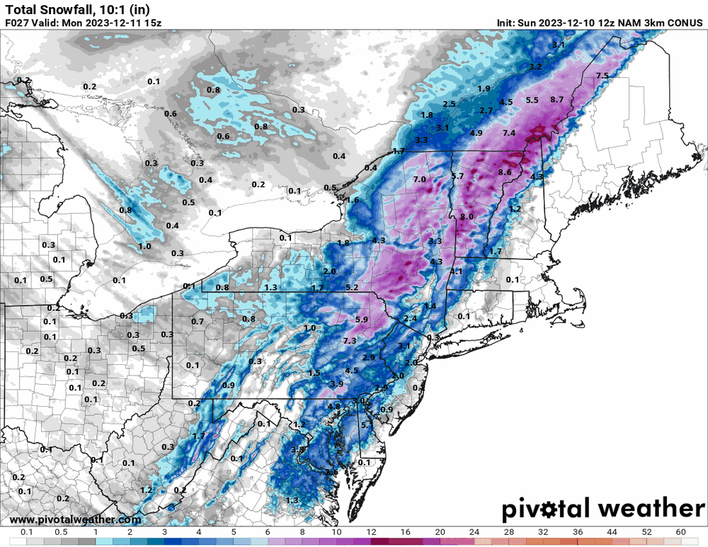
-
E PA/NJ/DE Winter 2023-2024 OBS/Discussion
Hurricane Agnes replied to The Iceman's topic in Philadelphia Region
Temps have been rising overnight so my "low" was 47 at midnight (assuming the cold front doesn't come through until early tomorrow morning). It's currently 57 with dp 55. Looks like the 6z 3k NAM un-NAM'd itself and threw most of the precip to the N/W with a little to the E/S. ETA 6z GFS throws a little more to the east.
-
E PA/NJ/DE Winter 2023-2024 OBS/Discussion
Hurricane Agnes replied to The Iceman's topic in Philadelphia Region
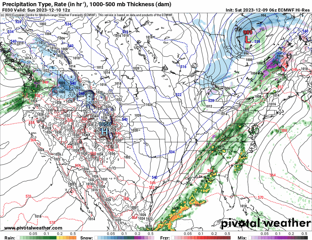
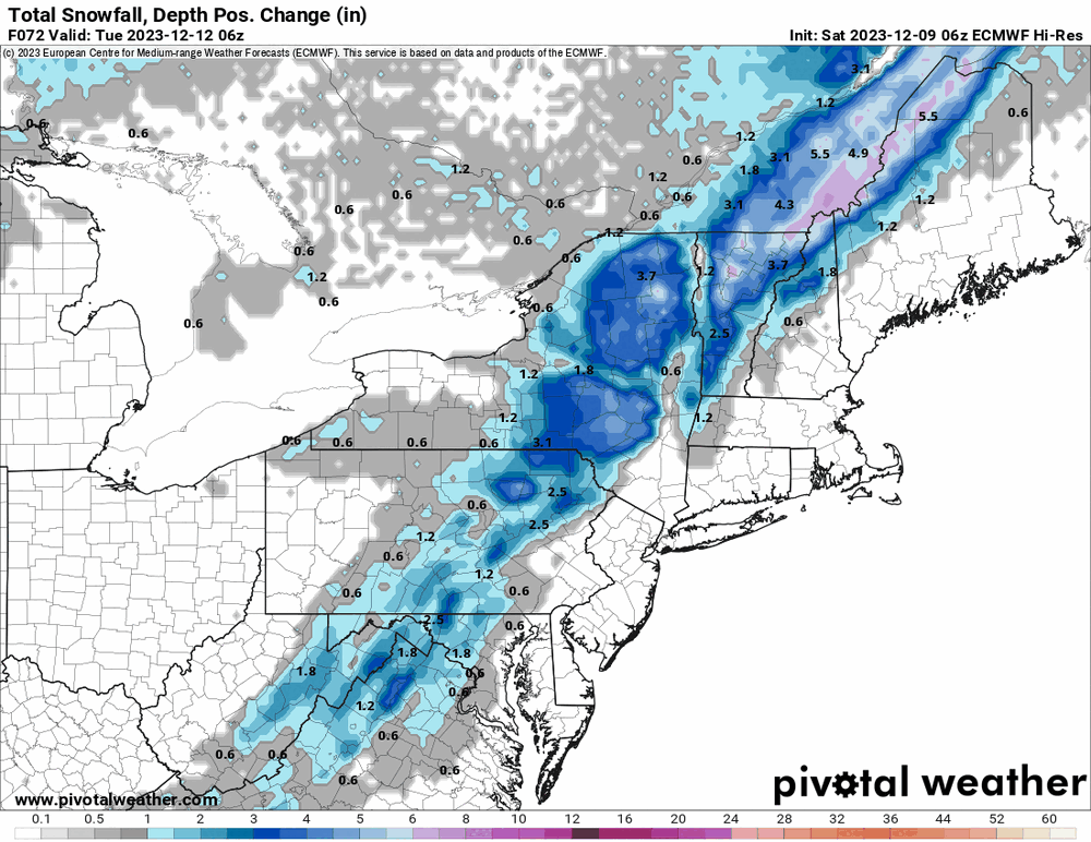
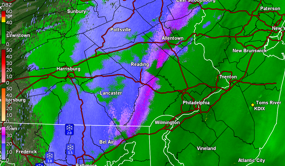
Bottomed out at 37 this morning and the fog/low stratus was thick but much of that has lifted now although it is still misty and overcast. Currently 44 with dp 44. 6z hi-res Euro does throw a changeover into the mix for tomorrow. I noticed what was originally a more inland low has been pushed east and at least according to the Euro, may bomb out when it gets off the coast of NE. However it looks like the accums would still be N/W with the colder air.