Hurricane Agnes
-
Posts
8,877 -
Joined
Content Type
Profiles
Blogs
Forums
American Weather
Media Demo
Store
Gallery
Everything posted by Hurricane Agnes
-
My windows are steamed up and it's 77 with dps in the mid-70s. The only thing that makes it "not too bad" at the moment (had to go outside and add some nectar to my hummingbird feeder) is that the sun isn't blazing yet here due to a high deck of clouds. Soon as that sun emerges, look out!
-
Back edge is coming through now but eventually got over 1"/hr rates with a gully washer but just for a couple minutes. So far have 0.25" from it (at post time) and the temps were knocked down almost 10 degrees to 73. That + hot asphalt, hot cement, hot brick and stone, and hot metal will = sauna for the next couple days.
-
Mt. Holly had a SPS up for this. Didn't really expect anything tonight although the chances were out there (good thing I threw some fertilizer out on the plants).
-
Wow. That little piece of cell means business. Almost up to 0.30"/hr in the last minute or so. ETA - now up to 0.57 inches/hr! Holy crap!! ETA now at 0.64"/hr.
-
About to get hit with that partially-redeveloped squall line. Have been hearing thunder and getting lighting in the past 5 minutes or so. Temp is 82 and it's overcast.
-
Managed to briefly make it up to 93 here today with enough mixing to keep the dews in check in the low 60s. I expect that ends tonight and definitely tomorrow. Currently 89 and partly sunny with a high deck of clouds starting to move in.
-
It hit 90 just after noon time here today and is creeping up. The dp was higher earlier this morning (mid-60s) but has mixed out some thanks to an occasional few puffs of breeze and dropped to the low 60s. Currently 90 with almost all blue sky except for a few small cumulus starting to form off to the east.
-
Today actually turned out to be the "comfortable" day with dews in the mid-upper 50s. But I think we're done with days like this until probably September. Currently 83 after a high of 87 here today, with scattered cirrus clouds and plane-generated contrails most of the day.
-
Made it to 90 yesterday and by that late afternoon, it was blast-furnace feeling as the dews were creeping up ahead of the front. Different story this morning with the dp @ 56 and current temp at 71. I did a search for past data for PHL and apparently the last time we hit ("official") triple digits in the city was 7/7/2012 (101), so it has been awhile. Seems that whenever we have antecedent wet periods, it takes really sustained high temps to dry the surface enough to get to a triple digit high.
-
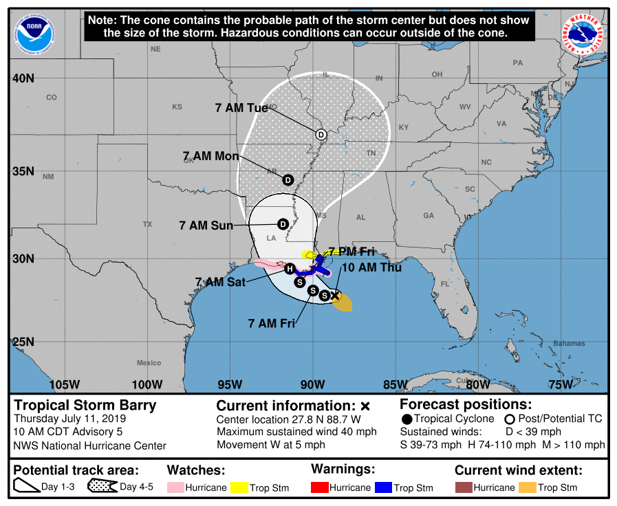
Barry now upgraded to a hurricane with the latest advisory (just posting summary of it with position) - Meanwhile, current temp here is 82 with dp that has been slowly rising this morning (up to 67). Yesterday had a high of 88 with dews in the low 60s and a breeze, so pretty nice.
-
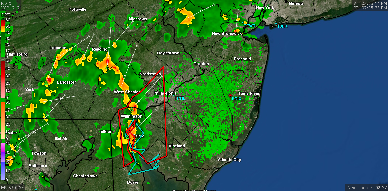
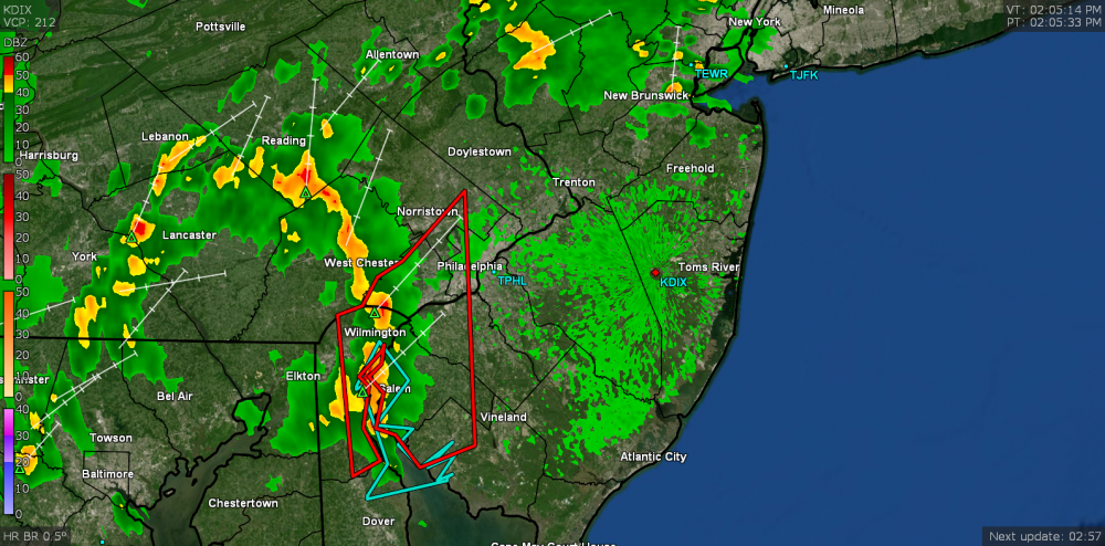
Got 1.19" out of round 2 so far for a total of 1.72" for today's event. There looks to be some more scattered rain to the west that might add to that if it holds together. Currently 71 with some light rain.
-
Currently under the heavy band and just hit the 1.50" mark total so far for the day (0.97" since round 2 began). Temp is down to 71 with moderate - heavy rain with occasional thunder.

-
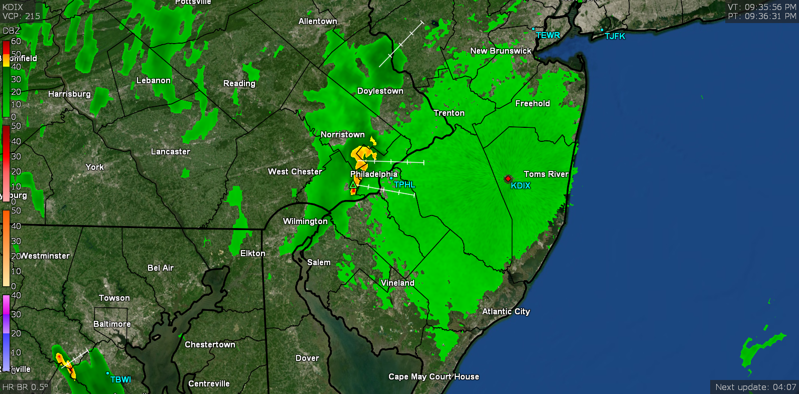
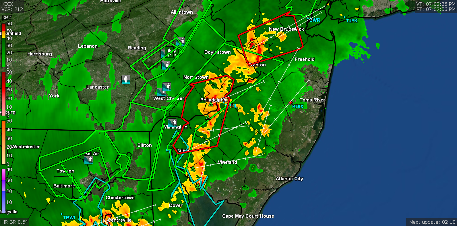
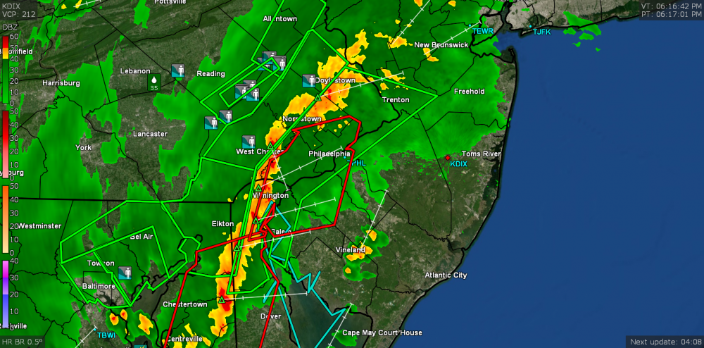
EAS for Flash Flooding and Severe Thunderstorm Warning up (including my area). Currently at 0.66" and it got dark real fast. Looks weird and the windows are steamed!
-
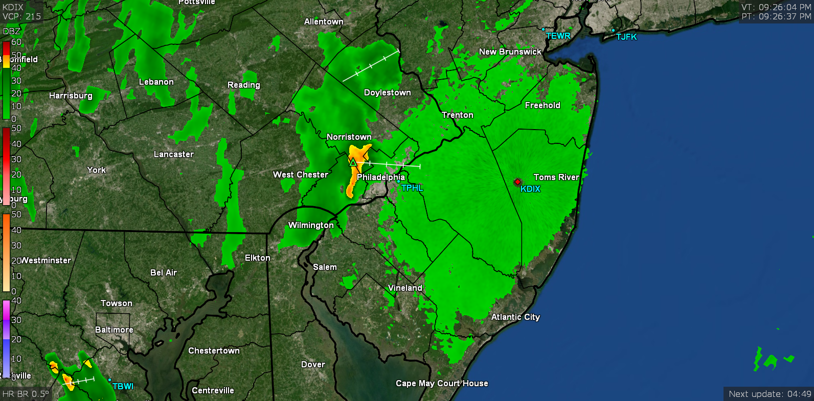
Hearing thunder again with the leading edge of the heavy precip line coming into my area. Already added 0.11" to my earlier 0.53". Currently 75 with varying light - moderate rain.
-
Got 0.53" so far out of that round with 2"/hr rates for a time. It just steamed everything up big time now. Temp is currently 75 with light rain and dps in the mid 70s now.
-
Now getting gully washer rain. Temp is down to 79.
-
Now getting rain. Not gully washer yet but pretty heavy. Temp hit 88 before the clouds lowered it and now the rain taking it down more. Currently 84 with heavy rain. Up to 0.07" at post time (no thunder/lightning yet).
-
Severe Thunderstorm Warning was issued and I am literally right on the eastern line of it (the radio activated for it).
-
TS Barry has arrived (abbreviated) -
-
After a low of 70 this morning, was already up to 84 by 9:30 with a dp of 69. You can definitely feel the juiced up difference this morning versus yesterday. Currently 85 and partly sunny as the clouds start to roll in and thicken. I see a NW-to-SE-oriented line to the west slowly pushing to the east, so it won't be long (assuming that holds together).
-
Made it to 91 today just before 3 pm and with the dews in the mid-60s, you could feel a bit of humidity but it still wasn't too bad thanks to a light but active breeze. Currently mostly sunny and 87.
-
Just fell short of 90 today (high of 89) but the dp had a low around 57 but has since crept up to the low 60s later this afternoon and you could feel the difference (although still not like last week). Currently 82 and partly cloudy.
-
I actually heard my first cicada July 4th morning. Still haven't heard any crickets yet but they should be out and about soon.
-
Well after on and off light rain this morning, the sun is now coming out (or at least trying to). Picked up 0.15" from the intermittent showers. Dews are down in the lower 60s so much better than the past couple days but still a bit sticky with the rain. Temp has stayed around 70/71 most of the day (low was 69 at one point) but it is now up to 73 and generally overcast with some breaks in the ceiling for the sun to pop in and out.
-
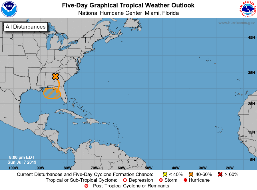
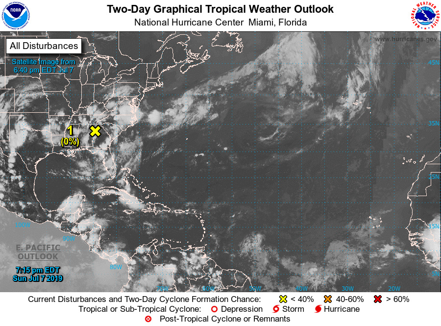
They (NHC) have a little discussion on it here - https://www.nhc.noaa.gov/gtwo.php?basin=atlc&fdays=5