Hurricane Agnes
-
Posts
8,877 -
Joined
Content Type
Profiles
Blogs
Forums
American Weather
Media Demo
Store
Gallery
Everything posted by Hurricane Agnes
-
I ended up with a few more late showers overnight giving me a total of 0.27" yesterday. Had some more scattered showers just after midnight for another 0.04" for today (so far). Ended up just hitting 70 today for a high around 4:30 pm after a low of 60. It was overcast and breezy most of the day although the sun was trying to break out earlier this afternoon giving me that 70 high but then it got obscured again. Currently 68 and overcast.
-
It dropped my temp down to 73 and I ended up with 0.25" of rain (it was a relatively fast-moving line). Look forward to putting the oven on tomorrow (have been avoiding using the oven most of the summer)!
-
Have been fringed or entirely missed the past couple storms until now! High today was 87 after a "low" of 74. Currently 84 and dropping with a gully washer (have 0.18" do far at post time).
-
2019 Atlantic Hurricane Season
Hurricane Agnes replied to AfewUniversesBelowNormal's topic in Tropical Headquarters
Although I know these models often have fantasy stuff in the long range, sometimes they do latch onto the right solution but for the wrong reason during that timeframe. The mid-range is when you see them go all "opposite" of what they hinted at in the long range though. -
2019 Atlantic Hurricane Season
Hurricane Agnes replied to AfewUniversesBelowNormal's topic in Tropical Headquarters
Neither the 0z or 6z GFS have the storm until days later and then roll is right out to sea.
-
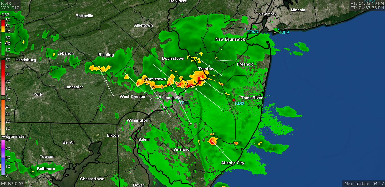
That cell was lighting up the sky here but was too far to the south & west of me to get anything from it. This is where it moved when I saw the sky lit up -
-
Was just looking at that in the Atlantic Hurricane thread. Am hoping that doesn't verify (although the Euro hasn't done that well with 'canes).
-
Made it up to 88 today (but not until 4:30 pm), and with ugly dews in the low 70s, but interesting that it is still 81 out right now. The temp was slow to rise here this morning so didn't expect to hit the big 9-0. Will be interesting to see if it gets closer to it tomorrow. There's a little blob on the radar headed this way but I expect it'll either fizzle or fringe me. ETA ~8:45pm - am seeing lightning flashes way off to my south. lol

-
Here is an article on the follow-up of that -
-
-
The issue of "threat" (and "risk") will always be "mush". And mainly because it becomes a damned if you do, damned if you don't scenario when you attempt to definitively characterize something and you end up being "wrong" because of an outcome that went to the other side of the "wiggle room" spectrum (probability range) from what was expected. It's akin to teasing out the degrees of difference between near-synonymous words like "shall", "should", "will", and "must". The hope is to be able develop tools to help reduce the probability range. There is a similar issue that goes on with the aftermath of an EFx tornado vs straight-line winds. There has been tremendous damage done to infrastructure from straight-line winds akin to tornado damage, but the mechanisms (and debris patterns) behind either phenomena are different and this often triggers public frustration on what to call the "cause" of the damage they might experience or have experienced. I.e., the public is more familiar with the term "tornado", whereas "straight-line winds" is a more nebulous term and is often automatically considered as "less than a tornado", yet the damage can be the same or even worse. This is not so much a scientific issue as it is a "perception" issue that happens with media reporting. The implementation of the "key" things to know - notably the potential "impact", is a good step in the right direction (knowing however that the average person is not visiting the point-and-click maps on the NWS site for their locations to read the actual warning text and are usually getting their weather news filtered by the media on TV, radio, or even from a smart-device weather app). I really don't think there is a good way to resolve this (at least off the top of my head and in a manner that doesn't introduce a dozen technical terms for damage-causing "storms" - not unlike differentiating hail from sleet... or snow from rimmed flakes or graupel... let alone explaining the ice caused by freezing rain when the air temperature is above freezing). One thing that I thought was pretty cool that NHC had done was the creation of an animation illustrating the type of damage a hurricane of "x" range of wind speed could generate. Unfortunately it is a flash animation (and really should be converted to something like an animated gif or perhaps a HTML5 animation), but can be found here as a standalone - https://www.nhc.noaa.gov/animations/images/hurricane_winddamage.swf (and is also embedded here - https://www.nhc.noaa.gov/aboutsshws.php) This type of illustration could actually apply to any type of system that produces extreme winds (whether hurricane or tornado or straight-line winds, etc). The visualization pretty dramatically illustrates wind force and its potential impact (assuming the infrastructure wasn't already compromised by age or other factors). But it would also behoove the media to pass this type of thing along as well, perhaps as a public-private partnership/collaboration. As it is, there is quite a bit of rancor that goes on between the private forecasters and the public ones and this sadly tends to cloud (pun intended) the issue of communicating hazards as well.
-
Ended up with a high of 82 yesterday after a low of 64, so overall, not a bad day. This morning is starting out warmer with a low of 69. Doubt I will get to 90 today but that may depend on the cloud cover and whether the SW flow gets going in earnest here. Current temp of 72 and partly sunny.
-
I think realistically, there isn't much if any difference between a high-end CAT 4 and a low-end CAT 5, as these terms are nothing more than artificial constructs for data categorizing purposes, where in either case, the potential damage impact is the same - catastrophic. Since "CAT 5" is the highest designation for the scale, it behooves balancing the "drama" of the term with the confirmation that it is truly sustained at that level, as there is no other category "officially" above that level. And when conditions are at the threshold of either designation and one is trying to communicate that to the public, it requires extra care to assess the risk of what might be confusing frequent category changes, while working around the media's propensity to exaggerate (for ratings). So there is a need to confirm, without doubt, that the category has truly been achieved and sustained, again with the knowledge that whether it is a high-end CAT 4 or a low-end CAT 5, the damage is the same. I do expect like what was done with the "S word" storm in 2012, there will be a "Lessons Learned" activity as part of the full reanalysis of this storm. NHC took a big hit because the existing criteria was correctly followed when that storm became post-tropical and was no longer considered a "hurricane" ("hurricane" being a term very recognizable by the lay public). However public outrage ensued because anything less than the use of that term for a storm with equivalent winds/rain/surge and damage impact, became unnecessarily confusing to the public due to the focus on the technicality of "tropical" vs "post-tropical". I.e., to the scientific met community, that storm's technical makeup and dynamics had changed ("quantitative"), but to the public, the "look" and "feel" and "impact" had not ("qualitative"). And now with climate change altering storm behavior, we are seeing storms maintain tropical characteristics further north in latitude than in the past, often due to a warmer ocean further north. So in a similar fashion, they may look at ways to more quickly but definitively declare a storm as having achieved that highest category (outside of reported wind speed at the surface through dropsondes) without compromising the science behind the confirmation. I think this would really be a good idea to do given the sudden increased frequency of such storms (and as we know here, this was the 5th one in 4 years, where in the past, this level of storm was more rare). You might recall the same issue with Hurricane Michael and a decision, after a post-storm reanalysis, to upgrade it to a CAT 5 at landfall.
-
Here is a heartening response from the NOAA Oceanic and Atmospheric Research (OAR) group - https://www.research.noaa.gov/article/ArtMID/587/ArticleID/2489/A-Message-from-Craig-McLean-Hurricane-Dorian-and-Exceptional-Service
-
I agree we probably should but it will be doubtful that it would be done. If anything, they might consider going as far as making it a "standalone" (like EPA) or even like FEMA, particularly after the fiasco of FEMA when it was neutered after being shoved under DHS, later prompting Congress to make them a standalone agency again. In fact, since I mention EPA, they should probably be included in some standalone grouping with NOAA and USGS as you suggest.
-
Most likely because what they do involves monitoring conditions that might impact movement of goods - i.e., shipping (whether over land, in the air, or at sea).
-
In reference to the NWAS meeting going on - some tweets of note - The above in reference to NWS head Dr. Uccellini's remarks this morning regarding his public support of the Birmingham FO (video of those remarks in the tweet below and he got a standing ovation near the end of his speech when he explicitly praised the staff for doing the right thing) -
-
The agenda for Tuesday is here - https://nwas.org/annual-meeting-events/annual-meeting/meeting-agenda/#tuesday-glance And it looks like a pretty tight schedule. Dr. Jacobs has a 30 minute slot and then someone else is on at 8:30 am (someone presenting a research paper), so I doubt there will be any Q&A associated with his remarks. Usually keynotes at professional meetings don't have Q&As and tend to run 45 minutes or more (and often occur in a "prime time" morning slot or as part of a dinner), so this seems pretty "short" to be considered "keynote" outside of them calling it that due to his position in public service... and they have other folks scheduled to give "keynotes" after him.
-
I kinda thought the same thing. Got up to 82 here too, which was my high (after a low of 65). It was overcast earlier this morning but once that went away, the temps started shooting up (as did the point and click forecast temp). It's been back to overcast the past hour or so now and the temp is down to 78.
-
-
-
Josh started a first-person account of his Dorian experience via a twitter thread. Here is a link to the unrolled version (with 5 tweets so far) - https://threadreaderapp.com/thread/1170675844815216640.html
-
I finally ended up with 0.20" of Dorian rain with the last of it coming through just after 10pm. But wow.... didn't realize it was going to chill down this much. My high yesterday was 68 and the low ended up at midnight at 58. But this morning it is currently down to 55 and that brush with Dorian yesterday felt like a chilly nor'easter vs a steamy tropical hurricane I guess due to it pulling down some cold Canadian air when it got sucked into the trough. Definitely a "trigger" for plants and animals that fall is coming (and I know Birds~69 is loving it ) although it's supposed to warm back up into the low - mid-80s next week.
-
And as expected, as Dorian continues to move away, that band pivoted around and swung back over me from the NW and I am now up to 0.18" with some light rain still going on. This is probably the "coldest" tropical storm that I've ever experienced. LOL Temp is now down to 58.
-
Am now up to 0.17" so far from that band. The band has moved away to the NW of me as Dorian lifts to the NE and starts it's trek away from the coast, so it's possible that the little band may pivot around and move back down here from the N and then from the NW before it pulls completely away and is history. Currently 59 and overcast.