WxSynopsisDavid
-
Posts
500 -
Joined
-
Last visited
Content Type
Profiles
Blogs
Forums
American Weather
Media Demo
Store
Gallery
Everything posted by WxSynopsisDavid
-
I remember leading up to this past Friday, the HRRR had a few runs where it did that early on but corrected within 18hrs to the start of convection. Also not the first time I've seen the HRRR do this, seems to be a typical bias of the model.
-
Great analysis and comparison there. With the fail modes in place, April 7 2020 could be the floor. I still believe tonight's event was the "fly in the ointment" that caused the CAM to back off a tad with concerns to Tuesday. Interesting to note, the EURO stuck to the scenario and the RAP and now the HRRR are caving towards the EURO scenario. Will be interesting to see how tomorrow's convection impacts the environment for Tuesday.
-
That's a substantial trend higher with STP compared to previous runs. Seems like the CAM is having a better handle/grasp on Tuesday now that tonight's event is wrapping up.
-
I should of chose better terminology when I said struggling. My apologies, but yes I am in agreement with that. Correct me if I'm wrong but the more high-end, severe outbreaks we seen in years past always featured a short wave out ahead of the dryline, early day surface low or mcs, to help breach the cap and lay down boundaries to set off convection.
-
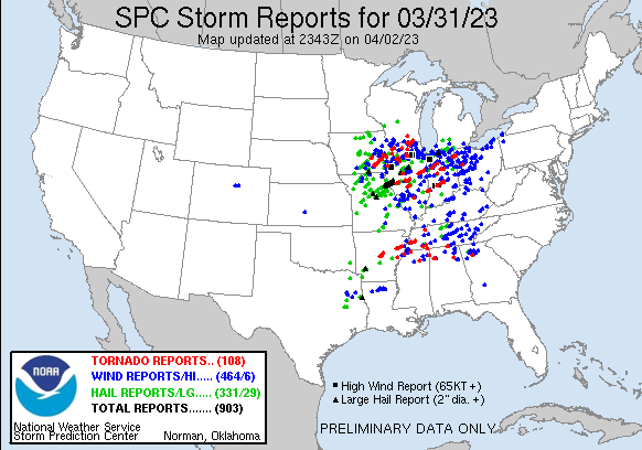
Factor in the stuff from 3/31 and yes. But concerning 4/1, there's a gap in central PA where there were no wind reports.
-
Here's another potential thing to think about. The "fly in the ointment" was tonight's event when models started to show a much more significant event for today they backed off for Tuesday. Considering tonight's event underperformed, I wonder if the models will start to go back to a more high end solution for Tuesday with these capping issues and mixing/lcl issues resolved.
-
Main issue the models been struggling with is the cap. Some models like the RAP now showing the cap being breached hours before sunset. EURO been showing this however. Others like the NAM and HRRR breach the cap at or just after sunset. Interesting to point out, both the EURO and RAP are different in how the cap breaches.
-
Big tick upwards in parameters on the RAP. NAM seems to be trending to that scenario but still holds convection off until around sunset like the HRRR. This is a promising "potential" trend by the RAP.
-

Severe Weather 4-2-23/4-3-23
WxSynopsisDavid replied to weatherextreme's topic in Central/Western States
Confirmed tornado by weather spotters, north of Kosse -
Severe Weather 4-2-23/4-3-23
WxSynopsisDavid replied to weatherextreme's topic in Central/Western States
That is a rather impressive increase in dew points in short order. -
Perfect, instructive video to show the public that when the NWS or us forecasters warn of a tornado, there is a reason we say "seek shelter". That means away from windows, doors, exterior walls, etc. and in an interior room like a closest, in a basement, or a storm shelter. Your life is not worth the picture and video, going viral and gaining "5 minutes of fame".
-
There is a few noticeable trends I'm seeing leaning towards the prospective of a more significant threat. Previous NAM runs struggled to present any sort of mechanism to fire convection east of the dryline. NAM seems to be more vigorous with the surface low coming out of the southern plains and has it deepening to 988mb. The pivot of the low cutting north is timed right when the trough orients negative. Convection looks to fire around sunset or after along the dryline. Not liking the timing of that because it suggest bulk of convection holds off until near sunset when the cap is breached, when the LLJ cranks. Though there will be convection across the lakes on Tuesday, it looks as if this is becoming more of a Wednesday event.
-
I say that I would love to see them, because I’m a storm chaser based in the Mid-Atlantic. I have come close a few times chasing here in VA though.
-
Dude, absolutely impressive. You and every other chaser out there did great on the pictures and videos. I would love to witness/experience twin tornadoes.
-
Yeah, like i said earlier, the NAM suite has been off this storm season. It was horrible with the last 2 outbreaks and outperformed by the other models. Its doing the same thing, like you said, it did with yesterdays outbreak.
-
Agreed. Between mixing, LCL's, morning convection, capping inversion issues this is something we wont know until the morning of, in terms of SPC issuance. But this is the strongest synoptic signal we have had for a severe weather outbreak since 2011 over such a large area/expanse of the US. It's shaping up to be a conus-wide outbreak.
-
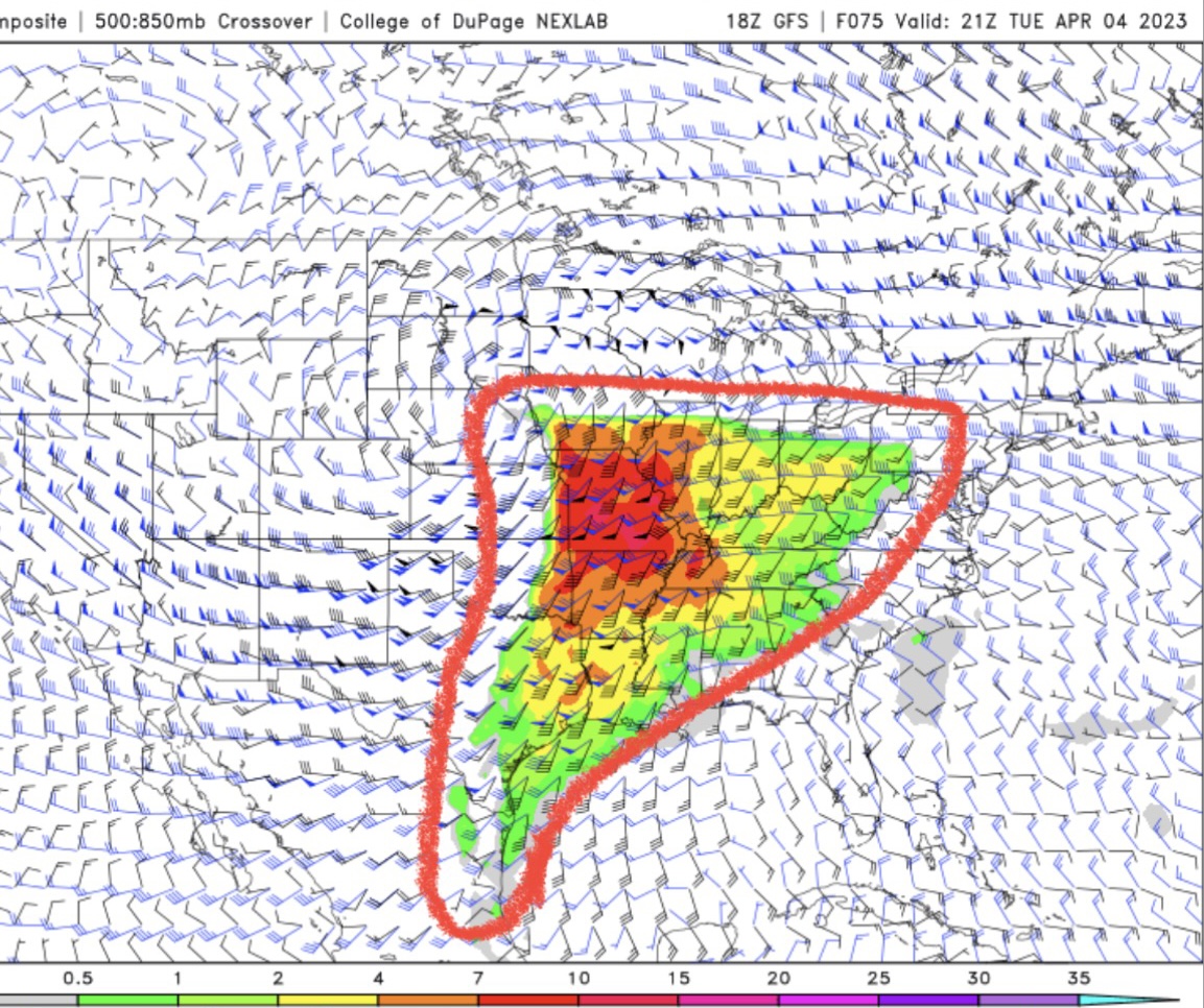
Looking at the GFS, these are high end Supercell Composite values being we are 80hrs out. The size of the warm sector is unreal.

-
2023 Mid-Atlantic Severe Wx Thread (General Discussion)
WxSynopsisDavid replied to Kmlwx's topic in Mid Atlantic
New Jersey -
The one good thing here is we have a few fail modes being presented. In all honesty, that is digging for something positive right now because the current fail modes still yield a sizeable outbreak.
-
Looking at the soundings, they are all high-end upper echelon type stuff. If you get past the small issues the NAM has been dealing with this year, those NAM soundings are still high end. As has already been discussed, the main issues here at this point remain: mixing, LCL's, early morning convection, capping inversion issues. Should those issues materialize, the floor would be yesterdays event. If we do not have any of those issues come Tuesday, this outbreak "COULD" rival the scope and magnitude of some of the bigger outbreaks we have seen. I know a lot of people on Twitter been throwing around 4/27 comparisons for size, and its very plausible the warm sector gets into southern Canada, its important to note for size/magnitude that can be debated. Everything else, no. Yesterdays event was close to some degree, a smaller "notch down" carbon copy of 4/3/74. Same areal coverage, same upper air support, but not quite on that level with violent tornadoes. I will say that I am more concerned for this upcoming outbreak than I was with yesterdays...and I still had concerns, not just as many as I have for this next one.
-
NAM suite is suggesting a strong cap in place in some areas that don't get breached until right before sunset. This would need to be monitored as it would suggest, if parameters hold, this would be a nocturnal event.
-
2023 Mid-Atlantic Severe Wx Thread (General Discussion)
WxSynopsisDavid replied to Kmlwx's topic in Mid Atlantic
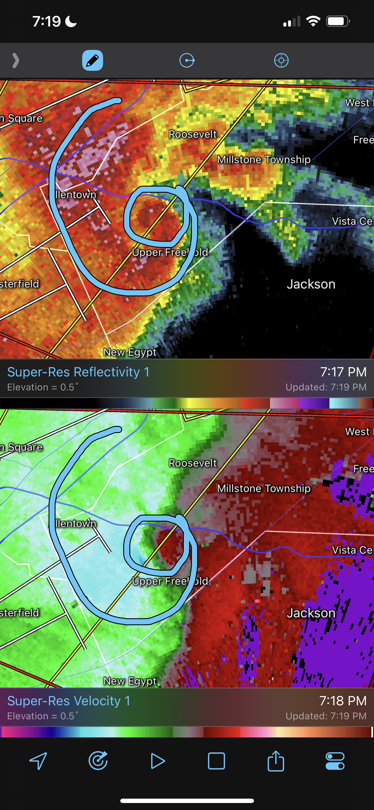
Absolute textbook of an embedded hook echo. Very rare to see this signature in the northeast.
-
There were similar trends at this range for the 3/2/2012 and 4/27/11. But you are right, this doesn't happen often and its rare.
-
Yes it did, it was probably the most accurate in terms of how it depicted the warm sector and the airmass recovery between the waves of discrete. Also, while other models were trying to congeal the stuff quicker to the south like in Arkansas, the RRFA kept everything discrete or semi-discrete. The helicity swaths it outputted yesterday morning was almost a carbon copy of what was experienced. The HRRR has also done great with these last 2 outbreaks too.
-
Important to note that the NAM suite was horrible with yesterday's outbreak and was also horrible leading up to the Rolling Fork incident. NAM suite has been getting out-performed this year.