WxSynopsisDavid
-
Posts
500 -
Joined
-
Last visited
Content Type
Profiles
Blogs
Forums
American Weather
Media Demo
Store
Gallery
Everything posted by WxSynopsisDavid
-
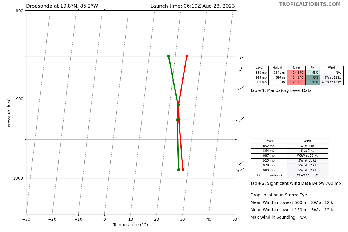
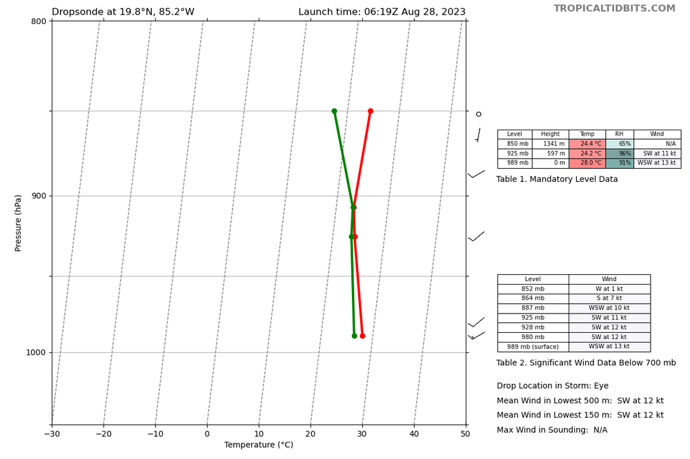
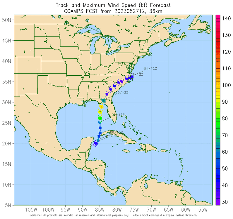
989mb
-
My suspicion is that there is some sort of internal process happening. Next 3-6hrs will be interesting.
-
Someone with more experience can correct me if my assumption is wrong, but if the vertical column stacks within the next 6-8hrs i believe the worse case scenario will unfold. Really hinges on how Idalia organizes/develops the core and if it continues to abate the shear and dry air
-
Not good, this falls in line with the hurricane models that have been on the higher-end of the intensity forecast.
-
Right at the end of the loop, you can see that the lightning activity starts to ramp up and circles around the core, noticeable ring like feature. I have only seen that with systems that are beginning an RI process or systems that have an RI underway.
-
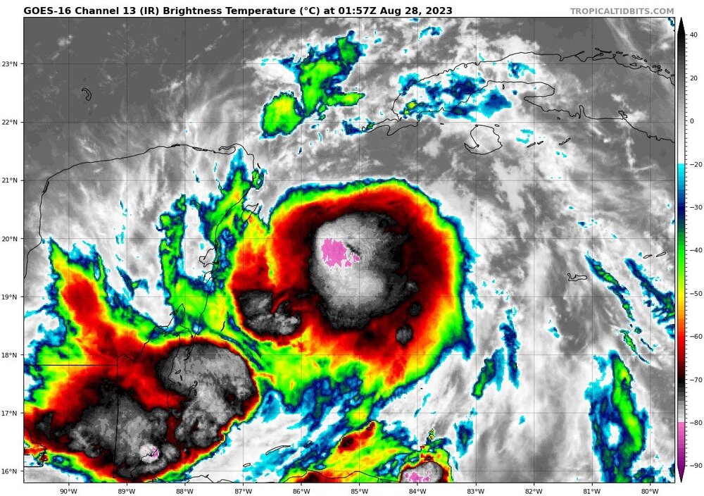
-
I agree, this is likely the beginning of an established inner core being developed. Very impressive to see this right now.
-
Really don't want this thing to take it's time moving ashore in those warm SST's. Not a great trend to have in this juncture. However...only real silver lining with a slower speed is it will increase the likelihood of an internal process such as an Eyewall Replacement Cycle being induced. Current forecast, showing Idalia moving ashore at a faster speed, does not support internal processes happening.
-
Disagree, Idalia does not even have an established CDO yet so what's happening tonight is not in relation to CCC. Idalia's issue is shear ATM. Once convection can stay consistent and shear/minimal dry air can abate, this thing takes off. Pretty much...the vertical column is not stacked yet and that is Idalia's hinderance in the short term.
-
-
That link is for TS Franklin, not TS Idalia.
-
When the circulation becomes vertically stacked you have a Category 1. So of course, circulation is not stacked as we don't have a category 1 yet.
-
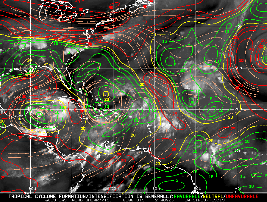
At the very least, I am more interested on the data they collect out ahead of the system across the Gulf. Curious to know if the models are right concerning the non-existence of dry air and the observations yielding decreasing shear.
-
Agreed, and it is not good that as forecasters we have no limiting factors in play here to discuss. It's come down to how long it lingers near the Yucatan....really feels like dejavu from some of the previous big gulf storms we have forecasted.
-
Looking at the shear values in the environment around TD 10, there's are a noticeable decrease in shear. Earlier today, the system was completely shrouded in 40kt shear. Now this evening, we see a big time decrease in shear to the northeast and some relaxation to the north. Not a good trend because this falls right in-line with those hurricane models earlier today. They seem to indicate the relaxation of shear this evening/overnight and better organization and development tomorrow.
-
Angle of approach is concerning, that would be a strengthening Category 3 approaching landfall. Frictional induced intensification through landfall.
-
Diurnal minimum is correct, this is typically when we see tropical systems lose that photogenic appearance. Big thing here is that during the day the centers of circulation are starting to organize. We are starting to see this system get a tad more symmetrical and some noticeable spin. What we ultimately are waiting for is the low, mid, and upper level circulations to stack. Once this thing starts to ventilate than we will have a better grasp on this system. Big thing everyone should be paying attention to is the environment out ahead of this system. With a lack of dry air and decreasing shear, it sets up a near pristine environment over 90+ degree SST's. There are some noticeable warm eddies in the Gulf too, not to mention how warm the Gulf Loop Current is right now. There are a lot of factors in play working for this thing to take off vs hindering it. With that said, recon data will be vital tomorrow. I'm curious to know if indeed we get an anticyclone development and I'm also curious to know if Recon Hunters find that shear and dry air are more significant than what models are showing.
-

2023 Short/Medium Range Severe Weather Discussion
WxSynopsisDavid replied to Chicago Storm's topic in Lakes/Ohio Valley
-
New couplet to the south, just south of banner
-
The 3k NAM rolling in right now is equally bad. Tries to pop rogue cells in Georgia while keeping everything else linear.
-
Something just appears off with these runs this morning. Mixing issues and capping issues are more prevalent right now. Concerning Wednesday, the HRRR has very little STP and parameters for the OH/TN Valley which seems odd.
-
Wednesday is really starting to look like a Major Severe Weather Outbreak. When the models started to slow the arrival of the front and short wave ejection, it was evident where we were going with this. The activity tomorrow, considering it initiates around or after sunset, will track east and lay down boundaries. Really be interesting to see if a cluster/MCS develops tomorrow night or early morning Wednesday. That tends to always happen the morning of a Major outbreak in the OH/TN Valleys and Great Lakes region.
-
Overall there’s very little discrete. The models that do have daytime convection tomorrow, it’s either linear or a multi-cell cluster. RAP, RRFS-A, HREF initiates discrete after sunset close to midnight. The tornado threat appears to be primarily nocturnal now. Early Wednesday morning into Wednesday afternoon.
-
Latest HRRR and RRFS-A showing morning convection going through the warm sector
-
Synoptically, this setup is different and not similar. This past outbreak actually had similarities and the analog was shown in the soundings. Just not seeing the similarities this time around.