WxSynopsisDavid
-
Posts
563 -
Joined
-
Last visited
Content Type
Profiles
Blogs
Forums
American Weather
Media Demo
Store
Gallery
Everything posted by WxSynopsisDavid
-
Dry air is not impacting the storm currently. The degrading appearance and egg shape Milton is taking on is a result of the N/NW shear beating down on the storm. Shear should relax later today in the afternoon.
-
Really comes down to the landfall point. Farther north it landfalls, the greater impacts it will sustain from shear and dry air. Farther south it landfalls, less impacts from shear and dry air. You do NOT want a landfall between Fort Myers and Naples. This would almost guarantee high-end Cat 4 or perhaps Cat 5 on landfall. Another thing to consider is how the hurricane models are starting to show a last minute rapid intensification on landfall. This would be both environmental and frictional induced but the critical angle of approach would also enhance the last minute RI process.
-
Ever since Milton began this ERC, the overall symmetry of Milton is drastically improving. Though it’s not annular, it’s definitely starting to gain similar characteristics.

-
Exactly what I’m thinking here. This ERC should be smooth and completes n time for Milton hitting the loop current. Milton’s actual peak likely to be achieved at that point.
-
Yes it can, pressure can easily drop into the 880’s now. Don’t think 190-200mph winds is out of the question because how healthy the CDO is and the fact the eye is only 2 to 4nm wide points to pressure continuing to tank. Until we see a double wind maxima which is the beginning of an ERC, Milton will continue to intensify.
-
The friction will tighten the core/eye up and help Milton to continue to intensify
-
Milton activating “Beast Mode”, we are likely very close to witnessing Milton’s true peak intensity being achieved.
-
Milton is the 6th
-
Milton is evolving into a buzzsaw right now

-
We will find out soon.
-
Not seeing a double wind maxima.
-
No, not a sign of ERC. Rather the opposite, sign that Milton is still bombing out and about to achieve its peak intensity.
-
It has, yes. Another solid indicator Milton is about to sustain very rapid and intense pressure falls. Likely only a few hours away from achieving peak intensity.
-
I agree as well, very plausible
-
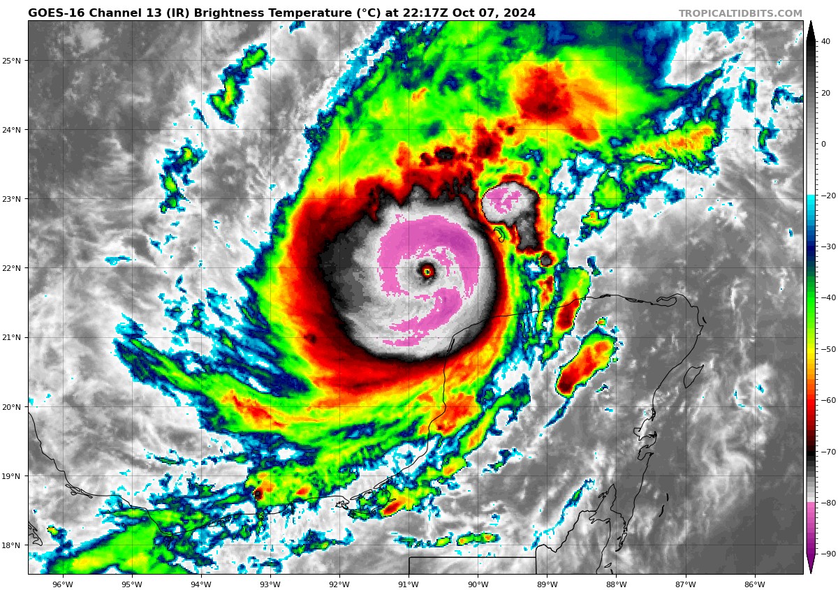
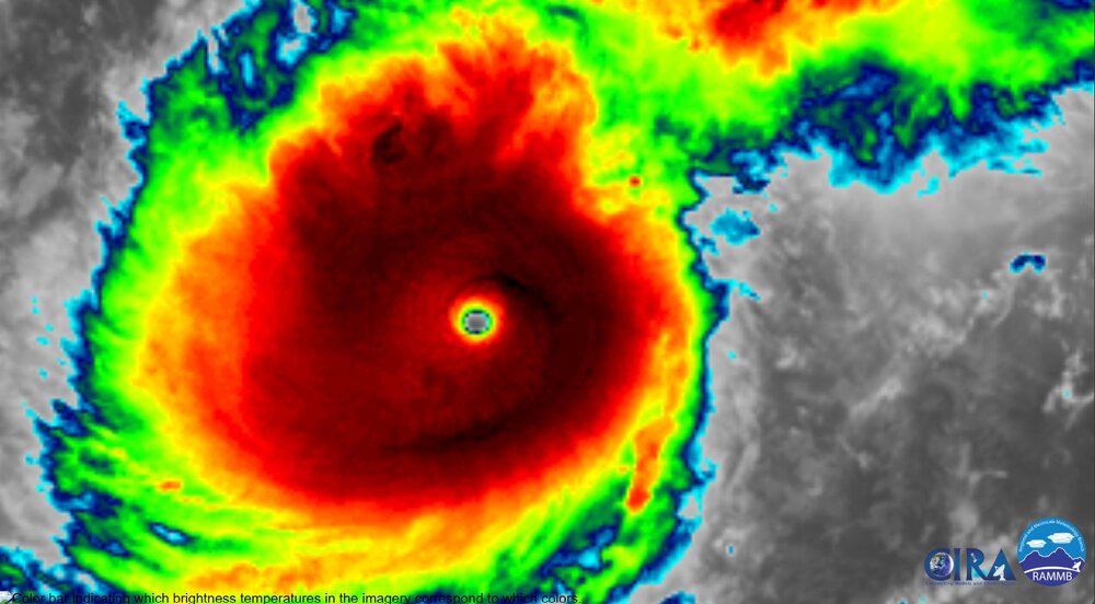
Perfect symmetry of CDO and overall as textbook as you can get with an ATL Basin hurricane.

-
This is not only historic but absolutely jaw-dropping what we are witnessing in the Atlantic Basin right now. Only a handful of times in the satellite era have we seen a hurricane achieve upper-echelon intensity. 5 times to be exact with Milton likely being the sixth. 2005 Wilma- 882mb 1988 Gilbert- 888mb 1935 Labor Day Hurricane - 892mb 2005 Rita- 895mb 1980 Allen- 899mb


-
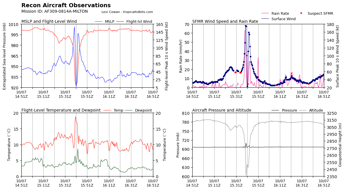
963mb is the landfall intensity on that run. That’s Cat 3, not Cat 1.
-
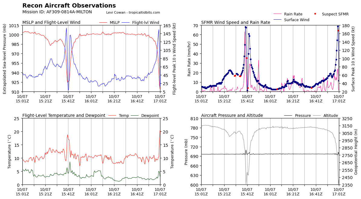
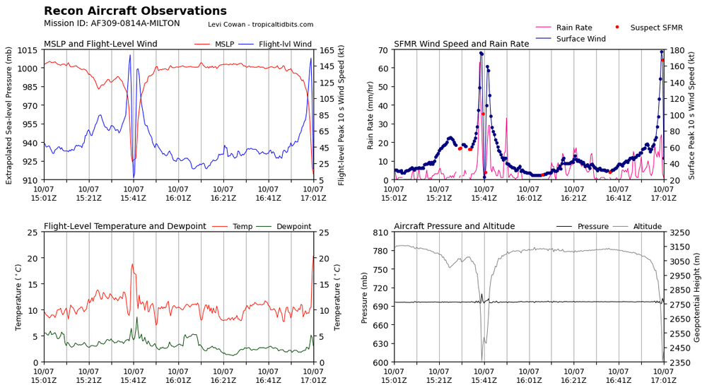
180kts (207mph) surface wind estimate, yeah we very rarely see that in the ATL Basin, even when it’s suspected SFMR
-
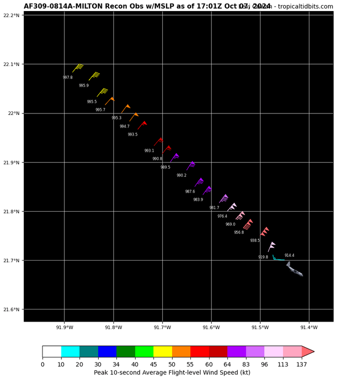
914mb extrapolated
-
Very impressive and historic

-
Category 5
-
I honestly can’t remember the last time ive seen a hurricane go from a TS to a buzzsaw with a pinhole eye in 12 hours. This has been not only an impressive intensification process to witness but one that is certainly historic.
-
GFS has the peak intensity Tuesday morning as Milton is just offshore of the Yucatan. Than as it turns NE, an ERC commences. Once it completes, Milton rapidly intensifies right before landfall and regains its lost intensity. Shear doesn’t get to it until right at landfall, very similar to what happened to Helene. This is becoming a common theme with Gulf hurricanes, particularly those landfalling Floridas west coast.
-
Only mitigates the wind threat. Really the focus should not be on intensity but rather surge and flooding. ERC will likely happen, and the storm will grow in diameter before landfall. Another factor is how slow Milton is moving now vs model predictions. Milton is moving slower which gives time to complete an ERC and regain lost intensity should shear and dry air be overdone at landfall. If it’s not, Milton rolls in at Cat 2/Cat 3 but brings that high-end surge and flooding threat.
-
Really, the debate of underperformance should be silent until we see the 00z model suite that gets ingest with the recon data being collected to the north. Either the data we seen today is spot on with shear and dry air or it overdone the limiting factors. Won’t know until that 00z data comes out.