WxSynopsisDavid
-
Posts
500 -
Joined
-
Last visited
Content Type
Profiles
Blogs
Forums
American Weather
Media Demo
Store
Gallery
Everything posted by WxSynopsisDavid
-
Double eyewall so it’s likely an EWRC or the one from yesterday that haven’t completed yet. These internal processes can take 24hrs or more to complete.
-
It does decent from my understanding. Outside of the hurricane models the EURO does better than the GFS with hybrid storms. Still there’s a lot of agreement among the models that a sub 930mb Fiona strikes Nova Scotia.
-
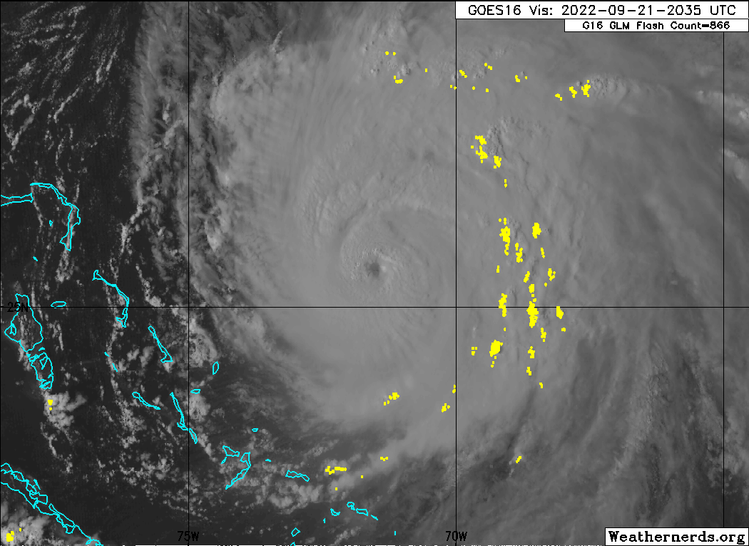
There’s also been mesovortices rotating throughout the eye of Fiona today so it could be another mesovortice that went up.
-
I am a gambling man, so I venture to say given the latest satellite presentations that pressure has dropped again but winds likely haven’t caught up. Either way it’s going to be interesting to see what they find
-
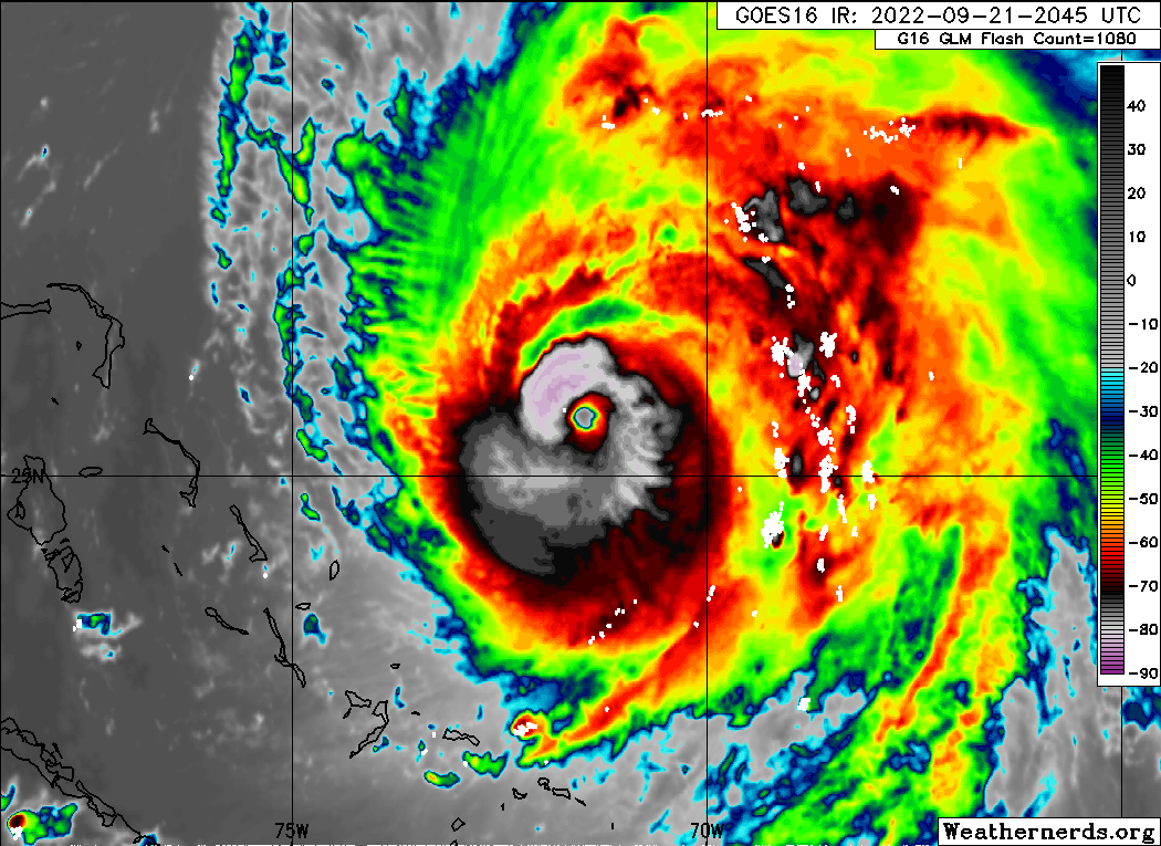
One thing I’m noticing is not only the reduction of the eye but how outflow is substantial now in all 4 quads. It’s noticeable on satellite that as Fiona gains latitude the shear abates the W and S quads. The rapid improvement overall in the last few frames is remarkable, as in how quick it’s happening. The small eye is leading me to think we get an RI process soon.
-
EWRC/internal processes still on-going but it looks like it’s about to complete. Cloud tops cooling again, ring of deep convection rapidly going up and wrapping around the eye. Eye is actually shrinking which is a classic sign we are about to get another RI process soon. Also, as Fiona is pulling away from the Islands shear is starting to abate and the W and S quads are starting to improve structurally


-
5am advisory is delayed to due an outage impacting NOAA. Very disappointing as they have made a ton of upgrades recently. Also, this is not an ideal time to have an outage.

-
8pm Advisory has winds now at 125mph and pressure down to 951mb. Fiona should be a Category 4 by the 11pm advisory
-
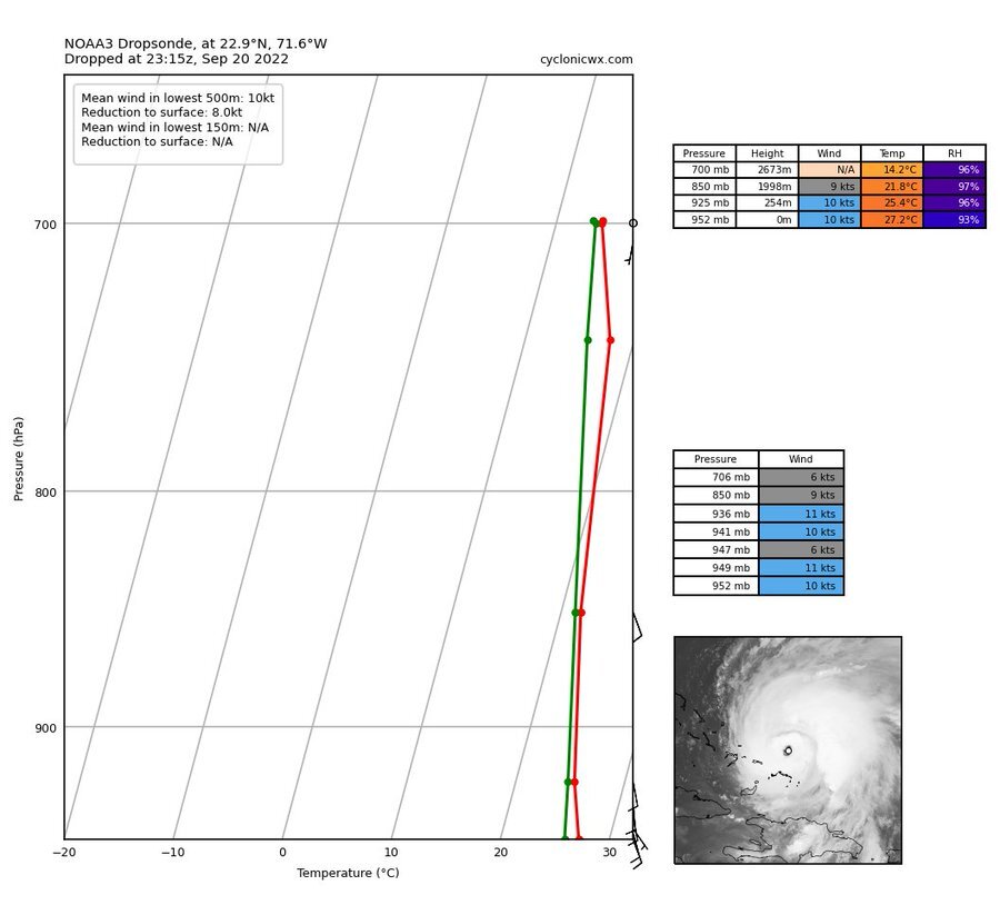
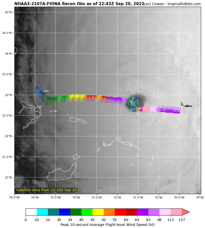
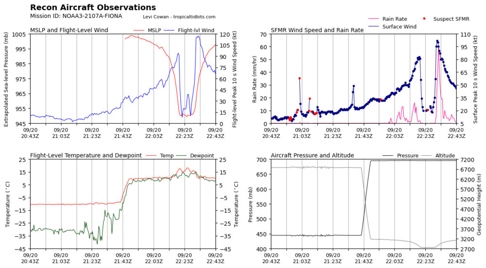
Fiona looks to be in the 120-125mph range. At 5pm we had 957mb. At 7pm we had 953mb and at 7:35 we have 951mb. Looks like rapid deepening is finally underway now.

-
"A wild, wacky, comedy adventure". That accurately describes Fiona lol
-
4mb drop since 11pm and its not even midnight yet. Appears the pressure has finally caught up to the winds. Bombs Away!!!!!
-
On paper....it looks like it has. Satellite appearance is appreciable, looks like the CDO is healthy. The vertical column looks shrouded and protected, don't see where there is any significant hinderance. No dry air entrainment and shear is very minimal. Outflow healthy in all 4 quads of the storm. The rapid cooling of the cloud tops, increased vortical towers going up along the eyewall, and mainly the presence of lightning in the eye tell me this thing is not only intensifying but about to start an RI process. It's a waiting game when recon finds that pressure has caught up. If they haven't found it yet I venture to say we are very close to that happening.
-
Very close, right on the cusp of being the first major cane of the year. Still looks like pressure is lagging behind though. Winds came up to 110mph but the pressure still at 972mb. This thing is about to bomb when the pressure catches up, by sunrise we should be seeing a rapid intensification phase underway.
-

General Severe Weather Discussion
WxSynopsisDavid replied to nwohweather's topic in Southeastern States
Overall I think this outlook is solid and has a decent chance of verifying -
General Severe Weather Discussion
WxSynopsisDavid replied to nwohweather's topic in Southeastern States
Concerning cloud cover, that’s not entirely true. Some of our biggest days (8/6/93 and 2/24/16) featured cloud cover extensively across the region during early half of the day. Regardless, this threat is driven by a warm front lifting to I64, surface low in OH, and a secondary surface low trying to develop back in western NC. Classic, textbook setup that has produced some of the regions biggest days for severe weather. Though I will say some soundings suggest zero capping inversion which could be a limiting factor as that would suggest a mixed/messy convective mode. -
General Severe Weather Discussion
WxSynopsisDavid replied to nwohweather's topic in Southeastern States
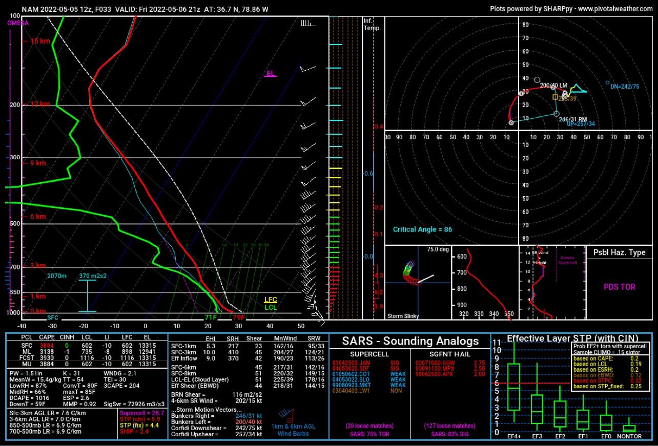
South Boston, VA from 12z NAM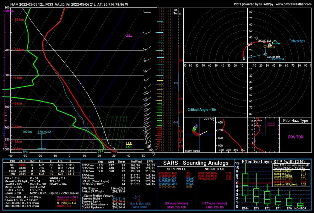
-
NWS reported cars flipped and tossed on Highway 67. That’s not hail damage. Unfortunately we are all farting in the wind since there’s no video evidence to support 4in hail and a large tornado. Daylight will reveal what indeed happened. But I suspect this was NOT straight line winds.
-
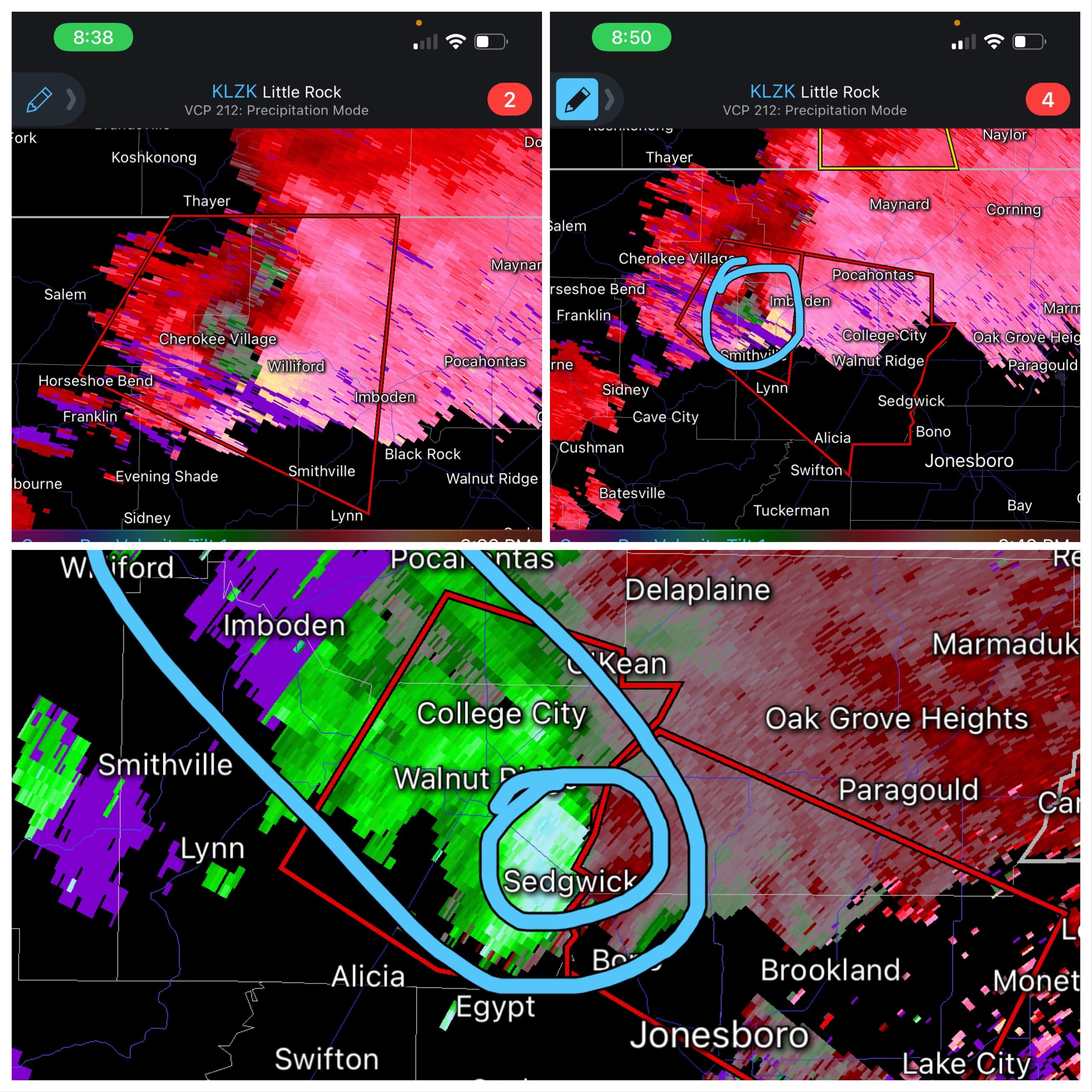
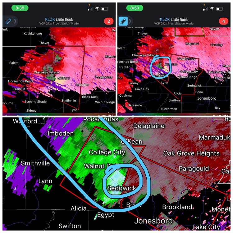
Radar situation did not make this situation any better. Happened between 3 radar sites and none of them showed this storm well. Another case in point. Bottom picture was a split from a dual pane with CC. I initially circled the large CC swath that the radar was showing. I was spotting errors with the CC that could of been caused by the 4in hail. That’s why there was 2 areas I circled.
-
Noticeable radar hole, hard to tell either way
-
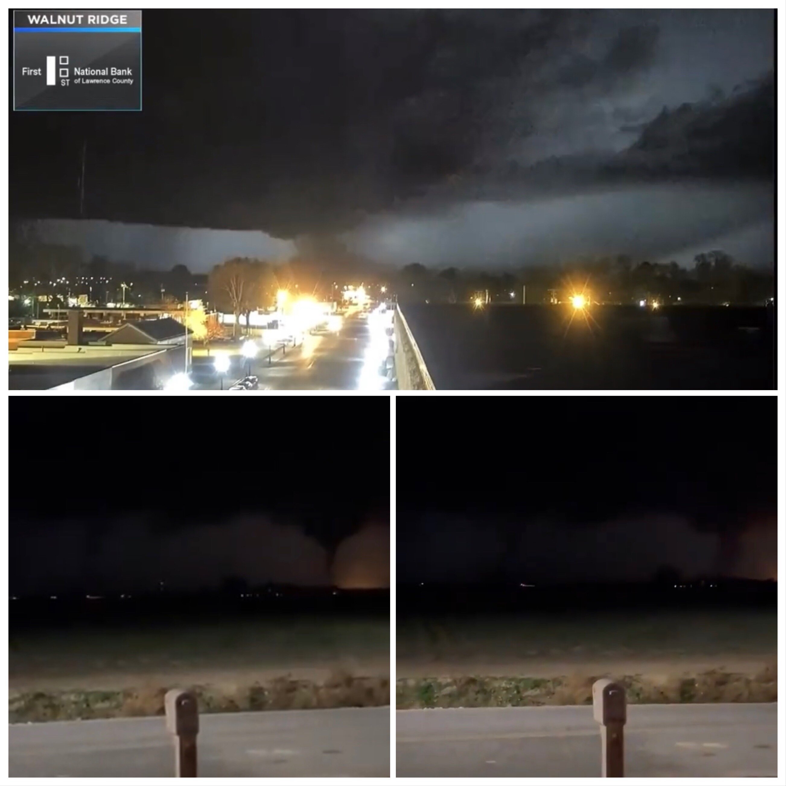
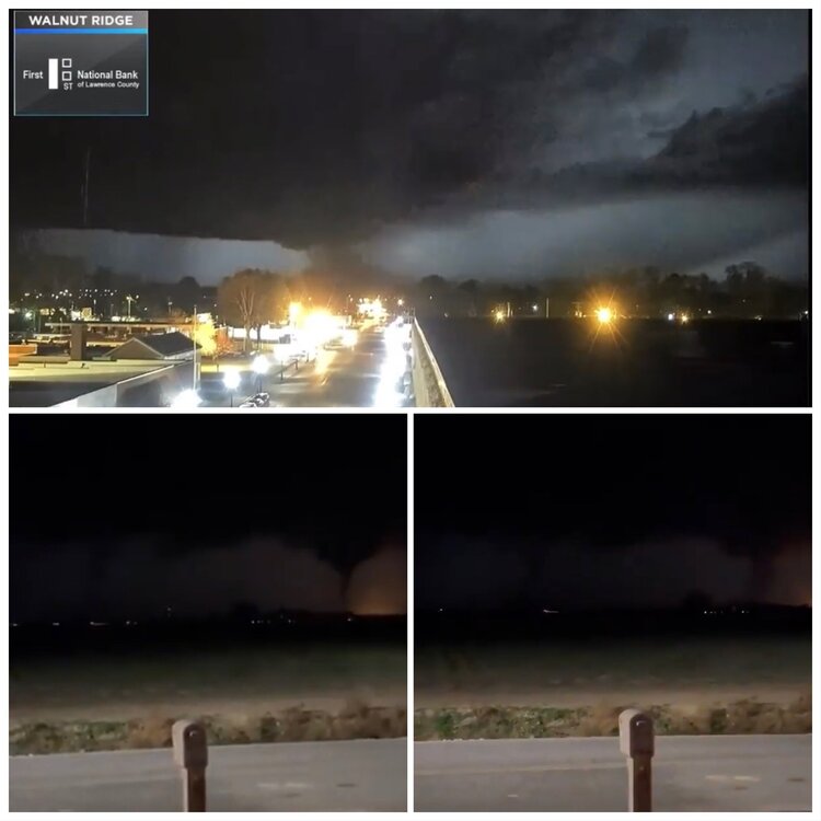
Looking at the traffic pattern in the area, roads are backing up for miles. Something indeed happened in swath from Rayenden, Imboden, College City. Likely a small tornado. Previous collage I posted on screen grabs are, again, a case study. Top picture was a shelf cloud reported as the large tornado. Bottom 2 pictures were screen grabs from a video going around Twitter that the media is sharing. That video is from December (thank you to MNstorms). Really think this situation needs to be assessed and reviewed by the NWS. Some serious changes need to happen going forward….inexcusable to throw a Tornado Energency for a scud bomb.
-
So I found a few videos on Twitter and was able to take screen grabs. There is indeed a tornado, it was on the ground, and damage is already being reported. A few of you missed the point that this was wrapped in hail up to and exceeding 4in diameter. This prevents challenges to using CC and looking for the classic CC drops. Also, the area this tornado occurred you can pull from numerous polling sites. You just don’t get a great view of the storm no matter which one you use. Now…..I don’t see a large tornado on the ground. So it’s obvious someone seen the shelf cloud and reported it as a large tornado. Other viewpoints showed it well and it was a rather small tornado. Really hope the NWS uses this as a case study to crack down on false reporting. Those people need to go back through skyward classes and need there spotter account revoked
-
In a high shear/low cape environment, you don’t get substantial surface based instability anyways. That’s why the environment is identified as a high shear/low cape environment. Cape is low, meaning that surface based instability is lacking
-
Disagree with temps. Your assumption applies to a high cape/low shear environment. You don’t need temps higher than the 60’s with high shear/low cape setups.
-
OBS/DISCO - The Historic James Blizzard of 2022
WxSynopsisDavid replied to TalcottWx's topic in New England
Did this thing bomb into the 960's yet or is it still 974mb? -
January 28-29 2022 Miller abcdefu Storm Obs/Discussion
WxSynopsisDavid replied to mappy's topic in Mid Atlantic
@Jebmanso I just need to know…is there a benchmark to define what justifies a jebwalk? And is there a max to the benchmark? Would a blizzard like 1996 be too extreme for a jebwalk or would these heart breakers lately not warrant a jeb walk? Just curious as I have been lurking on the page for awhile and see references to the jebwalk