WxSynopsisDavid
-
Posts
500 -
Joined
-
Last visited
Content Type
Profiles
Blogs
Forums
American Weather
Media Demo
Store
Gallery
Everything posted by WxSynopsisDavid
-
Fantastic? No it has not been fantastic. Matter of opinion I guess, but often after these storms we get stories they report and it an exaggeration of the truth due to the fact they don’t do their homework. There’s already been some things covered/reported on in the wake of Ian that is questionable.
-
Death Toll now stands at 87: 83 in Florida and 4 in North Carolina
-

Julia | 85 mph 982 mb peak | EPAC Crossover #2
WxSynopsisDavid replied to Iceresistance's topic in Tropical Headquarters
Across the northern Gulf, yes. But I wouldn't write the Gulf off yet. A path into southern FL or southern TX is still on the table if a system could stay across the southern Gulf. Also, we seen recently with Fiona and Ian that if these systems can RI and establish a deep core with convection upshear they can become resilient to not only shear but mix out dry air from the CDO. A lot of uncertainties remain and its way too early to say for sure what's going to happen. Let's hope the 18z GFS is right -
Julia | 85 mph 982 mb peak | EPAC Crossover #2
WxSynopsisDavid replied to Iceresistance's topic in Tropical Headquarters
Let's hope your theory is right because SST's in the Gulf are still 85+ and there is still a pocket of high Ocean Heat Content -
Julia | 85 mph 982 mb peak | EPAC Crossover #2
WxSynopsisDavid replied to Iceresistance's topic in Tropical Headquarters
Deja vu all over again, this early track consensus reminds me of the early days of Ian. Though this system should track more to the north and not into South America, its very interesting to say the least -
I remember with Katrina the media paid little mind to MS/AL coastline ahead of Katrina. When we started to see the devastation, of course the media started changing their tone. Just similar mistakes being made here, media only out for the hype/ratings and hone in on major cities without covering all the areas to be impacted.
-
And just like Katrina, outside of politics and politicians, the media is at fault here with Ian.
-
And here presents another difficulty no matter what we use: saffir simpson, IKE, severity index, etc. The media is problem #1 here. They misunderstand how hurricanes are rated by the SS and often times only focus on gusts without explaining sustained winds and how they are dangerous. Another issue are all these media outlets incorporating their own rating scales (low, medium, high/minor, moderate, extreme). Often they will create their own tracks/paths for these storms and it either conflicts with what the NHC has and/or they overlay their forecast on top of NHC's cone. The media also does a poor job concerning the cone NHC uses because they don't use it properly and explain to their audience what the cone actually is. Impacts are felt outside the cone and the media makes it seem its the opposite.
-
Seen a new estimate today, $63 billion for Florida. Again that’s mostly for damage caused in SW FL and not the flooding damage through central and eastern sections of the state. I’m curious as to the total cost Ian will have inflicted overall. 2 US landfalls with extensive flooding which should put him in the Top-3 for US hurricanes. And there’s Cuba and we still don’t know a lot about his impacts down there yet. Ian has a shot at being one of the costliest Atlantic hurricanes.
-
Fairly certain there’s been questions with Michael too. I remember when Tim Marshall surveyed the damage after Michael he noted he couldn’t find proof winds ever exceeded 140mph. His survey didn’t yield any definitive proof either and that was because as he noted a lot of the structures in the panhandle are pre-1995 and were constructed poorly. With Ian, he caused catastrophic damage to an area that has modern building codes and an area that was rebuilt after Charley. We will see what his survey says and what NOAA decides to do in the months to come. In the end NOAA went against the survey and still rated Michael a Cat 5. Also we are still not seeing the whole picture with Ian and it’s still in the early stages of the aftermath.
-
I sincerely hope the media is exaggerating that story or they reported BS and didn’t do their homework like always
-
How could this be used to get the general public to understand it?
-
I do like that scale they have and adopting a similar scale might help the general public understand hurricanes better. However, the scale still focuses on winds. This still doesn’t solve the issue with Sandy, Fiona, Ike. Sandy and Fiona were both hybrids. Fiona struck Nova Scotia with 931mb of pressure but winds were only 100 mph (Cat 2) and Sandy struck the northeast with 940mb but only had 80mph winds (Cat 1). We need a scale that also handles these hybrid hurricane situations properly…..and storms like Ike that were a Cat 2 but generated Cat 4/Cat 5 surge at landfall.
-
I will have to read up on the severity index. The return period study is also interesting so I’ll have to delve into that more. Now concerning the GA/SC coastline, yeah they are overdue and been overdue for a long time. Let’s not forget how close they came with Florence, when in the early stages of that storm the Euro was showing a Savannah, GA landfall as a Cat 4. Than it shifted to a SC landfall before eventually locking on a Wilmington, NC landfall. Not just GA/SC but NC is overdue as well.
-
The downside to using pressure is Sandy and Fiona type events. They had pressure of Cat 4’s but struck at much lower intensity concerning winds. I do like where this conservation is going because it’s obvious the Safir Simpson scale is outdated. It doesn’t do a good job with these Sandy, Fiona, Ike, Katrina, Ian type storms.
-
Michael didn’t achieve Cat 5 until the review process and the TCR was composed. Andrew didn’t achieve Cat 5 until the reanalysis in 2004. When these storms landfall there’s a whole set of data they have that we don’t have access to that they flag for review purposes. We see only what they want us to see if the recon data. So in saying that, we will wait and see what their review shows of Ian. Keep in mind damage might not look that bad and understand a lot of that area was rebuilt after Charley. Michael rolled through an area that had poor building codes.
-
That’s very impressive, Irma for comparison was 125 TJ
-
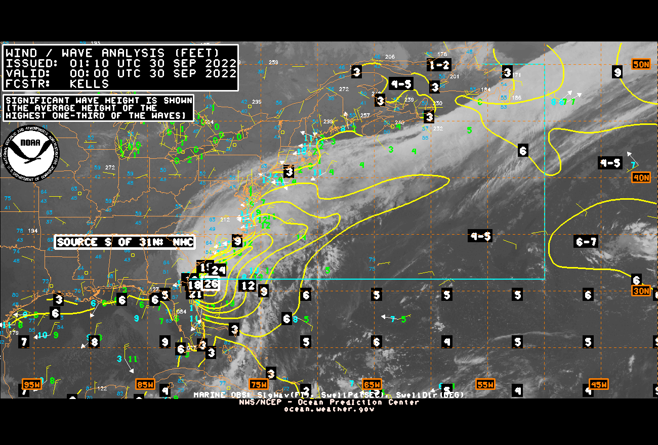
Those wave heights are fairly significant and increasing gradually

-
Well…..there’s a likely 20 that can be added to the death toll

-
Yeah…..we aren’t seeing the worst of it. This is going to be like some of the high-end canes in the past. Whereas we don’t see the worst until like the Day 3 range when they start to get to those areas.
-
Here we go with this BS we endured after Katrina. The ignorance of some people…idk why I even try. What’s said is I even scrolled through Twitter and saw post from local Mets down there saying “we had little time to prepare” or “this was only suppose to be a weak hurricane”
-
Hurricane Michael had ridiculous storm surge around Mexico Beach, so for me, that’s the recent storm that comes to mind.
-
Unfortunately we never know the true extent of the wind damage until after the fact
-
It contracted earlier between 2am and 4am before this RI process
-
Really doesn’t matter now, damage has been done. Whether it stays 155mph or weakens to 130mph, or perhaps 110mph, the surge event is going to be catastrophic. Too late in my opinion