WxSynopsisDavid
-
Posts
511 -
Joined
-
Last visited
Content Type
Profiles
Blogs
Forums
American Weather
Media Demo
Store
Gallery
Everything posted by WxSynopsisDavid
-

March 14-15 Severe Weather Outbreak
WxSynopsisDavid replied to HillsdaleMIWeather's topic in Lakes/Ohio Valley
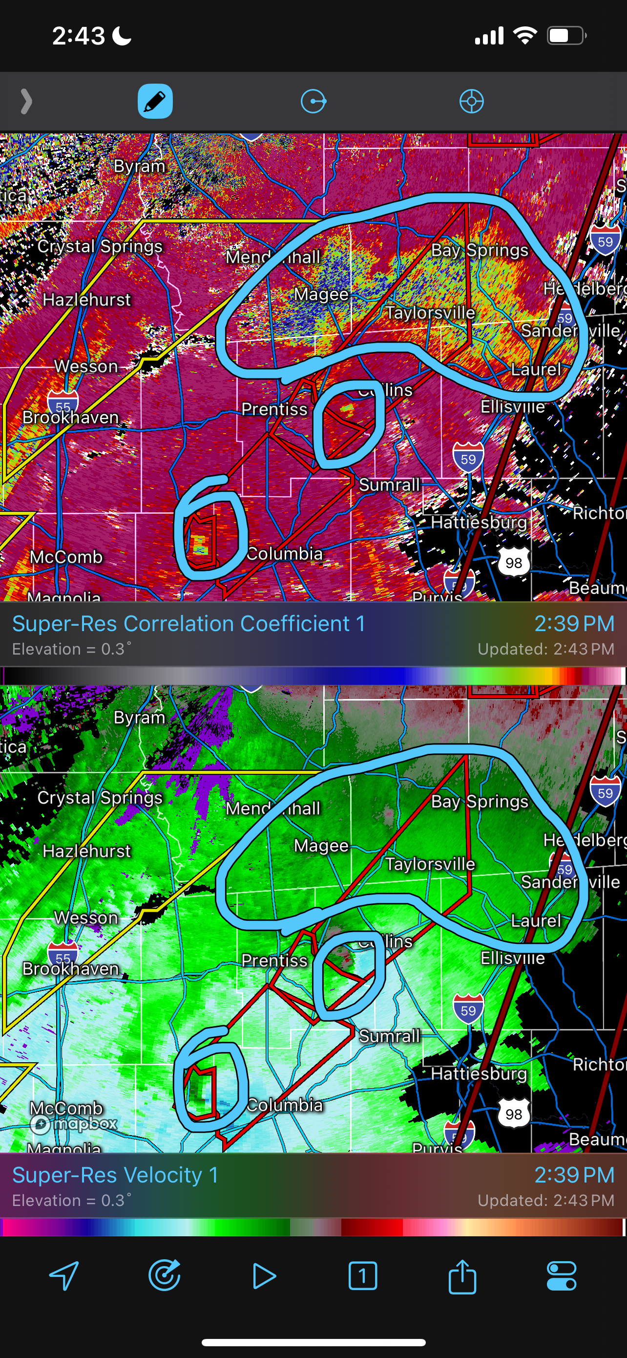
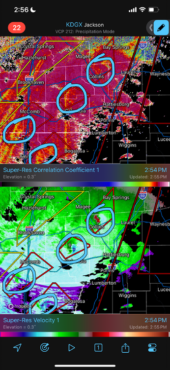
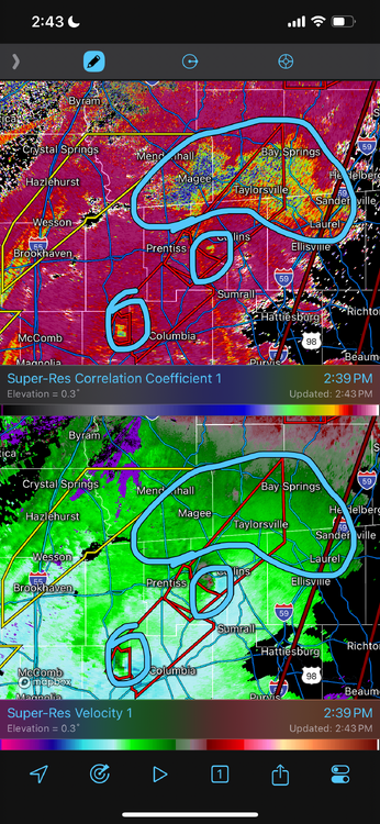
From roughly Tylertown up through Bay Springs, 5 tornadoes went through that area. Haven’t seen that since the 3/2/12 outbreak. I remember there was an area in either Kentucky or WVA for the 3/2/12 outbreak that had 6 tornadoes train the same corridor. It’s certainly something that doesn’t happen often and typically is seen in these high-end outbreaks. -
This is getting ridiculous. Areas from Tylertown to Bassfield about to be worked over by a 3rd violent tornado. Another one will be tracking to the east. 4 violent tornadoes ongoing simultaneously now.
-
Unreal and catastrophic situation for areas from Tylertown to Bassfield. Two likely EF4+ tornadoes training over the same areas. The lead tornado has produced an exceptionally large debris fallout that has been ongoing on radar for awhile now.
-
The disconnect was in relation to the potential fail modes and timing issues. Those have resolved with today’s guidance so far. Reason why NWS SPC and the local NWS offices adjusted accordingly. I can say that if 18z data holds course, most of us on this thread will begin to get an idea of what tomorrow will compare to.
-
NWS Birmingham
-
Disagree, because there were a few of us that knew 1 day out that 4/27/11 was going to be the next Super Outbreak. Evidence of that can even be found here if you go back far enough in the threads. The fail modes we have with this weekends event and the moisture issues we have seen on the models, we didn’t have 1 day out for 4/27/11. Most of us were discussing what impact that morning MCS was going to have: would it cap the outbreak to a Regional Tornado Outbreak or create a Conus-Wide Super Outbreak? There are certain anomalous signals that when they present themselves you know if the outbreak is going to become a Super Outbreak. Research 4/3/74 and 4/27/11. And for clarification, the day before 4/27/11, I did not imagine the event producing 200+ tornadoes in that 24hr period. My expectation was total count to be similar to 4/3/74.
-
To me, it’s a tick away from being a Super Outbreak. Moisture uncertainties are for me the biggest uncertainty. However, another uncertainty for me is just how this open warm sector will evolve tomorrow. In recent years we have seen these open warm sectors/loaded gun environments fail because of morning convection. Important to note, 4/27/11 had morning convection but it did nothing to temper the environment. It’s also not a great sign that the closer we get to tomorrow, the more nastier the model guidance is getting.
-
Not a fan of the sarcasm for an outbreak scenario that is going to be devastating for some. Maybe in the future such banter should be directed to the banter thread.
-
FV3, HRRR, RGEM all look very similar. NAM is very notorious being cold in WAA regimes at this range. Usually under 48hrs, NAM starts to trend towards the other CAM solutions.
-
To key off your remarks, whenever the data presents it self in the future, we will know for certain when an outbreak is going to go Super Outbreak. They have a classic, textbook anomalous appearance with every facet of model data we use to measure the environment. At this range, there’s typically no limiting factors. With this weekends outbreak, there are a ton of fail modes possible. Not to mention quite a few scenarios involving timing issues. Moisture return is one of the greater uncertainties right now.
-
It doesn’t compare to 2011.
-
Dr Knabb been explaining on TWC today that surge effects will actually peak well after landfall. Forecast is for surge to peak around high-tide as the winds shift back around from the west.
-
WFLA News Channel 8 is live streaming on Facebook. The on-air Mets disagree and said Milton is coming right into the mouth of the Bay. Just told people Tampa will be taking a direct hit.
-
It’s getting close, yes. Probably about 1-2hrs away from that happening.
-
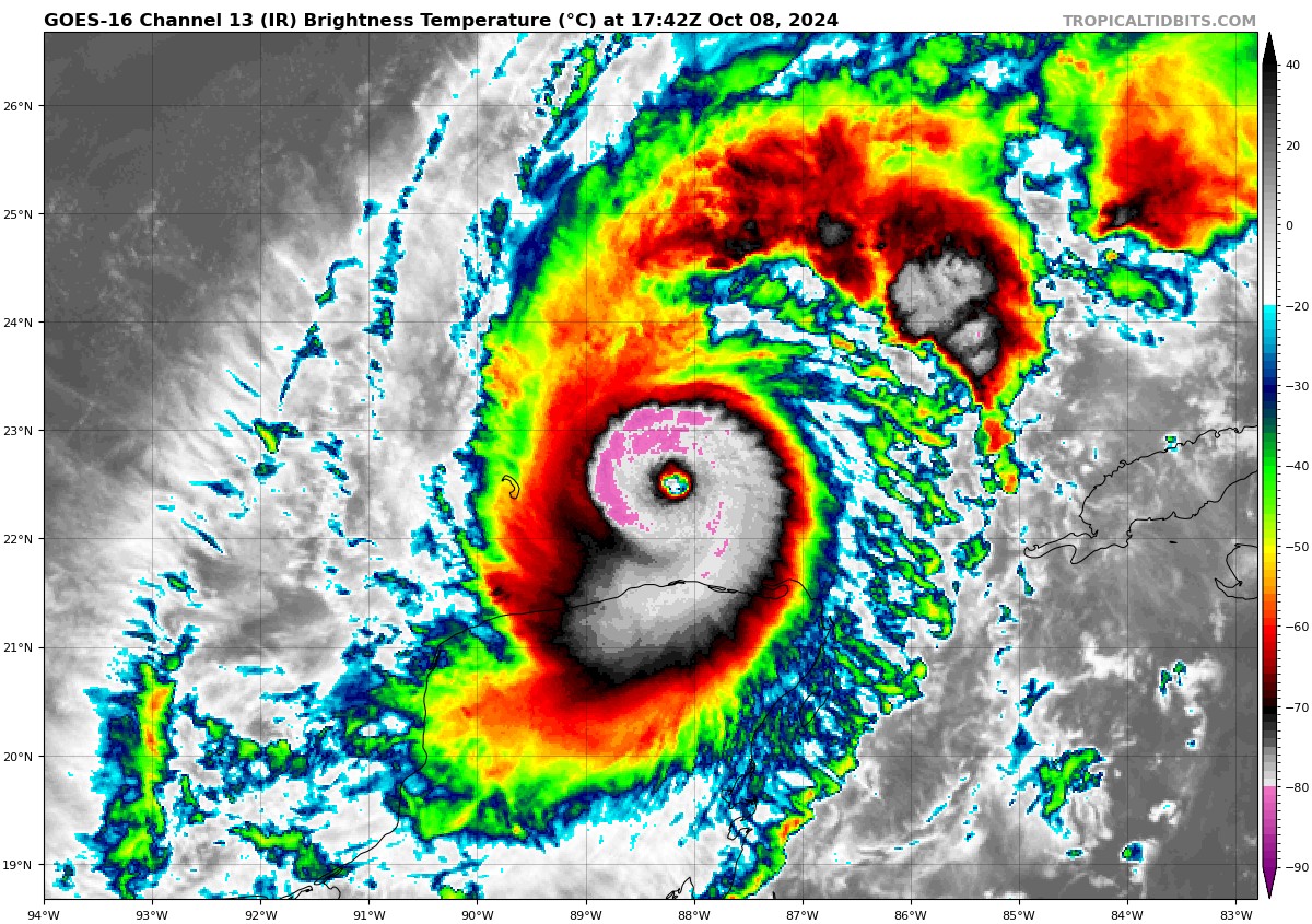
Not quite, the symmetry is not there. Milton is lopsided and ragged. Not to mention the eye is still not quite organized and open yet.
-
Post less, read more. Before asking a question, scroll back and see if it’s already been asked, answered, or perhaps to see if someone else inadvertently answered your question.
-
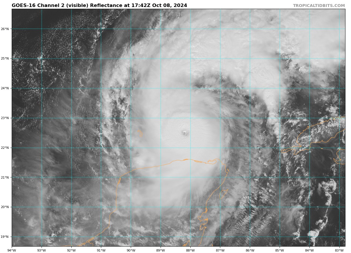
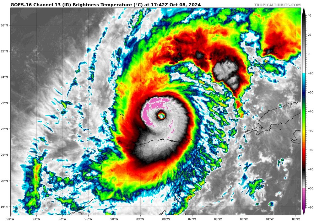
Yet again, Milton is rebounding very healthy from an ERC. Continues to remain resilient to shear and dry air. Absolutely not what you want to see heading into landfall. Milton was expected to have its bottom ripped out from this ERC and roll in as a weak Cat 3. Milton is simply holding its intensity and that strong inner core. Really poses a serious threat to over-performing in terms of landfall intensity. That’s if Milton continues to remain resilient, Milton will most certainly have one final intensification process as it nears land. Would be both environmental and frictional induced. Overall, I’m not liking this trend we are seeing and starting to grow concerned of the aspect of greater intensity on landfall. Hopefully, post ERC, Milton loses the resiliency.
-
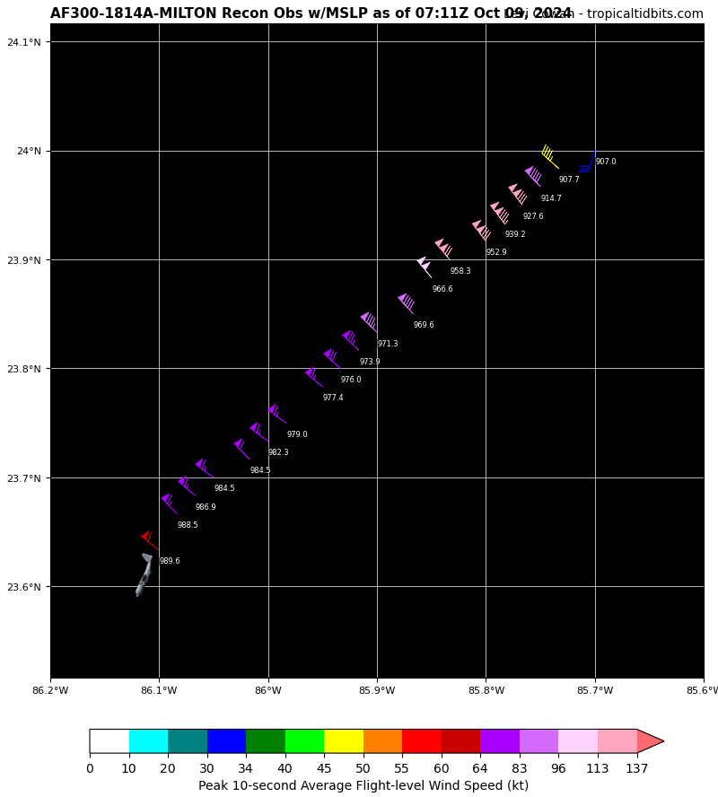
This would make Milton the first ATL Basin hurricane to go Sub-910 three times.
-

-
907mb
-
Yeah, Milton’s core is still very small and compact. Finding Milton’s peak wind is no easy task. They can easily miss it.
-
Is that correct, NW eyewall? That’s an impressive reading in the NW quad if that’s correct. Since winds are much more intense in NE quad, that would make me believe winds are around 180-185.
-
This is a remarkable Post-ERC recovery. Milton should begin undergoing intense, rapid pressure falls once again within the next few hours.

-
Milton is beginning another Rapid Intensification process. Should shear continue to relax, this will be Milton’s last chance at making a run at peak intensity. Milton starting to move over a warm eddie. Should be over this warm eddie for the next several hours. Later today into the evening and overnight, Milton will be over the Gulf Loop Current.
-
That’s also the NW Eyewall where the weaker winds tend to be. Will be interesting to see what the NE Eyewall yields.