

TheClimateChanger
-
Posts
4,598 -
Joined
-
Last visited
Content Type
Profiles
Blogs
Forums
American Weather
Media Demo
Store
Gallery
Everything posted by TheClimateChanger
-
Central PA Autumn 2024
TheClimateChanger replied to Itstrainingtime's topic in Upstate New York/Pennsylvania
Sorry misread that. The record broke in February.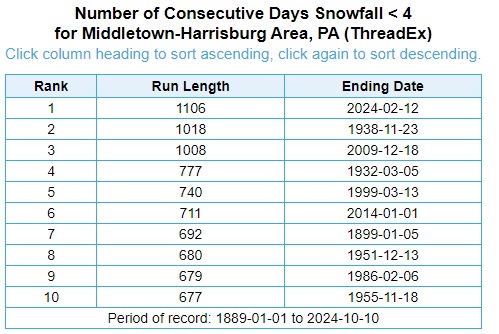
-
Central PA Autumn 2024
TheClimateChanger replied to Itstrainingtime's topic in Upstate New York/Pennsylvania
It's been a record-breaking 1,106 days since the last 4" calendar day snow at Harrisburg.
-
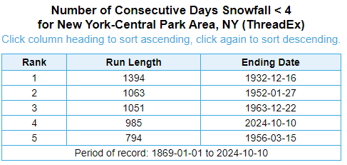
Will NYC break the record for longest streak without a calendar day snowfall of 4 or more inches? If it doesn't happen on or before the end of December, the streak will move into second place [still 82 days left in the year]. If it doesn't happen this winter, highly likely to break the record [unless there was a very early snowstorm in winter 2024-25].
-
Pittsburgh, PA Fall 2024 Thread
TheClimateChanger replied to TheClimateChanger's topic in Upstate New York/Pennsylvania
Will this be the year we see a 4"+ daily snowfall? Or will we break records for longest snowfall drought? It's currently been 943 days since the last 4"+ snowfall in a single calendar day. If we fail to reach that this winter, we will very likely reach a record streak.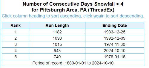
-
I know Hawaii - especially Honolulu and Kahului - had a lot of record highs in 2019. Kahului had 20 of 23 days with record highs [some have since fallen]. You'd think something like this - if it were to occur - would be in a place with very low variation, where globally warmed ocean surface temperatures could push the highs up 2-3F to record levels day after day. Places like Hawaii or Key West. You wouldn't expect it in the continental interior, where there's tons of variability. And I know it's a little less in Arizona, but still... no late season monsoonal push of moisture to disrupt the trend, no push of modified Pacific air, no cold front from the interior. And it's more impressive from a departure standpoint. In a maritime climate, those record highs might only be 5F above the normal high temperatures. Phoenix has had day after day of 15F+ departures from normals that have already risen substantially from prior decades.
-
Central PA Autumn 2024
TheClimateChanger replied to Itstrainingtime's topic in Upstate New York/Pennsylvania
Backwards? How does that work? -
Pittsburgh, PA Fall 2024 Thread
TheClimateChanger replied to TheClimateChanger's topic in Upstate New York/Pennsylvania
The NWS has upgraded all of southwest Pennsylvania, except for Allegheny and Beaver Counties, to a freeze warning. Definitely protect or bring in any sensitive vegetation. -
-
In fact, the current forecast has record high temperatures continuing through Columbus Day, which would bring the streak up to 21 consecutive record-breaking or record-tying high temperatures. Three consecutive weeks of record highs. Insane.
-
The record-breaking heat wave at Phoenix has now reached 16 days. Record for today is 105F, and the current forecast for PHX airport is 106F. So decent odds we add a 17th consecutive record high today.
-
Pittsburgh, PA Fall 2024 Thread
TheClimateChanger replied to TheClimateChanger's topic in Upstate New York/Pennsylvania
Going to be unseasonably cold, but I don't know if I'd go so far as to say "frigid." Record low max temperatures for this time of the year are generally in the upper 30s to lower 40s. Doubt we see anything that cold. -
Pittsburgh, PA Fall 2024 Thread
TheClimateChanger replied to TheClimateChanger's topic in Upstate New York/Pennsylvania
Wouldn't be a true Indian summer if it didn't come after the first frost/freeze of the autumn. -
Mountain West Discussion
TheClimateChanger replied to mayjawintastawm's topic in Central/Western States
15 consecutive record highs at Phoenix and counting. -
Also, I don't believe for a minute the temperatures reported for Burlington, Iowa in 1936. It was hot, but it's clear there was a massive warm bias at wherever the records were taken. As an apparent co-op site, it likely also suffered from a TOBs bias. Compare it to Moline. At the current sites, it averages about 1F cooler in the month of July. But in July 1936, it was more than 3F warmer. Moline Burlington


-
Per ThreadEx, 63 of 365 days in 2023 saw high temperatures among the three warmest of record, and 60 of 365 days in 2023 saw low temperatures among the three warmest of record. 2024 data is not available, but it probably is even crazier.
-
Pittsburgh, PA Fall 2024 Thread
TheClimateChanger replied to TheClimateChanger's topic in Upstate New York/Pennsylvania
I was surprised by all the frost this morning, given the forecast was calling for low 40s. Even saw some ice on the road. Hoping it didn't take out my tender vegetation. -
Arctic Sea Ice Extent, Area, and Volume
TheClimateChanger replied to ORH_wxman's topic in Climate Change
Ok, sure. @tacoman25 or whatever he used to call himself. The deceased @nzucker. Even some very respected "moderate voices" never said that. Sure, I'm making it all up. -
Pittsburgh, PA Fall 2024 Thread
TheClimateChanger replied to TheClimateChanger's topic in Upstate New York/Pennsylvania
Looking good for some Indian summer action in the second half of October. Are we still allowed to use that terminology? -
Occasional Thoughts on Climate Change
TheClimateChanger replied to donsutherland1's topic in Climate Change
Very impressive to see this many record-breaking warm years. -
Occasional Thoughts on Climate Change
TheClimateChanger replied to donsutherland1's topic in Climate Change
302198 Dunkirk Pwr Plt Dunkirk--Fredonia NY 42.4932 -79.27623 1-Jan-24 6-Oct-24 280_DAY Year to Date 27 57.3 6.1 1st warmest 96 322859 Fargo Hector Intl Ap Fargo ND 46.92424 -96.81186 1-Jan-24 6-Oct-24 280_DAY Year to Date 83 52.1 5.6 1st warmest 99 FARthr Fargo Area Fargo ND 46.92424 -96.81186 1-Jan-24 6-Oct-24 280_DAY Year to Date 144 52.1 5.6 1st warmest 99 202102 Detroit City Ap Detroit MI 42.40725 -83.00899 1-Jan-24 6-Oct-24 280_DAY Year to Date 90 58.9 5.3 1st warmest 99 308383 Syracuse Hancock Ap Syracuse NY 43.1111 -76.10384 1-Jan-24 6-Oct-24 280_DAY Year to Date 86 56.5 5.2 1st warmest 99 SYRthr Syracuse Area Syracuse NY 43.1111 -76.10384 1-Jan-24 6-Oct-24 280_DAY Year to Date 122 56.5 5.2 1st warmest 99 362260 Dubois Faa Ap DuBois PA 41.17947 -78.89326 1-Jan-24 6-Oct-24 280_DAY Year to Date 56 55.7 5.1 1st warmest 98 208941 White Lake 4e MI 42.69806 -83.47167 1-Jan-24 6-Oct-24 280_DAY Year to Date 24 53.6 5 1st warmest 96 426424 Ogden Caa Ap Ogden UT 41.19406 -112.01682 1-Jan-24 6-Oct-24 280_DAY Year to Date 28 60.7 5 1st warmest 96 201213 Houghton Faa Ap Hancock MI 47.16594 -88.48076 1-Jan-24 6-Oct-24 280_DAY Year to Date 136 48.6 5 1st warmest 99 203908 Houghton Faa Ap Hancock MI 47.16594 -88.48076 1-Jan-24 6-Oct-24 280_DAY Year to Date 136 48.6 5 1st warmest 99 206438 Pellston Rgnl Ap Pellston MI 45.5644 -84.79291 1-Jan-24 6-Oct-24 280_DAY Year to Date 77 50 4.8 1st warmest 99 301979 Dansville Ap Dansville NY 42.56985 -77.71426 1-Jan-24 6-Oct-24 280_DAY Year to Date 28 56.9 4.7 1st warmest 96 193276 Groveland Boston MA 42.7467 -71.0426 1-Jan-24 6-Oct-24 280_DAY Year to Date 32 56.8 4.7 1st warmest 97 366992 Pittsburgh Allegheny Ap Pittsburgh PA 40.3551 -79.92145 1-Jan-24 6-Oct-24 280_DAY Year to Date 41 60 4.7 1st warmest 98 360865 Bradford Rgnl Ap Bradford PA 41.79835 -78.63543 1-Jan-24 6-Oct-24 280_DAY Year to Date 63 53.3 4.7 1st warmest 98 366993 Pittsburgh Asos Pittsburgh PA 40.48459 -80.21448 1-Jan-24 6-Oct-24 280_DAY Year to Date 77 59.6 4.7 1st warmest 99 PITthr Pittsburgh Area Pittsburgh PA 40.48459 -80.21448 1-Jan-24 6-Oct-24 280_DAY Year to Date 149 59.6 4.7 1st warmest 99 469487 Wheeling Ohio Co Caa A Wheeling WV 40.16994 -80.64406 1-Jan-24 6-Oct-24 280_DAY Year to Date 29 59.8 4.6 1st warmest 97 435278 Montpelier Ap Barre VT 44.20503 -72.56545 1-Jan-24 6-Oct-24 280_DAY Year to Date 74 50.2 4.6 1st warmest 99 302615 Elmira Faa Ap Elmira NY 42.15658 -76.90291 1-Jan-24 6-Oct-24 280_DAY Year to Date 37 55.4 4.5 1st warmest 97 301012 Buffalo Niagara Intl Buffalo NY 42.93998 -78.73606 1-Jan-24 6-Oct-24 280_DAY Year to Date 86 56 4.5 1st warmest 99 BUFthr Buffalo Area Buffalo NY 42.93998 -78.73606 1-Jan-24 6-Oct-24 280_DAY Year to Date 150 56 4.5 1st warmest 99 200711 BENTON HARBOR AIRPORT ASOS MI 42.12894 -86.41518 1-Jan-24 6-Oct-24 280_DAY Year to Date 28 56.8 4.3 1st warmest 96 065273 New Haven Wb Ap New Haven CT 41.26667 -72.88333 1-Jan-24 6-Oct-24 280_DAY Year to Date 49 58.9 4.3 1st warmest 98 208251 Traverse City Faa Ap Traverse City MI 44.73895 -85.5679 1-Jan-24 6-Oct-24 280_DAY Year to Date 127 54 4.3 1st warmest 99 207366 Sault Ste Marie Sndrsn Sault Ste. Marie MI 46.47998 -84.35809 1-Jan-24 6-Oct-24 280_DAY Year to Date 136 49.4 4.3 1st warmest 99 ANJthr Sault Ste Marie Area Sault Ste Marie MI 46.47998 -84.35809 1-Jan-24 6-Oct-24 280_DAY Year to Date 136 49.4 4.3 1st warmest 99 053488 Grand Junction Walker Grand Junction CO 39.13437 -108.54081 1-Jan-24 6-Oct-24 280_DAY Year to Date 125 61.8 4.2 1st warmest 99 GJTthr Grand Junction Area Grand Junction CO 39.13437 -108.54081 1-Jan-24 6-Oct-24 280_DAY Year to Date 132 61.8 4.2 1st warmest 99 063456 Hartford Hartford CT 41.93742 -72.68202 1-Jan-24 6-Oct-24 280_DAY Year to Date 76 58.1 4.1 1st warmest 99 069704 Hartford Bradley Fld Hartford CT 41.93742 -72.68202 1-Jan-24 6-Oct-24 280_DAY Year to Date 76 58.1 4.1 1st warmest 99 362682 Erie Wso Ap Erie PA 42.08026 -80.18236 1-Jan-24 6-Oct-24 280_DAY Year to Date 99 57.4 4.1 1st warmest 99 BDLthr Hartford Area Hartford CT 41.93742 -72.68202 1-Jan-24 6-Oct-24 280_DAY Year to Date 120 58.1 4.1 1st warmest 99 ERIthr Erie Area Erie PA 42.08026 -80.18236 1-Jan-24 6-Oct-24 280_DAY Year to Date 151 57.4 4.1 1st warmest 99 145175 Medicine Lodge 1e Medicine Lodge KS 37.28389 -98.55278 1-Jan-24 6-Oct-24 280_DAY Year to Date 26 65.7 4 1st warmest 96 485415 Laramie Rgnl Ap Laramie WY 41.3165 -105.67288 1-Jan-24 6-Oct-24 280_DAY Year to Date 77 48.9 4 1st warmest 99 171175 Caribou Wfo Caribou ME 46.87049 -68.01723 1-Jan-24 6-Oct-24 280_DAY Year to Date 85 47.8 4 1st warmest 99 CARthr Caribou Area Caribou ME 46.87049 -68.01723 1-Jan-24 6-Oct-24 280_DAY Year to Date 85 47.8 4 1st warmest 99 200164 Alpena Co Rgnl Ap Alpena MI 45.0716 -83.56451 1-Jan-24 6-Oct-24 280_DAY Year to Date 105 51.1 4 1st warmest 99 APNthr Alpena Area Alpena MI 45.0716 -83.56451 1-Jan-24 6-Oct-24 280_DAY Year to Date 105 51.1 4 1st warmest 99 205097 Maple City 1e Maple City MI 44.855 -85.83528 1-Jan-24 6-Oct-24 280_DAY Year to Date 51 52.3 3.9 1st warmest 98 BGMthr Binghamton Area Binghamton NY 42.20678 -75.97993 1-Jan-24 6-Oct-24 280_DAY Year to Date 73 53.1 3.9 1st warmest 99 170275 Augusta Faa Ap Augusta ME 44.3161 -69.79702 1-Jan-24 6-Oct-24 280_DAY Year to Date 76 52.9 3.9 1st warmest 99 300687 Binghamton Greater Ap Binghamton NY 42.20678 -75.97993 1-Jan-24 6-Oct-24 280_DAY Year to Date 77 53.1 3.9 1st warmest 99 466202 Morgantown Hart Fld Morgantown WV 39.64981 -79.92064 1-Jan-24 6-Oct-24 280_DAY Year to Date 77 60.6 3.9 1st warmest 99 MBSthr Saginaw Area Tittabawassee Township MI 43.52808 -84.08133 1-Jan-24 6-Oct-24 280_DAY Year to Date 113 55 3.9 1st warmest 99 205712 Muskegon Co Ap Muskegon MI 43.17111 -86.23667 1-Jan-24 6-Oct-24 280_DAY Year to Date 125 56.1 3.9 1st warmest 99 MKGthr Muskegon Area Muskegon MI 43.17111 -86.23685 1-Jan-24 6-Oct-24 280_DAY Year to Date 125 56.1 3.9 1st warmest 99 207227 Saginaw Mbs Intl Ap Saginaw MI 43.52808 -84.08133 1-Jan-24 6-Oct-24 280_DAY Year to Date 127 55 3.9 1st warmest 99 331786 Columbus Wso Ap Columbus OH 39.99139 -82.88083 1-Jan-24 6-Oct-24 280_DAY Year to Date 77 60.5 3.8 1st warmest 99 300042 Albany Intl Ap Albany NY 42.74722 -73.79913 1-Jan-24 6-Oct-24 280_DAY Year to Date 86 56.3 3.8 1st warmest 99 132110 Decorah Decorah IA 43.30417 -91.79528 1-Jan-24 6-Oct-24 280_DAY Year to Date 117 56 3.8 1st warmest 99 179826 Waterville Wwtp Waterville ME 44.52735 -69.65378 1-Jan-24 6-Oct-24 280_DAY Year to Date 121 51.8 3.8 1st warmest 99 437054 Saint Johnsbury Saint Johnsbury VT 44.42 -72.01944 1-Jan-24 6-Oct-24 280_DAY Year to Date 125 52.5 3.8 1st warmest 99 431081 Burlington Wso Ap Burlington VT 44.46825 -73.1499 1-Jan-24 6-Oct-24 280_DAY Year to Date 132 54.4 3.8 1st warmest 99 BTVthr Burlington Area Burlington VT 44.46825 -73.1499 1-Jan-24 6-Oct-24 280_DAY Year to Date 133 54.4 3.8 1st warmest 99 CMHthr Columbus Area Columbus OH 39.99068 -82.87703 1-Jan-24 6-Oct-24 280_DAY Year to Date 146 60.5 3.8 1st warmest 99 ALBthr Albany Area Albany NY 42.74722 -73.79913 1-Jan-24 6-Oct-24 280_DAY Year to Date 151 56.3 3.8 1st warmest 99 477148 Richfield 3 Ssw Richfield WI 43.21153 -88.20856 1-Jan-24 6-Oct-24 280_DAY Year to Date 24 53.6 3.7 1st warmest 96 464393 Huntington Tri St Ap Ceredo WV 38.365 -82.555 1-Jan-24 6-Oct-24 280_DAY Year to Date 64 63.3 3.7 1st warmest 98 173353 Greenville Greenville ME 45.46222 -69.59528 1-Jan-24 6-Oct-24 280_DAY Year to Date 77 47.7 3.7 1st warmest 99 334865 Mansfield Wso Ap Mansfield OH 40.8204 -82.51769 1-Jan-24 6-Oct-24 280_DAY Year to Date 72 57.2 3.6 1st warmest 99 332786 Findlay Faa Ap Findlay OH 41.01369 -83.66814 1-Jan-24 6-Oct-24 280_DAY Year to Date 82 59.1 3.6 1st warmest 99 111577 Chicago Midway Ap 3sw Chicago IL 41.73722 -87.7775 1-Jan-24 6-Oct-24 280_DAY Year to Date 91 59.4 3.6 1st warmest 99 270694 Berlin Ap Berlin NH 44.57604 -71.1782 1-Jan-24 6-Oct-24 280_DAY Year to Date 22 47.9 3.5 1st warmest 95 448903 Washgtn Dulles Intl Ap Washington VA 38.93485 -77.44728 1-Jan-24 6-Oct-24 280_DAY Year to Date 62 62.3 3.5 1st warmest 98 IADthr Sterling-Dulles Airport Area Sterling-Dulles Airport VA 38.93485 -77.44728 1-Jan-24 6-Oct-24 280_DAY Year to Date 62 62.3 3.5 1st warmest 98 339417 Zanesville Faa Ap Zanesville OH 39.94609 -81.89315 1-Jan-24 6-Oct-24 280_DAY Year to Date 78 59.6 3.5 1st warmest 99 369728 Williamsport Rgnl Ap Williamsport PA 41.24295 -76.92173 1-Jan-24 6-Oct-24 280_DAY Year to Date 80 57.9 3.5 1st warmest 99 IPTthr Williamsport Area Williamsport PA 41.24295 -76.92173 1-Jan-24 6-Oct-24 280_DAY Year to Date 128 57.9 3.5 1st warmest 99 367315 Reading Spaatz Fld Reading PA 40.37342 -75.95924 1-Jan-24 6-Oct-24 280_DAY Year to Date 26 60.2 3.4 1st warmest 96 307167 Rochester Intl Ap Rochester NY 43.11723 -77.67539 1-Jan-24 6-Oct-24 280_DAY Year to Date 99 55.7 3.4 1st warmest 99 ROCthr Rochester Area Rochester NY 43.11723 -77.67539 1-Jan-24 6-Oct-24 280_DAY Year to Date 152 55.7 3.4 1st warmest 99 310627 BEAUFORT - MICHAEL J. SMITH FIELD Beaufort NC 34.73258 -76.65659 1-Jan-24 6-Oct-24 280_DAY Year to Date 24 68.7 3.3 1st warmest 96 317069 Raleigh Ap Morrisville NC 35.8923 -78.7819 1-Jan-24 6-Oct-24 280_DAY Year to Date 80 67.5 3.3 1st warmest 99 LEXthr Lexington Area Lexington KY 38.03391 -84.61138 1-Jan-24 6-Oct-24 280_DAY Year to Date 138 62.8 3.3 1st warmest 99 RDUthr Raleigh Area Raleigh NC 35.8923 -78.7819 1-Jan-24 6-Oct-24 280_DAY Year to Date 138 67.5 3.3 1st warmest 99 154746 Lexington Bluegrass Ap Lexington-Fayette County KY 38.03391 -84.61138 1-Jan-24 6-Oct-24 280_DAY Year to Date 140 62.8 3.3 1st warmest 99 045388 Marysville Ap (asos) Marysville CA 39.10194 -121.56778 1-Jan-24 6-Oct-24 280_DAY Year to Date 24 67.9 3.2 1st warmest 96 364392 Johnstown Ap Johnstown PA 40.31488 -78.83075 1-Jan-24 6-Oct-24 280_DAY Year to Date 24 54.9 3.2 1st warmest 96 466849 Parkersburg Faa Ap Parkersburg WV 39.33948 -81.44379 1-Jan-24 6-Oct-24 280_DAY Year to Date 71 60.6 3.2 1st warmest 99 181790 Chewsville-bridgepor MD 39.64034 -77.69778 1-Jan-24 6-Oct-24 280_DAY Year to Date 122 60.6 3.2 1st warmest 99 047824 San Jose Intl Ap San Jose CA 37.35938 -121.92444 1-Jan-24 6-Oct-24 280_DAY Year to Date 26 65.2 3.1 1st warmest 96 412797 El Paso Ap El Paso TX 31.81234 -106.37737 1-Jan-24 6-Oct-24 280_DAY Year to Date 82 72.9 3.1 1st warmest 99 047821 San Jose San Jose CA 37.35938 -121.92444 1-Jan-24 6-Oct-24 280_DAY Year to Date 92 65.2 3.1 1st warmest 99 ELPthr El Paso Area El Paso TX 31.81234 -106.37737 1-Jan-24 6-Oct-24 280_DAY Year to Date 138 72.9 3.1 1st warmest 99 195251 New Bedford Faa Ap New Bedford MA 41.67908 -70.95911 1-Jan-24 6-Oct-24 280_DAY Year to Date 27 55.8 3 1st warmest 96 331576 Cincinnati Lunken Ap Cincinnati OH 39.106 -84.41609 1-Jan-24 6-Oct-24 280_DAY Year to Date 68 61.1 3 1st warmest 99 414731 Kelly Fld San Antonio TX 29.38333 -98.56667 1-Jan-24 6-Oct-24 280_DAY Year to Date 27 75.7 2.9 1st warmest 96 660426 Arecibo Obsy Arecibo PR 18.34944 -66.7525 1-Jan-24 6-Oct-24 280_DAY Year to Date 28 76.9 2.9 1st warmest 96 088782 Tampa Bay Area Wso Tampa FL 27.7 -82.4 1-Jan-24 6-Oct-24 280_DAY Year to Date 38 77.3 2.9 1st warmest 97 332075 Dayton Wso Ap Dayton OH 39.90639 -84.21861 1-Jan-24 6-Oct-24 280_DAY Year to Date 77 60.1 2.9 1st warmest 99 338598 Vandalia Wb Ap Dayton OH 39.90639 -84.21861 1-Jan-24 6-Oct-24 280_DAY Year to Date 77 60.1 2.9 1st warmest 99 461570 Charleston Yeager Ap Charleston WV 38.3795 -81.59112 1-Jan-24 6-Oct-24 280_DAY Year to Date 81 62.2 2.9 1st warmest 99 447201 Richmond Intl Ap Highland Springs VA 37.51154 -77.32338 1-Jan-24 6-Oct-24 280_DAY Year to Date 95 64.8 2.9 1st warmest 99 DAYthr Dayton Area Dayton OH 39.90639 -84.21861 1-Jan-24 6-Oct-24 280_DAY Year to Date 128 60.1 2.9 1st warmest 99 RICthr Richmond Area Richmond VA 37.51154 -77.32338 1-Jan-24 6-Oct-24 280_DAY Year to Date 128 64.8 2.9 1st warmest 99 319100 Washington Wwtp 4w Washington NC 35.55528 -77.07222 1-Jan-24 6-Oct-24 280_DAY Year to Date 22 67.4 2.8 1st warmest 95 456858 Quillayute Ap WA 47.9375 -124.555 1-Jan-24 6-Oct-24 280_DAY Year to Date 58 53.9 2.8 1st warmest 98 UILthr Quillayute Area Quillayute WA 47.93695 -124.55757 1-Jan-24 6-Oct-24 280_DAY Year to Date 58 53.9 2.8 1st warmest 98 360319 Avoca Scranton Wso Ap Wilkes-Barre PA 41.33349 -75.72273 1-Jan-24 6-Oct-24 280_DAY Year to Date 76 57.1 2.8 1st warmest 99 367905 Scranton Wso Ap Wilkes-Barre PA 41.33349 -75.72273 1-Jan-24 6-Oct-24 280_DAY Year to Date 76 57.1 2.8 1st warmest 99 369705 Wilkes Barre Wso Ap Wilkes-Barre PA 41.33349 -75.72273 1-Jan-24 6-Oct-24 280_DAY Year to Date 76 57.1 2.8 1st warmest 99 AVPthr Avoca Area Avoca PA 41.33349 -75.72273 1-Jan-24 6-Oct-24 280_DAY Year to Date 76 57.1 2.8 1st warmest 99 447285 Roanoke Intl Ap Hollins VA 37.31719 -79.97369 1-Jan-24 6-Oct-24 280_DAY Year to Date 77 63.9 2.8 1st warmest 99 154954 Louisville Intl Ap Louisville KY 38.17738 -85.73077 1-Jan-24 6-Oct-24 280_DAY Year to Date 79 65 2.8 1st warmest 99 026481 Phoenix Ap Phoenix AZ 33.4278 -112.00365 1-Jan-24 6-Oct-24 280_DAY Year to Date 83 81.7 2.8 1st warmest 99 462718 Elkins Randolph Cy Ap Elkins WV 38.8899 -79.85544 1-Jan-24 6-Oct-24 280_DAY Year to Date 99 57.5 2.8 1st warmest 99 ROAthr Roanoke Area Roanoke VA 37.31719 -79.97369 1-Jan-24 6-Oct-24 280_DAY Year to Date 112 63.9 2.8 1st warmest 99 EKNthr Elkins Area Elkins WV 38.8899 -79.85544 1-Jan-24 6-Oct-24 280_DAY Year to Date 126 57.5 2.8 1st warmest 99 PHXthr Phoenix Area Phoenix AZ 33.4278 -112.00365 1-Jan-24 6-Oct-24 280_DAY Year to Date 129 81.7 2.8 1st warmest 99 SDFthr Louisville Area Louisville KY 38.17738 -85.73077 1-Jan-24 6-Oct-24 280_DAY Year to Date 152 65 2.8 1st warmest 99 420819 BOUNTIFUL BENCH Bountiful UT 40.891 -111.8504 1-Jan-24 6-Oct-24 280_DAY Year to Date 50 58.4 2.7 1st warmest 98 365703 Middletown Harrisbg Ap Middletown PA 40.1962 -76.77249 1-Jan-24 6-Oct-24 280_DAY Year to Date 56 60.2 2.7 1st warmest 98 343407 Gage Ap Gage OK 36.29659 -99.76865 1-Jan-24 6-Oct-24 280_DAY Year to Date 79 65.6 2.7 1st warmest 99 271683 Concord Asos Concord NH 43.20488 -71.50257 1-Jan-24 6-Oct-24 280_DAY Year to Date 104 52.9 2.7 1st warmest 99 CONthr Concord Area Concord NH 43.20488 -71.50257 1-Jan-24 6-Oct-24 280_DAY Year to Date 122 52.9 2.7 1st warmest 99 MDTthr Middletown-Harrisburg Area Middletown-Harrisburg PA 40.1962 -76.77249 1-Jan-24 6-Oct-24 280_DAY Year to Date 136 60.2 2.7 1st warmest 99 049127 Ukiah Faa Ap Ukiah CA 39.12781 -123.20015 1-Jan-24 6-Oct-24 280_DAY Year to Date 24 64.6 2.6 1st warmest 96 351175 Burns Muni Ap Burns OR 43.59486 -118.95788 1-Jan-24 6-Oct-24 280_DAY Year to Date 40 52.2 2.6 1st warmest 97 460582 Beckley Raleigh Cy Ap Beaver WV 37.78359 -81.12283 1-Jan-24 6-Oct-24 280_DAY Year to Date 61 58.3 2.6 1st warmest 98 311690 Charlotte Douglas Ap Charlotte NC 35.22254 -80.95433 1-Jan-24 6-Oct-24 280_DAY Year to Date 83 67.1 2.6 1st warmest 99 BKWthr Beckley Area Beckley WV 37.78359 -81.12283 1-Jan-24 6-Oct-24 280_DAY Year to Date 101 58.3 2.6 1st warmest 99 CLTthr Charlotte Area Charlotte NC 35.22254 -80.95433 1-Jan-24 6-Oct-24 280_DAY Year to Date 146 67.1 2.6 1st warmest 99 043861 Hayward Air Terminal Hayward CA 37.65886 -122.12116 1-Jan-24 6-Oct-24 280_DAY Year to Date 26 63.2 2.5 1st warmest 96 406402 Nashville Asos Nashville TN 36.11054 -86.68815 1-Jan-24 6-Oct-24 280_DAY Year to Date 85 66.5 2.5 1st warmest 99 INWthr Winslow Area Winslow AZ 35.02795 -110.72206 1-Jan-24 6-Oct-24 280_DAY Year to Date 110 63 2.5 1st warmest 99 029439 Winslow Ap Winslow AZ 35.02806 -110.72083 1-Jan-24 6-Oct-24 280_DAY Year to Date 113 63 2.5 1st warmest 99 047633 Sacramento 5 Ese Sacramento CA 38.55556 -121.41694 1-Jan-24 6-Oct-24 280_DAY Year to Date 146 68.4 2.5 1st warmest 99 BNAthr Nashville Area Nashville TN 36.11054 -86.68815 1-Jan-24 6-Oct-24 280_DAY Year to Date 150 66.5 2.5 1st warmest 99 669521 Trujillo Alto 2 Ssw Trujillo Alto PR 18.32833 -66.01639 1-Jan-24 6-Oct-24 280_DAY Year to Date 35 81.1 2.4 1st warmest 97 298078 Santa Fe Caa Ap Santa Fe NM 35.61096 -106.09574 1-Jan-24 6-Oct-24 280_DAY Year to Date 40 58.1 2.4 1st warmest 97 154202 Jackson Wso Jackson KY 37.59134 -83.3137 1-Jan-24 6-Oct-24 280_DAY Year to Date 44 62.5 2.4 1st warmest 98 JKLthr Jackson Area Jackson KY 37.59134 -83.3137 1-Jan-24 6-Oct-24 280_DAY Year to Date 44 62.5 2.4 1st warmest 98 668812 San Juan Intl Ap San Juan PR 18.4325 -66.01083 1-Jan-24 6-Oct-24 280_DAY Year to Date 69 83.4 2.4 1st warmest 99 330063 Akron Muni Ap Akron OH 41.03732 -81.46341 1-Jan-24 6-Oct-24 280_DAY Year to Date 71 57.7 2.4 1st warmest 99 047965 Santa Rosa Santa Rosa CA 38.45579 -122.71335 1-Jan-24 6-Oct-24 280_DAY Year to Date 105 62.7 2.4 1st warmest 99 SJUthr San Juan Area San Juan PR 18.4325 -66.01083 1-Jan-24 6-Oct-24 280_DAY Year to Date 126 83.4 2.4 1st warmest 99 314020 Hickory Faa Ap Hickory NC 35.74205 -81.38225 1-Jan-24 6-Oct-24 280_DAY Year to Date 74 64.4 2.3 1st warmest 99 415411 Lubbock Intl Ap Lubbock TX 33.66578 -101.8233 1-Jan-24 6-Oct-24 280_DAY Year to Date 78 67.2 2.3 1st warmest 99 LBBthr Lubbock Area Lubbock TX 33.66578 -101.8233 1-Jan-24 6-Oct-24 280_DAY Year to Date 111 67.2 2.3 1st warmest 99 461672 Clarksburg Benedum Fld Clarksburg WV 39.30218 -80.22392 1-Jan-24 6-Oct-24 280_DAY Year to Date 32 60.1 2.2 1st warmest 97 293128 Farmington Faa Ap Farmington NM 36.74354 -108.22931 1-Jan-24 6-Oct-24 280_DAY Year to Date 51 59.3 2.2 1st warmest 98 660158 Aibonito 1 S Aibonito PR 18.12806 -66.26417 1-Jan-24 6-Oct-24 280_DAY Year to Date 56 74.1 2.2 1st warmest 98 292440 Deming Faa Ap Deming NM 32.25923 -107.72056 1-Jan-24 6-Oct-24 280_DAY Year to Date 44 67.1 2.1 1st warmest 98 196012 Norwood Muni Ap Norwood MA 42.19123 -71.17326 1-Jan-24 6-Oct-24 280_DAY Year to Date 25 56.7 2 1st warmest 96 350412 Baker City Ap Baker OR 44.84301 -117.80987 1-Jan-24 6-Oct-24 280_DAY Year to Date 81 53.1 2 1st warmest 99 083165 Ft Lauderdale Intl Ap Miami FL 26.07875 -80.16223 1-Jan-24 6-Oct-24 280_DAY Year to Date 26 79.8 1.9 1st warmest 96 FLLthr Fort Lauderdale Area Broward County FL 26.07875 -80.16223 1-Jan-24 6-Oct-24 280_DAY Year to Date 102 79.8 1.9 1st warmest 99 PGDthr Punta Gorda Area Charlotte County FL 26.91847 -81.99391 1-Jan-24 6-Oct-24 280_DAY Year to Date 96 78.4 1.3 1st warmest 99 217294 St Cloud Muni Ap MN 45.54333 -94.05139 1-Jan-24 6-Oct-24 280_DAY Year to Date 119 52.2 5.2 T-1st warmest 99 STCthr Saint Cloud Area Saint Cloud MN 45.54416 -94.0516 1-Jan-24 6-Oct-24 280_DAY Year to Date 130 52.2 5.2 T-1st warmest 99 309005 Watertown Ap Watertown NY 43.98872 -76.02609 1-Jan-24 6-Oct-24 280_DAY Year to Date 74 52.6 4.6 T-1st warmest 99 473269 Green Bay A S Intl Ap Green Bay WI 44.47958 -88.1371 1-Jan-24 6-Oct-24 280_DAY Year to Date 128 53.4 4.4 T-1st warmest 99 GRBthr Green Bay Area Green Bay WI 44.47958 -88.1371 1-Jan-24 6-Oct-24 280_DAY Year to Date 138 53.4 4.4 T-1st warmest 99 430559 BENNINGTON MORSE STATE AP Bennington VT 42.8935 -73.24875 1-Jan-24 6-Oct-24 280_DAY Year to Date 26 52.8 4.2 T-1st warmest 96 475017 Manitowoc Manitowoc WI 44.08694 -87.65222 1-Jan-24 6-Oct-24 280_DAY Year to Date 123 52.2 4.2 T-1st warmest 99 132367 Dubuque Wso Ap Dubuque IA 42.39834 -90.70913 1-Jan-24 6-Oct-24 280_DAY Year to Date 71 54.7 3.8 T-1st warmest 99 032420 Fayetteville Drake Fld Fayetteville AR 36.01027 -94.16824 1-Jan-24 6-Oct-24 280_DAY Year to Date 28 64.4 3.7 T-1st warmest 96 032443 Fayetteville Faa Ap Fayetteville AR 36.01027 -94.16824 1-Jan-24 6-Oct-24 280_DAY Year to Date 60 64.4 3.7 T-1st warmest 98 HTSthr Huntington Area Huntington WV 38.36531 -82.5548 1-Jan-24 6-Oct-24 280_DAY Year to Date 124 63.3 3.7 T-1st warmest 99 199923 Worcester Worcester MA 42.27054 -71.87312 1-Jan-24 6-Oct-24 280_DAY Year to Date 76 54.4 3.6 T-1st warmest 99 ORHthr Worcester Area Worcester MA 42.27054 -71.87312 1-Jan-24 6-Oct-24 280_DAY Year to Date 129 54.4 3.6 T-1st warmest 99 124837 Laporte Michigan City--La Porte IN 41.6116 -86.7297 1-Jan-24 6-Oct-24 280_DAY Year to Date 74 56.5 3.3 T-1st warmest 99 363699 Harrisburg Capital Cy Harrisburg PA 40.21843 -76.85521 1-Jan-24 6-Oct-24 280_DAY Year to Date 75 61.4 3.2 T-1st warmest 99 286026 Newark Intl Ap New York--Newark NJ 40.68275 -74.16927 1-Jan-24 6-Oct-24 280_DAY Year to Date 94 61.6 3.2 T-1st warmest 99 EWRthr Newark Area Newark NJ 40.68275 -74.16927 1-Jan-24 6-Oct-24 280_DAY Year to Date 94 61.6 3.2 T-1st warmest 99 151855 Covington Wso Florence KY 39.04443 -84.67241 1-Jan-24 6-Oct-24 280_DAY Year to Date 77 61 3.1 T-1st warmest 99 177238 Robbinston ME 45.08528 -67.12028 1-Jan-24 6-Oct-24 280_DAY Year to Date 30 49.7 3 T-1st warmest 97 138706 Waterloo Municipal Ap Waterloo IA 42.55437 -92.40131 1-Jan-24 6-Oct-24 280_DAY Year to Date 73 55.9 3 T-1st warmest 99 331657 Cleveland Wsfo Ap Cleveland OH 41.40568 -81.85191 1-Jan-24 6-Oct-24 280_DAY Year to Date 86 58.2 3 T-1st warmest 99 CLEthr Cleveland Area Cleveland OH 41.40568 -81.85191 1-Jan-24 6-Oct-24 280_DAY Year to Date 149 58.2 3 T-1st warmest 99 360130 Altoona Faa Ap Altoona PA 40.29993 -78.3168 1-Jan-24 6-Oct-24 280_DAY Year to Date 75 56.9 2.9 T-1st warmest 99 365454 Martinsburg Altoona Fa Altoona PA 40.29993 -78.3168 1-Jan-24 6-Oct-24 280_DAY Year to Date 75 56.9 2.9 T-1st warmest 99 364763 Lancaster 2ne Fltr Plt Lancaster PA 40.05 -76.27417 1-Jan-24 6-Oct-24 280_DAY Year to Date 44 59.5 2.8 T-1st warmest 98 115751 Moline Wso Ap Moline IL 41.44816 -90.52365 1-Jan-24 6-Oct-24 280_DAY Year to Date 90 57.7 2.8 T-1st warmest 99 182336 Damascus 3 Ssw Damascus MD 39.26495 -77.23196 1-Jan-24 6-Oct-24 280_DAY Year to Date 29 59.6 2.6 T-1st warmest 97 223608 Greenville Asos Greenville MS 33.49385 -90.98058 1-Jan-24 6-Oct-24 280_DAY Year to Date 30 69.6 2.4 T-1st warmest 97 401656 Chattanooga Ap Ridgeside TN 35.03363 -85.20039 1-Jan-24 6-Oct-24 280_DAY Year to Date 97 67.5 2.4 T-1st warmest 99 CHAthr Chattanooga Area Chattanooga TN 35.03363 -85.20039 1-Jan-24 6-Oct-24 280_DAY Year to Date 146 67.5 2.4 T-1st warmest 99 427598 Salt Lake City Intl Ap Salt Lake City UT 40.77069 -111.96503 1-Jan-24 6-Oct-24 280_DAY Year to Date 77 61.1 2.3 T-1st warmest 99 SLCthr Salt Lake City Area Salt Lake City UT 40.77069 -111.96503 1-Jan-24 6-Oct-24 280_DAY Year to Date 150 61.1 2.3 T-1st warmest 99 310308 Asheville 8 Ssw Bent Creek NC 35.4945 -82.6142 1-Jan-24 6-Oct-24 280_DAY Year to Date 23 59.6 2.2 T-1st warmest 96 305801 Ny City Cntrl Park New York NY 40.77898 -73.96925 1-Jan-24 6-Oct-24 280_DAY Year to Date 156 60.7 2.2 T-1st warmest 99 NYCthr New York-Central Park Area New York-Central Park NY 40.77898 -73.96925 1-Jan-24 6-Oct-24 280_DAY Year to Date 156 60.7 2.2 T-1st warmest 99 047971 Santa Rosa Sonoma Co Ap Santa Rosa CA 38.50369 -122.81101 1-Jan-24 6-Oct-24 280_DAY Year to Date 26 61.7 1.9 T-1st warmest 96 254778 Lexington 7 Ese NE 40.75 -99.61667 1-Jan-24 6-Oct-24 280_DAY Year to Date 25 56.3 1.8 T-1st warmest 96 040927 Blythe Asos Blythe CA 33.61861 -114.71417 1-Jan-24 6-Oct-24 280_DAY Year to Date 73 79.6 1.7 T-1st warmest 99 304844 Lockport 3 S Lockport NY 43.18769 -78.60912 1-Jan-24 6-Oct-24 280_DAY Year to Date 97 53.6 1.7 T-1st warmest 99 663431 Dos Bocas PR 18.33611 -66.66667 1-Jan-24 6-Oct-24 280_DAY Year to Date 59 79.5 1.4 T-1st warmest 98 -
Pittsburgh, PA Fall 2024 Thread
TheClimateChanger replied to TheClimateChanger's topic in Upstate New York/Pennsylvania
Several storm surveys conducted by NWS Pittsburgh today. So far only straight-line wind damage has been found. -
Well I’m not seeing anything from my vantage point, even with the phone this go around. Are you folks seeing anything tonight?
-
I mean look at it this way. If you told a typical Washingtonian in the early 20th century that in the not too distant future, places high up in the mountains where feet and feet of snow fall each winter would have milder winters than subtropical Washington, they wouldn't be able to fathom it and would call you a crazy person. But that's exactly the case. Elkins [~2000 feet elev.] has averaged 35.5F since 2015-16, whereas DC averaged 34.9F from 1871-72 to 1917-1918. It just goes to show you how fleeting life is, and to live by the moment or you'll get left behind in a world that no longer exists.
-
True. The 9-year mean of 39.3F at BWI compares favorably to GSO's mean of 39.3F from 1933-34 to 1987-88, and the 9-year mean of 42.0F at DCA compares favorably to CLT's 1943-44 to 1987-88 mean of 42.3F and is nearly 1F warmer than RDU's 1944-45 to 1987-88 mean of 41.2F. But it's best not to take anything for granted. These very well could be the best winters of the rest of your life. You just don't know how things will play out. When you're old, you very well may have 9-year stretches of winters approaching those of 20th century Tallahassee or Savannah. As JB would say, "enjoy the weather, it's the only weather you got."


