TheClimateChanger
Members-
Posts
4,462 -
Joined
-
Last visited
Content Type
Profiles
Blogs
Forums
American Weather
Media Demo
Store
Gallery
Everything posted by TheClimateChanger
-
Pittsburgh, Pa Summer 2024 Thread.
TheClimateChanger replied to meatwad's topic in Upstate New York/Pennsylvania
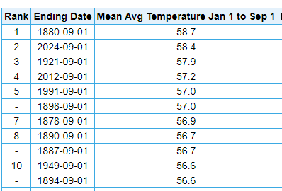
Nevermind. I guess it got so cold in 1880 that it fell way behind. 1921 is the year to beat at 55.4F. We currently have +0.5F on it. The rest of the year in 1921 was +5.9F, +0.7F, +2.1F, +0.3F, relative to 1991-2020 normals. Or about 2.2/2.3F above normal. Since the year is 2/3rd of the way through, 2024 could finish about 0.75F +/- cooler the rest of the way and still tie for the record. So we'd need to run roughly +1.5F, more or less, above the normal for the last 4 months, which is not too much to ask. -
Pittsburgh, Pa Summer 2024 Thread.
TheClimateChanger replied to meatwad's topic in Upstate New York/Pennsylvania
We might do it. We may break the annual temperature record if the CPC's fall outlook is accurate. Even with the warm bias in the 19th century data, it still used to get cold at times. Because it's not actually normal to go through a whole year without at least one cold month. Fall 1880 looks like this compared to 1991-2020 normals: September +1.1F; October +0.1F; November -6.9F, and December was -7F. Just a couple of decades ago, this would have been unthinkable. -
Pittsburgh, Pa Summer 2024 Thread.
TheClimateChanger replied to meatwad's topic in Upstate New York/Pennsylvania
Overall, CPC forecasts a warmer than normal fall, with no strong signal for precipitation in our region. Temperatures Precipitation -
Pittsburgh, Pa Summer 2024 Thread.
TheClimateChanger replied to meatwad's topic in Upstate New York/Pennsylvania
September looks to start on a comfortable note, as indicated by @ChalkHillSnowNut. The final CPC outlook for September issued yesterday shows equal chances for above, below and near normal temperatures and precipitation. Although parts of the region (north of I-80) are slightly favored for drier than normal conditions. Also odds are somewhat elevated for below normal temperatures just to the east of the mountains. Perhaps our best opportunity for a below normal month since last summer, although with this look [heat and dryness to our west], you have to wonder if there won't be at least one abnormal warm spell later in the month that might keep things on the warm side in the end. Temperatures Precipitation -
Pittsburgh, Pa Summer 2024 Thread.
TheClimateChanger replied to meatwad's topic in Upstate New York/Pennsylvania
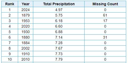
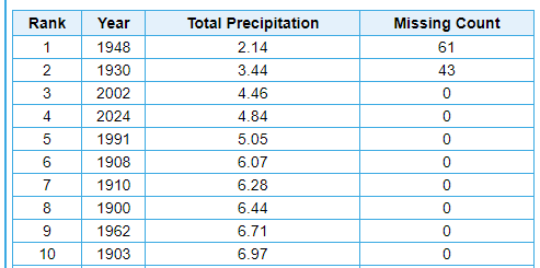
Precipitation wasn't particularly noteworthy at PIT, MGW, and DUJ. Somewhat below the median at the first two, but actually somewhat wetter than usual at DUJ. However, this summer was one of the driest on record in parts of southeast Ohio and northern West Virginia. At Zanesville, only 0.17" of rain fell in August, which was easily the driest August of record and the 5th driest of any month [1546 months of record] and the driest of any month in about 100 years: Driest summer on record at Wheeling, and by a significant margin. Was sitting at 3.66" just a couple days ago. 1879 is missing the entire months of June and July, and 1953 is missing data for the final 17 days of August. 2020 is the closest with full data. 2nd driest at Zanesville, among years with full data [2002 was drier]. 1948 is missing June and July, and thus should be tossed from the ranking. 1930 is missing scattered data. Sometimes blank data [for no precipitation] is interpreted as missing data, so it may be a legitimate number. There was a significant drought that summer in the region. Third driest if you include 1930. Easily the driest on record in the shorter POR at New Philadelphia: -
Pittsburgh, Pa Summer 2024 Thread.
TheClimateChanger replied to meatwad's topic in Upstate New York/Pennsylvania
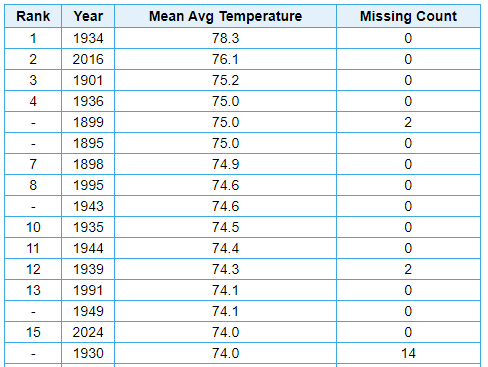
Some numbers from elsewhere in the PBZ County Warning Area: It was 5th warmest in the threaded record at Morgantown, among years with sufficient data (1892 is missing the entire month of June): It was 2nd warmest in the threaded record at Wheeling [no data for 1954-1997]: 15th warmest at Zanesville. Most of the warmer summers were prior to the airport site opening. Shorter period of record sites: 6th warmest (of 65 years) at New Philadelphia: Warmest summer on record at DuBois (out of 59 years): -
Pittsburgh, Pa Summer 2024 Thread.
TheClimateChanger replied to meatwad's topic in Upstate New York/Pennsylvania
It did indeed tick up to eighth place in the final rankings, albeit just barely. I was thinking it would get a bit warmer yesterday. -
Las Vegas Sees Its Hottest Summer on Record
TheClimateChanger replied to donsutherland1's topic in Climate Change
Thanks for the update, Don. It will be interesting to see whether 2024 was able to unseat 2021 and 1936 for hottest summer on a national scale. The fist two months of summer were in 2nd place, slightly behind 2021 and slightly ahead of 1936. While August was certainly warmer than normal, I feel like it was a bit cooler nationwide... so I think we may wind up just behind those years, but we'll see. Stay tuned. -
Pittsburgh, Pa Summer 2024 Thread.
TheClimateChanger replied to meatwad's topic in Upstate New York/Pennsylvania
For those keeping score, this comes on the heel of the warmest spring and fourth warmest winter on record. -
Pittsburgh, Pa Summer 2024 Thread.
TheClimateChanger replied to meatwad's topic in Upstate New York/Pennsylvania
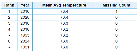
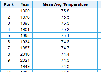
Haven't looked at this in a little while, but the recent heat wave locked up a top 10 warmest summer at Pittsburgh. Have to suspect that today and tomorrow will raise the August mean sufficiently to result in an increase of at least 0.1F in the summer mean, which would result in a tie or just ahead of 2016 for 8th place overall. Since 1901, only 2016, 1995 & 1934 were hotter in the threaded record [of course, the latter being when the station was still downtown]. -
Pittsburgh, Pa Summer 2024 Thread.
TheClimateChanger replied to meatwad's topic in Upstate New York/Pennsylvania
Wasn’t sure we’d get there today with the cloud cover, but it did reach 90F already. Might be about done though with thickening clouds and even some scattered thundershowers popping. -
A small area of exceptional drought (D4) noted in Ohio and West Virginia for the first time in both states since the drought monitor began in its current form in 2000.
- 231 replies
-
- absolute trainwreck?
- abandon all hope?
-
(and 1 more)
Tagged with:
-
Pittsburgh, Pa Summer 2024 Thread.
TheClimateChanger replied to meatwad's topic in Upstate New York/Pennsylvania
Looks like the morning low was 74F, which would be a record high if it holds. It might not though, due to risk of thunderstorms. Current record high minimum is 73F from 1928. -
Occasional Thoughts on Climate Change
TheClimateChanger replied to donsutherland1's topic in Climate Change
-
I actually said "nearly without historical precedence" as @rainsucks suggested 100-101F. Another degree above that would indeed be without any historical precedence; hence, my use of the qualifier "nearly." In other words, those values are rare but not unprecedented, but anything higher would be unprecedented in the historical record.
- 231 replies
-
- absolute trainwreck?
- abandon all hope?
-
(and 1 more)
Tagged with:
-
Very interesting to watch the impact of the extreme drought on temperatures. Parkersburg, West Virginia looks poised to approach 100F today, which has only happened in 8 years from 1926 to the present (29 times), and only two years since 1954 (a total of 8 times - 7 in 1988 & 1 in 2012).
- 231 replies
-
- absolute trainwreck?
- abandon all hope?
-
(and 1 more)
Tagged with:
-
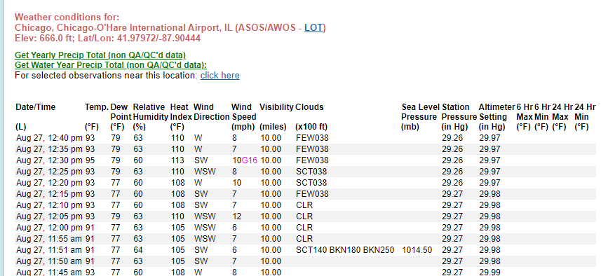
Either way, dangerous heat. Always a lot of trolling on here when it gets hot. I even saw someone making light at all of the EHWs. I think people forget that conditions like these are highly unusual for the Midwest in the month of August, let alone late August. The unofficial 113F value at 12:30 p.m. is not far off of last year's record-breaking pace. I know someone also questioned me on claiming 100F is unusual for this time of the year in Chicago, by pointing out the 100F high on August 24th of last year. That was the latest in the threaded record since the 100F reading in early September 1960, observed at Midway. It was actually 99F at O'Hare on that date, and last year's 100F reading was the latest observed at O'Hare by three full weeks. So I don't know what point they were trying to make. Chicago Area Hourly Heat Index Records (1946-present)
- 231 replies
-
- absolute trainwreck?
- abandon all hope?
-
(and 1 more)
Tagged with:
-
Eyeballing it, I think 98/61 looks like a Weathergami. Certainly not much population density there, either way. If it is a Weathergami, that would be 3 new combinations in 4 days with nearly 100 years of records.
-
Due to the unusual weather conditions, Weathergamis were observed on Friday (89F/49F) and Sunday (96F/58F). Saturday's 94F/53F apparently occurred on one other occasion. I suspect yesterday (98F/61F) must have been close to a Weathergami as well. Will have to keep an eye when that data is released later.
-
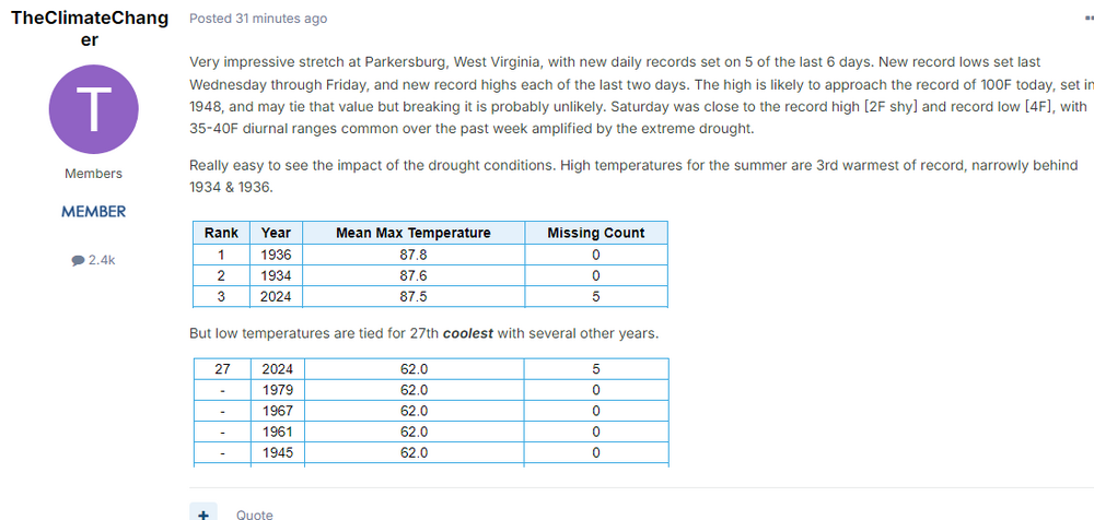
Very impressive stretch at Parkersburg, West Virginia, with new daily records set on 5 of the last 6 days. New record lows set last Wednesday through Friday, and new record highs each of the last two days. The high is likely to approach the record of 100F today, set in 1948, and may tie that value but breaking it is probably unlikely. Saturday was close to the record high [2F shy] and record low [4F], with 35-40F diurnal ranges common over the past week amplified by the extreme drought. Really easy to see the impact of the drought conditions. High temperatures for the summer are 3rd warmest of record, narrowly behind 1934 & 1936. But low temperatures are tied for 27th coolest with several other years.
-
Pittsburgh, Pa Summer 2024 Thread.
TheClimateChanger replied to meatwad's topic in Upstate New York/Pennsylvania
KPIT is up to 91F again. Still suspect we'll make a run for hottest of the year, probably 93-95F range for the high temperature. -
Not quite up to last year's historically high August heat indices in most places, but not far off. Here's Moline's highest heat index readings by hour in the month of August [1929-present]. The 10 a.m. reading of 100F is 5F shy of August 23, 2023.
- 231 replies
-
- absolute trainwreck?
- abandon all hope?
-
(and 1 more)
Tagged with:
-
Looking through the climate numbers for the day and one of the more notable readings was 97F at Traverse City. That was the highest reading there since June 30, 2018, when it reached 98F. It was the highest reading in the month of August since August 8, 2001, when it reached 98F. Furthermore, since 1968, there have only been two days in the month of August on which it was as warm or warmer than today's reading - August 2, 1988, when it reached 98F, and the aforementioned date in 2001.
- 231 replies
-
- absolute trainwreck?
- abandon all hope?
-
(and 1 more)
Tagged with:
-
Pittsburgh, Pa Summer 2024 Thread.
TheClimateChanger replied to meatwad's topic in Upstate New York/Pennsylvania
Wasn't super unexpected to me, although admittedly the official forecast had mid 80s for Allegheny County today. I commented yesterday that it would likely be close to 90F today, based on a review of the models - most of which were showing upper 80s, with the HRRR in the low 90s - and upstream observations with widespread low to mid 90s the prior day. NWS has 92F at the airport each of the next two days... personally, Wednesday looks like the hottest day of the year to me on the short-range modeling. Not sure why the NWS is going so much lower than they did with the June heat wave - maybe concern about clouds and convection, I'm guessing? A number of models have mid to upper 90s for Wednesday, and upstream observations are supportive. 96F in New Philadelphia was a new record, and just 3F shy of the monthly record. Reached at least 98F at Parkersburg, W. Va. for the second straight daily record high, and only 3 or 4F shy of the monthly record. Regardless, if we do 90+ tomorrow, Wednesday and Friday, as per the official forecast, PIT would have 23 90+ days in meteorological summer. That would tie 1966, 1901 & 1884 for 12th most on record. Excluding the suspect 19th century data, only 2 met. summers had more 90+ days since 1900 - 1988 (37) and 1995 (26). -
Pittsburgh, Pa Summer 2024 Thread.
TheClimateChanger replied to meatwad's topic in Upstate New York/Pennsylvania

