TheClimateChanger
Members-
Posts
2,704 -
Joined
-
Last visited
Content Type
Profiles
Blogs
Forums
American Weather
Media Demo
Store
Gallery
Everything posted by TheClimateChanger
-
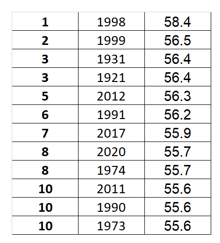
IMO, dense ranking makes little sense for most climatological data. The important takeaway in climate ranking isn't how many times an specific, unique value has been achieved, it's how a given year compares to prior years. If there were seven warmer years, then the next highest should be in 8th - regardless of whether there were only 5 unique values higher. But anyways, the implication from the original response that led to this thread isn't correct either. Rankings that are tied are denoted with an asterisk on the map. If there are three years in fifth place, then it will show 5* for the ranking. The next highest on those SERCC maps would be 8th place, as they use traditional ranking. It's not really that important, however, as there typically aren't that many ties as you get into the extreme values in the dataset. There's generally more extremes/outliers at the tails. Obviously, occasionally there will be 2 or 3 years tied. But it's much more frequent to have many years with the same value near the means and median of the dataset. Sometimes in the longer datasets, there might be 5 or 6 tied years near the middle. Not really relevant when talking about top 5 values. Even though, it's common to say normal isn't relevant and it's always either hot or cold. That isn't actually true. The reality is the highest percentage of years are typically around the mean/median (even though that's less true today in a warming climate).
-
Central PA Summer 2023
TheClimateChanger replied to canderson's topic in Upstate New York/Pennsylvania
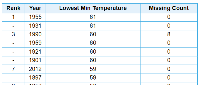
Wow, impressive stuff. Rounding for consistency with the historical records, that's a monthly minimum of 60F. Looks like that only happened 6 times in 114 years at the West Chester Coop site, and the 1990 data is suspect due to more than a quarter of the month's data being missing. The current monthly mean minimum you have observed was only exceeded in 14 years, although I assume that's not including this morning's cooler low temperature. Must be runaway urban heating from Philadelphia, or perhaps the hot air blowing in from all of the politicians and bureaucrats in DC. -
Pittsburgh/Western PA Summer 2023
TheClimateChanger replied to Ahoff's topic in Upstate New York/Pennsylvania
Looks like a fairly dense pall of smoke aloft tomorrow. -
The rankings themselves are kind of misleading, because there are a lot of places on there in 5th, 6th position, but all of the higher years are just within the past 10 years. Just 15 years ago, many of those red areas would probably be maroon.
-
Yes, low temperatures have been absolutely scorching in many places. Everybody likes to focus on the high temperatures, but to me the humidity and excessively warm low temperatures are worse than extreme high temperatures and lower humidity. The focus is always on temperature, but if dew points and temperatures are both climbing - which appears to be the case - then apparent temperatures are probably climbing at a rate two or three times faster. It used to cool off into the 50s regularly where I am from, and now it seldom drops below 60. There used to be July evenings where a hoodie would be appropriate because it was already in the low 60s by 9 or 10 pm, with morning lows in the 40s. Obviously the exception, not the rule. But those days simply do not happen anymore.
-
These 1991-2020 normals aren't doing us any favors in showing the reality of climate change. I see so many comments here and on X implying it hasn't been a hot summer. Here is an example: Here is an example from the NWS, providing "perspective" on the heat: The implication of maps like these is that it's been a fairly normal summer with warm anomalies and cool anomalies roughly evening out. The reality is the map posted in the thread I linked to above shows a departure for June and July of +0.45F above the 1991-2020 mean. Obviously, these are unofficial values. If NCEI has the same departure, this would be the 20th warmest June & July period on record (out of 129 years). If we exclude 21st century data, and limit this to the 1895-2000 period (106 years), there are only seven hotter years - 1936, 1934, 1933, 1931, 1988, 1921, and 1952. So four dust bowl years, one of the worst droughts on record, and a couple of notoriously hot summers (including one during the 1950s drought period). We're running hotter nationally than notoriously hot years like 1995, 1991, 1999, 1983, 1953, 1954, etc... Heat was a front page item in these years. Why do people think there's too much coverage of the heat? Make no mistake about it, before the advent of widespread artificial cooling, there would be thousands of deaths in years like this. If the NWS outlook for August verifies (which is showing warmer than average temperatures across probably 80% of the CONUS), I think we will be looking at a top 10, or certainly top 15, hottest summer on record nationally. Might even be top 5 if you exclude years in the 21st century.
-
Central PA Summer 2023
TheClimateChanger replied to canderson's topic in Upstate New York/Pennsylvania
If the NWS forecast for August verifies, I think we’d be looking at a top 10-15 summer nationally. It’s like if we don’t set a new record every year, it’s no big deal. -
Central PA Summer 2023
TheClimateChanger replied to canderson's topic in Upstate New York/Pennsylvania
Actually, looking a little closer at the map, it indicates this year has been 0.45F above the 1991-2020 mean. Using that anomaly, this would be the 20th warmest (of 129 years). I believe this is the better way to compare this data to the official numbers, since they might calculate somewhat different means. -
Central PA Summer 2023
TheClimateChanger replied to canderson's topic in Upstate New York/Pennsylvania
A bit of a straw man. No one has said it’s been the hottest summer on record in the US. With that said, the map is a bit misleading. It looks like it’s pretty typical but in reality it has been more than 1 degree above the 20th century mean. Obviously, these are unofficial, preliminary numbers, and the mean will likely tack on another tenth or so as the last two days of July are incorporated into the mix. Even so, this would be 29th warmest (of 129 years). Limiting to years prior to 2000, it would be 14th warmest (of 106 years). So it’s still a very warm start to summer nationally either way. I suspect the official ranking for that period to be somewhat higher. -
Agreed - that was a bunch of nonsense peddled by CWG, as per usual. No mention of the HO-83 hygrothermometer in use at all of the airports from the mid 80s until mid/late 90s, which had a warm bias in excess of that amount - particularly, for daytime maxima in light wind and sunshine. A lot of heat records set during that era, particularly in the summertime. But we have blasted past those years. To analogize to baseball and the steroid era, it would be akin to a bunch of players, not using steroids, suddenly hitting 80-90 home runs every year. And Barry Bonds' record was being eclipsed regularly. The difference between IAD and DCA this year is 2.7F, which if it holds would be the ninth smallest difference between the two sites on record. The difference this month has been just 1.5F. No calls for an investigation. No national scandal. Wonder why?
-
The big difference was those winters were ridiculously cold out west. Several recent winters have just been coast-to-coast blowtorches. 1950 also finished out as a pretty chilly year overall, capped by The Great Appalachian Snowstorm with unprecedented November cold and snow.
-
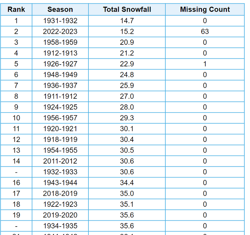
Also, Elkins (~2000 feet) had its second least snowy winter on record in 2022-2023. Elkins was poised to obliterate the 1931-32 record, but some late season snowfall pushed last winter into a close 2nd place. Below is the top 20 least snowy winters in Elkins. A lot of them are quite old, and I think some of that is attributable to changing measurement techniques. In the past, it was common just to measure depth changes or attribute a 10:1 ratio to the melted snow. They certainly weren't using snowboards. Regardless, 4 of the top 20 have occurred in fairly recent years. If it simply doesn't snow, it doesn't matter how the measuring techniques have changed, because there's no snowfall to inflate.
-
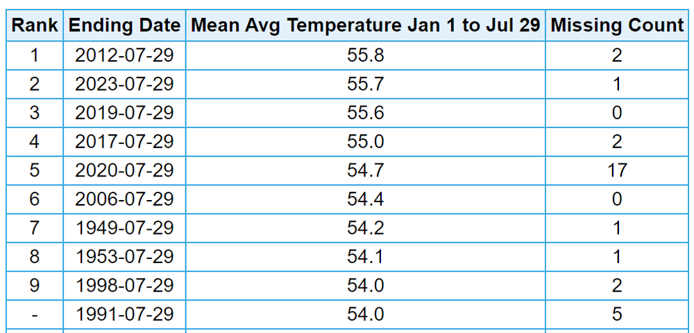
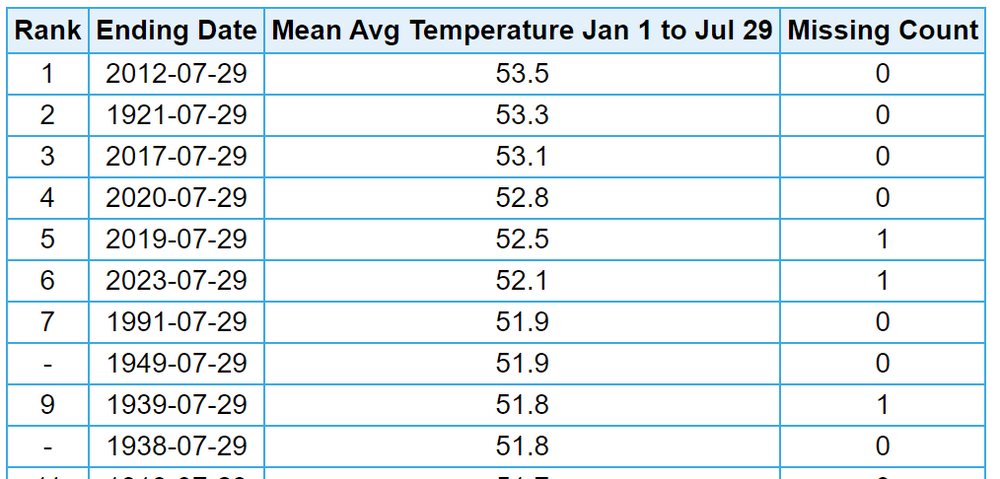
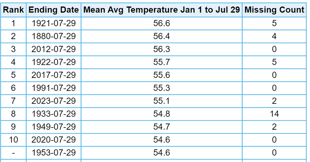
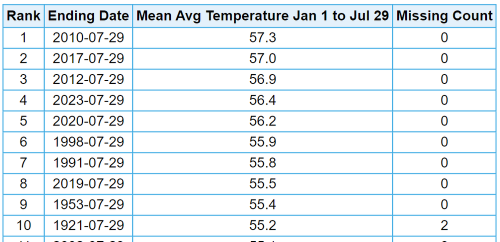
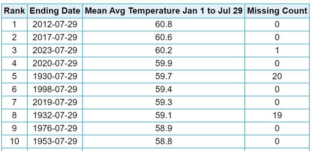
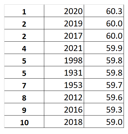
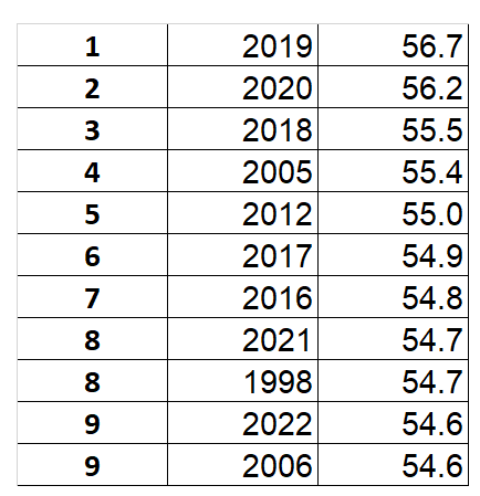
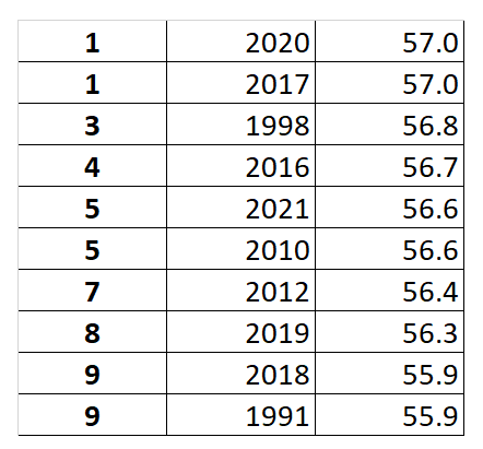
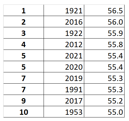
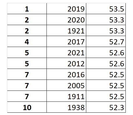
The "extreme run" has continued into 2023. Here are some rankings for smaller communities in the greater Mid-Atlantic region. One thing that's interesting is when you look at shorter time frames, you tend to get more years in the past. However, in that era, there would be cooler periods that would often drop them in the rankings. In the current "extreme run" era, the heat is just relentless. Clarksburg, WV - 2nd warmest to date Elkins, WV - 6th warmest to date Morgantown, WV - 7th warmest to date Hagerstown, MD - 4th warmest to date Charlottesville, VA - 3rd warmest to date [NOTE: A lot of missing data for 1930 & 1932. Since this is calculated by averaging days, those years may be inflated if the missing data is from early in the year when mean temps are cooler.]
-
Careful. If there's one thing I've learned in my 25-odd years in these weather communities, it's that you need to use euphemisms like "extreme run" or "runaway urban heat island effect" or the "never-ending runaway Lezak recurring warm cycle."
-
Here are the Top Ten warmest years at several other sites in the greater Mid-Atlantic region. This runaway urban heat island effect is serious sh*t. Charlottesville, VA - 7 of top 10 since 2012 Clarksburg, WV - 8 of top 10 since 2012, 9 of top 10 since 2005 Hagerstown, MD - 8 of top 10 since 2010 Morgantown, WV - 6 of top 10 since 2012 Elkins, WV - 6 of top 10 since 2012, 7 since 2005 Martinsburg, WV - not sure what was going on with the sensor in the late 90s, but still 4 of top 10 since 2011
-
Pittsburgh/Western PA Summer 2023
TheClimateChanger replied to Ahoff's topic in Upstate New York/Pennsylvania
High of 94F today at Morgantown. With today's extreme heat, I thought it would be a good opportunity to look at the climatology of extreme heat in the region. Here are the most recent dates of 100+ at the regional climo sites: Morgantown, New Philadelphia, and Zanesville: 7/7/2012 DuBois: 7/22/2011 [only date on record with 100+] Pittsburgh: 7/15/1995 [back in the good ol' days when PIT used to be the warmest spot in the region] Wheeling: 7/18/1942 [large gap in the threaded record from 1953 until 1998] -
Pittsburgh/Western PA Summer 2023
TheClimateChanger replied to Ahoff's topic in Upstate New York/Pennsylvania
Should the criteria be 100 though? The criteria is only 95 at Syracuse even though they have averaged 3 more 90+ days and 1 more 95+ day per year than Pittsburgh over the last 25 years. It doesn’t make much sense for our criteria to be higher than locations more prone to extreme heat. -
Pittsburgh/Western PA Summer 2023
TheClimateChanger replied to Ahoff's topic in Upstate New York/Pennsylvania
Looks like all of the construction at the airport is helping to increase the temperatures there. Up to 91 now. -
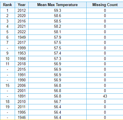
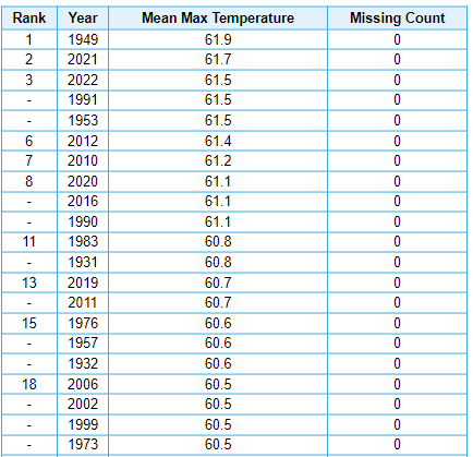
There have been incredible afternoon oddities across New England. They've just become normalized. Apparently, unless it's 100 degrees, it's not that hot. Look at BTV - top five highest mean maximum all since 2012, with 2012 being nearly 1.5 degrees higher than the prior record. Burlington, VT Similar pattern in Boston, despite being located right on the Harbor - which you would think would be cooler. You know the ol' "cooler by the water" meme? Boston, MA This is incredible, extraordinary stuff. There's no other way to characterize this. In any other era, a stretch like this would be headline news every single day. Only our advanced technology is preventing mass crop failures, famine and starvation. In the old days, they would be counting the bodies after heat like today. They called them "prostrations." No doubt our cooling technology has saved countless lives.
-
Looking at a chart like that, you have to expect some profit taking here at the top. If not, it could be off to the moon.
-
Central PA Summer 2023
TheClimateChanger replied to canderson's topic in Upstate New York/Pennsylvania
Are they sure there's no missing data in that Sarasota reading? That seems absurdly dry for Florida. -
Yes, you are correct. I took a look at the period of overlap between ORH and the city station (1948-1962). The city station did average about a degree more in the annual means; however, there was a distinct seasonality to the temperature differences. It was about 1.5-2 degrees warmer in January, but the differences were very small in July (with the city being generally less than 0.5 of a degree warmer). I believe the difference is because radiational cooling has an oversized impact in the warm season. Winter is cloudy and windy, so radiational cooling effects are minimized. The lower elevation city site in the valley radiates better than the surrounding hills, even despite the development around the site. This difference largely offset the elevational cooling in the summertime, but not in winter.
-
Impressive heat this month. Even ORH is in 6th place, with the opportunity to move up even more over the next couple of days. Due to the airport site being about 500' above the city of Worcester (a cooling effect of 1.5-2.5F), it is very difficult to set new warm monthly temperature records there particularly in the summertime when there is less internal variability.
-
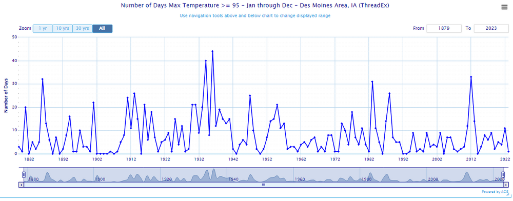
The use of data from Cedar Rapids also makes the trend look more pronounced. Cedar Rapids is often one of the cooler spots in the state of Iowa. The early records have an unbelievable number of days of 95+. It's not believable that Cedar Rapids would have experienced more days of 95+ than Des Moines in those years. That makes no sense climatologically. The data for Des Moines also show a trend towards less, but not nearly that pronounced.

