

TheClimateChanger
-
Posts
2,462 -
Joined
-
Last visited
Content Type
Profiles
Blogs
Forums
American Weather
Media Demo
Store
Gallery
Everything posted by TheClimateChanger
-
Occasional Thoughts on Climate Change
TheClimateChanger replied to donsutherland1's topic in Climate Change
You have to wonder what effect all of this smoke is having from these supercharged, anthropogenic wildfires? Smoke has a massive cooling effect, absorbing, and to some extent, reflecting incoming solar radiation, while mostly transparent to outgoing longwave radiation. There are also a number of studies showing a significant indirect cooling impact through cloud brightening. The smoke particles and aerosols act as cloud condensation nuclei. Since they are more abundant, you wind up with clouds that contain more droplets and are, therefore, brighter or more reflective; however, the droplets are smaller and less apt to produce rainfall. There is also a direct drying effect by limiting convection through cooling of the near surface layer, while warming the air aloft. Both of these would impact surface convection, and through warming aloft, there's probably an impact even on elevated convection. Maybe it's just me, but it seems like the smoke has really ramped up globally since about the mid 2010s. We have even seen a number of significant pyroCb events which can loft the smoke and aerosols into the lower stratosphere where they can have a much longer residence time similar to volcanic emissions. You don't see this latter effect with ordinary industrial pollution. -
Pittsburgh/Western PA Spring 2023 Discussion
TheClimateChanger replied to Ahoff's topic in Upstate New York/Pennsylvania
Dewpoint of 33F at 7 pm is about as low as it gets this time of the year. Sorry for including June 1. When I selected start and end date of 5/31, it ran the numbers for the entire year. Just missed the lowest for that hour by two degrees. The dewpoint was 31F at 7 pm on May 31, 1984.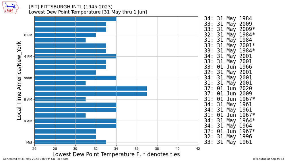
-
Dewpoint down to 26F at Akron: https://w1.weather.gov/data/obhistory/KAKR.html
-
Pittsburgh/Western PA Spring 2023 Discussion
TheClimateChanger replied to Ahoff's topic in Upstate New York/Pennsylvania
-
Central PA Spring 2023
TheClimateChanger replied to Itstrainingtime's topic in Upstate New York/Pennsylvania
Looks like the dry pattern will persist for awhile. -
Central PA Spring 2023
TheClimateChanger replied to Itstrainingtime's topic in Upstate New York/Pennsylvania
NOAA predicted the drought in SE Pennsylvania would end this month, so they are going to make sure that it ends even if it was the driest month on record. U.S. climate outlook for May 2023 | NOAA Climate.gov -
Pittsburgh/Western PA Spring 2023 Discussion
TheClimateChanger replied to Ahoff's topic in Upstate New York/Pennsylvania
I was wondering this too, and it prompted me to do some research. Based on what I observed, the presence of smoke does have a cooling and drying effect (at least during the warm season, when fires are more ubiquitous). Wildfire smoke can reduce convection by lowering surface temperature by up to several degrees. I wonder too if the absorptive quality of wildfire smoke which can result in warming of the atmosphere in the layers where smoke is present might also contribute to this effect, since there would be both a decrease in temperature in the lower atmosphere and an increase in temperature in the upper atmosphere, both of which would supress updraft intensity. Unlike cloud cover, smoke is supposedly mostly transparent to outgoing long-wave radiation, so has only a small warming effect overnight. In areas subject to a marine layer or high humidity, this cooling effect can enhance cloudiness and result in increased persistence of a low stratus deck and/or fog. Additionally, the smoke alters the microphysics of clouds. The aerosol acts as cloud condensation nuclei, which can enhance cumuliform cloud cover. The abundance of cloud condensation nuclei results in clouds that have consist of more, but smaller, droplets. The increase in droplet density results in brighter clouds [higher albedo] which results in an additional indirect local cooling effect, when clouds are present. However, because droplet size is less, the clouds may produce less rainfall, or be less apt to produce rainfall. -
Pittsburgh/Western PA Spring 2023 Discussion
TheClimateChanger replied to Ahoff's topic in Upstate New York/Pennsylvania
Crazy diurnal ranges outside of the urban heat island. Zelienople Municipal Airport [National Weather Service : Observed Weather for past 3 Days : Zelienople Municipal Airport]: 26: 72/37 27: 81/37 28: 79/41 29: 88/52 30: 84/52 31: NA/46 Low of 46 in Zelie this morning, looks like another day with highs in the mid to upper 80s. Tomorrow night will probably drop back into the upper 40s/lower 50s, with a high approaching 90. Point-click has 88/51 there tomorrow, but I'd say there's a decent chance of a rare combo of lows in the 40s, and highs 90+. -
Central PA Spring 2023
TheClimateChanger replied to Itstrainingtime's topic in Upstate New York/Pennsylvania
Must be some local cooling effect. Mount Pocono is the coolest in the state at 69, even Bradford is 77 and Erie is 81. -
Central PA Spring 2023
TheClimateChanger replied to Itstrainingtime's topic in Upstate New York/Pennsylvania
Haven't seen this mentioned anywhere, but the RAP-SMOKE model brings in a substantial amount of near-surface smoke later tonight. Looks to spread across eastern PA tomorrow, so expect hazy skies and poor air quality. The smoke wrapped all the way across the Hudson and into the Atlantic, dropped near the surface over the oceanic inversion layer and is being pushed westwardly by easterly winds. -
I just noticed that, and was going to share it. That is a significant amount of near-surface smoke, so expect a rapid degradation in air quality later today.
-
Central PA Spring 2023
TheClimateChanger replied to Itstrainingtime's topic in Upstate New York/Pennsylvania
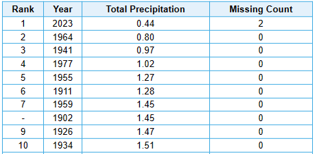
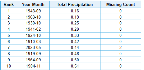
Will also easily go down in the record books as driest May on record at IPT: Seventh driest month overall: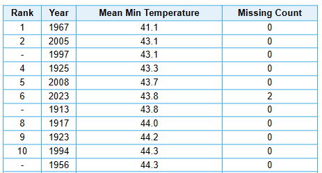
-
Central PA Spring 2023
TheClimateChanger replied to Itstrainingtime's topic in Upstate New York/Pennsylvania
Will probably move down the list a bit when today and tomorrow are factored in, but with two days remaining in the month, the mean minimum temperature is sixth lowest on record at IPT.
-
Central PA Spring 2023
TheClimateChanger replied to Itstrainingtime's topic in Upstate New York/Pennsylvania
-
Spring 2023 Medium/Long Range Discussion
TheClimateChanger replied to Chicago Storm's topic in Lakes/Ohio Valley
Absolutely insane. Can you imagine the ticks and rodents? Lyme disease infected ticks everywhere, and they are pushing this nonsense. It's a public health hazard and nuisance. If the people pushing this trend want to live among unmowed lawns, they should move to a rural area, and vacate the cities and suburbs. -
E PA/NJ/DE Spring 2023 OBS Thread
TheClimateChanger replied to Hurricane Agnes's topic in Philadelphia Region
I wonder to what extent the cool and very dry weather is attributable to the smoky atmosphere that has been in place over the eastern US this month. Wildfire smoke is known to reduce temperature by absorbing and, to some extent, reflecting solar radiation in the upper troposphere (and even into the stratosphere if it's hitched a ride there on towering pyroCb clouds), and by altering cloud microphysics which can increase the brightness and reflectivity of clouds. It can also reduce rainfall by weakening instability and the resultant convective updrafts, and by the same microphysical cloud changes. I wonder, too, if by warming the upper atmosphere, it might even lessen elevated convection, since there would be weaker lapse rates due to the smoke. On the plus side, the filtered solar radiation should result in somewhat reduced evaporation rates. -
Oh, boy. https://www.nytimes.com/2023/05/22/world/americas/mexico-volcano-popocatepetl-eruption.html
-
-
-
Central PA Spring 2023
TheClimateChanger replied to Itstrainingtime's topic in Upstate New York/Pennsylvania
The combination of drought, unseasonable frosts, smoky skies and brilliant sunrises and sunsets is somewhat reminiscent of 1816. Not saying we're going to have a year without a summer this year. -
Central PA Spring 2023
TheClimateChanger replied to Itstrainingtime's topic in Upstate New York/Pennsylvania
A lot of that is just elevation. MDT is 300 feet ASL, whereas PIT is 1200 feet ASL. Temperatures decline about 3-4 degrees, per 1000 feet rise. If records were still taken downtown (700-ish feet, plus UHI), there probably would be a handful of additional 97 degree readings in that timeframe. MDT also benefits from being downwind of the mountains, so downsloping effects can even enhance these differences on the hottest days. -
Central PA Spring 2023
TheClimateChanger replied to Itstrainingtime's topic in Upstate New York/Pennsylvania
I recall this event: https://www.wpc.ncep.noaa.gov/research/roth/landcane.html -
What's all that in Mexico? Hopefully, Popo isn't about to blow its top.
-
ORD, MDW and MKE all reporting a broken smoke deck at 25,000 feet, with scattered clouds of smoke at Indianapolis at the same altitude. Will be interesting to see what effect this has on temperatures. MSP reported highs several degrees below modeled levels yesterday. KMDW 181353Z 14009KT 10SM BKN250 13/M02 A3009 RMK AO2 SLP191 FU BKN250 T01331017 KORD 181351Z 15012KT 10SM BKN250 13/M02 A3008 RMK AO2 SLP188 FU BKN250 T01331022 KMKE 181352Z 17006KT 10SM BKN250 13/03 A3008 RMK AO2 SLP189 FU BKN250 T01280033 KIND 181354Z 10006KT 10SM SCT250 13/02 A3009 RMK AO2 SLP187 FU SCT250 T01280022
-
Sounds like the thick pall of smoke kept temperatures depressed several degrees in Minneapolis-St. Paul today.


