TheClimateChanger
-
Posts
4,598 -
Joined
-
Last visited
Content Type
Profiles
Blogs
Forums
American Weather
Media Demo
Store
Gallery
Everything posted by TheClimateChanger
-
Occasional Thoughts on Climate Change
TheClimateChanger replied to donsutherland1's topic in Climate Change
The characterization of the Medieval Warm Period on Encyclopedia Brittanica versus Wikipedia is telling. Wikipedia presents it as uncontroverted fact, whereas here is how it is presented on Encyclopedia Brittanica: Note it's a hypothesis, the extent of which is disputed among experts [i.e., whether it was a global phenomenon or if it even existed at all]. The graphic shown illustrates Mann's and Jones' reconstructions of Northern Hemisphere temperatures since 1000 C.E., and also includes H. H. Lamb's original reconstruction of Central England temperatures over the same interval [as presented in his 1965 work, which as best as I can tell was the first piece of scholarship to formerly characterize the MWP as a possible widespread event]: This CET reconstruction is extremely flimsy. The proxies used didn't support such a massive jump. They were adjusted by Lamb to produce that effect... read the paper and see how many adjustments [on questionable assumptions] were made to produce that level of warming. The same thing climate deniers accuse scientists of doing today. The timing doesn't even make sense. Icelandic records of sea ice suggest cooling with lots of heavy sea ice conditions in the 1200s and 1300s. 1348 was said to be perhaps the coldest winter. How would there be such a huge disconnect between Iceland and central England? Like I said, I'm just trying to figure out why there are so many that believe it was a period of no snow in North America, and what evidence there is to support that? There doesn't seem to be any. -
Occasional Thoughts on Climate Change
TheClimateChanger replied to donsutherland1's topic in Climate Change
The point is we have had people for decades treating AGW as some unproven theory, while past climate changes are accepted as 100% fact [and often grossly exaggerated]. In fact, the evidence for AGW is obviously 100s of times greater than any supposed evidence of these past eras. And indeed, most modern temperature reconstructions suggest the MWP was perhaps a 0.5C warmer than the heart of the LIA [not at all warmer than the present], and perhaps on par with the start of the 20th century on a global average. By all reliable measures, it was far colder than the present era on a global scale. Yet, there are some here who, even today, believe it was some period where it never snowed and winters torched all year around. What is the evidence for this nonsense? In fact, if you attribute knowledge of the modern greenhouse effect to Svante Arrhenius, the characterization of the greenhouse effect [and the impact of carbon on the climate] far predates any formal characterization of the MWP? Yet, some say the modern reconstructions are "erasing" the MWP? The greatest minds living in the LIA looked at the same evidence that some trot around and concluded [correctly] that there was no massive change in climate. Obviously, they didn't have access to ice cores and tree rings, and things of that nature, that do provide support for some measure of warming, but much of the discussion is just nonsense. I mean you can make the same argument these folks make and say the MWP was "invented" in the late 20th century specifically to obfuscate the reality of human-caused climate change. -
Occasional Thoughts on Climate Change
TheClimateChanger replied to donsutherland1's topic in Climate Change
Yes, I know all that. I never really looked into the medieval warm period, and assumed it was more robust and significant based on how people refer to it on this website. They make it sound like the Eocene or some period of eternal warming. But many of the lines of evidence to support that appear to be superstitious hocus pocus. Would it surprise people to learn that grapes were successfully grown in parts of England for winemaking even during the heart of the so-called little ice age? And there are plenty of vineyards today in England. Why is so much significance given to the cultivation of grapes in medieval times? No special significance was afforded this by the great minds of the past, with evidence of cultivation being rather limited, and evidence that the wine was of low class. There was no need to grow grapes in England in the 19th century, when fine wines could be imported from France and Italy. Would it surprise people to learn that the opposite was said to be true around the Black Sea and surrounding parts of Europe? That is, grapes were said to be cultivated in places in the so-called Little Ice Age where there was no prior record of their cultivation? Would it surprise people to learn that the native "forests" of Iceland were principally shrubby bushes, as they are today, unsuitable for most building? And the Viking sagas considered it a great feat that two of the early settlers were able to assemble enough wood to build a boat to sail to Norway. The Viking sagas describe Vinland as a place with nearly equal day and night, but where on the shortest day, the sun rises at 7:30 and sets at 4:30. I don't know about you, but that doesn't sound like L'Anse Aux Meadows to me. The Viking settlements at Greenland may have failed, but there is little concrete evidence of the role climate change played. Mostly, it was mismanagement, and loss of trade/contact with the mother country which was in the throes of the Black Death. It's likely there was disease and epidemics in the colonies as well. Much significance is attached to cultivation of barley in Iceland during the medieval times, yet in Scotland, the range for cultivation of grains was both northward and higher in altitude than in its historic range during the LIA than during the MWP [which was attributed by the writers to advancements in agriculture, not evidence of climate change]. -
Occasional Thoughts on Climate Change
TheClimateChanger replied to donsutherland1's topic in Climate Change
File this under controversial, but I was doing some "light" reading on the climate from past authorship in the early/mid 19th century over the holiday as I enjoy reading about past climate. I was rather surprised that the great minds of the 18th and early 19th century did not believe there was any appreciable change in climate from antiquity. In fact, this was the prevailing school of thought into the first half of the 20th century. The modern idea of a "medieval warm period" did not really arise until 1965 with H. H. Lamb's publication on the matter, although that built off scholarship from the preceding few decades. I reviewed that article, and found the persuasiveness somewhat lacking. Evidence against a large change was repeatedly dismissed, and when proxy evidence did not correspond to the desired result, it was adjusted and then adjusted some more. The timing of the supposed warm period even seems inconsistent with the modern view - showing warming most pronounced in England from like 1100-1300 CE, whereas now it's more like 800-1000 CE. Icelandic records of sea ice are suggestive of a climate in the North Atlantic much colder than present by the early/mid 13th century (and even colder than the 19th century), but these are dismissed by Lamb. It looks like the idea of a medieval warm period reached its zenith in 1990, with the publication of the first IPCC report, which had an absurd hump for the medieval warm period extending even into the 14th century, despite loads of evidence that it was significantly colder in the 13th and 14th centuries. Hmmm, I wonder why that graphic made it in there? Modern reconstructions such as that appearing in more recent IPCC publications instead show a slight and gradual cooling trend over the entire millenia, abruptly ceasing in the 19th century. The medieval warm period is a small blip in the record. It would appear modern research largely confirms the prevailing scientific wisdom of the 18th and 19th century that there was no significant change in climate in the preceding 2000 years. Personally, I attach great significance to the conclusions of this era, since we are told these scientists and fathers of modern meteorology and climatology were living in the end of a "little ice age." Despite this, they looked at the same evidence we have and concluded there was no significant change in climate from the so-called medieval warm period to the era in which they were living. They may have had access to even more records which have been lost to the hands of time. Yet, some here today like to claim the medieval warm period was even warmer than our current globally-warmed times. These scientists also weren't burdened by the "woke" nonsense of today and would have had no pecuniary interest in their findings. AGW wasn't even known in that era... their only motivation was a desire to find the scientific truth. No money was being showered upon them by vested interests. Despite the foregoing, it would seem many here - even those who accept the scientific reality of anthropogenic climate change - attach an unreasonable significance to the medieval warm period, suggesting it may have been as warm and snowless as recent years. I feel like Band-Aid, except instead of "Do they know its Christmastime at all," it's "do they know the current era is far, far warmer than the so-called medieval warm period?" as per the most reliable temperature / climate reconstructions? What's the truth here? Is there even a medieval warm period and little ice age, or was it more or less, just a natural prolonged and gradual climatic cooling that was interrupted by human activities? Some say it was only a "local" phenomenon and not global. But user @blizzard1024made a good point about this some years back. That's not how the atmospheric circulation works. It seems suspect that there would be sustained local anomalies of warm and cold in a global system. He, of course, concluded that means the medieval warm period was a global phenomenon. But another conclusion that can be drawn is that there simply wasn't a medieval warm period of any significance, local or otherwise, and the temperature departures from that era were not anything significant? More credence ought to be given to the formerly prevailing view of a largely static climate regime over the past 2,000 years. After all, the scientists who reached this conclusion were living in the very region said to be most affected by the MWP and LIA and could find no strong evidence of cooling from the published records and local histories. Modern temperature reconstructions appear more consistent with this view than the one that had its brief zenith in the mid to late 20th century of much more significant global temperature changes. @donsutherland1 @Typhoon Tip -
Central PA Winter 2024/2025
TheClimateChanger replied to Voyager's topic in Upstate New York/Pennsylvania
You guys think we can get an Ohio State & Penn State rematch for the natty? Penn State got an easy bracket. Just need to get by the Georgia/Notre Dame winner. -
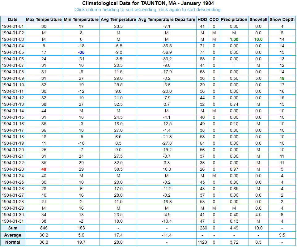
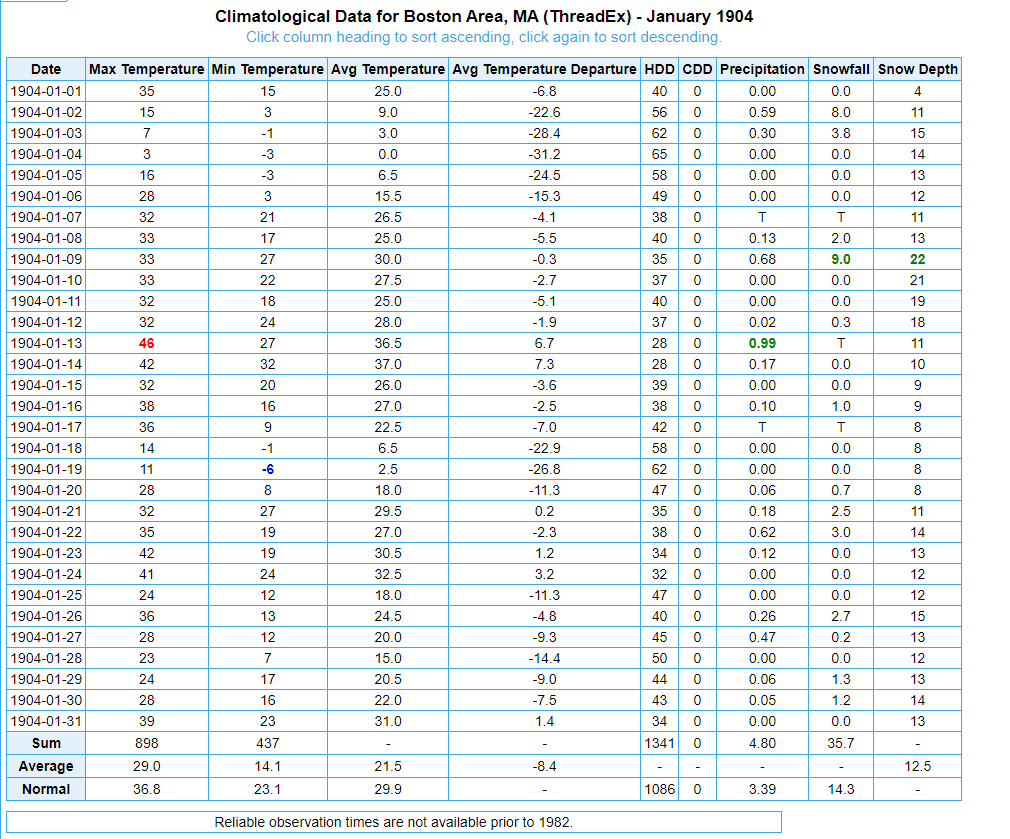
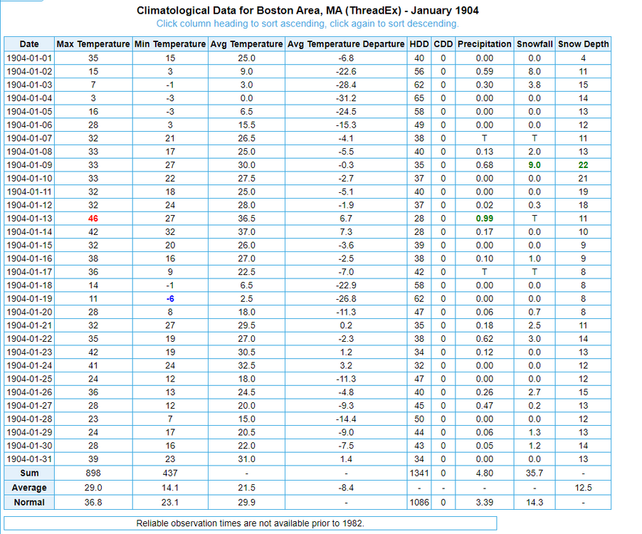
New England Winter 2024-25 Bantering, Whining, and Sobbing Thread
TheClimateChanger replied to klw's topic in New England
Boston, Massachusetts in the same month: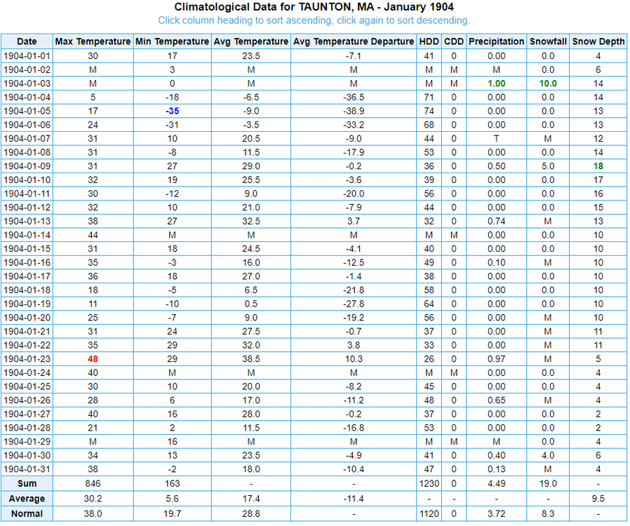
-
New England Winter 2024-25 Bantering, Whining, and Sobbing Thread
TheClimateChanger replied to klw's topic in New England
-
Pittsburgh/Western PA Winter 2024-2025 Thread
TheClimateChanger replied to Rd9108's topic in Upstate New York/Pennsylvania
-
Pittsburgh/Western PA Winter 2024-2025 Thread
TheClimateChanger replied to Rd9108's topic in Upstate New York/Pennsylvania
Roads are awful out there. -
Apparently so, although the dry fall is making for limited water.
-
Pittsburgh/Western PA Winter 2024-2025 Thread
TheClimateChanger replied to Rd9108's topic in Upstate New York/Pennsylvania
Nice little event this morning. I measured about 1.3” on an elevated flat surface. -
Winter 2024-25 Medium/Long Range Discussion
TheClimateChanger replied to michsnowfreak's topic in Lakes/Ohio Valley
Something like this would satisfy Beavis. You know it's a good month when the cumulative low temperature is -284.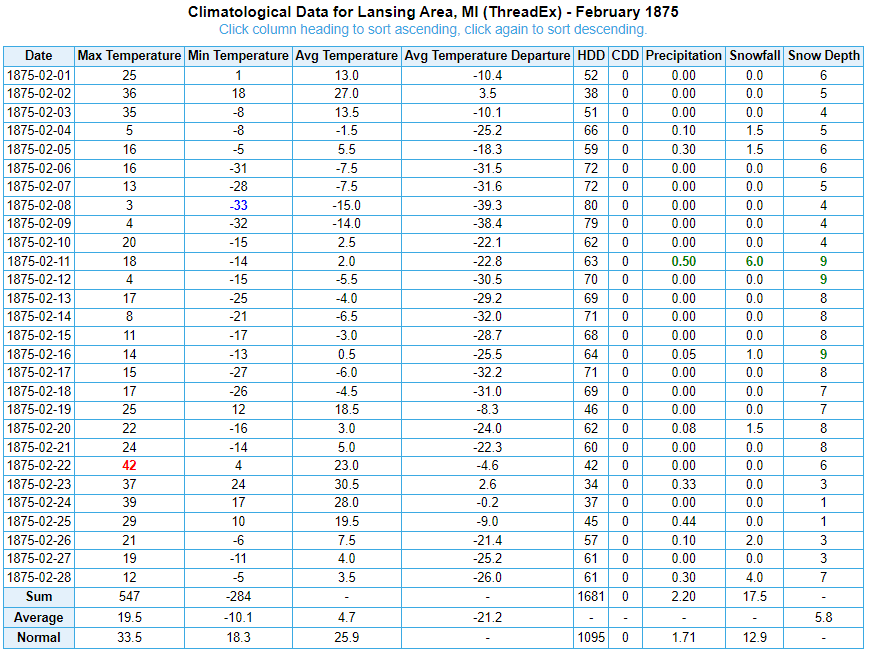
-
Winter 2024-25 Medium/Long Range Discussion
TheClimateChanger replied to michsnowfreak's topic in Lakes/Ohio Valley
You should take a look at 1995-96. You nearly had him doubled. Hell, Charleston, West Virginia had about 4x as much snow. -
Chicago Weather Records Tracking
TheClimateChanger replied to Chicago Storm's topic in Lakes/Ohio Valley
Would certainly look that way. This is computed by averaging of monthly average, so it's using the December mean to date. With the looming warmup, it might even end up somewhat above this. Rest assured, Chi-town is not alone. Pretty much everywhere is on track for a record-breaker, or certainly top 2 or 3.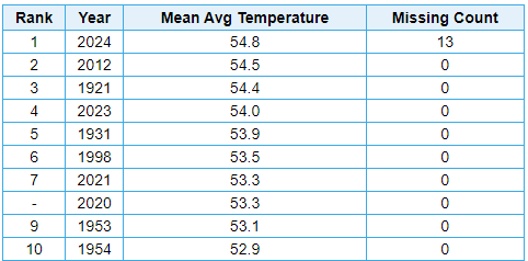
-
Winter 2024-25 Medium/Long Range Discussion
TheClimateChanger replied to michsnowfreak's topic in Lakes/Ohio Valley
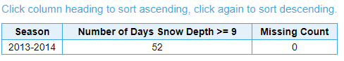
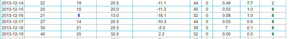
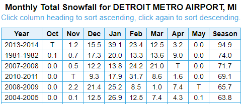
xMacis is goofy for snow depth since 2013-2014. Let's hope those are the right numbers above prior to 2012-2013. Look at this. Number of days 8"+ at DTW during 2013-2014: Number of days 9"+ at DTW: This would imply there were no days with exactly 8", but this is completely incorrect. In fact, there were five days just in December with 8" snow depth at DTW. Something's coded wrong here. You'd have to go in and manually calculate the number of days at each depth.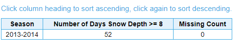
-
Winter 2024-25 Medium/Long Range Discussion
TheClimateChanger replied to michsnowfreak's topic in Lakes/Ohio Valley
Here are the top 10 SDD winters for DTW from 1959-1960 to 2012-2013, inclusive. These values are valid for DTW only, and may differ some from the threaded record prior to 1966. I wanted to maintain location consistency for this analysis. 1981-82, 528 1977-78, 514 2010-11, 494 1998-99, 391 2008-09, 382 2000-01, 333 1984-85, 309 1974-75, 297 1975-76, 285 1966-67, 277 Here are the 10 lowest SDD counts for that same time frame: 1988-89, 34 1979-80, 35 1982-83, 36 2011-12, 44 1971-72, 47 1960-61, 53 1965-66, 63 2001-02, 66 1995-96, 66 1968-69, 67 -
Winter 2024-25 Medium/Long Range Discussion
TheClimateChanger replied to michsnowfreak's topic in Lakes/Ohio Valley
I will generate the numbers for 1959-1960 to 2012-2013 in a second. Would have to do some weird stuff to figure out 2013-2014 to 2023-2024. -
Winter 2024-25 Medium/Long Range Discussion
TheClimateChanger replied to michsnowfreak's topic in Lakes/Ohio Valley
In fact, it doesn't seem to be working for any exact values other than 2 inches [and some other random depths]. It will generate number of days greater than or equal to a value, but it is having trouble with equal than. Weird. -
Winter 2024-25 Medium/Long Range Discussion
TheClimateChanger replied to michsnowfreak's topic in Lakes/Ohio Valley
I was going to do it for you, but for some reason, xMacis is messed up. If you select numbers of days where snow depth is exactly 1", it won't generate any days after the winter of 2012-13 for some reason. For DTW, that is. Not sure if this is the case for other locations. And I have no idea why it is doing it? -
Winter 2024-25 Medium/Long Range Discussion
TheClimateChanger replied to michsnowfreak's topic in Lakes/Ohio Valley
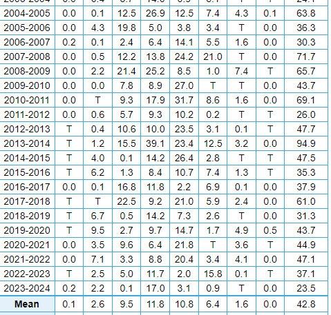
Were they really that unusual temperature-wise? Only 4 of 11 winters from 2004-2005 to 2014-15 were colder than the long-term average of 27.2 at DTW (1958-59 to 2023-24). Snowfall was certainly plentiful, however, with only 3 lower than the mean at DTW since 1959-1960. And also 5 of the top 6 amounts dating back to that timeframe (at bottom).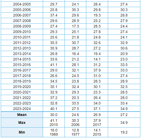
-
2024-2025 La Nina
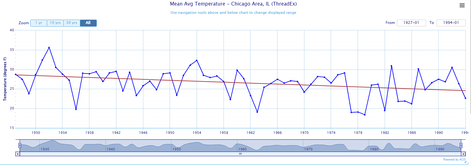
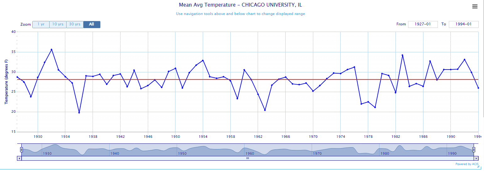
TheClimateChanger replied to George001's topic in Weather Forecasting and Discussion
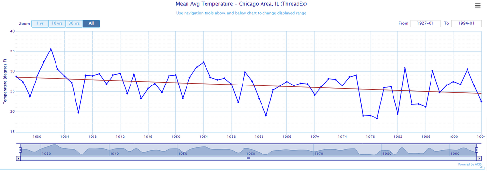
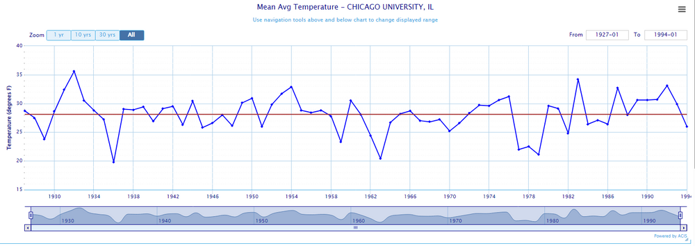
You know what they say, there are lies, there are damn lies, and then there are statistics. Here's how to manufacture a massive cooling trend from a trendless data. Move the station further and further away from the lake and present with no adjustment or even proper context. In fact, falsely claim the cooling should be even more pronounced if not for the ever-growing UHI effect. Chicago "thread" [Mean winter temps from 1926-27 to 1993-94] University of Chicago [Mean winter temps from 1926-27 to 1993-94] We can see using a fixed site (in this case, the University of Chicago), the 1960s and 1970s were somewhat colder than the preceding decades, but not to the extent shown on the threaded record. By the 1980s and early 1990s, temperatures had recovered and were already exceeding many of the past decades. Overall, a flat trend over that interval with a cyclical cooling and warming superimposed on the trend. Much more in line with the NOAA values for Cook County.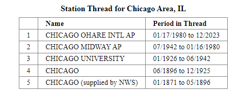
-
Pittsburgh/Western PA Winter 2024-2025 Thread
TheClimateChanger replied to Rd9108's topic in Upstate New York/Pennsylvania
I was updating the post from last week. -
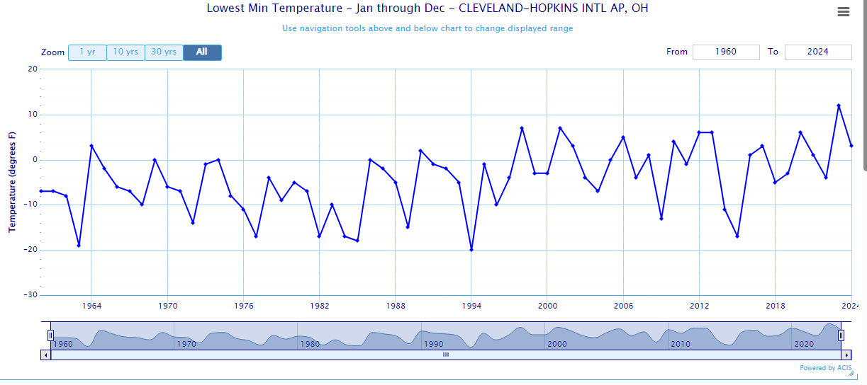
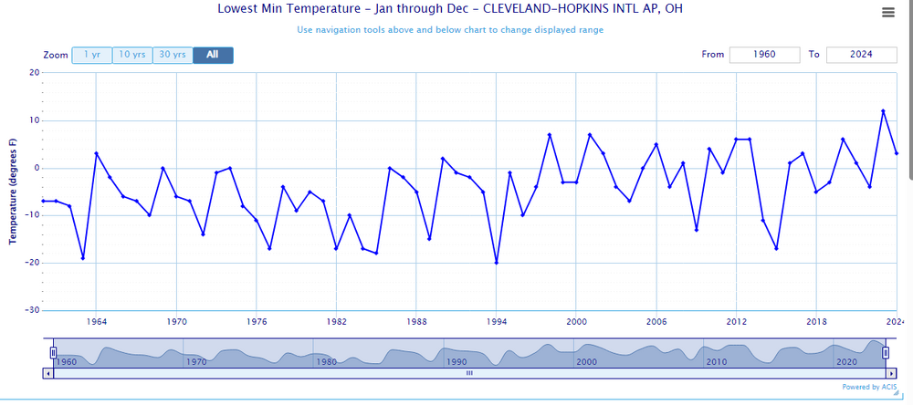
I will acknowledge you can see that 2015 anomaly on this graphic as well that @Typhoon Tip mentioned. Not really sure what was going on there. It was like mother nature was trying to fight back or something but failed.
-
And anyone saying I'm being alarmist, look at the data yourself. For the first 30 years of this dataset, there is only one zone 7 year (1964), with a few others right at 0 [cusp of 6/7]. 6 of the last nine years have been zone 7, with one of those being zone 8 conditions. What used to be exceptionally rare, is now the norm and characteristic of the climate of Cleveland. All I'm doing is extrapolating the trend, which I find to also be consistent with my understanding of prior similar climate regimes.
-
This has always been my premise. When you look at similar ancient climate regimes with large inland bodies of water, you always find very warm subtropical flora and fauna well up into the mid and high latitudes. If you look at Cleveland, you can see traditionally it was zone 5 to cold zone 6, but now is firmly zone 7. 2023 was the first year [since 1960] with Zone 8 conditions. I don't put a whole lot of stock in the pre-1960 numbers due to a variety of reasons. Moving forward with these trends, it's reasonable to expect Zone 8 conditions to fully envelope this region by the latter half of this century. If warming continues, zones 9 to 10 look likely for next century. I've never seen a valid rebuttal to this. Only, oh shut up, Cleveland won't look like Miami. You are trolling.