TheClimateChanger
-
Posts
4,598 -
Joined
-
Last visited
Content Type
Profiles
Blogs
Forums
American Weather
Media Demo
Store
Gallery
Everything posted by TheClimateChanger
-
Central PA Winter 2024/2025
TheClimateChanger replied to Voyager's topic in Upstate New York/Pennsylvania
Hype? I’m correcting a comment from earlier that appears to be claiming greenhouse gases make the sun’s rays stronger? -
Central PA Winter 2024/2025
TheClimateChanger replied to Voyager's topic in Upstate New York/Pennsylvania
That’s not how greenhouse gases work. They absorb long wave radiation. They don’t amplify solar irradiance. -
Central PA Winter 2024/2025
TheClimateChanger replied to Voyager's topic in Upstate New York/Pennsylvania
And yet this is the coldest winter in years. The last solar maximum (2014) was bookended by some of the coldest winters in decades (2013-14 & 2014-15), the likes of which haven’t been seen since. -
Pittsburgh/Western PA Winter 2024-2025 Thread
TheClimateChanger replied to Rd9108's topic in Upstate New York/Pennsylvania
-
Pittsburgh/Western PA Winter 2024-2025 Thread
TheClimateChanger replied to Rd9108's topic in Upstate New York/Pennsylvania
Some ground confirmation of heavy snow showers: -
Pittsburgh/Western PA Winter 2024-2025 Thread
TheClimateChanger replied to Rd9108's topic in Upstate New York/Pennsylvania
Looks like some heavier snow showers moving into eastern Ohio, per radar. Will be interesting to see if these hold together. Could pick up another inch or so. -
Pittsburgh/Western PA Winter 2024-2025 Thread
TheClimateChanger replied to Rd9108's topic in Upstate New York/Pennsylvania
Is it just me or do we get way more snow than they say? My flat picnic table in the backyard clearly has over a foot of snow on it, but they say only a foot has fallen all month? So nothing has melted, sublimated or blown off the table in two weeks? -
Pittsburgh/Western PA Winter 2024-2025 Thread
TheClimateChanger replied to Rd9108's topic in Upstate New York/Pennsylvania
The most recent GFS run suggests around an inch of snow on Saturday, with temperatures no higher than the mid 30s. 10:1 ratio even higher, but probably unrealistic given thermal conditions. -
Pittsburgh/Western PA Winter 2024-2025 Thread
TheClimateChanger replied to Rd9108's topic in Upstate New York/Pennsylvania
While snowfall to date is right around normal (see below) at PIT, we have already eclipsed last winter's total of 16.3 inches and are sitting just 1 inch shy of the 17.6" total from the winter of 2022-23. We will likely eclipse that winter on Thursday.
-
Pittsburgh/Western PA Winter 2024-2025 Thread
TheClimateChanger replied to Rd9108's topic in Upstate New York/Pennsylvania
Still here. Been busy with work, traveling, kids and watching football. For context, 2024 was the warmest year on record by a full degree - including downtown observations. January has been cold so far, but its only 25th coldest on record. A bit of a difference comparing a cold two-week period versus beating a 12-month annual record by an entire degree. With the cold next week, no doubt we will climb up the list and perhaps make it into the top 10 or 15 coldest starts to January. But there is still more than half the month left. And for further context, meteorological winter to date is about as "normal" as it gets. Tied with 3 prior years for 71st chilliest [of 151 years].
-
-
Occasional Thoughts on Climate Change
TheClimateChanger replied to donsutherland1's topic in Climate Change
-
Occasional Thoughts on Climate Change
TheClimateChanger replied to donsutherland1's topic in Climate Change
I don’t think most people can grasp how warm recent years are compared to the rest of the Holocene. Not sure how else to read this, but this would seem to imply even if global temperatures were sustained 1C below the most recent decade for an extended period, there would marked changes in glaciation and vegetation, given how much we have overshot natural variation. -
Occasional Thoughts on Climate Change
TheClimateChanger replied to donsutherland1's topic in Climate Change
Some more paleoclimate talk. Deniers have been using this to make it seem like the Altithermal was much warmer than today. Of course, that’s not true. These alpine forests formed over thousands of years with relatively warm global temperatures driven mostly by the Milankovitch cycles. Certainly interesting that this forest has been hidden by glaciers for 6000+ years. I would surmise that they must have remained locked in ice even during the multiple centuries long Roman and Medieval warm periods. Obviously disingenuous to use this as evidence it was warmer during the Altithermal, when it’s one point on the globe and you are comparing a millennial scale warming versus the unprecedentedly rapid warming since the Industrial Revolution coming out of a relatively colder period. -
Another way to visualize 2024, courtesy of the WMO.
-
Let’s talk winter!! Ohio and surrounding states!! 24'-25'
TheClimateChanger replied to buckeye's topic in Lakes/Ohio Valley
What a game there for THE Ohio State University. Unreal. -
-
-
Central PA Winter 2024/2025
TheClimateChanger replied to Voyager's topic in Upstate New York/Pennsylvania
They got some good pressure on that last one, that’s for sure. -
Central PA Winter 2024/2025
TheClimateChanger replied to Voyager's topic in Upstate New York/Pennsylvania
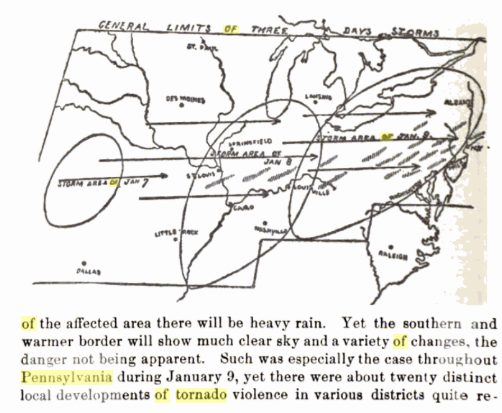
Cross post on the deadly tornados of January 9, 1889, that struck Pittsburgh and Reading. The exact death toll is hard to determine, looks like estimates from Reading ranged from 17 to 60+, and at Pittsburgh from 7 to 14+. Tornado damage was also reported in York, Carlisle, Sunbury and Williamsport, in Pennsylvania, and elsewhere across the state and region from Ohio to Brooklyn, New York, where a strong tornado struck in the evening. In all, about 20 distinct tornadic circulations were uncovered during the outbreak, which is probably an undercount given the lack of satellite and aerial imagery and low population density. A suspension bridge at Niagara Falls was also toppled, but apparently due to straight line winds gusting to near hurricane force. The worst disasters were in downtown Pittsburgh, where a building under construction on Diamond Street was toppled by the winds, killing and injuring numerous construction workers, and in Reading, where the Grimshaw Silk Mill was destroyed by the storm. 250+ people, mostly young women and girls, were working there at the time. As I note, this serves as a stark reminder that tornados can and do form at any time of the year in this part of the world. Here is a photograph of the carnage at the Grimshaw Silk Mill site following the disaster of January 9, 1889: -
I was doing some research and discovered a tornado outbreak on this date in 1889. A tornado struck downtown Pittsburgh around noon, destroying a building under construction and killing 14. Later in the day, a tornado struck Reading, Pennsylvania, destroying a textile mill, killing 33 people. A tornado struck Brooklyn, New York, causing extensive damage, particularly to the Naval Yard. Tornado damage was also reported in York, Williamsport, Carlisle, and Sunbury, Pennsylvania. It appears at least 20 distinct tornadic circulations struck Pennsylvania. Additionally, the suspension bridge at Niagara Falls was felled by the winds, although I have not found evidence of this being attributed to a tornado. Based on the description, this would rival, if not exceed, the outbreak of May 31, 1985. A stark reminder that tornados can and do hit at any time of the year in this part of the world. Looking at observations from the day, high temperatures ranged from the upper 40s to mid 50s in the affected regions. With January heat waves increasingly seeing temperatures reach the 60s and even 70s in the Mid Atlantic (I believe there was a recent case where Washington, DC nearly hit 80F!), it would be interesting to see what kind of damaging tornados could be spawned with the right atmospheric ingredients.
-
Yeah, that's probably the closest analog - although it's much warmer now IMO. Both 1990 & 1991, at the time were considered very warm, but 2024 beat them by 2+ degrees at PIT airport. I was doing some research, and was reading an article published in the Pittsburgh Post Gazette in early March 1993, talking about how it was just a normal winter, but felt much worse due to the prior several being milder and less snowy than normal. Of course, less than two weeks later, the Superstorm would hit, and coupled with other snowfall that month, would send the final seasonal total to one of the higher amounts on record. Maybe we just need another volcanic eruption like Pinatubo to give us a bit of help in our bleak climate state. About solar maximum. Curiously, I was reading "Climate Through the Ages" by C. E. P. Brooks (1926), and it's amazing how much our knowledge has improved. Believe it or not, but, at that time, high solar activity was believed to be correlated to colder weather, ostensibly by depletion of stratospheric ozone [a potent greenhouse gas] outweighing the small increase in irradiation. They did not believe carbon dioxide had a large impact on climate, due to Angstrom's experimentation, which suggested it largely absorbed radiation at wavelengths that were already saturated by water vapor absorption. Of course, that experiment was in a vacuum tube, and not representative of the earth's atmosphere. That myth still gets trotted out time to time from so-called contrarians.
-
Here's what the most recent full run of the GFS is suggesting over the next 15 days. Will be interesting to see how accurate (or inaccurate) this is.
-
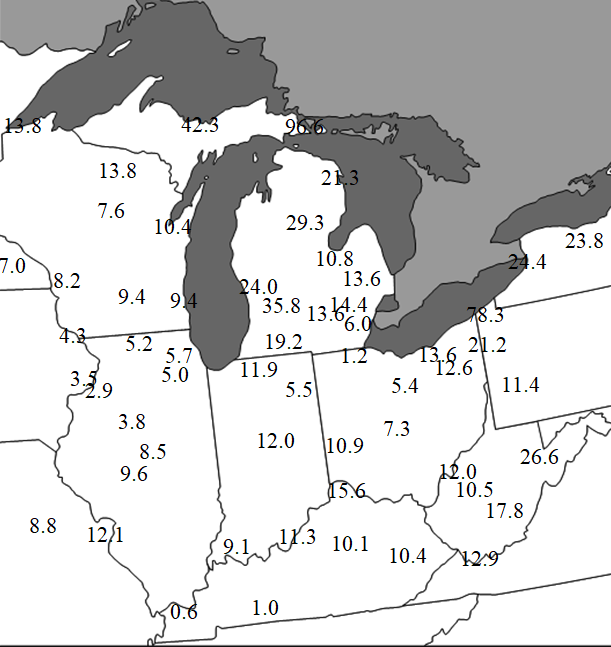
I compiled a regional map of all snowfall totals from each airport that provides snowfall measurements [or in a couple of cases, NWS office sites] through yesterday:
-
Let’s talk winter!! Ohio and surrounding states!! 24'-25'
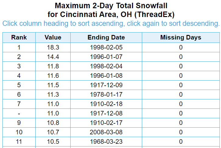
TheClimateChanger replied to buckeye's topic in Lakes/Ohio Valley
10 years, eh? Removing duplicated storm dates, this was the seventh largest two-day storm on record for the Queen City dating back to the late 19th century. This was the largest storm since 2008, and that one edged this by the smallest of margins (0.1"). There have been only 2 storms on record that produced more than 1" more than this event over a 2-day period (1996 & 1998). From 1917-1978, there were no storms that produced more snowfall than this in any 2-day period. You may never see this again in your lifetime. Hell, with the warming client and already marginal subtropical climate of Cincinnati, this very well could be the heaviest storm for perpetuity.