TheClimateChanger
-
Posts
3,066 -
Joined
-
Last visited
Content Type
Profiles
Blogs
Forums
American Weather
Media Demo
Store
Gallery
Everything posted by TheClimateChanger
-
Pittsburgh, Pa Summer 2024 Thread.
TheClimateChanger replied to meatwad's topic in Upstate New York/Pennsylvania
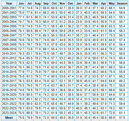
Also, despite the recent cooldown, still in 8th place overall in the threaded record in terms of summer temps to date with only 2 warmer years since 1901 (1934 & 1949). Given the forecast for the next week or so, we will be dropping in these rankings. Pretty much a done deal - barring incredible heat at the end of the month - that we will finish below 1995, and probably even 2016. Edit: Actually looking at yesterday's 8-14 day outlook, CPC gives us slightly elevated odds for below normal continuing right into week 2 [August 22-28]. I do suspect we'll see at least one more heat wave at the tail end of August or in September.
-
Pittsburgh, Pa Summer 2024 Thread.
TheClimateChanger replied to meatwad's topic in Upstate New York/Pennsylvania
The iPhone weather app would suggest we approach 70 for a high for a few days early next week. Doubt we get there though, as the NWS forecast is generally more moderate with mid 70s, which seems reasonable with the sunshine on Tuesday & Wednesday, and warm/muggy start on Monday. Otherwise, wildfire smoke has created more haze than I would have thought the last couple days. Didn't look too impressive on modeling but it's been hanging low in the atmosphere. Seems thicker up in New England. -
It's funny. I don't see all the "it's just summer" commenters on X chiming in like you would see in response to a forecast of +10 for several days. When it's 2 or 3 degrees below normal [and that's with the highest normals which have been jacked up ~2F in the past 30 years] for a handful of days, isn't it literally just summer?
- 1,764 replies
-
- 1
-

-
- hurricanes
- tropics
- (and 5 more)
-
Pittsburgh, Pa Summer 2024 Thread.
TheClimateChanger replied to meatwad's topic in Upstate New York/Pennsylvania
-
Central Pa. Summer 2024
TheClimateChanger replied to mahantango#1's topic in Upstate New York/Pennsylvania
Oh no, it's oh so cold! I guess climate change really is a hoax! Wake me up when most of southwest Pennsylvania is at or below freezing... Even the heat island at the PIT airport is in the 30s, and outlying areas have mean monthly lows in the 40s. Because this is what actual cold weather in August looks like. It looks like 1982.
-
No, you're right. Just look at places where it used to radiate, like the northern Pennsylvania mountains. Bradford Airport, 2100' elevation, nestled between the Allegheny National Forest and Pennsylvania State Gamelands, was 52F yesterday for the low. Fully 22 of 42 years from 1957-2000 [no data for 1995 & 1996] had a mean August monthly low temperature below 52F, and two others within 0.5F [so more or less 52F]. 51-52F used to be a typical August low in this location, with cold August mornings dropping into the 20s and 30s. Now, our so-called cold airmasses can't even do 50F there.
-
Between this and the 6 inches of snow and slush on that Lake Michigan ship two days prior, sounds like 1882 would have been an exciting time for a weather weenie.
- 1,764 replies
-
- 1
-
-
- hurricanes
- tropics
- (and 5 more)
-
Pittsburgh, Pa Summer 2024 Thread.
TheClimateChanger replied to meatwad's topic in Upstate New York/Pennsylvania
-
2024 Short/Medium Range Severe Weather Discussion
TheClimateChanger replied to Chicago Storm's topic in Lakes/Ohio Valley
The high resolution, short term modeling did a good job with depicting that stationary band of thunderstorms over north central Ohio associated with the cold front and interaction with PTC Debby’s cyclonic flow. Radar estimates up to 5-6” in spots. -
Occasional Thoughts on Climate Change
TheClimateChanger replied to donsutherland1's topic in Climate Change
I feel like when these people make these ludicrous claims [i.e., they are manipulating recent temperatures upward], they forget the US has had an independent, parallel network of high quality stations for two decades now. -
Occasional Thoughts on Climate Change
TheClimateChanger replied to donsutherland1's topic in Climate Change
Anyways, anyone with half a brain knows recent years have been warm. Why would they be manipulating the data by adding to it? Moreover, NCEI and NOAA generate their anomalies from the nClimDiv dataset with way more stations, not USHCN. There is also a parallel network known as the Climate Reference Network (CRN) which has been operational since 2005. CRN sites are carefully monitored, mostly rural locations, with highly accurate equipment and quality control. The skeptics were the ones who lauded this effort. The recent trends from nClimDiv, USHCN and the raw and undadjusted U.S. CRN data are nearly identical. In fact, CRN has a slightly greater positive trend in the period 2005-2024. We can see this from May, himself, who created this graphic in 2020. Since that time, USCRN has continued to warm slightly faster than nClimDiv and USHCN. So obviously the homogenization and infilling are not creating spurious warming. If anything, those datasets have a slight cooling bias still. Comparing USCRN and nClimDiv to USCHN – Andy May Petrophysicist -
Occasional Thoughts on Climate Change
TheClimateChanger replied to donsutherland1's topic in Climate Change
I don't think he shares his sources... probably something Heller cooked up. Anyways, it piqued my curiosity enough to look into. I came across this "petrophysicist" who I would characterize as somewhat of a more cerebral skeptic than Heller. His conclusions are clearly wrong, but at least he provides context to determine what is being shown in this graphic. @chubbscan correct me if I'm misinterpreting this. Recent USHCN Final v Raw Temperature differences – Andy May Petrophysicist This image appears similar to the one presented above: According to Mays, this shows the difference between the mean of the raw data and the mean of the final data by year. The orange trace shows the number of stations over time with raw data. Many stations with missing data are estimated using pair-wise homogenization. If you look only at stations with raw data, the graphic is much different. There is substantially less difference in recent years from ~0 to ~0.2C [ending in 2020]. This purports to show the difference between the final average of all data [including estimated data] and the average of the station data for which actual raw data is available. I think you can see the problem with this - if the stations where the estimated data is from locations where the mean temperature is generally warmer than the US average, then it's going to look like there's some big discrepancy. And that appears to be what's going on. May appears to anticipate this argument, implicitly, by claiming the stations dropped off are widely scattered. Although he does acknowledge Oklahoma appears to have a disproportionate number. Looking at this, yes, Oklahoma and the Delmarva region appear to have the most station dropoff [assuming this is accurate]. Oklahoma has a yearly mean of nearly 60F. The Delmarva is like 54-55F. The national average is 52F. In order to accurately gauge the impact of infilling, you would need to compare it to the trend generated only from the stations with raw data for the entire period. Mays never does this step. Instead, he just concludes without evidence that is causing a massive warming trend. -
Occasional Thoughts on Climate Change
TheClimateChanger replied to donsutherland1's topic in Climate Change
Thank you for the update. I saw mention of the flash flood warning for that on my X (formerly Twitter) feed this morning, but wasn't sure if it was unusual or something that happens frequently there. Has this ever occurred before? -
Pittsburgh, Pa Summer 2024 Thread.
TheClimateChanger replied to meatwad's topic in Upstate New York/Pennsylvania
Will be interesting to see whether the NAM 12k or 3k performs better? Or if they are both out to the proverbial sea. The 3K brings over 5" of rain to parts of eastern Ohio, while the 12K has minimal rain there. 3K 12K -
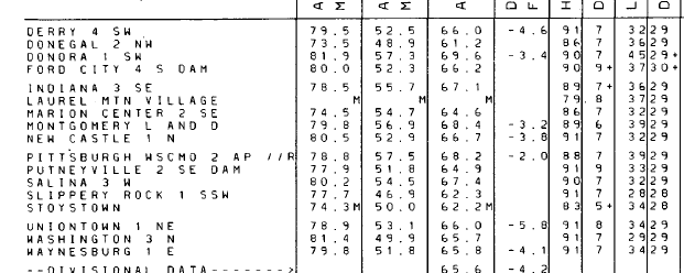
The 5-minute obs could be rounded up or down depending on the temperature reported. A 5-minute ob of 91 means the rounded Celsius value was 33C, which means the actual value could be between 32.5 and 33.4C. An actual max temperature between 32.5-33C would all result in a rounded high of 91F, while a temperature of 33.1C to 33.4C would result in a high of 92F. An observation of 90F (i.e. 32C) is the opposite - it can be either 89F or 90F, depending on the exact reading in Celsius.
-
2024 Short/Medium Range Severe Weather Discussion
TheClimateChanger replied to Chicago Storm's topic in Lakes/Ohio Valley
-
Pittsburgh, Pa Summer 2024 Thread.
TheClimateChanger replied to meatwad's topic in Upstate New York/Pennsylvania
Up to 3.5” of rain on the day IMBY. Currently raining at a rate of about 2” per hour. -
2024 Short/Medium Range Severe Weather Discussion
TheClimateChanger replied to Chicago Storm's topic in Lakes/Ohio Valley
79 mph wind gust at Burke Lakefront Airport in Cleveland. -
Pittsburgh, Pa Summer 2024 Thread.
TheClimateChanger replied to meatwad's topic in Upstate New York/Pennsylvania
Pushing 3” at my home gauge. Wow. -
Pittsburgh, Pa Summer 2024 Thread.
TheClimateChanger replied to meatwad's topic in Upstate New York/Pennsylvania
Made it up to 91F just ahead of the line of approaching thunderstorms. -
Pittsburgh, Pa Summer 2024 Thread.
TheClimateChanger replied to meatwad's topic in Upstate New York/Pennsylvania
I think I may be the only one still keeping track, but yesterday was indeed the 18th 90+ reading of the year. First to top off at exactly 90F. Has reached 89F so far today, which typically would probably guarantee a 90F or better high temperature, but clouds are quickly on the increase with showers and thunderstorms to the north. Clearly, I was wrong when I indicated last week might be the last chance for awhile. But, at this point, the only day with any chance of 90F for the foreseeable future [after today] is Thursday. At this point, mid to upper 80s looks like the better bet. Debby's remnants move north into Pennsylvania on Friday, cooling things off, and helping to pull down a cooler and drier airmass in its wake. -
Pittsburgh, Pa Summer 2024 Thread.
TheClimateChanger replied to meatwad's topic in Upstate New York/Pennsylvania
Interesting. Hopefully, the NAM is off its rocker. Could definitely do without over 4" of rain in 12 hours from the remnants of Debby. -
Central Pa. Summer 2024
TheClimateChanger replied to mahantango#1's topic in Upstate New York/Pennsylvania
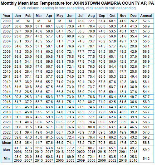
Clearfield Lawrence AP (1516' elev.) Dubois Jefferson AP (elev. 1804') That's 1.6F difference over less than 300 feet. So my estimate is based on actual data. I guess I need to go to flight school to learn how the actual data is wrong.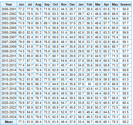
-
Central Pa. Summer 2024
TheClimateChanger replied to mahantango#1's topic in Upstate New York/Pennsylvania
So yeah, I said what I said and I believe it to be accurate. -
Central Pa. Summer 2024
TheClimateChanger replied to mahantango#1's topic in Upstate New York/Pennsylvania
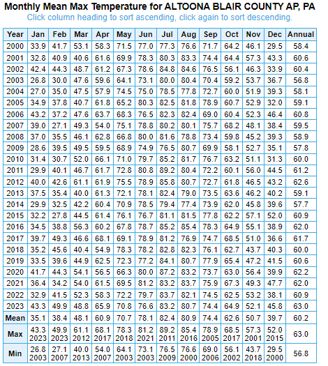
Pick any two sites that are nearby are you'll see the actual difference is greater than 4F per 1000 feet. Here's 3.4F difference on 800' elevation gain. You say you need 1,000 feet of gain for this change. Actually, you claimed even less in a humid climate like Pennsylvania. Cambria County Airport (2274') Altoona Airport (1467')