TheClimateChanger
-
Posts
3,060 -
Joined
-
Last visited
Content Type
Profiles
Blogs
Forums
American Weather
Media Demo
Store
Gallery
Everything posted by TheClimateChanger
-
Blowvember - and not named for wind potential
TheClimateChanger replied to Go Kart Mozart's topic in New England
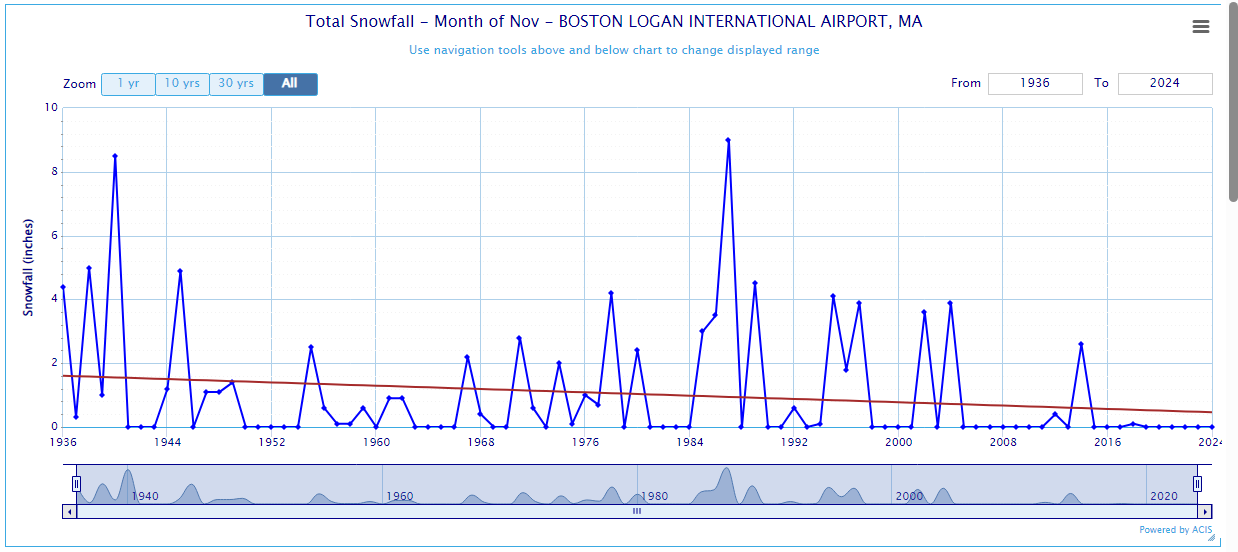
Your neck of the woods looks similar, although I can kind of see what you mean. There was a bit of resurgence in the 1980s and 1990s, but less than the 1930s and 1940s at Logan. It's only in the last 15 years or so where it's always a shutout.

-
Blowvember - and not named for wind potential
TheClimateChanger replied to Go Kart Mozart's topic in New England
I don't know about that Tip. Looks like Novie used to serve up way more cryo events in the distant past. 1950, of course, was the grandaddy of them all.
-
Pittsburgh, PA Fall 2024 Thread
TheClimateChanger replied to TheClimateChanger's topic in Upstate New York/Pennsylvania
More pictures from the Youghiogeny River Lake. -
Central PA Autumn 2024
TheClimateChanger replied to Itstrainingtime's topic in Upstate New York/Pennsylvania
Low rivers and streams in western Penna too. That bridge is typically submerged by the reservoir. -
Mostly a myth. The Gulf Stream is not a significant factor in the climate of Western Europe. Europe has a mild climate because it is an oceanic climate, and atmospheric wave trains (dictated largely by topography and continental location). The same phenomenon is noted on the west coast of North America where cold currents are present. There would probably be a modest cooling more than offset by radiative warming. In any event, it is unlikely to come to a halt anytime soon. I think some people like to talk about this because they think it might save winter. Sorry not happening. An AMOC slowdown is just going to concentrate even more heat off the coast of eastern North America, and lead to even more warming. https://ocp.ldeo.columbia.edu/res/div/ocp/gs/#:~:text=The Gulf Stream Myth&text=A few times a year,coming years or even stop. https://www.americanscientist.org/article/the-source-of-europes-mild-climate https://www.whoi.edu/oceanus/feature/will-the-gulf-stream-really-shut-down/
-
Fortunately, we won't need to warm 5F per decade to reach Floridian levels in New York. If we look at Tallahassee, we can see the average from 1957-58 to 1987-88 was 51.9F, so about a degree a decade for the next 13 decades should do for NYC. That would put the Big Apple at Floridian levels by the middle of next century. But that doesn't tell the whole story. By minimum temperature, the last 9 winters have only averaged about 7F cooler than Tallahassee in the mid to late 20th century. Since vegetation is largely affected by minimum temperatures [and cold extremes], I would anticipate that to change more rapidly than might be implied by a mean temperature analysis.
-
Occasional Thoughts on Climate Change
TheClimateChanger replied to donsutherland1's topic in Climate Change
PRISM had this as 3rd warmest and 3rd driest on record for the CONUS (tip of the hat to Brian Brettschneider on X). I suspect it would have been the driest if not for the rainfall in the central US over the last 24 hours or so of the month [i.e., if October only had 30 days]. Also, the 3rd warmest was by average mean temperature. Bucking recent trends, maximum temperatures were significantly warmer than minimum temperatures across the CONUS. So it very well may have been the warmest by average maximum temperature. He did not break down the PRISM temperatures by maximum and minimum, so we'll have to wait until NCEI releases its data [usually around the 11th of the month] for those figures. -
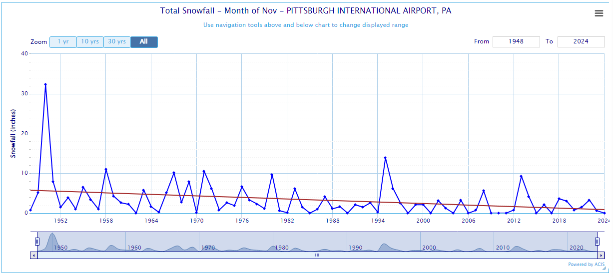
@BigJoeBastardi on X was recently discussing 1950 as a potential analog. I personally don't think it is a good analog. 1950 was a very cold year for the CONUS as a whole. Indeed, it had been the coldest year in the CONUS since 1929, although it was surpassed by the following year (1951). And it's only been surpassed by a handful of years since, and of course nothing even close in recent decades. I do wonder if the massive Chinchaga firestorm had something to do with the chill. The intensity of that fire could have easily lofted aerosols into the stratosphere, as we've seen with some recent fires. The winter of 1950-51 remains the snowiest on record at Pittsburgh.
-
-
2024-2025 La Nina
TheClimateChanger replied to George001's topic in Weather Forecasting and Discussion
You can see the impact of that rain event here. Many areas were on track for one of the driest months on record, but wound up just a bit below normal. -
2024-2025 La Nina
TheClimateChanger replied to George001's topic in Weather Forecasting and Discussion
Also third driest on record. I suspect it would have been the driest on record (possibly of any month) up until the last 24 hours when many areas in the middle of the country picked up 1-2” of rain. -
Central PA Autumn 2024
TheClimateChanger replied to Itstrainingtime's topic in Upstate New York/Pennsylvania
At this rate, we're going to be wishing each other "mele kalikimaka" in our Hawaiian shirts and shorts, sipping margarita out a coconut. -
2024-2025 La Nina
TheClimateChanger replied to George001's topic in Weather Forecasting and Discussion
One thing I'll say is I think the drought is artificially cooling these numbers. You can see around Pittsburgh, it was an absolute blow torch with high temperatures more than 6F above normal. But the overall ranking is unimpressive, because low temperatures were so much colder. I suspect this was the case in a lot of places. I do wonder what an analysis of maximum temperatures only would show. -
2024-2025 La Nina
TheClimateChanger replied to George001's topic in Weather Forecasting and Discussion
Only 3rd warmest? Even Tony Heller's fraudulent analysis has this October as 2nd warmest. As you can see, his analysis shows a cooling trend when, in fact, there's been a sharp warming trend in the actual data. So if he has this as 2nd warmest, surely it must be the warmest on record by a long shot. -
Ok, weird how much hotter Purcellville & Staunton were then everywhere else.
-
Central PA Autumn 2024
TheClimateChanger replied to Itstrainingtime's topic in Upstate New York/Pennsylvania
As user @Dark Starnoted in the NY & NJ forum:
-
November 2024 General Discussion
TheClimateChanger replied to SchaumburgStormer's topic in Lakes/Ohio Valley
At Columbus, October 2024 was the 8th driest month on record [6th driest October]. Was just 0.02" above 5th place [3rd for October]. It was the driest of any month in 61 years. The period from June 1 continues to run as 2nd driest on record behind only 1930.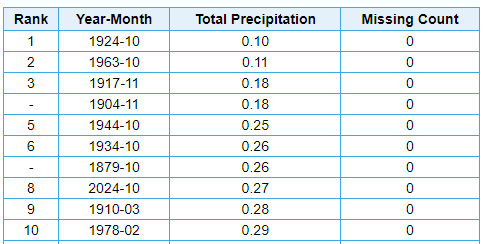

-
November 2024 General Discussion
TheClimateChanger replied to SchaumburgStormer's topic in Lakes/Ohio Valley
In the last 3 months, Zanesville, Ohio had its 5th and 7th [which would have been 6th prior to August] driest months on record. Will be interesting to see what November holds. Interestingly, although perhaps not too surprisingly, despite being 7th driest of any month, October 2024 was only 4th driest October on record. August 2024 was the driest of any month since October 1924, and only August 2024 and October 1963 were drier than October 2024 since that date.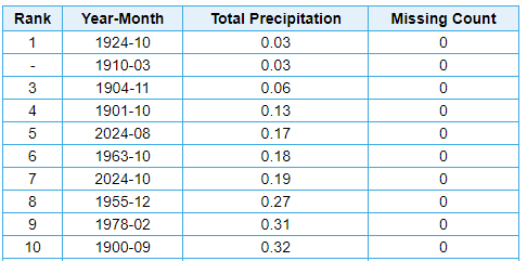
-
Summer-Fall 2024 Weather Disco Med/Long Range
TheClimateChanger replied to John1122's topic in Tennessee Valley
It certainly looks like winter is on the wane for east Tennessee.
- 689 replies
-
- 2
-

-

-
- heat
- thunderstorms
- (and 7 more)
-
Wow, weird how much hotter it was in Staunton than everywhere else in 1919!
-
Pittsburgh, PA Fall 2024 Thread
TheClimateChanger replied to TheClimateChanger's topic in Upstate New York/Pennsylvania
-
Central PA Autumn 2024
TheClimateChanger replied to Itstrainingtime's topic in Upstate New York/Pennsylvania
You can keep saying it but you're wrong. The 2:56 pm observation is a METAR report, not a raw 5-minute report [which are reported every five minutes beginning at the top of the hour]. The raw readings are based on the temperature rounded to the nearest degree Celsius, and then converted to Fahrenheit, which is why they can vary +/- 1F from what is reported. METAR observations, on the other hand, report the temperature to the nearest decimal degree Celsius. In this case, the actual [non-rounded] temperature is 27.8C, which converts to 82F. If you still want to persist in your folly, I will bet you $1,000,000 that the high for the day at MDT is at least 82F.
-
Central PA Autumn 2024
TheClimateChanger replied to Itstrainingtime's topic in Upstate New York/Pennsylvania
The 82F is from the 2:56 p.m. METAR report, which isn't rounded. -
Central PA Autumn 2024
TheClimateChanger replied to Itstrainingtime's topic in Upstate New York/Pennsylvania
It's at least hit 82F. That's the actual METAR temp, not a rounded, raw output from the ASOS. -
Fall/Winter '24 Banter and Complaints Go Here
TheClimateChanger replied to IWXwx's topic in Lakes/Ohio Valley
Well, then, you should stay in your own lane. I literally posted actual data proving my statement was not outlandish. In fact, if you review the table, the 12-month running average at Pittsburgh is not only warmer than the late 20th century 30-year mean at Tri-Cities Airport in Tennessee, it's only slightly cooler than the warmest year observed there in those 30 years. For context, the elevations of these sites are approximately: TRI - 1500' ASL PIT - 1200' ASL BNA - 600' ASL SDF - 500' ASL If you want to compare BNA and SDF, then you should use data from the city of Pittsburgh. Unfortunately, it hasn't been collected since 1979. I can tell you it averaged 2.6F warmer than the readings at PIT airport [with every overlapping year falling between 1.1 & 3.8F warmer]. I'll let you do that math there to figure out approximately what the temperatures have been like in the City.