TheClimateChanger
-
Posts
3,060 -
Joined
-
Last visited
Content Type
Profiles
Blogs
Forums
American Weather
Media Demo
Store
Gallery
Everything posted by TheClimateChanger
-
Fall 2024 Medium/Long Range Discussion
TheClimateChanger replied to madwx's topic in Lakes/Ohio Valley
The map is for meteorological winter (December - February). -
Pittsburgh, PA Fall 2024 Thread
TheClimateChanger replied to TheClimateChanger's topic in Upstate New York/Pennsylvania
Slight risk of heavy snow the week of 11/21. -
Fall 2024 Medium/Long Range Discussion
TheClimateChanger replied to madwx's topic in Lakes/Ohio Valley
-
Central PA Autumn 2024
TheClimateChanger replied to Itstrainingtime's topic in Upstate New York/Pennsylvania
-
Central PA Autumn 2024
TheClimateChanger replied to Itstrainingtime's topic in Upstate New York/Pennsylvania
It's starting!
-
Fall/Winter '24 Banter and Complaints Go Here
TheClimateChanger replied to IWXwx's topic in Lakes/Ohio Valley
I mean, of course, there's going to be some lake effect snow. But Buffalo's snowfall total of 71.3" was 24.1" below normal. Other locations were far worse - Erie had its 4th lowest snowfall on record (24.8") and Cleveland its 7th lowest on record (25.7") - the latter just one year removed from its 3rd least snowfall on record (22.7" in 2022-23). Both years being the lower than any winter since 1931-32. Rochester's total of 52.5" was 13th lowest on record, one year removed from its 10th least snowy winter on record (50.4" in 2022-23). Both of those totals were least since the winter of 1952-53. Doesn't matter how warm the lakes are if there isn't sufficient cold air. And northwest flow events have seemingly gone extinct in the last several years. -
Fall/Winter '24 Banter and Complaints Go Here
TheClimateChanger replied to IWXwx's topic in Lakes/Ohio Valley
They are not wrong. -
Central PA Autumn 2024
TheClimateChanger replied to Itstrainingtime's topic in Upstate New York/Pennsylvania
Incredible. 1.3" more than MDT has recorded since January 25, 2023, a period of nearly 22 months. -
Pittsburgh, PA Fall 2024 Thread
TheClimateChanger replied to TheClimateChanger's topic in Upstate New York/Pennsylvania
Through the first third of November, PIT is running a whopping 10.2F degree surplus relative to the normal. Needless to say, we are building a considerable separation between the prior warmest years in the threaded record. Now, 0.6F warmer than 1880 and 0.9F warmer than 1921. 1921 is the current warmest year at 55.4F. In 1921, there was an impressive cold snap in mid-November, then the second half of the month was largely a "blowtorch." December saw fairly typical temperatures. 1880 was bitterly cold in the second half of November and the entire month of December, so it quickly plummets in the rankings from here on out. Almost looks like a lock for warmest year on record, and we could do it by more than 1F over 1921 if December is mild.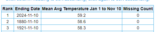
-
November 2024 General Discussion
TheClimateChanger replied to SchaumburgStormer's topic in Lakes/Ohio Valley
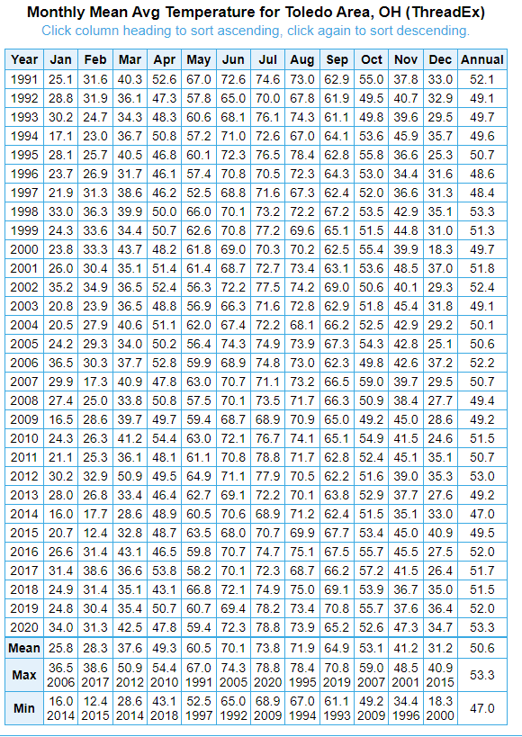
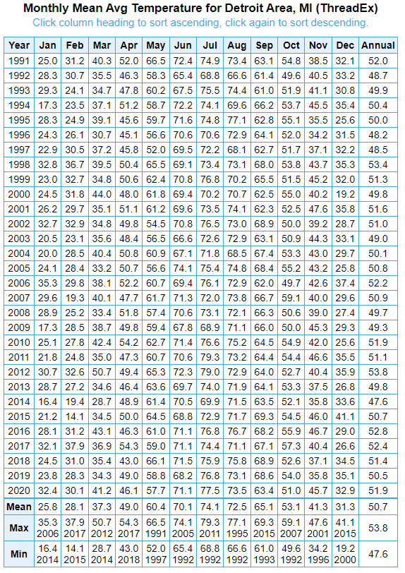
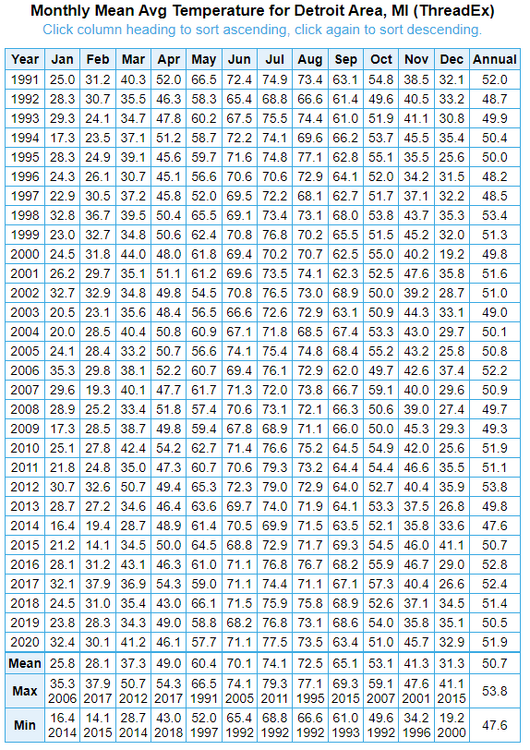
Mostly just a result of the fact that they added about 1.5F to the calculated mean for each month in the 1991-2020 normals for Toledo. The 1991-2020 mean for October is 53.1F for both Toledo and Detroit, so if they had just used the average, it would be +3.4F at Detroit and +3.1F at Toledo. If you look at the data, you'll notice a disconnect began in late 2018. What I think happened is the TOL ASOS was reporting too high during that period. While the normals are often thought of as averages, they are not. They are smoothed and normalized, but NOAA also makes adjustments based on pairwise homogenization. So I think the normals for Toledo got incorrectly adjusted upwards based on the warming in the last couple of years of the climate base period, which I believe was likely just due to a bad sensor or perhaps a problem with the fan/aspiration. The adjustments make sense if they are based on a change in equipment, change in location of the observation site, or a growing urban heat island effect, but can be unrepresentative if the changes result from an equipment problem that is corrected after the fact. In the case of TOL, the ASOS was down for much of the month of August. It's clear that since that change, it's been reporting temperatures more in line with surrounding locations.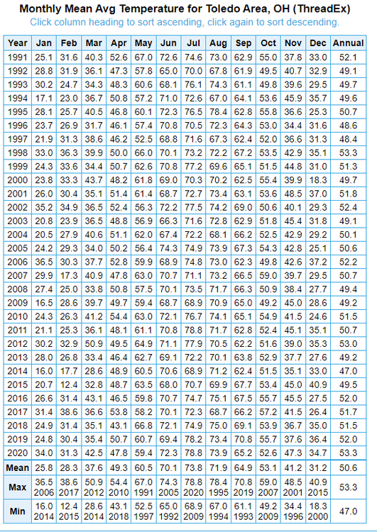
-
Central PA Autumn 2024
TheClimateChanger replied to Itstrainingtime's topic in Upstate New York/Pennsylvania
Same here. I’m out in the woods. So eerie for November, when you’d typical expect it to be like 40F at this time of night. -
Blowvember - and not named for wind potential
TheClimateChanger replied to Go Kart Mozart's topic in New England
Surprised it wasn’t even higher. It was 85F at Dunkirk, New York yesterday. That’s hot for there for anytime of the year. Nearby Buffalo has seen 4 years where the temperature didn’t even reach 85F, and 5 others where the maximum reading was 85F. Thought that superheated airmass descending over the mountains might be able to reach 90F. -
85F in Dunkirk, New York. Wow, just imagine how hot this superheated airmass in the Coastal Plain. Maybe some 90s tomorrow?
-
85F in Dunkirk, New York today, just off Lake Erie. That’s warm for July.
-
Central PA Autumn 2024
TheClimateChanger replied to Itstrainingtime's topic in Upstate New York/Pennsylvania
-
UAH in at +0.73C for October 2024. Dr. Spencer also announced a new version 6.1, which truncates data from the NOAA-19 satellite starting in 2021. This imparted a small chilling effect to recent data, which he says brought the dataset more in line with RSS and NOAA.
-
It has reached at least 86F in Huntington, West Virginia. I wonder if the coastal Mid Atlantic could see 90F tomorrow as this superheated airmass descends over the mountains?
-
November 2024 General Discussion
TheClimateChanger replied to SchaumburgStormer's topic in Lakes/Ohio Valley
Impressive numbers all across the Buckeye State. Just across the river from the far south, Huntington, West Virginia has reached at least 86F (30C). That matches a monthly record. -
November 2024 General Discussion
TheClimateChanger replied to SchaumburgStormer's topic in Lakes/Ohio Valley
Records falling all over. The 82F at Zanesville matches the November monthly high. The 80F at New Philadelphia, Ohio is the latest 80F+ on record and only the second observed in the month of November... the monthly record is 81F from November 4, 1961. -
Pittsburgh, PA Fall 2024 Thread
TheClimateChanger replied to TheClimateChanger's topic in Upstate New York/Pennsylvania
Record high of 81F today. Also matches 1948 for the latest 80F+ reading on record at Pittsburgh. -
He could be right and it still wind up as a crappy winter. 2022, which he cites as the last time this happened, has been bandied as a possible analog to this winter - and obviously that was a terribly (warm) winter overall but there was a bout of extreme cold and a bit of snow just before Christmas.
-
Central PA Autumn 2024
TheClimateChanger replied to Itstrainingtime's topic in Upstate New York/Pennsylvania
It was obviously a joke. Just commenting on the absurdity of 80F in November, which is much closer to heat advisory criteria of 100F than it is to extreme cold advisory criteria of -10F. -
Central PA Autumn 2024
TheClimateChanger replied to Itstrainingtime's topic in Upstate New York/Pennsylvania
Nearing 80 here in Pittsburgh. Unreal. At this rate, we're more apt to have a heat advisory than an extreme cold advisory this winter. -
Fall 2024 Medium/Long Range Discussion
TheClimateChanger replied to madwx's topic in Lakes/Ohio Valley
"What happens in November, the winter will remember." -
Blowvember - and not named for wind potential
TheClimateChanger replied to Go Kart Mozart's topic in New England
Lol, no I did say I saw your point in the BOS snowfall data - assuming you were referring to the time from the 1980s to early 2000s.