

TheClimateChanger
-
Posts
3,060 -
Joined
-
Last visited
Content Type
Profiles
Blogs
Forums
American Weather
Media Demo
Store
Gallery
Everything posted by TheClimateChanger
-
Pittsburgh, PA Fall 2024 Thread
TheClimateChanger replied to TheClimateChanger's topic in Upstate New York/Pennsylvania
-
2024-2025 La Nina
TheClimateChanger replied to George001's topic in Weather Forecasting and Discussion
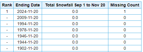
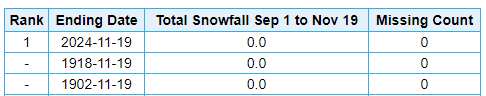
No problem, Don. Also, of note, the 22.6" officially recorded at ERI yesterday was just 2.2" shy of the entire seasonal total from last winter... which, incidentally, was the 4th lowest of record. The graphic below shows it as 6th; however, there is missing data for the winters of 1942-43 & 1943-44. If you cross-check the missing days from the climate reports using NCEI IPS, you'll see the seasonal total was over 48 inches in 1943-1944 and over 40 inches the preceding winter. The missing count for 1918-1919 & 1897-1898 appears just to correspond to months where no snow fell. No snowfall data was reported, which was interpreted as "missing" by the algorithm. And, of course, this ignores changes in snowfall measurement procedure which likely make the earlier data lower than it would otherwise be if the procedures were the same as today.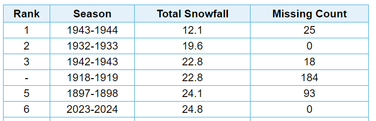
-
Nobody uses BlueSky. Garbage X knockoff app.
-
2024-2025 La Nina
TheClimateChanger replied to George001's topic in Weather Forecasting and Discussion
Highest amount [as of 7 pm yesterday] was 32.1" 2 miles ESE of North East, Pennsylvania, with another report of 30.2" from Girard, Pennsylvania shortly after 6 pm. No doubt well over three feet totals since that time.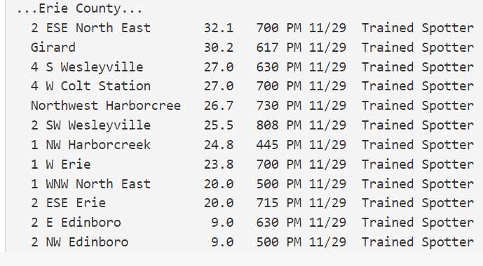
-
November 2024 General Discussion
TheClimateChanger replied to SchaumburgStormer's topic in Lakes/Ohio Valley
22.6" officially yesterday, nearly matching the total snowfall of 24.8" from last winter. In fact, with the snowfall this morning, it's probably already gone over last winter's total. Unofficially, up to 30 inches in some places in northwest Pennsylvania yesterday. -
Central PA Autumn 2024
TheClimateChanger replied to Itstrainingtime's topic in Upstate New York/Pennsylvania
Have you guys encountered this new scam in Pennsylvania? I've seen a lot of discussion on Reddit about it. I know Columbia Gas has been doing it for some time, as has Philadelphia Gas Company. Now People's Gas is doing the same. It's called "weather normalization adjustment" and they tack it onto your gas bill. In theory, it's supposed to provide more standard billing and it's marketed as "revenue neutral." But I went back and looked at my bills back to 2002, and it looks like it's always additive - sometimes quite large. Even in December 2022, when there was a huge cold snap at Christmas, they still tacked on an extra charge. It doesn't even make sense. Supposedly, it'll charge you when less gas is being used due to warm weather. But I went back and compared and some months they said were warmer and I should have used less gas, I used the same or more gas. How am I being assessed a charge because their formula says I used less gas when I actually didn't use less gas? Doesn't make sense. Normally distributed data should have an equal amount above and below. Whatever they are claiming is normal weather is clearly bogus. Looks like a cash grab for the utilities. I see PGW used this scam in May 2022, yes, in May, to charge people huge sums for a month when nobody uses gas anyways. They ended up refunding it that time. Unreal. -
True, although, in this case, with a random public report from the monument, I suspect it was measured the “old-fashioned” way by just sticking a yard stick in the snow after it stopped.
-
Modern snowfall records from the public need an asterisk since they are compared to historic records taken at fixed climate sites, but now can come from literally anywhere - in this case, the highest spot in the state. How much snow fell at 1800’ in the 1938 storm, if 17.5” was observed in a city at 558’ elevation?
-
Pittsburgh, PA Fall 2024 Thread
TheClimateChanger replied to TheClimateChanger's topic in Upstate New York/Pennsylvania
-
Pittsburgh, PA Fall 2024 Thread
TheClimateChanger replied to TheClimateChanger's topic in Upstate New York/Pennsylvania
-
Winter 2024-25 Medium/Long Range Discussion
TheClimateChanger replied to michsnowfreak's topic in Lakes/Ohio Valley
You don't need to tell me math is not your forte. Actually, you were 1055.6% of normal that year. 9.5/0.9 = 10.556. And 1055.6% of your normal of 45 inches is 475 inches, not 53,460 inches. You're only off by a couple of orders of magnitude. That would be 1188 times your normal snowfall or 118,800% of normal. -
Winter 2024-25 Medium/Long Range Discussion
TheClimateChanger replied to michsnowfreak's topic in Lakes/Ohio Valley
"Cold" patterns. Detroit is currently 7.2F above normal for the month. Seasonal snowfall stands at 11 percent of normal, while Flint and Saginaw are at 0 percent of normal. For the year today, it has been the hottest year on record in Detroit history, nearly a half degree warmer than 2012. And, god forbid, if City Airport was still the official observation site, wow!
-
Occasional Thoughts on Climate Change
TheClimateChanger replied to donsutherland1's topic in Climate Change
Wow, quite fascinating. A new oscillation being driven by sea ice loss. Do they have any idea what impacts this new oscillation will have on regional and/or global climate? -
Pittsburgh, PA Fall 2024 Thread
TheClimateChanger replied to TheClimateChanger's topic in Upstate New York/Pennsylvania
Possibly two tornados with radar confirmation (CC) on ground. -
Pittsburgh, PA Fall 2024 Thread
TheClimateChanger replied to TheClimateChanger's topic in Upstate New York/Pennsylvania
-
Pittsburgh, PA Fall 2024 Thread
TheClimateChanger replied to TheClimateChanger's topic in Upstate New York/Pennsylvania
Tornado Warning PAC003-129-202230- /O.NEW.KPBZ.TO.W.0037.241120T2159Z-241120T2230Z/ BULLETIN - EAS ACTIVATION REQUESTED Tornado Warning National Weather Service Pittsburgh PA 459 PM EST Wed Nov 20 2024 The National Weather Service in Pittsburgh has issued a * Tornado Warning for... East Central Allegheny County in southwestern Pennsylvania... Northwestern Westmoreland County in southwestern Pennsylvania... * Until 530 PM EST. * At 459 PM EST, a severe thunderstorm capable of producing a tornado was located over Aspinwall, or near Penn Hills, moving east at 40 mph. HAZARD...Tornado. SOURCE...Radar indicated rotation. IMPACT...Flying debris will be dangerous to those caught without shelter. Mobile homes will be damaged or destroyed. Damage to roofs, windows and vehicles will occur. Tree damage is likely. * Locations impacted include... Pittsburgh, Penn Hills, Monroeville, Apollo, Shaler Township, Plum, Murrysville, Wilkinsburg, New Kensington, Lower Burrell, O`hara Township, Oakmont, Fox Chapel, Etna, Sharpsburg, Springdale, Churchill, Aspinwall, Verona and Blawnox. PRECAUTIONARY/PREPAREDNESS ACTIONS... Move to an interior room on the lowest floor of a well-built building away from windows. If you are outdoors, in a mobile home, or in a vehicle, move to the closest substantial shelter and protect yourself from flying debris. && LAT...LON 4056 7977 4059 7956 4058 7957 4056 7956 4055 7954 4054 7953 4054 7951 4044 7948 4045 7996 4053 7997 TIME...MOT...LOC 2158Z 264DEG 35KT 4049 7992 TORNADO...RADAR INDICATED MAX HAIL SIZE...0.00 IN $$ MLB -
Pittsburgh, PA Fall 2024 Thread
TheClimateChanger replied to TheClimateChanger's topic in Upstate New York/Pennsylvania
-
Pittsburgh, PA Fall 2024 Thread
TheClimateChanger replied to TheClimateChanger's topic in Upstate New York/Pennsylvania
58 mph wind gust at KPIT.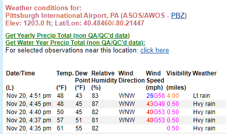
-
Pittsburgh, PA Fall 2024 Thread
TheClimateChanger replied to TheClimateChanger's topic in Upstate New York/Pennsylvania
-
Pittsburgh, PA Fall 2024 Thread
TheClimateChanger replied to TheClimateChanger's topic in Upstate New York/Pennsylvania
-
Pittsburgh, PA Fall 2024 Thread
TheClimateChanger replied to TheClimateChanger's topic in Upstate New York/Pennsylvania
Severe Thunderstorm Warning PAC003-007-019-125-202215- /O.NEW.KPBZ.SV.W.0279.241120T2124Z-241120T2215Z/ BULLETIN - IMMEDIATE BROADCAST REQUESTED Severe Thunderstorm Warning National Weather Service Pittsburgh PA 424 PM EST Wed Nov 20 2024 The National Weather Service in Pittsburgh has issued a * Severe Thunderstorm Warning for... Allegheny County in southwestern Pennsylvania... Central Washington County in southwestern Pennsylvania... Southern Butler County in west central Pennsylvania... Beaver County in western Pennsylvania... * Until 515 PM EST. * At 424 PM EST, severe thunderstorms were located along a line from near Ellwood City to 8 miles north of Wolfdale, or along a line from 6 miles northeast of Beaver Falls to 7 miles east of Avella, moving east at 35 mph. HAZARD...60 mph wind gusts. SOURCE...Radar indicated. IMPACT...Expect damage to roofs, siding, and trees. * Locations impacted include... Pittsburgh, Penn Hills, Mount Lebanon, Bethel Park, Ross Township, McCandless Township, Monroeville, Cranberry, Moon Township, McMurray, McKeesport, Butler, Franklin Park, Aliquippa, Canonsburg, Beaver Falls, Monaca, Avella, Gastonville and Shaler Township. PRECAUTIONARY/PREPAREDNESS ACTIONS... Seek shelter inside a well-built structure and stay away from windows. These storms are capable of producing damaging winds. Tornadoes can develop quickly from severe thunderstorms. Seek shelter immediately in an interior room on the lowest floor of a well-built structure. && LAT...LON 4025 8049 4085 8035 4085 8016 4090 8016 4086 7969 4064 7969 4057 7977 4053 7970 4043 7970 4039 7976 4030 7979 4029 7978 4028 7980 4023 7981 4023 7978 4020 7987 4019 7986 4016 7986 4016 7990 4013 7989 TIME...MOT...LOC 2124Z 279DEG 30KT 4081 8023 4053 8029 4031 8035 TORNADO...POSSIBLE HAIL THREAT...RADAR INDICATED MAX HAIL SIZE...0.00 IN WIND THREAT...RADAR INDICATED MAX WIND GUST...60 MPH $$ Milcarek Severe thunderstorm warning with tornado possible tag. -
November 2024 General Discussion
TheClimateChanger replied to SchaumburgStormer's topic in Lakes/Ohio Valley
Still going to end up with some of the latest first flakes on record, as many areas have not even had a trace. So there certainly could have been a futility watch, even if one was never issued. Detroit - 8th latest first snow, and latest since 2004 Cleveland - will tie 1944 & 1978 for 5th latest first snowfall [each had first snow on 11-21] Alpena - 2nd latest first snow Green Bay - will tie 1918 for second latest first snow [if snow falls today] or finish in sole possession of second place [if it holds off until tomorrow] Sault Ste. Marie - latest first snow flakes on record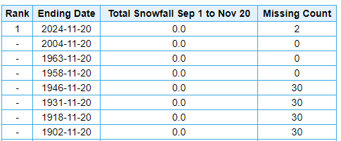


-
Let’s talk winter!! Ohio and surrounding states!! 24'-25'
TheClimateChanger replied to buckeye's topic in Lakes/Ohio Valley
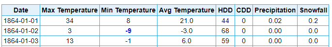
Interesting. Not many "official" weather observations are that old. Here is Lansing, Michigan from 12/31/1863 - 1/2/1864. 3 inches of snow, and brutal cold. Here is Toronto, Ontario from 12/31/1863 to 1/3/1864. 1.7 inches of snow, with a sharp cold snap. Doesn't seem that bad, unless it was worse in Ohio.


-
Pittsburgh, PA Fall 2024 Thread
TheClimateChanger replied to TheClimateChanger's topic in Upstate New York/Pennsylvania
So far every day this month has been at least 1F above normal at PIT. Looks like that streak will end Thursday, and we may string together several below normal days. -
Pittsburgh, PA Fall 2024 Thread
TheClimateChanger replied to TheClimateChanger's topic in Upstate New York/Pennsylvania
Interesting. My phone has 5.2 inches of snow for Pittsburgh on Thursday. Also, another 2.15 inches of snow on Friday (not shown).


