TheClimateChanger
-
Posts
4,598 -
Joined
-
Last visited
Content Type
Profiles
Blogs
Forums
American Weather
Media Demo
Store
Gallery
Everything posted by TheClimateChanger
-
Pittsburgh, Pa Summer 2024 Thread.
TheClimateChanger replied to meatwad's topic in Upstate New York/Pennsylvania
Wow, I didn’t realize it was that many! At least the storms brought in some temporary relief. Still not ideal for open windows with the high humidity. We must’ve dodged a bullet locally. Nothing more than some small branches down. Much needed rainfall - doubled my monthly total. Wonder if we have a repeat tomorrow. NWS is expecting temperatures as warm, if not warmer, with heights continuing to rise. Might be less coverage with a stronger ridge overhead tomorrow, I would guess? -
Pittsburgh, Pa Summer 2024 Thread.
TheClimateChanger replied to meatwad's topic in Upstate New York/Pennsylvania
Up to 94F, which matches the highest temperature since 2018. And as @TimBpointed out, I suspect some shenanigans were afoot with the sensor during that event. Prior to today, only 4 days had reached 94F since 2012. -
June 16th-21st (and beyond?) Heatwave
TheClimateChanger replied to Geoboy645's topic in Lakes/Ohio Valley
Unfortunately, the de-urban cold island effect is keeping temperatures in check at DTW.
-
June 16th-21st (and beyond?) Heatwave
TheClimateChanger replied to Geoboy645's topic in Lakes/Ohio Valley
Northwest Ohio and adjacent areas of Indiana always do well with the heat. I think it's the low elevation - almost like a depression extending from Maumee Bay out to Fort Wayne - and the sandy soils. 5 minute observations show a couple of 99F readings, so likely reached at least 98F (factoring in rounding). These values are rounded in Celsius to the nearest whole degree before conversion, whereas the official readings are rounded from the nearest tenth of a degree in Celsius. Toledo Executive Airport (KTDZ) did reach triple digits. 100F at 2:50 PM. An observation of 100F on the 5-minute observations is a true observation of 100F since it means the rounded Celsius temperature was 38C, which consequently means it was at least 37.5C (99.5F = 100F). Toledo - Toledo Executive Airport (weather.gov)
-
Pittsburgh, Pa Summer 2024 Thread.
TheClimateChanger replied to meatwad's topic in Upstate New York/Pennsylvania
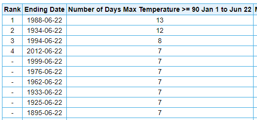
Regardless, I think some of these commenters on X forget its only June. 1988 had 4 90+ days at this point, and the 5th didn't occur until the 20th. We will be just one day below that. There were 8 by the end of June. Decent odds we match or exceed that, given the likelihood of more heat before the month is through. The mean temperature for June 1988 was 68.5F, nearly 1F below the current average. We are already at 68.4F and will be far above 70F before the end of this week. Incidentally, we've also had less than half the amount of rain this June compared to what we had at this point in June 1988, at the airport. I've barely managed a third of an inch IMBY so far. Of course, this also began a stretch in 1988 where there was basically no rain until the middle of July. Heat built back in on the 4th that year with a high of 93 after a low of 54! I think these same people would be saying "it's JUST SUMMER!" on July 4, 1988. And if someone pointed out that there's been more 90s recorded than in X number of years [decades], they'd say "it hasn't felt that hot. I've had my windows open most nights!" given all the nights in the 40s and 50s. Of course, after the 4th through August, it was a blazing inferno. Could be a case of "be careful what you wish for." -
Pittsburgh, Pa Summer 2024 Thread.
TheClimateChanger replied to meatwad's topic in Upstate New York/Pennsylvania
Also part of the reason why 1992 doesn't look that cool at most of the airports. At PIT Airport, it's only 8th coolest summer [tied with 1960], but on NCEI (which obviously has a lot more data), it's second coldest for Allegheny County [since 1895]. 1992 being the one year that stands out in the era due to the Pinatubo eruption. -
Pittsburgh, Pa Summer 2024 Thread.
TheClimateChanger replied to meatwad's topic in Upstate New York/Pennsylvania
Well, the 103F on July 16th is probably legitimate. But honestly, yeah, I suspect the others would have topped out in the upper 90s. I get flamed frequently for bringing this up on here, but I'm not making it up. There's literally a plethora of studies showing the readings from the era to be high. Obviously, 1988 was super hot either way. Of the 38 days of 90+, 26 of them were 93 or better. But it's not 100% comparable to the current siting and equipment. And not all readings, just at the "first order" climate sites - typically larger airports. -
Pittsburgh, Pa Summer 2024 Thread.
TheClimateChanger replied to meatwad's topic in Upstate New York/Pennsylvania
The history of temperature measurement in America is to constantly produce cooler readings as technology has improved and standards revised, and then have people complain about adjustments and claim it was hotter in the past. Considering the ASOS is installed at 1,203 feet ASL and the buildings in which the downtown temperatures were taken many decades ago were from about 720 to 750 feet, taken on a rooftop with only passive solar shielding (LiG thermometer housed in a shelter, and no fan aspiration), one can only wonder what the temperature would be today. Absolutely ridiculous that mean temperatures over the past 24 months have been on par with the hottest years in the threaded record. Anyways, y'inz stay cool out there this week. Already up to 82F as of 9:51 a.m., with a heat index of 84F. 90+ looks like a foregone conclusion today, unless a storm forms by noon and sits over us the rest of the day. -
Pittsburgh, Pa Summer 2024 Thread.
TheClimateChanger replied to meatwad's topic in Upstate New York/Pennsylvania
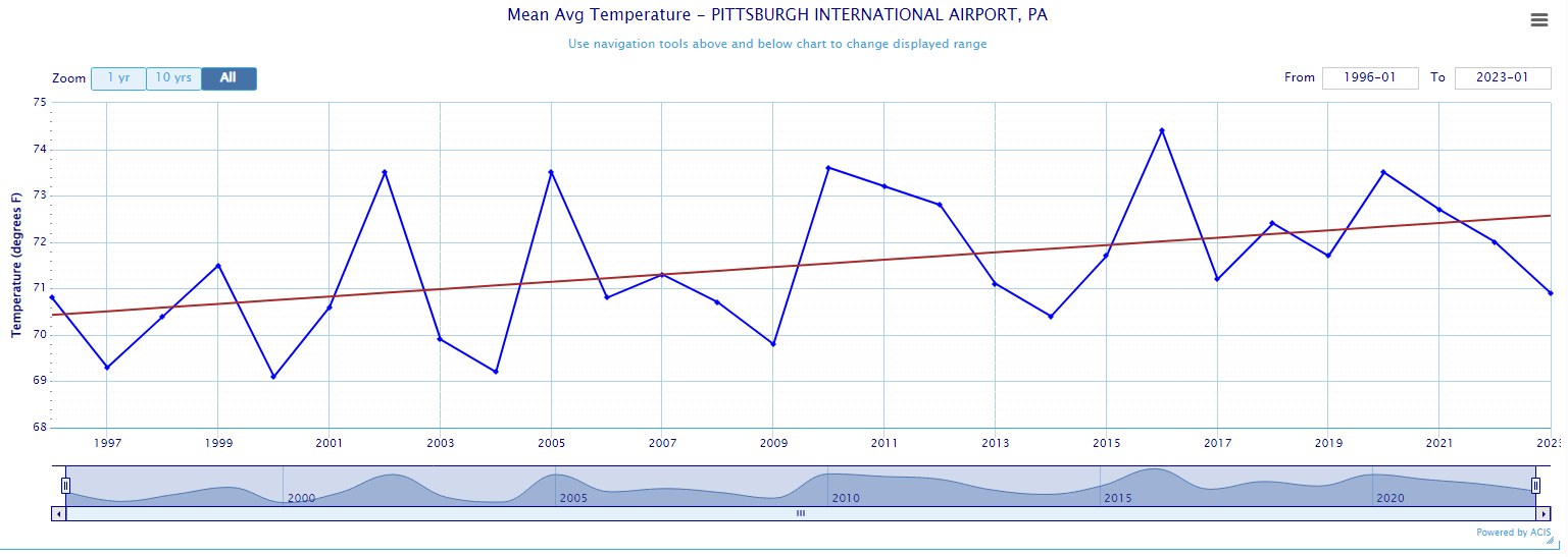
When you consider instrument bias, what looks like a similar (if not hotter) stretch of summers in the late 1980s and early to mid 1990s, in fact, is cooler than most recent summers. You can choose not to believe this, but my bet would be warming will soon be sufficient to surpass 1995. And in the next couple of decades, warming will be substantial enough that numerous summers will be surpassing 1995. Because that's what the trend shows since installation of the ASOS in 1996. We finally have nearly 30 years without the NWS making some significant change to siting or instrumentation, and look, it's warming and FAST. Regression shows 2.2F of warming over that period in the summertime.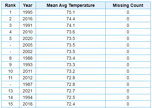
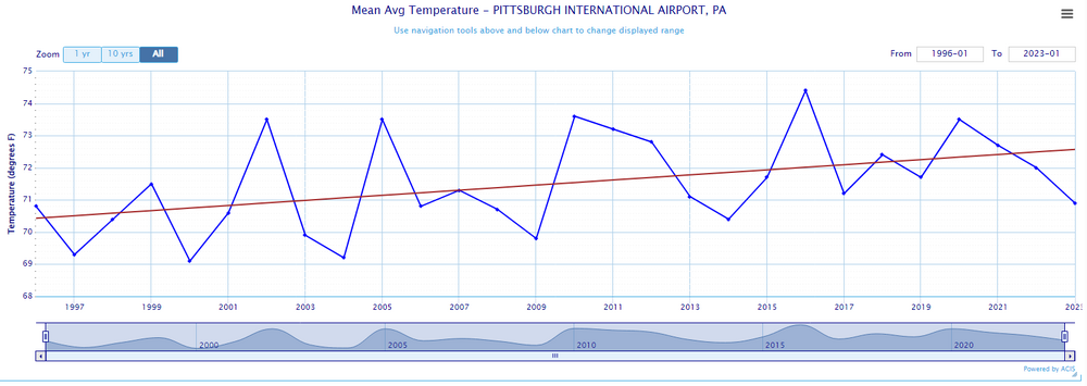
-
Pittsburgh, Pa Summer 2024 Thread.
TheClimateChanger replied to meatwad's topic in Upstate New York/Pennsylvania
IMO, the problem boils down to this: The NWS sees "oh, this is the strongest ridge on record" and looks at past similar setups and then correctly assumes temperatures will be even higher this go around. Makes sense, since H85 temperatures are higher and ridge heights much higher, but there's no bias correction from the past observations. I've repeatedly - and correctly - pointed out that ASOS runs about 1-1.5F cooler than the HO-83 hygrothermometer it replaced in 1995/96. There's a reason why so many of those summers in the roughly 10-year span when the defective HO-83 was in place are among the hottest on record. The bias was not equal between night and day, but higher during the day - particularly on sunny days with light wind and a high sun angle. The same conditions that are typical of heat waves. So some of those days were likely overcounted by 2, 3 even 4F. This also coincided with some hot summers, no doubt, but not as hot as the records would suggest. Sources: climo_rpt_96_2.pdf (colostate.edu) - Study of 79 first-order climate sites between 1994 & 1995 found an average annual max temperature bias of +1.16F, and an average annual low temperature bias of +0.95F from the HO-83 relative to the ASOS installation. Comparison of ASOS and HO-83 temperatures at Lincoln, Nebraska from November 1991 through October 1992 (noaa.gov) - 12-month study from Lincoln, Nebraska study 1991-92. ASOS was from 1.4 to 2.6F cooler for maximum temperatures every month, and from 0.7 to 2.5F cooler for minimum temperatures. An Investigation of Temperature Discontinuities Introduced by the Installation of the HO-83 Thermometer in: Journal of Climate Volume 8 Issue 5 (1995) (ametsoc.org) - Another study, somewhat smaller estimate of 0.6C bias - actually suggests less bias in summer, but not sure that is correct. Ironically, I learned about this decades ago from climate change deniers. At that time, they were blaming climate change (in part) on this faulty sensor. Obviously, a ridiculous argument since U.S. first order airport sites make up a very small fraction of the USHCN sites, and almost zero percent of the global climate stations [the majority of which is water, after all]. But I correctly guessed it would turn to pointing to these same years as being evidence it wasn't warming as much as they said. The HO-83 Hygro- thermometer « Climate Audit - cites some more sources, particularly about Tuscon and how the NWS could not confirm a global warming signal in the deadly Chicago heat wave of 1995 because the readings were likely inflated by instrument bias -
Pittsburgh, Pa Summer 2024 Thread.
TheClimateChanger replied to meatwad's topic in Upstate New York/Pennsylvania
-
Pittsburgh, Pa Summer 2024 Thread.
TheClimateChanger replied to meatwad's topic in Upstate New York/Pennsylvania
-
I think it factors in climo. Point-click centered on Bradford Regional Airport in north central Pennsylvania has 92, 95, 95, 93 and 91 next week. Since records began in 1957, there have only been 2 June days there in the 90s: 90 on 6/16/2022, and 93 on 6/22/2022. The all-time record is 97F on 7/16/1988 and 7/21/2011. And only one year saw more than 4 90+ readings: 1988, with 8.
-
Central Pa. Summer 2024
TheClimateChanger replied to mahantango#1's topic in Upstate New York/Pennsylvania
Centered on the airport has 92, 95, 95, 93, and 91 Monday through Friday. There have only been two days in the 90s in June since records began at the airport in 1957: 90 on 6/16/2022 and 93 on 6/22/2022. The all-time record is 97F on 7/16/1988 and 7/21/2011. Only one year has had more than 4 90+ days: 1988, with 8. So if that comes to fruition, you would have more 90s than any entire year on record except for 1988, and 5 days in a row with temperatures that are either warmest or second warmest of any prior June day. Other than the fluke 93F in 2022, no other June exceeded 89F. -
Pittsburgh, Pa Summer 2024 Thread.
TheClimateChanger replied to meatwad's topic in Upstate New York/Pennsylvania
Wtae does have a 97 for next Saturday, but that’s really far out. Anyways, getting a decent thundershower here. No wind, but moderate rain and some thunder & lightning. -
Interesting little random patch of fog on southern Lake Michigan.
-
Pittsburgh, Pa Summer 2024 Thread.
TheClimateChanger replied to meatwad's topic in Upstate New York/Pennsylvania
The weather algorithm must have broke.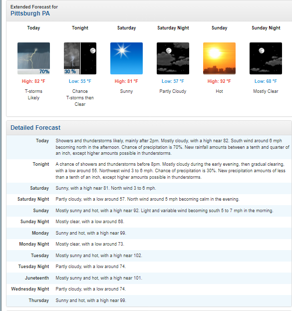
-
Stick a fork in it, people.
-
Pittsburgh, Pa Summer 2024 Thread.
TheClimateChanger replied to meatwad's topic in Upstate New York/Pennsylvania
Worried about flash drought too, depending on how much rain falls today. I’ve only received about a quarter of an inch this month, and the airport is just over a third of an inch. CPC didn’t include western Pennsylvania in the flash drought outlook, presumably because it’s been one of the wettest starts to the year. But given the lack of rainfall recently and the prospective heat wave and continued lack of rainfall, they probably could have. -
Pittsburgh, Pa Summer 2024 Thread.
TheClimateChanger replied to meatwad's topic in Upstate New York/Pennsylvania
-
June 16th-21st (and beyond?) Heatwave
TheClimateChanger replied to Geoboy645's topic in Lakes/Ohio Valley
Looks like flash drought potential for the Ohio Valley, including parts of the eastern Corn Belt, and Mid Atlantic. -
The first 90F of the year at Detroit. Current forecast has 90s Monday through at least Thursday (see below). If it can get to 7 90+ days by the 22nd, that would be pretty elite territory. Only 3 years have had more than 7 90+ days by June 22 at Detroit, and it's some impressive company [1934, 1988, and 1994]. Sunday Partly cloudy in the morning then clearing. Highs in the mid 80s. Sunday Night Partly cloudy. Lows in the upper 60s. Monday Warmer. Partly cloudy. Highs in the mid 90s. Heat index readings in the upper 90s. Monday Night Partly cloudy. Lows in the lower 70s. Tuesday Mostly sunny in the morning, then becoming partly cloudy. Highs in the mid 90s. Heat index readings in the upper 90s. Tuesday Night Partly cloudy. Lows in the mid 70s. Juneteenth Partly cloudy. Highs in the mid 90s. Heat index readings in the upper 90s. Wednesday Night Partly cloudy. Lows in the mid 70s. Thursday Partly cloudy. Highs in the mid 90s.
-
Central Pa. Summer 2024
TheClimateChanger replied to mahantango#1's topic in Upstate New York/Pennsylvania
Also true, although the latter half of June kind of bucks that overall trend with the majority being observed at the airport - mostly 1994 and 1988 (including 2 of the dates when 98F was reached). -
Central Pa. Summer 2024
TheClimateChanger replied to mahantango#1's topic in Upstate New York/Pennsylvania
True to an extent, but at least in June, the daily records there are only 2 or 3F warmer on most days. The all-time record is 100F (last set in 1966), and the highest hourly heat index is 112F. That's also at the airport, which is only about 300 feet above sea level. So anyone living in a more elevated location of south central Pennsylvania can probably shave 2-4F off those readings. -
Central Pa. Summer 2024
TheClimateChanger replied to mahantango#1's topic in Upstate New York/Pennsylvania
I guess it depends on your definition of insanity. Considering the all-time record June temperature in Pittsburgh (since 1874) is 98F, and the highest hourly heat index in the month of June (since 1942) is 106F, the latter would definitely qualify as insanely hot in Pittsburgh. I'd have to say mid 90s is probably the threshold for June. That would get you near the daily record on all but a handful of days in the month.