jwilson
-
Posts
1,231 -
Joined
-
Last visited
Content Type
Profiles
Blogs
Forums
American Weather
Media Demo
Store
Gallery
Everything posted by jwilson
-
Western PA/Pittsburgh Winter 2021/22 Discussion
jwilson replied to meatwad's topic in Upstate New York/Pennsylvania
If winter and cold is what you're still after, you can sort of hold out hope for now. There's no more 50 degree days in the long-term until around March 5th. It barely touches 40 over the next two weeks. That warm-up is also like the others: two days and then back into the freezer, with ample cold dumped into the U.S. (likely due to that strengthening -EPO). That could change, of course, but for now, as long as cold is around, it leaves an opportunity for snow. I'm personally ready for an early spring, but it looks like we're going to hold onto winter for a while longer. If we can't eek out more snow in the pattern, that would have to be considered a disappointment. -
Western PA/Pittsburgh Winter 2021/22 Discussion
jwilson replied to meatwad's topic in Upstate New York/Pennsylvania
I don't love the trough alignment for the system next Friday. The longwave pattern screams cutter to me. Ridge too far west off the pacific coast. Not that it can't change, but for now that would be the concern if you're still looking for snow. The Euro and Canadian take a slightly different tact in not intensifying the central LP as deeply and it basically skirts a boundary nearby. Seems much less likely than a cutter. That said, the pattern looks a bit more conducive coming into March. Pretty similar look to January. The only issue is that's basically fantasy land. Long-term, who knows. OP GFS wants to sink the PNA and flood us with warmth, but a fairly strong -EPO may assist in continuing to push cold air down into the CONUS. -
Western PA/Pittsburgh Winter 2021/22 Discussion
jwilson replied to meatwad's topic in Upstate New York/Pennsylvania
As soon as the groundhog saw his shadow, we knew it had to be over, right? I'm fine with an early spring. January exceeded my expectations to some degree, and I never really expected some blockbuster, wall-to-wall winter. March is always a wildcard, too. You never know what might happen. -
Western PA/Pittsburgh Winter 2021/22 Discussion
jwilson replied to meatwad's topic in Upstate New York/Pennsylvania
I'm good with some down time from tracking after January. It was almost constant since New Year's. At this point I'm chasing the big one and that's about it. It's been at least six years since we've even sniffed the two-footer, same for places further east of us which seems like a semi-drought given recent climatology. I don't have high confidence of one occurring this year. We don't have the right kind of blocking setup. I would say next year looks slightly more promising with a Nino prediction. -
Western PA/Pittsburgh Winter 2021/22 Discussion
jwilson replied to meatwad's topic in Upstate New York/Pennsylvania
I have a friend that's a meteorologist in a southern market and did his thesis on public communication related to weather broadcasting and forecasting, etc. It's pretty interesting how he approaches his forecasts, and I think it's something a lot of on-air mets (among others) miss. There's not enough discussion about the nuance of storms, really. And I realize the "general public" is overall kind of dumb so you can't wade too far into the minutiae, but I think a lot of mets skip over the grey-area talking points and focus too much on black-and-white numbers. This does vary by forecaster, however. We even see the local NWS has good discussions and bad ones. I'm guessing there are not enough college-level courses on communication in this context, and some people are better communicators than others, naturally. Regardless of how you felt about the last couple storms, there were obvious issues that some mets didn't really touch on or discuss enough. I see some of the same things here on the board. I wish we would ban Kuchera snowfall maps because those things fail to verify 99% of the time. It only serves to create unrealistic expectations. Actual precip forecasting requires multi-level and layer analysis. Same with attempting to discern ratios. (I'm being mostly facetious here with that Kuchera point, but I do think those maps should be largely ignored.) -
Western PA/Pittsburgh Winter 2021/22 Discussion
jwilson replied to meatwad's topic in Upstate New York/Pennsylvania
At this point, I'm just hoping the models are under-developing surface warmth. Looking at the NAM, for example, we'd be talking about significant icing. The kind of ice that threatens power outages and tree damage, among other things. 12-18" of frozen precipitation and almost none of it is snow. A fairly thick warm layer from 700-850 for most of the duration. Maybe that dryslotting could help cut back precip totals, as well, but pretty much all the models have us approaching 2" of total precip. With snow mostly off the table, I'd rather have plain rain. The lower-res models show more of a sleet bomb. Pretty rare to get measurably accumulating sleet. -
Western PA/Pittsburgh Winter 2021/22 Discussion
jwilson replied to meatwad's topic in Upstate New York/Pennsylvania
I agree. The cold air is moving in too late. If we had that high about 12 hours earlier, we might be in the game, but there's a rather large sleet signature for anything that isn't rain. The 12Z GFS, for example, shows 10" of sleet or ice. That's the period where the 850 temps are still above freezing. The GFS might be 3-6" of snow on the backend. Big IF, though, and the GFS is the absolute best show for us right now. Every other model is less generous. The look at 500H isn't one of a "big snowstorm," either. The trough alignment is awful. I think our best hope is this system resets the trough for energy behind it giving us a better shot at snow. The GFS tries to show this with a ball of energy on Monday, but even right now I'd say it's not quite right. Goes negative too soon. Won't analyze it further, though, because we have to wait for this FROPA to go through. -
Western PA/Pittsburgh Winter 2021/22 Discussion
jwilson replied to meatwad's topic in Upstate New York/Pennsylvania
The GFS at the end of the run is pure "Goofus" territory. A 36-hour ice storm for VA, NC, and SC. That glorified frontal passage on Friday looks "meh" to me right now. The setup doesn't typically result in deep snow drifts. We'll see if anything changes. -
January 28th/29th Event Obs - From KU to FU?
jwilson replied to JTA66's topic in Philadelphia Region
It looked like the heavier bands really struggled to make it across the Delaware, for the most part. My mom's place in Hatboro has like 4-6" but evidently it's quite windy and the light, powdery snow has been blown around easily. With all these NS coastals and La Ninas, it might be time to get a shore place as a snow cabin. -
January 28th/29th Event Obs - From KU to FU?
jwilson replied to JTA66's topic in Philadelphia Region
Anyone down in Dover? They must have a nice pile already, right under all that confluence. -
January 28th/29th Event Obs - From KU to FU?
jwilson replied to JTA66's topic in Philadelphia Region
Looks like between 11 PM and 1 AM, from south to north. Assuming it maintains a somewhat north-NE trajectory. -
January 28th/29th Event Obs - From KU to FU?
jwilson replied to JTA66's topic in Philadelphia Region
I was just looking at those myself. Rooting for you guys to score; one SREF member has 30" for PHL. Better ride that one! Mean is 8.31" in Philly. That's almost double the previous run. -
Western PA/Pittsburgh Winter 2021/22 Discussion
jwilson replied to meatwad's topic in Upstate New York/Pennsylvania
Tracking stuff like this is enough to make you miss El Nino winters with southern-stream dominant precip bombs, even if it means rain. These NS systems are so bipolar. -
Western PA/Pittsburgh Winter 2021/22 Discussion
jwilson replied to meatwad's topic in Upstate New York/Pennsylvania
Haha, I promise it's not intentional. I try to be realistic about things. Ironically, the 18Z GFS got really close to the NAM solution and continued the trend from the previous two runs. There are still very subtle differences, with the ridge being slightly steeper and elevated on the NAM, while the GFS wants to tamp it down some. The trough is also broader on the GFS than the NAM, which seems to push the surface low development just slightly off to the east and north. We're talking OBX versus Cape Fear, a pretty minimal variation. Both genesis the low off Jacksonville, FL. The GFS wants that rapid NE movement, though. I guess this is where I have a knowledge gap because I honestly don't understand that surface depiction from the GFS. To me, the energy is actually even better consolidated than it was at 6Z Monday, which was the tightest coastal solution the GFS has shown of late. If you compare the trough between the two, the 18Z run today has dug fairly significantly further south. The 540 line is over Huntsville, AL as opposed to Bowling Green, KY. Especially if you saw these two runs side-by-side, you'd look at the 500H today and almost certainly think, "that's turning the corner and would be the better outcome." But it doesn't. I'm having trouble understanding why. Maybe the ridge out west being just a little flatter above Boise is enough? Is the 850 low too far to the east and needs captured? For now those are my only theories. The way it looks at 500, I think, would result in some more northward pull, unless that 850 gets off the coast and moves everything with it? -
Western PA/Pittsburgh Winter 2021/22 Discussion
jwilson replied to meatwad's topic in Upstate New York/Pennsylvania
I would definitely take some early overrunning snows as the low deepens offshore, even if we miss the wrap-up. That said, it's a classic 84-hour NAM signature. Must be part of its programming. At 0Z I'll expect this to be 250 miles offshore and much drier. -
Western PA/Pittsburgh Winter 2021/22 Discussion
jwilson replied to meatwad's topic in Upstate New York/Pennsylvania
I'm shocked people are trusting the Euro to get this right. It's been beaten consistently by the GFS over the last month. There were two runs yesterday where it looked like you might get consistency, only for the models to immediately relent on the phasing and make it a Nantucket special. The setup remains quite precarious, with a delicate phase required to get anyone south of Boston into the snow. That's likely why you'd have to favor it not happening. That said, the trends over the last three runs have been to pull in that southern energy more and more leading to an earlier phase, rather than leave the energy elongated and lagged in the west. The differences in 12Z from yesterday to today are quite subtle: more shallow ridge out west and a trough that's a bit too neutral and open. The Canadian solutions are a little more obviously contrasted, but the 12Z run from yesterday for that was an extreme solution and always unlikely. I would ride the GFS for this one and unless it goes back to an earlier phase and a steeper ridge position, it's probably game over outside of coastal New England. -
Western PA/Pittsburgh Winter 2021/22 Discussion
jwilson replied to meatwad's topic in Upstate New York/Pennsylvania
I think we can all agree we just need another one of those November 1950 storms and we'll all be satisfied.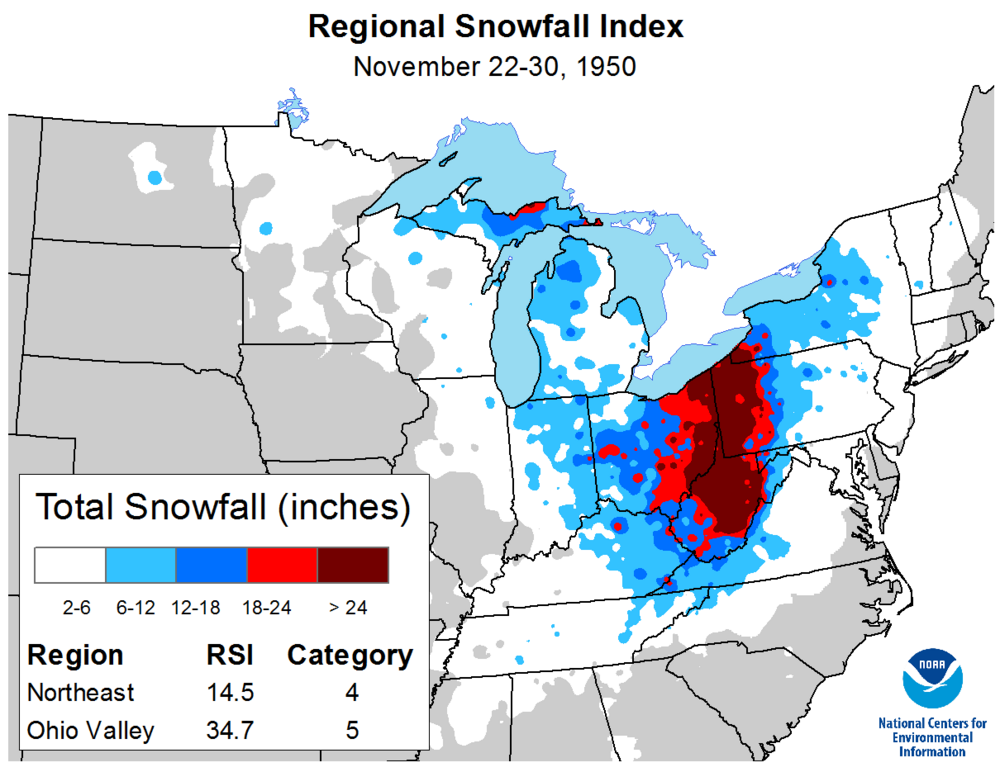
-
Western PA/Pittsburgh Winter 2021/22 Discussion
jwilson replied to meatwad's topic in Upstate New York/Pennsylvania
It's way too soon to talk details on this, but next weekend's event - as currently depicted on all the models - looks somewhat similar to the one earlier this month. A northern-stream s/w dives below the trough and amplifies in the southern states. Due to the early cut-off and bombogenesis, chances are higher than normal that this storm would ride a similar path up along the Appalachian trail. However, the GFS attempts a solution where another piece of energy in the NS acts as a kicker/barrier. The Canadian slows down the event by phasing a more substantial piece of southern-stream energy with the northern, and instead of being a kicker, that lagged or second piece of energy acts as a fuse. Unsurprisingly, the CMC version of events gets pulled further west and would potentially be a bigger hit to our area. It could also be too much of a good thing like the last storm, and with no confluence up top, it would get pulled too far west resulting in another messy solution. The GFS timing might miss our area altogether and ride the coast. The Euro also shows a storm that's probably closer to the GFS in timing/evolution but is more an inland runner. 3/3 at this lead-time is unusual, so there's little doubt it's something to put in the back of your mind for now. I do notice that none of them show a traditional block or high-pressure placement as seems to be the trend lately. For now it's not a big deal, but an important detail later. The questions will come down to timing, wave spacing, confluence, and how much (if any) southern-stream involvement. -
Western PA/Pittsburgh Winter 2021/22 Discussion
jwilson replied to meatwad's topic in Upstate New York/Pennsylvania
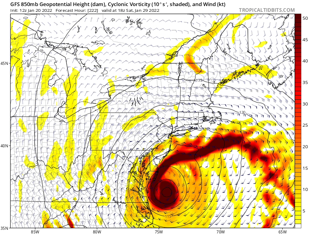
This is just for fun, in the GFS fantasy land, but I don't think I've ever seen such a pronounced and darkly colored vorticity maxima: It seems something is bound to happen that weekend but who knows what yet.
-
Western PA/Pittsburgh Winter 2021/22 Discussion
jwilson replied to meatwad's topic in Upstate New York/Pennsylvania
Agreed. I think this current week is too noisy for any one storm to really explode. Everything else is running interference and taking away some of the potential energy. Not long after my other post, the Euro - at 12Z - went towards the GFS solution. There's definitely still time to resolve it, either way, but I have low confidence in something for this week. The clipper overnight Monday into Tuesday is perhaps our best next chance for snow. Pretty standard 2-4" deal. There's a number of systems getting blown up in the long-term, but none of that is reliable right now. Unless a window clears again where there's a single piece or two of energy that can time together and phase. The GFS keeps hinting at it in the long-term, again at 18Z around hr. 240, but it's hard to take those threats seriously. -
Western PA/Pittsburgh Winter 2021/22 Discussion
jwilson replied to meatwad's topic in Upstate New York/Pennsylvania
While the Euro has better verification scores at 5+ days, the GFS nailed the last storm at about 140 hours and led the way. What does that mean for the upcoming system? We're approaching 100 hours, give or take, on this next one and the GFS still shows a strung-out solution. The CMC has waffled a little, but a few runs in a row now consistently have shown a slider. The last big solution there was 0Z Sunday. Looking at the lead-up, there are four main pieces of energy at 500H. The GFS is half-heartedly trying to phase two of them in the east, but a piece behind in the NS kicks the other northern energy out and too much is held back in the southwest as a cutoff. It's really a mess and probably could be considered too much of a good thing (as in too many s/w moving around the CONUS). But if you go back and look at the last storm, it was basically the only piece of energy in the CONUS at the time, excepting the smaller piece in the NS that dove down and helped sharpen the trough behind our main system. In that sense, the setup was much simpler. The GFS keyed on that and blew it up. The next system has to deal with much more movement across the country and a few more pieces of energy to calculate. There's also more southern stream involvement. For now I'm not sure the models can really handle what's happening at the upper levels. It's a complex arrangement and even though the GFS nailed the last storm, it may not be handling this setup as well. Unless the Euro gets some support by Thursday, however, it's going to be tough to buy anything for the weekend. Assuming the Euro would stick to its current solution, of course. -
Western PA/Pittsburgh Winter 2021/22 Discussion
jwilson replied to meatwad's topic in Upstate New York/Pennsylvania
In the end, 6-12" ended up being the right call. We didn't hit the maxima in terms of potential, but all the warning signs were there. Sleet and wind cut down on ratios and snow growth. As I stated a couple days ago, we needed that reinforcement shot of cold air to keep the 850s from roasting. We just didn't have the proper placement of high pressure to prevent it. I'd have to double check but I imagine the upper level low also gained more latitude than modeled. -
Western PA/Pittsburgh Winter 2021/22 Discussion
jwilson replied to meatwad's topic in Upstate New York/Pennsylvania
I think 6-12" is a fine call for now. There's a slight chance it overperforms locally, but this isn't the most congealed looking precip shield currently and thus accounting for potential threats to the maximum potential. On a "bust scale" of 1 to 10, I'd probably put this at a 7. It isn't the cleanest looking setup. However, in our relatively snow-starved climate for big ones, we take a double-digit potential any day even if it comes with caveats. Hope for the best as we watch it roll in. -
Western PA/Pittsburgh Winter 2021/22 Discussion
jwilson replied to meatwad's topic in Upstate New York/Pennsylvania
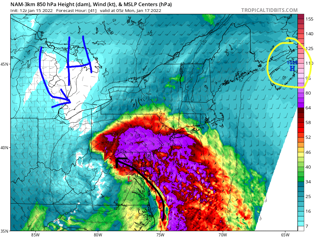
We can see the problem quite evident on the NAM (among other high-res models): Off to the northeast (circled in yellow) is the retreating high pressure. It's also not particularly strong. The high pressure I've added (to the northwest) is what we really would prefer to see in this situation, or at least due north in southern Quebec. Unfortunately, that doesn't exist. It would act to reinforce the cold air and provide some resistance to counter warm ocean flow in the mid levels. It could also limit the latitude gains by the low pressure(s). The NAM is definitely the strongest with this easterly fetch feature, but the RGEM is close there, too. The other problem is the dryslot, and if the precip cuts off, that would allow for more warm air to seep into the equation. Now I can't say for sure if the NAM is right on this, and I'm not an expert so I defer to those that are. However, I'm personally hesitant when I see these features creeping up on the short-term. This storm definitely has a high bust potential for someone, while for someone else it might over-deliver. The question simply becomes who is left with each of those outcomes. We've also seen, when there's little resistance upslope, captured lows get pulled further to the north than expected. Not that it's guaranteed here, but another possible observation. It really will come down to nowcasting. No model is going to have this exactly right.
-
Western PA/Pittsburgh Winter 2021/22 Discussion
jwilson replied to meatwad's topic in Upstate New York/Pennsylvania
Not at the end of its envelope. Better to wait, like the NAM, until it's in a more usable range (24-48 hours).