-
Posts
1,231 -
Joined
-
Last visited
Content Type
Profiles
Blogs
Forums
American Weather
Media Demo
Store
Gallery
Everything posted by jwilson
-

Pittsburgh, Pa Winter 2023-24 Thread.
jwilson replied to meatwad's topic in Upstate New York/Pennsylvania
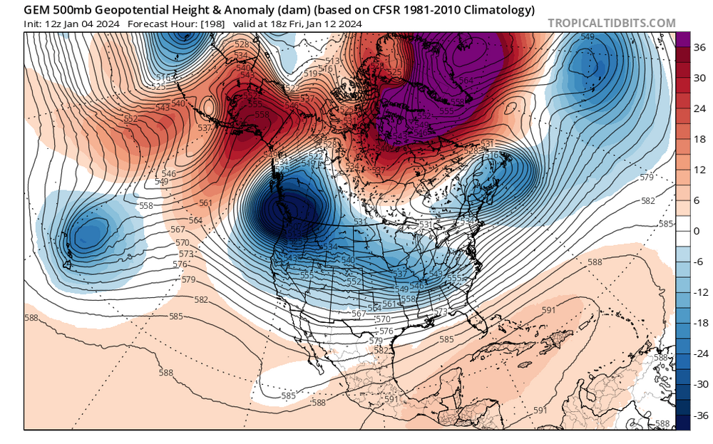
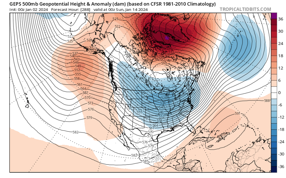
Agree on your last point, and I'd be remiss to mention that there's a chance we could be dealing with a train of cutters while the West and that nasty -PNA sorts itself out. Unfortunately, the long-range Euro looks a lot like the CMC (GGEM) in this regard, while the GFS essentially has a +PNA at that same time, which is what would help drive our MLK weekend storm. Which suite has the better grasp? Is the GFS too fast and progressive with the pattern? However, what the GFS doesn't have that the other two do is a strengthening Alaskan ridge. Get a -EPO and a -NAO formed into a massive longitudinal block and everything is forced underneath into the U.S. THAT would be an interesting development. I really think in the next 45 days or so there will be at least one significant KU somewhere. Whether we feel those same effects is the pertinent local question. -

Pittsburgh, Pa Winter 2023-24 Thread.
jwilson replied to meatwad's topic in Upstate New York/Pennsylvania
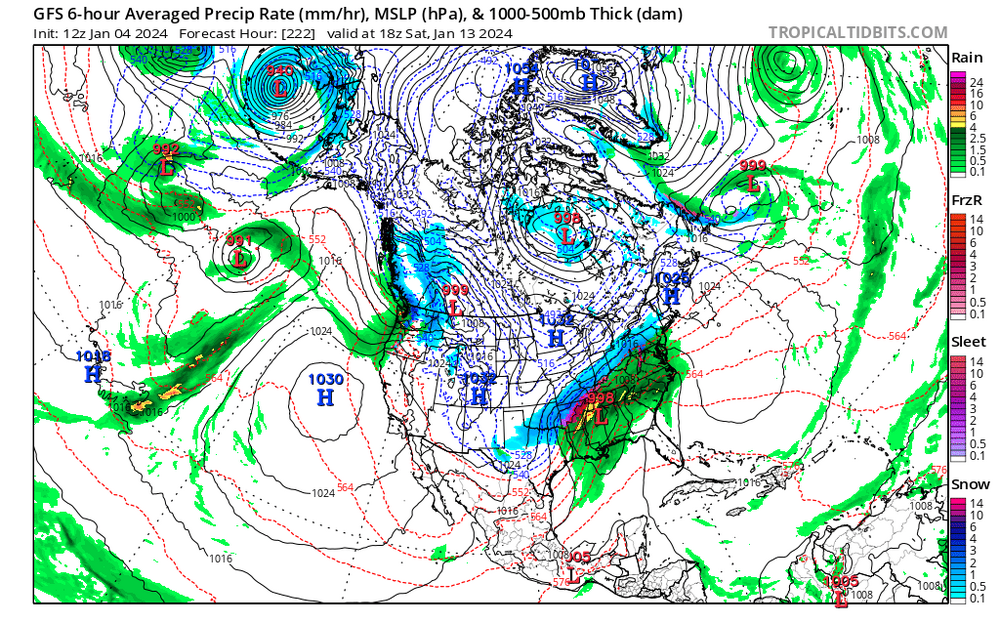
I just ran through the 12Z run, and I think the first period to watch for something is next weekend. Caveat emptor: we've seen the danger with long-range solutions. If you're still depressed by long-range tracking then look away now and don't come back until next Friday. The Canadian has a beautiful look with a 50/50 held in by the growing eastward -NAO block. The shortwave is rolling through Tennessee. The evolution shows suppression, which is possible, but that sort of detail at this range is largely ignored. For now we're just looking to get the players on the field. The only problem is it's sort of on its own at that particular timeframe. The GFS has something a little later with a ridiculous spike in the western ridge. The GFS holds the energy back which corresponds with its deep central trough paired with the aforementioned ridge. The Canadian is dropping a massive -PNA at this same time, so they are basically opposites in the west, but the GFS potential would be even greater. It runs the low right up the Appalachians after deepening in the Gulf. It also shows a TPV lobe splitting and settling in to the north of us. The GFS also shows that beautiful triumvirate of High pressures, a Banana high +1. The question would be which of these elements wins out: the -NAO, the Southeast Ridge, or the TPV lobe? That SER actually helps to push the storm further inland, which might be better for us in Pittsburgh and worse for the coastal areas, but it could also be too much of a good thing. Then there's the blocking which modeled too strong or too weak can alter the formula. The other danger here is this is the first operational run to show a solution like this, so it could easily disappear at 18Z, thus taking the time to analyze it pointless. HOWEVER, the look from the GFS is mostly supported by all the Ensembles (GEPS, GEFS, and the EPS). They all show these players in position (West ridge, central trough, SER, transitioning TPV). They aren't exact mirrors but close enough at 200+ hours to consider the OP isn't totally off on its own. BUT, once again - I mainly wanted to point to the potential of the MLK weekend. Maybe we come up empty. Right now it looks as if we could have a better front-end position for something (unlike this weekend). Hopefully those looks don't evaporate now because, dammit, I tried! -

Pittsburgh, Pa Winter 2023-24 Thread.
jwilson replied to meatwad's topic in Upstate New York/Pennsylvania
This is the problem with modeling in a fast flow. The models waffle all over the place constantly, and there's all these discrete pieces of energy, they can't decide what's going to win. It might become a nowcast event, but I still think the long range holds promise. That big -NAO block hasn't gone away, and the longer range shows a relaxation of sorts for the -PNA. Maybe it just comes down to timing something right or watching for that block to relax. There's real potential, which is more than I can say for the last couple years. -

Pittsburgh, Pa Winter 2023-24 Thread.
jwilson replied to meatwad's topic in Upstate New York/Pennsylvania
For whatever reason, I don't know the answer, those Miller A tracks are seemingly less frequent now. I would assume Miller As are more common in Nino winters because of the stronger forcing from the STJ while Ninas are more northern stream dominant, and we've had a long-term Nina-esque background state that could be a limiting factor. The last really big storm traces back to the Super Nino season in January 2016. Sadly, Pittsburgh metro was largely fringed during that storm, but I know Morgantown got about two feet. Almost all of the storms in recent history have been true Miller Bs or some kind of hybrid that combines an inland primary phasing with an emerging gulf low. Yeah and that's what I'm seeing with the old primary in the models. They want to key on a single low - the gulf / coastal one - and phase out the other. The energy in the CONUS is scattered all over the place. Compare this weekend's look with essentially four distinct pieces of energy to next week's single bowling ball over Texas. The Canadian looks better because it's a deeper system on the Coast with a bit more energy consolidated. The Euro is between the two. Then there's the NAM which I'm pretty sure is some type of error. Haha, well I wouldn't necessarily go that far, but it's certainly no guarantee we get a hit. The GEFS at range is now showing a full-latitude ridge combining the -NAO and a southeast ridge (Phase 4 of the MJO). That's a very warm look for the entire East (January thaw?). This is paired, naturally, with a -PNA trough that dumps real cold into the West. Eventually, that cold would have to filter east, and it's the character of that evolution that would matter. Does a TPV lobe split and elongate under the -NAO block? That would be good for us. If it just cycles around out west or the -NAO weakens and creates a transient cold shot through the region, we would need a pacific pattern change to ever get a chance or get extremely lucky on timing. That's why I mentioned when the -NAO block dissipates, you go KU hunting. Time it right and you get a TPV lobe into the 50/50 which blocks a storm downstream long enough to intensify but also doesn't suppress it into North Carolina. You also move the western trough towards the middle of the country which presents an opportunity for the various jets to interact, potentially merge, while creating ridging out West and an elongated trough axis in the East. -

Pittsburgh, Pa Winter 2023-24 Thread.
jwilson replied to meatwad's topic in Upstate New York/Pennsylvania
It seems the big problem going forward is going to be a -PNA. Now we have most of the energy being held back into the west, a pronounced trough there, and zero blocking. The 50/50 is more like 60/60. The issue with the following storm is there is no competition in the CONUS, so it sucks up all the energy, and there's no block to keep it from cutting - even if it were to weaken somewhat closer to onset. That's the storm that helps setup a -NAO for the following weekend. However, the -PNA continues and could potentially cancel out the block up north. The question going forward then is: who wins between a -PNA and -NAO? Recent history suggests the pacific wins, but that's TBD. We also see, in this example, that a true Miller A will only work for the Pittsburgh area when it has time to really deepen and strengthen before approaching the coast. It has to start bombing out in the Gulf. Without the inland primary like in a Miller B, a progressive flow shunts all the snow south and east. Miller Bs present their own problems, of course, like mixing and dry slots, but without that initial primary coming across, you risk getting nothing but high clouds. -

Pittsburgh, Pa Winter 2023-24 Thread.
jwilson replied to meatwad's topic in Upstate New York/Pennsylvania
Next I wanted to look at the charts. Let's start with the 0Z from earlier. Here we can see the primary differences. Notice the flatter flow to the north of our system which acts as a quasi-block. It both prevents the storm from gaining too much latitude and slows it down a little bit. The combination results in a stronger shortwave. You also have that piece of energy along the west coast digging a bit deeper which opens the entire CONUS-wide trough. This is harder to picture at the surface, but here we see the flatter flow once again and how that energy up north was elongated and less phased. The flow is mirrored on the H500 above. The energy in the central U.S. is also less concentrated, at least partially because of the west and east coast systems separately. But then we get into the 12Z models. Here we see that west coast energy is a little less pronounced, and instead the energy over Texas is digging dramatically southward. This creates a more zonal look to the flow out ahead of it. It's less into a trough on the east coast and more straight-line. We also see heights rising up north, mostly because that energy that was spread out or elongated before is now more concentrated to the East. Here we can see that northern piece a bit better. Notice again that at 0Z it was flat and stretched. Now it's a consolidated blob pushed slightly to the East. This is helping to pump those heights out ahead of the east coast shortwave, which both pulls it a little north and also opens the flow out ahead so it can escape more freely. Instead of our storm getting trapped underneath, it is now free to slide off the coast and rotate north around the rest of the waves. These are the key pieces of energy to watch going forward. We don't have a true block so it could really go either way. But if that energy up north phases too soon, we get conditions that allow our storm to progress along the boundary instead of getting dug in. The energy behind it also isn't helping, though these pieces are all acting in concert. We might still get a nice 3-6" event, but the ceiling is much lower than if we had more optimal interactions. -

Pittsburgh, Pa Winter 2023-24 Thread.
jwilson replied to meatwad's topic in Upstate New York/Pennsylvania
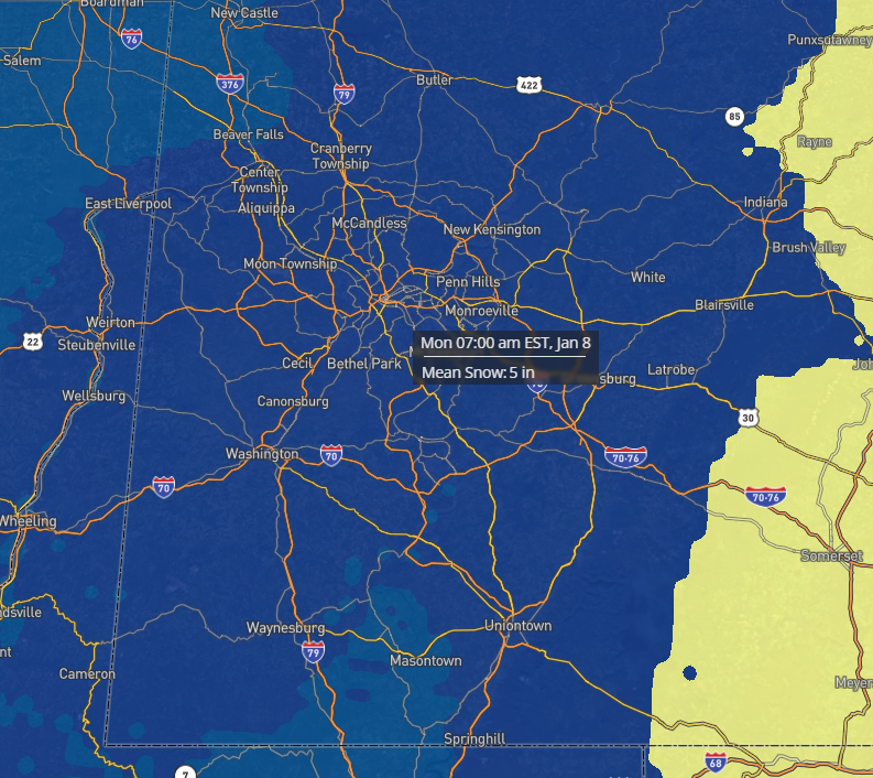
Same NBM, and considering the blend, the average snow across all models is 5" (must be skewed upward by a few big hits). -

Pittsburgh, Pa Winter 2023-24 Thread.
jwilson replied to meatwad's topic in Upstate New York/Pennsylvania
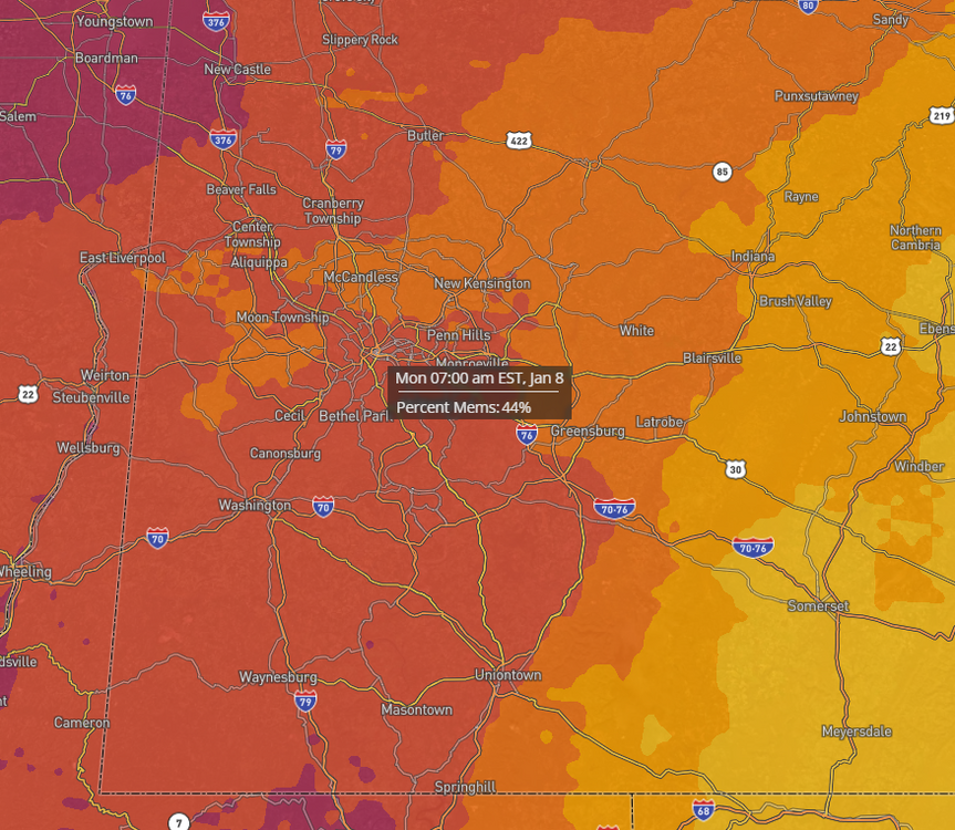
Here's the 13Z NBM (National Blend of Models). I set the threshold at 4", so right now this predicts our odds of >4" at 44%. -

Pittsburgh, Pa Winter 2023-24 Thread.
jwilson replied to meatwad's topic in Upstate New York/Pennsylvania
Bear with me, all. I'm going to make a few posts here. Haven't done this in a while so I'd like to get those snow juices flowing again. Yep. We notice a sort of "see saw" action with the energy over Oklahoma / Texas. As it digs southward, it pumps the flow ahead of it and bumps our shortwave northward. The other problem, which I'll illustrate below, is the open confluence to the north. The 12Z Euro shows this almost zonal look to the flow, but it's north enough we get better snow than at 6Z. -

Pittsburgh, Pa Winter 2023-24 Thread.
jwilson replied to meatwad's topic in Upstate New York/Pennsylvania
Since I'm here, I'm watching the 12Z GFS roll out. Looks pretty similar to 6Z thus far. Primary is pushing into southern West Virginia which is starting to get a little close for the mix concerns. The timing of this transfer is relevant. One of the big differences between the 12Z and previous runs is the energy in the Central US is digging further south and we're getting more northern stream interaction (CMC and GFS). This is a fast-moving system so we won't have time to set up for something really big, but the dynamics will determine how potent a bomb we get for 8-12 hours. It's good they are both there, because the 6Z Euro trended away from this sort of environmental interaction. Question is whether Euro follows. -

Pittsburgh, Pa Winter 2023-24 Thread.
jwilson replied to meatwad's topic in Upstate New York/Pennsylvania
To be honest, I almost want to look beyond this event and notice both the Euro and GFS setting up a rather significant -NAO block the following weekend. The ensembles and operationals all have it. Traditionally, when you would weaken a block of this magnitude is when you hunt for the KU, but it's presence looks likely to deliver us the first chance of real cold this winter. Anything that happens underneath is worth watching. It's been a while since we've had this setup. -

Pittsburgh, Pa Winter 2023-24 Thread.
jwilson replied to meatwad's topic in Upstate New York/Pennsylvania
Half of the 30 GEFS members show a 6"+ storm for Pittsburgh metro or are very close to it. Perhaps 10 certain and then a few that are inexact given the resolution. That's not quite what I'd consider "honking," but it's still quite good at this range. A handful more show a fringe event (borderline minor to moderate or a fringe special). Five show what's basically a non-event. -

Pittsburgh, Pa Winter 2023-24 Thread.
jwilson replied to meatwad's topic in Upstate New York/Pennsylvania
There's a signal for something this weekend, which is about the best we've done in quite a while. Plus with the weekend rule in effect, that's an additional +25% to confidence scores. I do prefer this one south to start - at longer leads, that is. We know that they generally bump north gradually as the T-0 clock closes. If the starting point is us getting bullseye'd, mixed, or some kind of southern fringe solution, chances are much higher we'd lose it altogether. If we're still on the northern fringe at say 48 hours, then you start to get worried about suppression. -

Pittsburgh, Pa Winter 2023-24 Thread.
jwilson replied to meatwad's topic in Upstate New York/Pennsylvania
It is getting more difficult to extrapolate based on past data, although last year (considering previous 3-season Ninas) I didn't expect much and that turned out prescient. We hit our lowest snowfall total since the winter of 1990-91. This year I'm torn. Super Ninos can definitely be too much of a good thing, as you've already pointed out. We also don't get the same ocean influences as the coast, so while they may require certain conditions, what's good for them may wreak havoc on our own snow chances. The odds of beating last year are quite high, however. Almost automatic. We haven't had back-to-back sub 20" snowfall winters since the early 30s. Doesn't mean we'll be above average, of course. Maybe that also means we're due. I will say, almost every time we've hit +2.0 on the Nino scale, we've had <30" that winter ('82-83 was 30.1" so close enough). Not sure if we'll get to that deviation but it does look close. If so, your safe bet might be on a sub 30" winter. -

Pittsburgh, Pa Winter 2023-24 Thread.
jwilson replied to meatwad's topic in Upstate New York/Pennsylvania
Thunder and lightning here. Now it feels like Christmas! -
Little hope for Flyers or Sixers, so it's all up to the Eagles now. I do think the Phillies could have won that series were it not for a mismanaged Game 4, although two years in a row of dead bats is concerning.
-

Pittsburgh/Western PA Fall 2023 Discussion
jwilson replied to Ahoff's topic in Upstate New York/Pennsylvania
To be honest, I don't expect any real snow until January or February. Maybe we get lucky with some small stuff, but through December figures to be warmer than average. Typical El Nino stuff. -
A little disappointed we couldn't eke out a basic thunderstorm. We haven't had that many this year (at least in the South Hills).
-
I think that's probably likely as our climate moves towards a facsimile of Atlanta. Pittsburgh is a bit too far from the lakes to get the "real" influence and too far from the coast to benefit from all the coastal bombs that are forming nowadays with warming waters. Hence why the coastal sections all run in the positive deviations. It's also not at a high enough elevation to generate the kinds of mountain snows we'd see in the ranges. We tend to nickel-and-dime our way to 40" as it is, and I would imagine tiny shifts in climate can make some of those little events become less common or more likely to be rain showers.
-
The long-term pattern still not showing much sign of abating. The west dries up, and while we aren't quite as dramatically under a trough the whole time, we're still wet-looking for almost the entire period. Really everywhere from the plains on east. 2-3" over the next week.
-
The trough-in-the-East pattern still holds in the long-term. It doesn't look supremely wet, though, so it's kind of a mixed bag (only 2" of rain through the end of the month). The only real ridging in the conus is pretty narrowly focused over the central plains. This pattern will limit the heat potential, which I guess most people prefer. How much rain we end with is the question and if things change come July.
-
Looks like that's the pattern for the foreseeable future. Hudson Bay highs with everything rotating underneath and cutoff. Probably 3-4 weeks at least. I'm guessing by the end we'll have made up for most (if not all) of the deficit.
-
Next week looks like a repeat of this week with the low further south. Kind of a depressing pattern if that holds up. Figured we'd pay for that nice stretch of weather at some point.
-
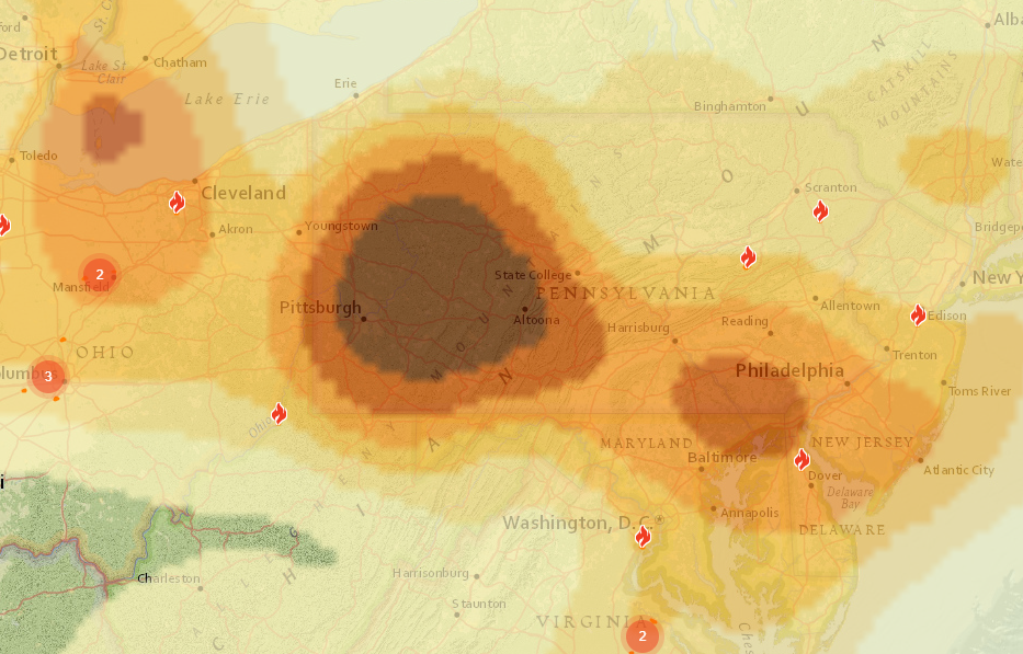
Friday could be another bad smoke day. Courtesy FireSmoke.ca - this is Friday morning say between 8 AM and Noon. We'll see if it holds.
-

Pittsburgh/Western PA Spring 2023 Discussion
jwilson replied to Ahoff's topic in Upstate New York/Pennsylvania
When is the last time PIT hit 100F? I think the last time I can remember temps that high out here was like 2012 or 2013. I lived in Morgantown back then and we did manage to go over 100F. But I think that's it. Seems pretty rare for PIT to go up there. I feel like we haven't even had that many serious heat waves over the last decade. Perhaps I'm used to worse summers coming from Philly.


