jwilson
-
Posts
1,231 -
Joined
-
Last visited
Content Type
Profiles
Blogs
Forums
American Weather
Media Demo
Store
Gallery
Everything posted by jwilson
-
Had some pea-size hail here. Nothing extraordinary, but it was quite heavy in two spurts. Shows up quite well on radar, too.
-
Pittsburgh/Western PA Winter 2024-2025 Thread
jwilson replied to Rd9108's topic in Upstate New York/Pennsylvania
Pittsburgh snow totals tend to be quite a localized thing. Since we don't often get even-spread synoptic stuff, the banding results in widely varying totals across the area. I know those of us in the south almost always get less than the official measurement location and places in the North Hills. A result of the microclimates. For that reason, I'd say the actual total isn't that important. Places that met or exceeded 30" this winter would be considered a win given the historical precedence combined with expectations. It's also a big improvement over the last two years which probably makes it feel snowier. -
Pittsburgh/Western PA Winter 2024-2025 Thread
jwilson replied to Rd9108's topic in Upstate New York/Pennsylvania
Not a lot of support from the ensembles, and right now it's the only model with this solution. It's also shown a larger magnitude storm many times this winter in the mid-range. None have amplified as advertised. If we're under 72 hours and have some consistency, then I might get interested. -
How many fingers and toes does it have?
-
Pittsburgh/Western PA Winter 2024-2025 Thread
jwilson replied to Rd9108's topic in Upstate New York/Pennsylvania
Odds of another synoptic snow event are gradually dwindling, especially as temps look to warm over the next couple weeks. If there's any snow left in this winter, it's probably the stuff we're seeing today: snow showers after a passing cold front. Doesn't amount to much. I put the over/under of winter at 30" and that's about where the official number sits now. -
Pittsburgh/Western PA Winter 2024-2025 Thread
jwilson replied to Rd9108's topic in Upstate New York/Pennsylvania
Really hard to find info on that January 3, 1994, storm. I found a couple small clips on YouTube, including one from the Weather Channel that says Waynesburg measured 33" of snow - which seems insane - yet the storm isn't rated on the NESIS scale at all. All I can think is the storm must have been quite localized, or Pittsburgh doesn't rate on NESIS. It's strange. I guess it was quite a minimal impact on all the main coastal cities so it dodges a rating and much historical acclaim. I would love to see the orientation of that heavy snow axis because places were supposedly registering 4-6" an hour rates according to those clips. I did hit 4"/hour rates during the 2020 storm, but it only lasted about 20 minutes. -
Pittsburgh/Western PA Winter 2024-2025 Thread
jwilson replied to Rd9108's topic in Upstate New York/Pennsylvania
'94 I was in Philly, so I don't remember a storm of any significance then. 2020 was technically double-digits, as you all pointed out. I forgot and double-checked my notes, and we hit 10.5" locally. True that qualifies, it was kind of a freak thing and quite localized because of the CCB. 2018 I was in Morgantown and I didn't get anywhere near what Pittsburgh did for that event? I don't even remember it at all. Biggest storm I had that winter was 3" locally. Let me add: those others storms I mentioned were all closer to two feet than simply double-digits, so I think my bar is probably a little higher than normal! -
Pittsburgh/Western PA Winter 2024-2025 Thread
jwilson replied to Rd9108's topic in Upstate New York/Pennsylvania
Haven't seen a double-digit synoptic event since 2016. I'm guessing next year it continues if we have another La Nina, which makes 10 years and probably the longest I've gone in my life without such an event. Growing up, I remember 1993, 1996, and 2003 most notably. Since then was 2009-10 and 2016. I'm starting to itch like an addict, lol. -
Pittsburgh/Western PA Winter 2024-2025 Thread
jwilson replied to Rd9108's topic in Upstate New York/Pennsylvania
Everyone can take a week off. Going to be quiet for a little. If another -EPO develops like the ensembles are showing, we're going to get more cold air in early March. Question is if anything becomes of that, but I think that regime prefers the cold & dry formulation we've seen already this winter. I'm still chasing a big storm. Little nuisance snows at this time of the year aren't of interest. They're fine in November and December when setting the holiday mood. -
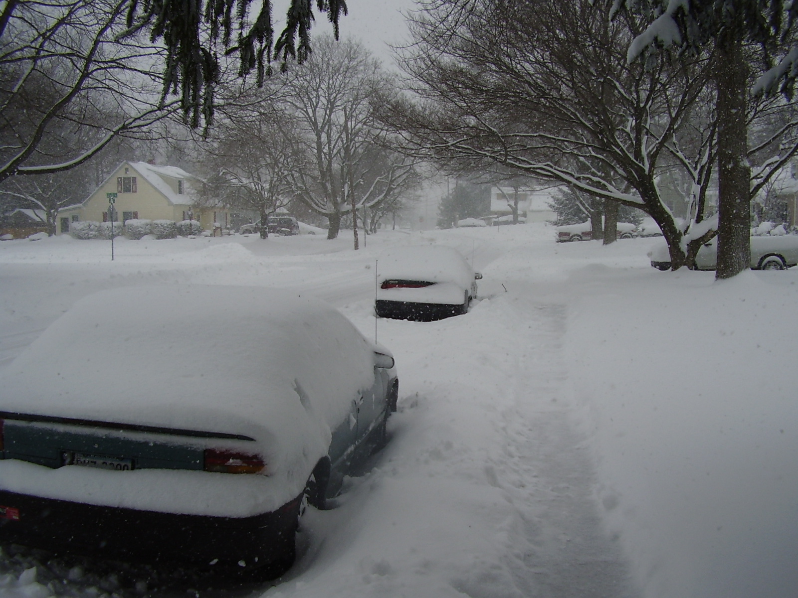
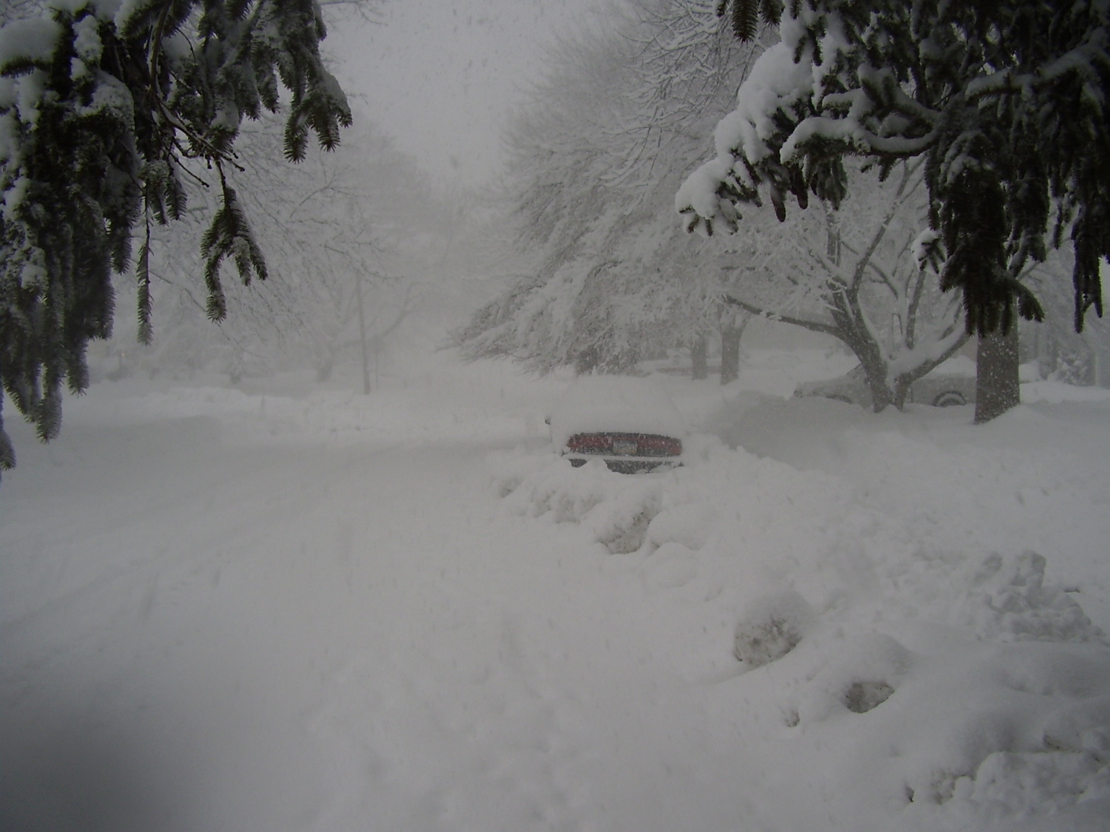
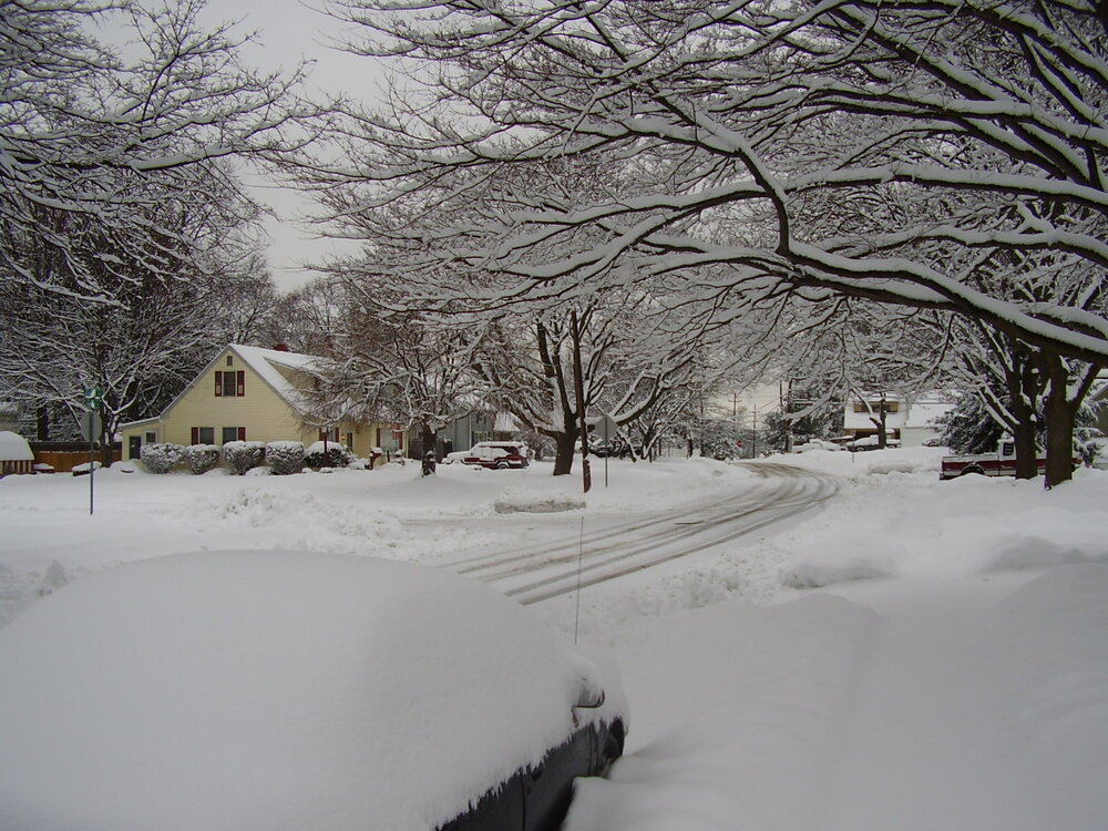
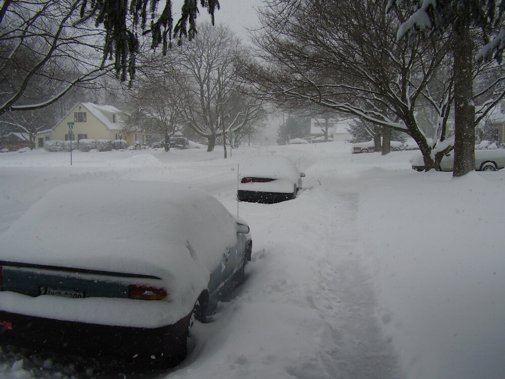
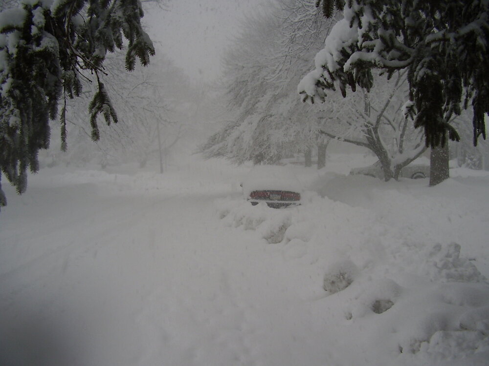
Yep, 9th-10th storm from that year. Third snow in a week. I was going through some old photos and found a bunch from that week, including some other analysis, etc. Here's your visibility progression for reference: Bottom picture is from the height of the storm. Same street, obviously, and you can see how low the visibility was during the heaviest snow. Middle pic is actually from the storm on the 6th, but I used it because it was more "normal" snow and the same general angle.
-
Missing those days...
-
Pittsburgh/Western PA Winter 2024-2025 Thread
jwilson replied to Rd9108's topic in Upstate New York/Pennsylvania
Models have intermittently teased a warm up, but with the 12Z suite, I'm not seeing anything extensive. GFS is most aggressive at the very end of its run in early March, but that's only three days or so. Seasonal trend has definitely been staggered and brief warmups followed by more seasonal cold. I guess if that continues, we wait on spring and have snow chances on occasion. -
I would think this winter failed because, in the beginning, it was primarily driven by a fairly significant -EPO phase. I don't think that's the best way to score a more typical east coast nor'easter, largely due to the position of the western ridge axis. It resulted in a numerical +PNA, which is exactly what we want, but I don't think that's the same as a +PNA that's driven more "organically," or at least coupled with an EPO that's more nuanced. The other problem was all high latitude blocking was transient. Any time the NAO or AO spiked negative, it would immediately retreat back into a positive phase. Basically, everything was relying on perfect timing to produce. Much of what was forcing storms under the Mason-Dixon wasn't primarily related to this blocking, either. It was a matter of the cold source TPV getting dumped into the CONUS with regularity because of the intense pacific flow. As others have mentioned, the speed of the pacific flow is what often gums up the works. It also seems to be reducing modeling accuracy, but that's my own speculative deduction (an educated guess). We can get these little events and cold under this regime, but like most Ninas, in general, you're talking about more cold and dry than cold and snow.
-
So when is the next warm-ENSO winter? lol
-
Pittsburgh/Western PA Winter 2024-2025 Thread
jwilson replied to Rd9108's topic in Upstate New York/Pennsylvania
Predictably, the mid-week storm is turning into another southern slider and missing PA. That's the seasonal norm. It was all too delicate and tenuous of a setup. Too many things to go wrong. It's a shame all the models at once locked onto a big solution because it's a massive tease, but I think that's the danger of model watching outside of a couple days lead. Also further demonstrates the tendencies of a cold-ENSO winter, and why the events in warm-ENSO winters are much more "stable" and easier to track. This isn't even 1996 anymore, and the increased speed of the northern jet is difficult to navigate. -
That backside low getting close to Seattle isn't at all what you want. We'd prefer it closer to the Gulf of Alaska. I guess the models have trouble with the speed of the northern jet in the long-term. You wonder if that sort of east coast amplification is even possible in this pattern. Shows how perfect the timing would have to be.
-
Pittsburgh/Western PA Winter 2024-2025 Thread
jwilson replied to Rd9108's topic in Upstate New York/Pennsylvania
Agree, that's definitely been the trend. We've seen a number of big storm looks around 180 hours and then they gradually taper to a messier, progressive wave. It's why areas south of the Mason Dixon keep winning. Nothing along the coast can amplify in this pattern. We see it here again as the Gulf of Alaska low is starting to close the distance between it and the TPV lobe. That wrecks the ridge spike in the west and doesn't allow the lobe to ride down the backside of the trough and phase. If that backside low keeps getting closer, you'll get another weaker s/w that spits sideways off the coast. D.C. might still get something, but areas from PHL north are toasted again. Models keep underestimating the speed of the northern jet in the long-term. Even the ensembles have looked great around that week mark and have been way off on snow totals. -
Pittsburgh/Western PA Winter 2024-2025 Thread
jwilson replied to Rd9108's topic in Upstate New York/Pennsylvania
I believe there's a very high correlation between a deep -AO spike relax and a significant nor'easter. Something like 90%? I can't remember off the top of my head, but we just peaked at about -5 on the Arctic Oscillation and will immediately shoot back in the other direction. That sort of quick-change is volatile. It lends credence to the idea of a major storm occurring soon, but the details are TBD. The one big problem is this not being a Nino, we don't have the typical Miller A southern juice. We can "fake" that in a way with a big phased element, but I think the overall setup is more tenuous than if this were a typical warm-ENSO pattern with overrunning. January 1996 was one of those extreme outliers, and we haven't seen that again in the 30 years since, so you know how rare it is. If you get that Gulf of Alaska low to spike that west coast ridge more, or sag the TPV lobe quicker, oriented more north-south, you could trigger an earlier phase that pulls in a more western component to the storm or start developing a wider precip shield. I think that's how Pittsburgh wins from this, but it is more difficult in this overarching pattern, and even 1996 - as the most extreme case - is barely a Top-10 snow for PIT. Granted, there's no history of anything until it happens. -
Pittsburgh/Western PA Winter 2024-2025 Thread
jwilson replied to Rd9108's topic in Upstate New York/Pennsylvania
The outlier 0Z Canadian was surprisingly close to an all-snow event for Pittsburgh. Took the surface low on a line from about Charleston to Martinsburg. GFS cuts straight up to Weirton. Euro brings it to Allegheny County. Latter two drive into the finger lakes. I think it remains quite a long shot to see a moderate snowfall from the weekend event. Front-end snow is uncertain, but I think the ceiling for that is probably 2" tops, and that's from the most aggressive GFS. The Euro is about 1" total. That's largely where my expectations lie. The reason for the difference in the CMC vs. Euro/GFS camp is the lag in the TPV on the latter two. The former moves the TPV eastward much quicker, placing it almost due north of the system. That means the system has more trouble cutting west. We are going to need that confluence to speed up, because the southeast ridge is pumping the heights ahead of the system and setting the boundary basically right over us or even to our north. If we don't get that timing right, it's a full-on rain storm. Maybe we can find a way to get lucky, but there's not much support for it in the modeling as of now. -
I think the suppressed repeat is the most likely outcome for that storm as the blocking is peaking. Hopefully not for obvious reasons, but it would seem the winter of southern MD / north central VA continues for now.
-
Pittsburgh/Western PA Winter 2024-2025 Thread
jwilson replied to Rd9108's topic in Upstate New York/Pennsylvania
Just for fun, this showed up on the long-term GFS Ensembles: Anyone have a guess as to what that looks like? I'll give you a "hint" -
-
Pittsburgh/Western PA Winter 2024-2025 Thread
jwilson replied to Rd9108's topic in Upstate New York/Pennsylvania
Everything has been flowing either north or south of Pennsylvania this winter, for the most part. Yet to have a flush hit across the state, and it looks like that trend continues. Unfortunate luck. Things cut to Chicago behind a wave of confluence or get stuck underneath one and are suppressed. -
That might be the best Eagles team ever assembled. KC had no chance. Going to have some tough losses in personnel, I think, and losing the OC again, but this team is capable of winning more if they really want it.
-
Phillies parade was fun back in '08. Getting there on SEPTA was not. Got extremely lucky an empty train rolled up to Willow Grove as we pulled in to park. I missed the Eagles' parade because of bad timing with work, but if they win again I'll be tempted to make the trip. I think they should win but Chiefs' voodoo is something else. Hopefully it's not close enough for ref influence.
-
Pittsburgh/Western PA Winter 2024-2025 Thread
jwilson replied to Rd9108's topic in Upstate New York/Pennsylvania
It's usually a red flag when your snow exists only at the backend of OP model runs. Not that it can't happen, but it's stuff you typically bet against. Pattern does look more favorable long-term, however. It's a Nina so the risk is we run dry without a strong STJ presence. Next 10 days look messy, first. Pretty reliant we get lucky on timing.