Jet Stream Rider
-
Posts
1,085 -
Joined
-
Last visited
Content Type
Profiles
Blogs
Forums
American Weather
Media Demo
Store
Gallery
Everything posted by Jet Stream Rider
-
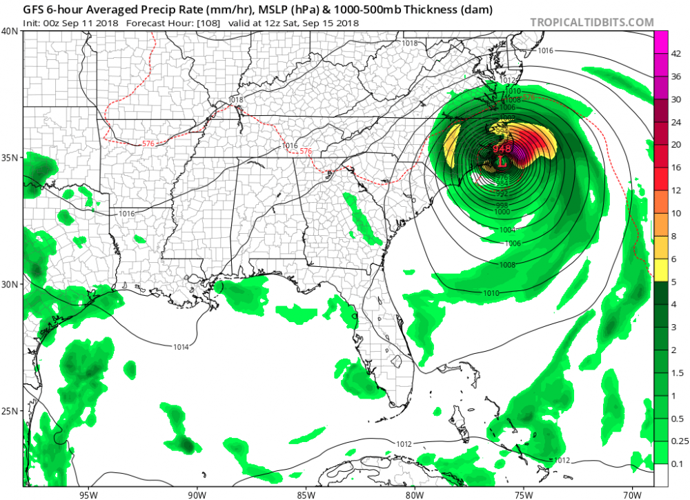
I realize that. And I'm not talking about what I prefer, but rather maybe a slight good spot in an otherwise dreadful situation. Yes the flooding could be similar to what happened with Floyd. And that's the worst I have seen in downeast NC. Still both are true. I think the thing that surprised many people with Hugo, Fran and Hazel is that the fast forward motion brought the worst of the eyewall winds so far inland.
-
At least the stall will keep the full strength eyewall winds from getting as far inland as they would with a fast moving system. I'm looking at that as a good thing. Yes, the flooding from rainfall will be worse, but if that is spread out over several days many places will be able to handle it better. And less wind inland means less power outages which keeps the pumps running. I realize its not great, but maybe its something.
-
I'm thinking the stall, if it happens soon enough will help a lot of inland folks because it would keep the buzz saw high winds of the eyewall from penetrating too far inland before Flo weakens.
-
Check date on that one. 1953?
-
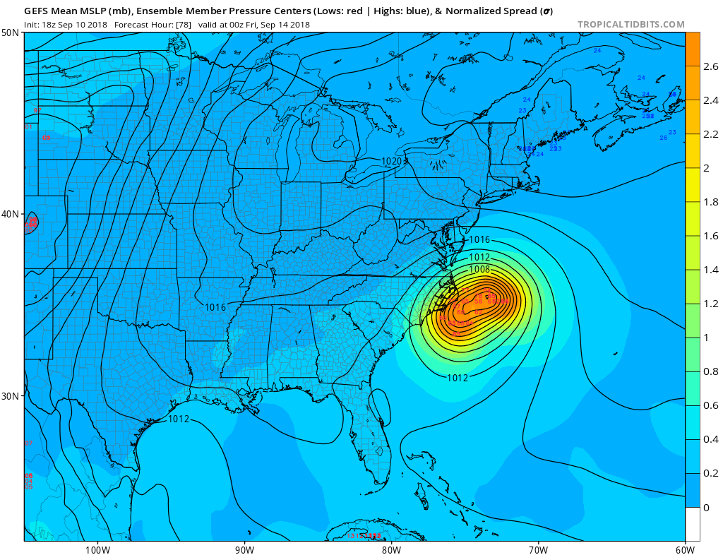
After flirting with Ocracoke, it heads back down the coast to make landfall at Myrtle Beach on Sunday.
-
Current GFS loops it in the vicinity of Ocracoke Inlet
-
Would be nice were this the solution.

-
Thought this was an interesting read. Would be great if the stall could happen soon enough and keep this thing to our east. http://www.stormhamster.com/entry/e091018b.htm
-
Can't disagree with any of that. You would likely get eye or eyewall in Greenville with that solution.
-
Yes agreed, its a good point. I thought about that as well. Everyone is looking for anything to hang our hat on. We will likely be watching for just how much will the high pressure ridge break down and how fast will the more northern component take over (if at all) even as it approaches landfall on Thursday.
-
Just a couple of notes: Thank you again everyone for all the great posts! Thank you Solak for all the latest info! The previous advisory showed a WNW direction I think and now we are back to straight W. Maybe just a transient variation, but something to watch. As No snow for you noted above, this would favor the more suppressed track of the Euro.
-
Hello everyone and thanks for all the great posts! I wish we were tracking a nice snow event rather than this hurricane. For those that have not experienced this, take it seriously. I was in the decaying eye wall of Fran in central NC and it was the most chaotic weather conditions I have ever experienced. Got a tree on my roof. Its not a place you want to be unless you are well prepared with good shelter, food and alternative power generation. Where ever that eye wall goes as it disintegrates will be trouble. Good luck to everyone.
-
Southeast Sanitarium - A Place to Vent
Jet Stream Rider replied to Jonathan's topic in Southeastern States
An amazing low pressure system. Just one section of its left "arm" stretches across half the east coast of the US. Interior sections did not do well with accumulations. And I suppose we should discuss the "Snow Hole" phenomena. It is certainly something more than just the urban heat island effect. Maybe something geographical? Strange. -
Southeast Sanitarium - A Place to Vent
Jet Stream Rider replied to Jonathan's topic in Southeastern States
We got the block, and its sitting right on top of us. Impressive large sprawling air mass. -
Southeast Sanitarium - A Place to Vent
Jet Stream Rider replied to Jonathan's topic in Southeastern States
It went boom alright, it just blew the **** up totally. lol We need something from the tropic of Capricorn region maybe. -
Southeast Sanitarium - A Place to Vent
Jet Stream Rider replied to Jonathan's topic in Southeastern States
That clipper entering Indiana/Ohio Valley region just now will get shredded by the mountains I know - but still might clip me for a flurry this evening! -
Southeast Sanitarium - A Place to Vent
Jet Stream Rider replied to Jonathan's topic in Southeastern States
Ought to get great ratios with the snow maker machine with this air mass :/ Dang it! -
Wonder how accurate this will be. 15z tomorrow. HRRR is similar
-
Dry slot and the weak slp is transitioning from the gulf to the Atlantic across the Fla peninsula
-
I agree the RGEM handled the system pretty well 24-36 hrs out so far. However, it missed the dividing line a bit in my area. Showed me in the liquid for the duration other than the final wrap around. But missed it by what looks to be 20-30 miles at this point. The freezing line is now south and east of me! I have accumulating snow!
-
Yeah, that backside on this one really seems to be persistent. Still some snow in LA, MS, and AL at this hour.
-
Might be in the game after all, sleeting here now. Apologies for the banter mods and admins.
-
That area of cold air advection looks like it is downsloping off the frozen mountains.
-
For the other folks on the borderline or just interested: Current 850 temp advection. That blue cold air advection area has just popped up very close to the area of waa.
-
Got some sleet mixed in with the rain just now with heavier rates. Air temp is 38