Jump to content

dtk

Meteorologist
  • Posts

    1,001
  • Joined

  • Last visited

About dtk

  • Birthday August 30

Profile Information

  • Four Letter Airport Code For Weather Obs (Such as KDCA)
    KDCA
  • Gender
    Male
  • Location:
    Alexandria, VA

Recent Profile Visitors

3,635 profile views
  1. Last major upgrade to the GEFS was in 2020 to version v12: https://www.weather.gov/media/notification/pdf2/scn20-75_gefsv12_changes.pdf There have only been minor updates since then. NOAA is currently working on the next set of significant upgrades to GFS (v17) and GEFS (v13)...more than a year away.
  2. Hey - sorry to bug you, but you are the authority! Is it true (and I no longer think it is) that the 6z and 18z runs are less reliable that the 0Z and 12z for the GFS. I feel you squashed that concern a long while ago. I am asking because I still hear it! Like the old "Convective feedback" arguments! :) 

    Thanks!


    1. dtk

      dtk

      Sorry, I haven't logged on in a while. The 6z/18z runs are statistically indistinguishable than 0z/12z runs. That's not to say there aren't some differences in behavior for various cycles, especially regionally and for individual events, but the reasons for that are actually quite complicated (and not just a matter of with/without sondes). There is meaningful justification to state that 6z/18z is less reliable and 12z/00z.

      The main justification I can give is if that the 6z analysis didn't assimilate any data at all, a 120 hour forecast from that time would be identical to a 126 hour forecast at 0z.  I could go on and on about this, but I'll leave it there for now.

  3. Generally same physics with some specific (and relevant) exceptions. See here: https://www.emc.ncep.noaa.gov/emc/pages/numerical_forecast_systems/nam.php: The NAM nests run with the same physics suite as the NAM 12 km parent domain with the following exceptions: The nests are not run with parameterized convection The nests do not run with gravity wave drag/mountain blocking In the Ferrier-Algo microphysics, the 12 km domain's threshold RH for the onset of condensation is 98%, for the nests it is 100% The NAM nests use a higher divergence damping coefficient. The NAM nests advect each individual microphysics species separately; the NAM 12 km parent domain advects total condensate
  4. Indeed, I was kidding and I absolutely love the challenge of trying to contribute to our "Quiet Revolution". We have a lot more to do, but it's pretty darn amazing how far we've come. I have actually been watching model performance more closely than I usually have time for. The GFS set some of its own all-time record high skill for several metrics in the NH in Dec. 2021, followed by a (relatively) rough patch in January. For some perspective and from a high level, we continue to gain about a day of lead time per decade of development and implementation in global NWP.... It's interesting though, and as @Bob ChiII pointed out somewhere else, that doesn't always translate to the anecdotes, individual events, etc.
  5. It's a shame that we cannot get consistent simulations for an under-observed, highly chaotic, strongly nonlinear system with finite computing. I need a new career.
  6. Yes, their "sampling data" is better for this storm.
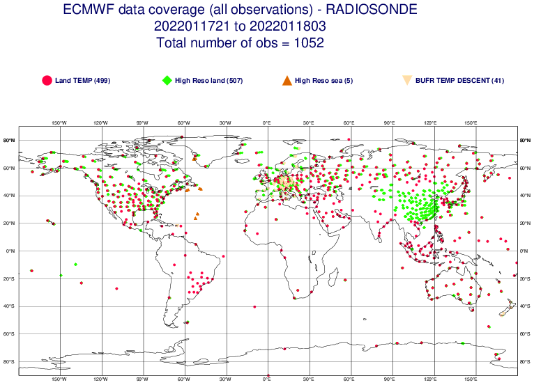
  7. No. [Edit to add] And if there is a sonde missing for ECMWF, there is a 99% chance it's missing for everyone.
  8. Yes, it's called GRAPES: https://public.wmo.int/en/media/news-from-members/cma-upgrades-global-numerical-weather-prediction-grapesgfs-model-china Every time someone mentions "sampling", I die a little inside. Almost all meteorological information is shared internationally....nearly all modeling centers start from the same base set of data from which to choose/utilize. There are two main exceptions: 1) some data is from the private sector and has limits as to how it can be shared, 2) some places aren't allowed to use certain data from some entities; e.g., here in the US we aren't allowed to us observations from Chinese satellites which isn't the case at ECMWF/UKMO, etc. There can be other differences that are a function of data provider, such as who produces retrievals of AMVs, GPS bending angle, etc. Generally speaking, differences is in how the observations are used...not in the observations themselves. No, see above regarding data. The signal that was in the "innovation" field, which is just the difference between a short term forecast and the observations. In this case, the signal is real as a result of the shockwave and showed up in certain observations that are used in NWP. I do not have it handy, but I bet we would see similar signals in other NWP systems for that same channel. Further, what was shown was just the information that went into that particular DA cycle and not the analysis itself. Even if that signal was put into the model, it would be very short lived....both in terms of that particular forecast but subsequent cycles. It has no bearing on the current set of forecasts.
  9. GEFS is initialized from the GFS analysis. The control for the GEFS is initialized directly from the analysis (interpolated to lower resolution). The members are then perturbed through combinations of perturbations derived from the previous GDAS cycle's short term forecast perturbations....all centered about the same control GFS analysis. So yes, recon data would impact GEFS through the GFS analysis.
  10. There is a plan for a "unified" gfsv17 and gefs13 upgrade. It is still a couple of years down the road but development is happening now. The ensemble upgrade is complicated by the reforecast requirement to provide calibration for subseasonal (and other) products.
  11. GEFS mean scores are statistically better than deterministic GFS for the medium range....but that has to come with all kinds of caveats (e.g. domain/temporally averaged, not necessarily applicable to individual events, etc.).
  12. what, why? models nail temperature forecasts to the degree, in complicated setups, at 6+ day lead times, all the time. oh wait....
×
×
  • Create New...